It looks like you're using an Ad Blocker.
Please white-list or disable AboveTopSecret.com in your ad-blocking tool.
Thank you.
Some features of ATS will be disabled while you continue to use an ad-blocker.

1959 crop-circles?
page: 14
share:
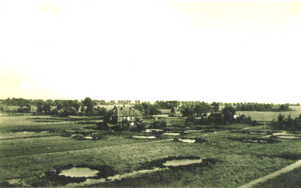
Here's a case I worked on two years ago and for which I haven't found any definite explanation.
Maybe some fellow members here on ATS could help me to solve it once and for all!
It's about an illustration that appears on a crop-circle related book, written by Andreas Müller, a Deutsch writer:
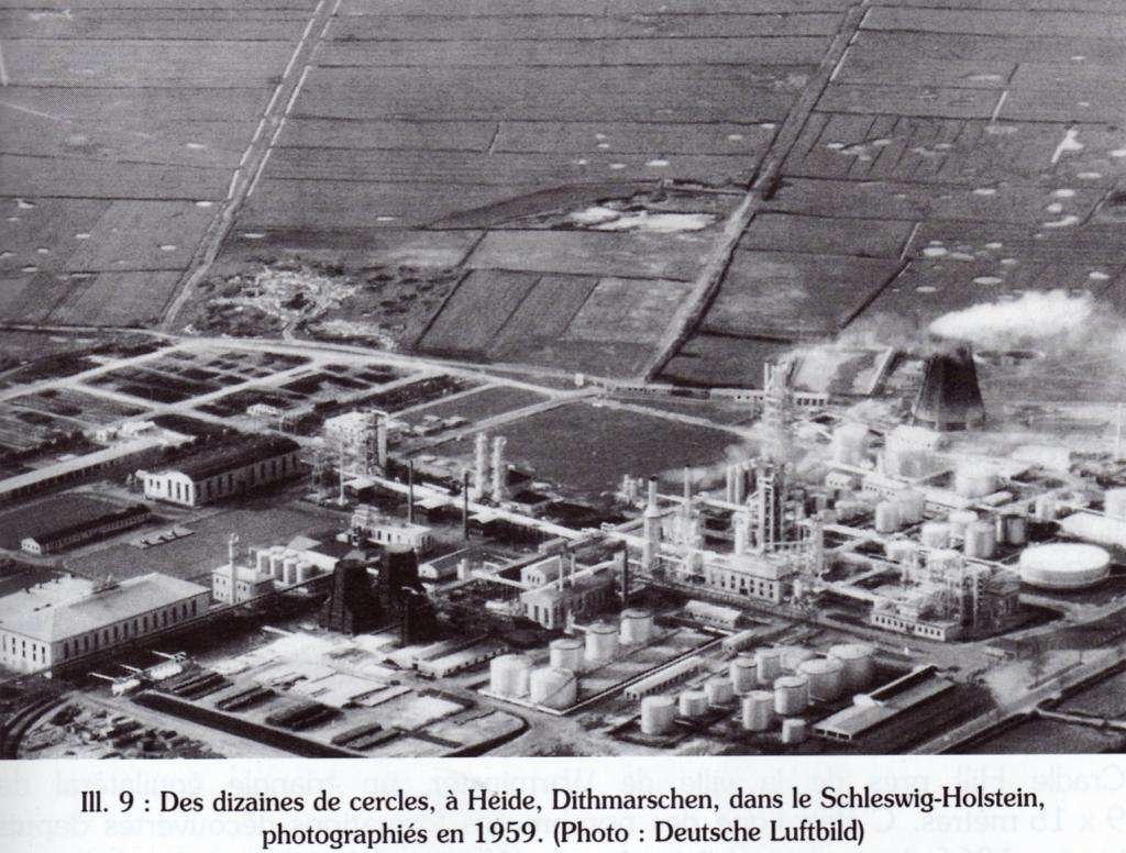
The book I worked on is written in French and the legend says: "Dozens of circles, at Heide, Dithmarschen, in the Schleswig-Holstein, photographed in 1959 (Photo: Deutsche Luftbild)
Then, I've done a search about "Andreas Müller" to see if I can contact him and get some more informations about this photo. I succeed and sent him an email on which he quickly replied:
"the image was published in a book titeled: "Deutschland im Luftbild - Süden, Westen, Norden", edited by Bernd Lohse (but he was seemingly not the photographer of the image itself). The book was printed in 1959 by the publisher "Umschau Verlag" in Frankfurt.
The photographer in person is not named as the image is copyrighted by the "Deutsche Luftbild". I guess it would be very hard to trace this very photographer down because the "Deutsche Luftbild" has many, many thousands of aerial photos in stock. Also one must keep in mind that this image must have been taken long ago, surly before 1959!
I personally also think that finding the photographer would not add much more information onto the possible "crop circles" seen in the background as they were not his interest while taking the image of the oil refinery. I doubt that he was even aware of them while taking the image.
So all we are left is the image itself with the features in the background, that - at least in my view - show a fascinating resemblance to modern day crop circles. Of course in face of the lack of close up one can not be completely sure, so the evidential quality of this image should be rated more as anecdotal than as a water roof evidence for such early crop circles in Schleswig-Holstein.
Some people already suggested the "circles" could be remains of bomb craters from World War II. However, while I now that such locations were targets for allied bomb attacks, I doubt that such craters would remain visible as "clear cut" as the circles appear in the image after nearly 15 years. One can clearly see at least a few of the features are very circular, get crossed by the tractor lines and where the standing crop causes a shadow onto the seemingly flattened. In my view unlikely to be the remains of a WW2-crater - especially because the field were worked on again soon after war. One would expect the farmer to fill such craters soon after the war to continue his farming, especially as food was very much needed at that time and each unused part of a field was a loss of food and income. But then again ...without a close-up we can never be sure.
I hope this information was helpful.
Best wishes
Andreas Müller
Next step for me was to find the related book and to buy it to check what Muller was saying and have a better look at the image itself.
After hours of research, I finally succeed in finding it and bought it.
Unfortunately, there was no more informations about this picture in it, except a short description that can be translated like this:
"At the heart of a fertile region located along the western coast of Holstein, a new industrial area has emerged. The fine mosaic designed by irrigation ditches crossing this stretch of polders, is interrupted near Heide, a imposing and glittering refinery. Its large oil reservoirs are dominated by the cracking tower, 83 meters high, which is the heart of the facility.
The refinery receives light oil extracted from 60 wells by drilling towers Heider. Oil tankers docking at Polder Brunsbüttel there unload heavy oil which is routed directly to the refinery by a pipeline of 31 km long. In 1856, farmers found Dithmarsch first deposits of chalk oleaginous oily. Now, the rigs have multiplied around Heide. "
So, what's left are some hypothesis that can be summarized as follow:
- WW2 craters traces
- Lodged wheat
- Geologic formation
- Other?
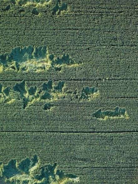
Lodged wheat don't appears to have circular patterns though:
source
I tend to believe that it could be some geological feature that have to do with the calcareous subsoil, but I wasn't able to find similar samples yet, especially with circular patterns.
For those who are interested, I can provide a full hi-res scan of the original photo.
Thanks!
Maybe some fellow members here on ATS could help me to solve it once and for all!
It's about an illustration that appears on a crop-circle related book, written by Andreas Müller, a Deutsch writer:
The book I worked on is written in French and the legend says: "Dozens of circles, at Heide, Dithmarschen, in the Schleswig-Holstein, photographed in 1959 (Photo: Deutsche Luftbild)
Then, I've done a search about "Andreas Müller" to see if I can contact him and get some more informations about this photo. I succeed and sent him an email on which he quickly replied:
"the image was published in a book titeled: "Deutschland im Luftbild - Süden, Westen, Norden", edited by Bernd Lohse (but he was seemingly not the photographer of the image itself). The book was printed in 1959 by the publisher "Umschau Verlag" in Frankfurt.
The photographer in person is not named as the image is copyrighted by the "Deutsche Luftbild". I guess it would be very hard to trace this very photographer down because the "Deutsche Luftbild" has many, many thousands of aerial photos in stock. Also one must keep in mind that this image must have been taken long ago, surly before 1959!
I personally also think that finding the photographer would not add much more information onto the possible "crop circles" seen in the background as they were not his interest while taking the image of the oil refinery. I doubt that he was even aware of them while taking the image.
So all we are left is the image itself with the features in the background, that - at least in my view - show a fascinating resemblance to modern day crop circles. Of course in face of the lack of close up one can not be completely sure, so the evidential quality of this image should be rated more as anecdotal than as a water roof evidence for such early crop circles in Schleswig-Holstein.
Some people already suggested the "circles" could be remains of bomb craters from World War II. However, while I now that such locations were targets for allied bomb attacks, I doubt that such craters would remain visible as "clear cut" as the circles appear in the image after nearly 15 years. One can clearly see at least a few of the features are very circular, get crossed by the tractor lines and where the standing crop causes a shadow onto the seemingly flattened. In my view unlikely to be the remains of a WW2-crater - especially because the field were worked on again soon after war. One would expect the farmer to fill such craters soon after the war to continue his farming, especially as food was very much needed at that time and each unused part of a field was a loss of food and income. But then again ...without a close-up we can never be sure.
I hope this information was helpful.
Best wishes
Andreas Müller
Next step for me was to find the related book and to buy it to check what Muller was saying and have a better look at the image itself.
After hours of research, I finally succeed in finding it and bought it.
Unfortunately, there was no more informations about this picture in it, except a short description that can be translated like this:
"At the heart of a fertile region located along the western coast of Holstein, a new industrial area has emerged. The fine mosaic designed by irrigation ditches crossing this stretch of polders, is interrupted near Heide, a imposing and glittering refinery. Its large oil reservoirs are dominated by the cracking tower, 83 meters high, which is the heart of the facility.
The refinery receives light oil extracted from 60 wells by drilling towers Heider. Oil tankers docking at Polder Brunsbüttel there unload heavy oil which is routed directly to the refinery by a pipeline of 31 km long. In 1856, farmers found Dithmarsch first deposits of chalk oleaginous oily. Now, the rigs have multiplied around Heide. "
So, what's left are some hypothesis that can be summarized as follow:
- WW2 craters traces
- Lodged wheat
- Geologic formation
- Other?
Lodged wheat don't appears to have circular patterns though:
source
I tend to believe that it could be some geological feature that have to do with the calcareous subsoil, but I wasn't able to find similar samples yet, especially with circular patterns.
For those who are interested, I can provide a full hi-res scan of the original photo.
Thanks!
edit on 17-5-2012 by elevenaugust because: (no reason given)
reply to post by elevenaugust
Hello elevenaugust,
I think craters from WW2 would be a reasonable explanation.
Even today you can see craters from that timeframe and the plant would sure be a strategic target.
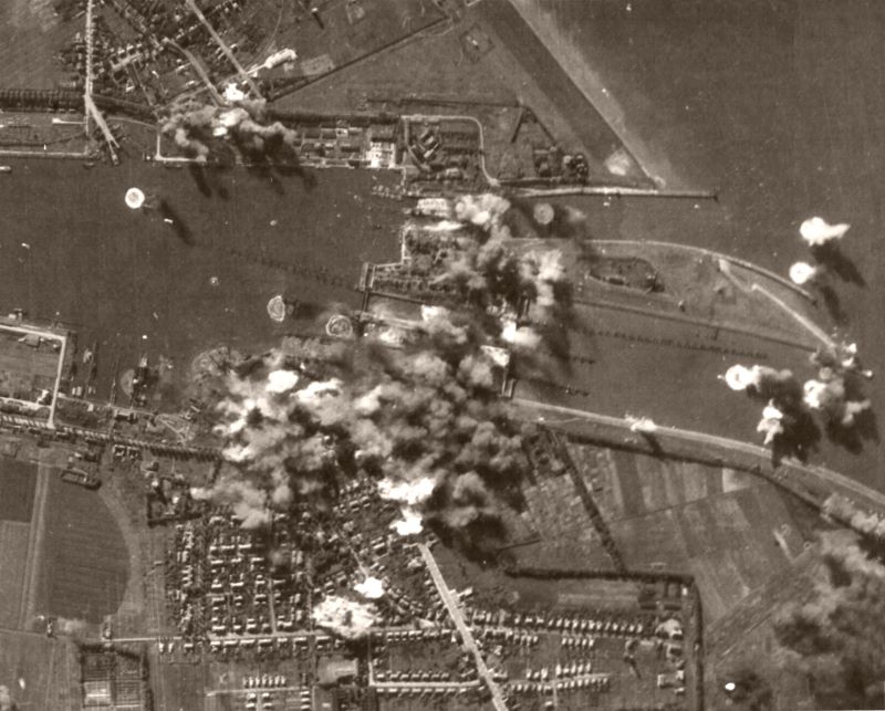
I include a picture of the bombing of Brunsbüttel which belongs to Dithmarschen, I think the similarities are highly visible.
Have a nice day,
derpif
Hello elevenaugust,
I think craters from WW2 would be a reasonable explanation.
Even today you can see craters from that timeframe and the plant would sure be a strategic target.
I include a picture of the bombing of Brunsbüttel which belongs to Dithmarschen, I think the similarities are highly visible.
Have a nice day,
derpif
edit on 17-5-2012 by derpif because: (no reason given)
Originally posted by derpif
reply to post by elevenaugust
Hello elevenaugust,
I think craters from WW2 would be a reasonable explanation.
Even today you can see craters from that timeframe and the plant would sure be a strategic target.
I include a picture of the bombing of Brunsbüttel which belongs to Dithmarschen, I think the similarities are highly visible.
Thank you for you reply!
Well, I also thought of this explanation, but shouldn't the crops since then (14 years later after the end of WW2) hide the craters?
Your photo is interesting, but do you have the same taken some years after the WW2?
reply to post by elevenaugust
No, unfortunately I'm not able to find aerial pictures from after WW2.
I think you probably wouldn't see the craters from ground level, but I'm sure you still would see them from above.
I'm by no means an expert on this though, and it's just my guess
No, unfortunately I'm not able to find aerial pictures from after WW2.
I think you probably wouldn't see the craters from ground level, but I'm sure you still would see them from above.
I'm by no means an expert on this though, and it's just my guess
reply to post by elevenaugust
I've had a look to see if I could find the area using Google Maps to see how it looks today... I think I may have found it here
Although not prominent, there does seem to be some small patchy circular areas still barely viewable.
I've had a look to see if I could find the area using Google Maps to see how it looks today... I think I may have found it here
Although not prominent, there does seem to be some small patchy circular areas still barely viewable.
edit on 17-5-2012 by dsm1664 because:
(no reason given)
reply to post by elevenaugust
Interesting photo.
Although I believe with the above poster, they could be craters from the war.
On a related topic, I always find that crop circles have become much more elaborate in the past few years as opposed to the ones found from decades past. Almost if the technology is advancing, from the same "beings" that create them to begin with. I can't see how this is possible, with any kind of "being" that would have the technology to travel to this planet, advancing their skills to make crop circles...but no communication.
Therefore, I remain skeptical about them and believe they are 100% man-made.
reply to post by elevenaugust
Yes! They look like crop circles. It is probably a message trying to draw attention to the nuclear power plant in front of the feild. Nuclear power is a dangerous and stupid way to get energy. I believe Hydrogen, wind, and solar are better ideas. It is a passive message which points out they are there watching us. The messages leaves the viewer room to make a free choice. I think these beings use math, geometry, and patterns as language. It could be the individuals are in a different dimension right here, or in the future. What amazes me is that no one communicates back to them in the fields. Remember we don't talk to the elephants, dolphins, dogs in their language either. Yet they have their complex thoughts and comunicate with language to each other.
Yes! They look like crop circles. It is probably a message trying to draw attention to the nuclear power plant in front of the feild. Nuclear power is a dangerous and stupid way to get energy. I believe Hydrogen, wind, and solar are better ideas. It is a passive message which points out they are there watching us. The messages leaves the viewer room to make a free choice. I think these beings use math, geometry, and patterns as language. It could be the individuals are in a different dimension right here, or in the future. What amazes me is that no one communicates back to them in the fields. Remember we don't talk to the elephants, dolphins, dogs in their language either. Yet they have their complex thoughts and comunicate with language to each other.
reply to post by havok
Yes, I fully agree with what you said.
About the crop-circles to be 100% man-made, what interests me is how they succeed in creating those that we can see in the rapeseed field. See my thread: Crop-circles: do you really understand what’s going on in the rape seed fields?
Yes, I fully agree with what you said.
About the crop-circles to be 100% man-made, what interests me is how they succeed in creating those that we can see in the rapeseed field. See my thread: Crop-circles: do you really understand what’s going on in the rape seed fields?
reply to post by elevenaugust
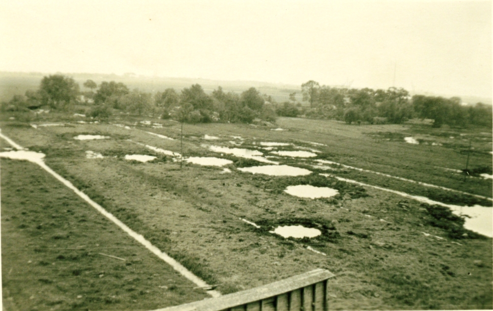
I have found two more pictures from that region that may be relevant.
That's how it looked after the attacks on the MAWAG oil refinery, which was located there.
I have found two more pictures from that region that may be relevant.
That's how it looked after the attacks on the MAWAG oil refinery, which was located there.
new topics
-
New House GOP Bill To Send Pro Hamas College Law Breakers to Gaza for 6 Months
Social Issues and Civil Unrest: 20 minutes ago -
Pentagon UFO Hunter Reveals What He Knows About Aliens: Nothing
Aliens and UFOs: 2 hours ago -
President Bidens Health is Declining Faster 5.8.2024 - He Should Stay Home.
2024 Elections: 3 hours ago -
Court of Appeals Agrees to Hear Trump Appeal to Flush Fani Willis
US Political Madness: 3 hours ago -
I "lost" a manuscript.
Rant: 6 hours ago -
Crocodile Reported in Water near a Buckinghamshire village in the UK
Pets: 6 hours ago -
Chris Cuomo, who pushed vaccine shots on CNN, admits Moderna vaccine destroyed his health
Mainstream News: 9 hours ago -
History Shows; Many Crisis Are Artificial I'm Order To Enslave People
Political Conspiracies: 9 hours ago
top topics
-
Chris Cuomo, who pushed vaccine shots on CNN, admits Moderna vaccine destroyed his health
Mainstream News: 9 hours ago, 20 flags -
Court of Appeals Agrees to Hear Trump Appeal to Flush Fani Willis
US Political Madness: 3 hours ago, 8 flags -
History Shows; Many Crisis Are Artificial I'm Order To Enslave People
Political Conspiracies: 9 hours ago, 6 flags -
Crocodile Reported in Water near a Buckinghamshire village in the UK
Pets: 6 hours ago, 6 flags -
President Bidens Health is Declining Faster 5.8.2024 - He Should Stay Home.
2024 Elections: 3 hours ago, 5 flags -
I "lost" a manuscript.
Rant: 6 hours ago, 3 flags -
Pentagon UFO Hunter Reveals What He Knows About Aliens: Nothing
Aliens and UFOs: 2 hours ago, 1 flags -
New House GOP Bill To Send Pro Hamas College Law Breakers to Gaza for 6 Months
Social Issues and Civil Unrest: 20 minutes ago, 0 flags
active topics
-
ATS HOF What Are Some of Your Favorite Threads
Members • 16 • : Coelacanth55 -
Judge Postpones Trump Classified Docs Trial INDEFINITELY
US Political Madness • 46 • : chr0naut -
New House GOP Bill To Send Pro Hamas College Law Breakers to Gaza for 6 Months
Social Issues and Civil Unrest • 2 • : WannabeeAuCourant -
Mood Music Part VI
Music • 3163 • : paviabari -
Breaking--Hamas Accepts New Cease Fire
Middle East Issues • 291 • : firerescue -
-@TH3WH17ERABB17- -Q- ---TIME TO SHOW THE WORLD--- -Part- --44--
Dissecting Disinformation • 879 • : daskakik -
To all ATS members of Faith - Prayer request
Religion, Faith, And Theology • 26 • : lilzazz -
Trump supporters training in the HILLS!!!!
US Political Madness • 79 • : rdambroso -
President Bidens Health is Declining Faster 5.8.2024 - He Should Stay Home.
2024 Elections • 2 • : StoutBroux -
New whistleblower Jason Sands speaks on Twitter Spaces last night.
Aliens and UFOs • 119 • : introufo2
4