It looks like you're using an Ad Blocker.
Please white-list or disable AboveTopSecret.com in your ad-blocking tool.
Thank you.
Some features of ATS will be disabled while you continue to use an ad-blocker.

Major UK Winter Storm 8th/9th December 2011 - NOW WITH FORECAST IMAGES
page: 3share:
Originally posted by DrHammondStoat
reply to post by jrmcleod
Well it look like you are right!
The met office have issued a take action warning (red on the maps). I have never seen this before
Hi .
Any chance you can post a link ?
Many thanks
www.metoffice.gov.uk...
I would keep checking, this has changed pretty quickly!
((Edit, I just got got a page not found thingy... if it doesn't work go to the main page at www.metoffice.gov.uk...
and then click on the UK forecast))
I would keep checking, this has changed pretty quickly!
((Edit, I just got got a page not found thingy... if it doesn't work go to the main page at www.metoffice.gov.uk...
and then click on the UK forecast))
edit on 7-12-2011 by DrHammondStoat because: (no reason given)
Just checked the BBC news website and they have new breaking news "Met office issues severe weather warning for the northern UK". Guess I should
get some supplies in or head south for the weekend.
Peace
Rock Ape
Peace
Rock Ape
Confusingly the BBC weather site doesn't appear to be making any fuss over it.
reply to post by tpg65
www.metoffice.gov.uk...
there you go bud. Click on Thursday - code red.
'take action'
www.metoffice.gov.uk...
there you go bud. Click on Thursday - code red.
'take action'
Would like to see some snow down in the South East, alas, it is not to be.....
And I bought a bloomin sledge this year boooooo !!!!!!
Oh, and no lie-in, because the kids will be going to school
And I bought a bloomin sledge this year boooooo !!!!!!
Oh, and no lie-in, because the kids will be going to school
Originally posted by DrHammondStoat
www.metoffice.gov.uk...
I would keep checking, this has changed pretty quickly!
Many thanks .
I will keep checking back and updating my facebook page .
Looks like Scotland will be hit hard.
Northern England seems to miss the worst.
Northern England seems to miss the worst.
This is the advice the met office are giving;
www.metoffice.gov.uk...
www.metoffice.gov.uk...
Current alert level: Level 2 - Alert and Readiness in one or more regions of England
Issued at: Wednesday 7 December 2011 at 09:57
There is a 60% probability of severe cold weather and icy conditions between 1800 on Thursday and 0000 on Saturday in parts of England. This weather could increase the health risks to vulnerable patients and disrupt the delivery of services. Please refer to the national Cold Weather Plan and your Trust's emergency plan for appropriate preventive action.
An unsettled regime will affect mainly western parts of England during Thursday evening and throughout Friday with snow showers potentially bringing significant accumulations to Northwest England and northern parts of West Midlands. Drifting snow is likely in these parts on higher ground. Please see the Met Office severe weather warning for more detailed information of areas affected (link below). www.metoffice.gov.uk... Further snow fall is possible on Saturday but is currently thought to be less than 60% risk. Further details will be issued on Thursday 8th Dec 2011.
Regional breakdown
Region Risk Comments
North East England 30% -
North West England 60% High risk of snow showers late Thursday and throughout Friday. These showers will be heavy at times bringing the risk of significant accumulations. This will be accompanied by strong winds bringing some drifting over higher ground. Icy conditions are expected in association with snowfall.
Yorkshire & the Humber 40% Low risk of snow showers affecting mainly western parts of the region during late Thursday and throughout Friday. Currently significant accumulations are not expected.
East Midlands 30% Low risk of snow showers affecting mainly western parts of the region during late Thursday and throughout Friday. Currently significant accumulations are not expected.
West Midlands 60% Snow showers affecting mainly northern parts of the region during late Thursday and throughout Friday. These showers are likely to be heavy at times in northern parts with this area most at risk of significant accumulations and icy conditions.
East of England 0% -
yep, even reported on the News web sites now.
It is not often that weather warnings and news reports are escalated this quick.
For people outside the UK, we do have weather warnings etc but not normally the 'take action' red warnings and weather forecasts changing / worsening very quickly.
I visit various weather forums where amateurs and professionals have been talking about tomorrows weather for the past few days.
It looks like the UK is in for a battering.
Valid from - 08 Dec 2011, 10:00
Valid to - 09 Dec 2011, 06:00
Winds will increase during Thursday morning with severe gales developing across many northern and central parts of the UK, and some particularly damaging storm force winds likely to affect parts of the north, including some major population centres in Scotland.
The risk of disruption is considered highest across central and southern Scotland where the police are advising that conditions for travel will be extremely poor and that travellers are likely to experience significant delays.
Winds should tend to ease from the west on Thursday night with the severe gales becoming confined to NE Scotland by the early hours of Friday.
Heavy rain and hill snow are additional hazards that will accompany the gales (see our snow warnings for details).
It's been building up for days, it's been shockingly cold here in the north west with literally dozens of hail showers - maybe one every hour or so.... This morning the wind was very harsh and the hail was painful. Now i'm snug at home with a mince pie, central heating and a cup of tea.
Originally posted by DrHammondStoat
reply to post by jrmcleod
Well it look like you are right!
The met office have issued a take action warning (red on the maps). I have never seen this before
Take action warnings are reserved only for the most severe weather warnings in the UK. This denotes a risk to life and property. You only really ever see these if there is possibility of serious danger to the public.
Some examples are extreme thunderstorms in summer but their publicity is rare in the UK
Just to reitterate to anyone joining this thread now. The weather forecast for Friday will be severe. This isn't just like any other winter storm,
this has a large potential to be dangerous to life and property.
The Met Office have issued a take action alert - 36 hours out, which is unusual in itself. The dangers posed are
1. Severe wind, in excess of 80mph with gusts possibly exceeding 100mph
2. Severe wind chill lower than -15oC
3. Storm surge along the entire North Sea
4. Blizzard conditions with drifting snow
This weather event is not to be shrugged off if you live in the Northern England, Scotland. Make sure you are ready for loss of power and very cold weather. Check on neighbors if you can and limit your travel if possible through Friday and Friday Night.
(I'm trying to find info on the Storm Surge so that i can post info on its projected severity). Please remember that this surge is potentially dangerous because it will coincide with a full moon and high tide. Sea levels along the East Coast could rise by a considerable amount. Will revert back when i find some info.

Originally posted by tpg65
You can can see hourly satellite updates here
www.metoffice.gov.uk...
A better website for the sat images is Sat24. It given you the opportunity to see Infrared as well.
Please bear in mind that this LP is very small at the moment and not very strong. It is the Jet Stream and Sheer that is going to fuel this and strengthen it. Watch it grow over the next 12 hours or so. You'll begin to see its movements and size increase over the next day.
For those looking for a decent precipitation and temperature radar. I suggest Precipitation and Temperature.
edit on 7/12/11 by jrmcleod because: (no reason given)
Originally posted by jrmcleod
Originally posted by tpg65
You can can see hourly satellite updates here
www.metoffice.gov.uk...
A better website for the sat images is Sat24. It given you the opportunity to see Infrared as well.
Please bear in mind that this LP is very small at the moment and not very strong. It is the Jet Stream and Sheer that is going to fuel this and strengthen it. Watch it grow over the next 12 hours or so. You'll begin to see its movements and size increase over the next day.
For those looking for a decent precipitation and temperature radar. I suggest Precipitation and Temperature.edit on 7/12/11 by jrmcleod because: (no reason given)
Many thanks for the link and the info .
I'm off to take a look .
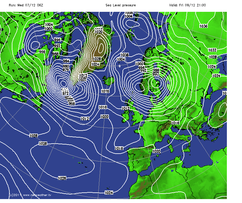
Edited the OP to show another image of a possible second, more sever storm brewing off of Greenland that could make this Fridays storm seem like its
little brother.
I will be keeping an eye and updating on this second storm.
Saturday may only be brief respite...
I will be keeping an eye and updating on this second storm.
Saturday may only be brief respite...
edit on 7/12/11 by jrmcleod because: (no reason given)
reply to post by mr-lizard
It's been very windy these past few nights up here, been raining on and off this morning, still high winds.
The mountains/fells are covered in snow, but not seen any snow here towards the coast.
Being pretty much on the Scottish border (can see Scotland over the Solway Firth), I'm expecting we will see some of the nastiness over the coming days.
new topics
-
I need help finding the ATS GOLD content contributor Image
General Chit Chat: 5 minutes ago -
Biden accepts Trumps debate challenge
2024 Elections: 55 minutes ago -
Canada wants to kill off the brown people
Mainstream News: 1 hours ago -
10 Year Old Indiana Boy Victim of Bullying Commits Suicide
Education and Media: 3 hours ago -
Want Some Secret Knowledge?
Paranormal Studies: 3 hours ago -
Slovakian prime minister shot in 'brutal' attack while meeting supporters
Mainstream News: 4 hours ago -
WATCH 1740 Russian Soldiers Destroyed By Ukrainian Forces While Advancing In Kharkiv
World War Three: 4 hours ago -
Ohio finds over 100 non-citizens on votrer roles
US Political Madness: 7 hours ago -
Interview with Vladimir Putin to the Chinese Xinhua Agency
Politicians & People: 7 hours ago -
Meeting of a Russian hunter with a bear
ATS Skunk Works: 8 hours ago
top topics
-
Ohio finds over 100 non-citizens on votrer roles
US Political Madness: 7 hours ago, 11 flags -
W.H.O when this is signed it is over.
US Political Madness: 14 hours ago, 9 flags -
Slovakian prime minister shot in 'brutal' attack while meeting supporters
Mainstream News: 4 hours ago, 7 flags -
Biden accepts Trumps debate challenge
2024 Elections: 55 minutes ago, 6 flags -
10 Year Old Indiana Boy Victim of Bullying Commits Suicide
Education and Media: 3 hours ago, 4 flags -
Interview with Vladimir Putin to the Chinese Xinhua Agency
Politicians & People: 7 hours ago, 2 flags -
Meeting of a Russian hunter with a bear
ATS Skunk Works: 8 hours ago, 2 flags -
Want Some Secret Knowledge?
Paranormal Studies: 3 hours ago, 2 flags -
Canada wants to kill off the brown people
Mainstream News: 1 hours ago, 2 flags -
WATCH 1740 Russian Soldiers Destroyed By Ukrainian Forces While Advancing In Kharkiv
World War Three: 4 hours ago, 1 flags
active topics
-
The biggest problem with the Hush money trial
US Political Madness • 240 • : CarlLaFong -
Biden accepts Trumps debate challenge
2024 Elections • 18 • : Annee -
WATCH 1740 Russian Soldiers Destroyed By Ukrainian Forces While Advancing In Kharkiv
World War Three • 68 • : Kurokage -
Candidate TRUMP Now Has Crazy Judge JUAN MERCHAN After Him - The Stormy Daniels Hush-Money Case.
Political Conspiracies • 1706 • : xuenchen -
I need help finding the ATS GOLD content contributor Image
General Chit Chat • 0 • : Encia22 -
-@TH3WH17ERABB17- -Q- ---TIME TO SHOW THE WORLD--- -Part- --44--
Dissecting Disinformation • 1020 • : Thoughtful3 -
Slovakian prime minister shot in 'brutal' attack while meeting supporters
Mainstream News • 13 • : angelchemuel -
Fake Aurora's produced by HAARP
Science & Technology • 112 • : Oldcarpy2 -
Don Trump-Quixote
Political Issues • 29 • : lilzazz -
15.6 Percent of US Population Now Foreign Born - 51.6 Million
Social Issues and Civil Unrest • 54 • : MrGashler