It looks like you're using an Ad Blocker.
Please white-list or disable AboveTopSecret.com in your ad-blocking tool.
Thank you.
Some features of ATS will be disabled while you continue to use an ad-blocker.

Major southern San Andreas earthquakes modulated by lake-filling events
page: 124
share:
** I meant to put this thread in Fragile Earth, sorry about that...
Major southern San Andreas earthquakes modulated by lake-filling events
The quotes used are from a new Phys.org article that won't link properly. The title and working link is the acedemic pay wall version.
**************
If you have ever flown into Southern California from the East, you've flown over The Salton Sea. It is an endorheic basin (like Lake Tulare) that periodically fills when the flow of the Colorado River diverts itself West in heavy runoff years.
Since the area was developed and we built canals to divert River water it no longer flows naturally. 1905 may have been one such year. Heavy runoff breached the canals and the river did what it periodically does and filled this basin.
People, not realizing this, fully stopped the flood. It filled only a fraction of its historical level. They believed crises mostly averted. But maybe it was supposed to do that.
It turns out if the San Andreas is a camel's back; the periodic lake is its necessary straw.
Everything learned about the eventual quake gets scarier and scarier. It's now looking like because man stopped a lake from filling, it delayed the obligatory earthquake and may have made it worse. What's the expected periodicity of a dry basin vs a filled basin? A lot of questions.
But if you assume it could have happened around 1905-1910 as well, that's about 115 years of extra stress buildup. Perhaps without human intervention it might be a non-issue. Had there never been humans to divert the flow 2023 might have been a fill year, it is up north.
This is pushing the expected event (when it does happen later than predicted) to the very upper limits of a strike-slip transform fault. Range of 7.9 to 8.4. A ground rupture that starts by Coachella and unzips the state past Palmdale. With every location along that path experiencing the maximum intensity. Not so much learning to swim as much as it is learning to drive on a collapsing interchange.
*** Phys.org article***
Major southern San Andreas earthquakes modulated by lake-filling events
The quotes used are from a new Phys.org article that won't link properly. The title and working link is the acedemic pay wall version.
**************
If you have ever flown into Southern California from the East, you've flown over The Salton Sea. It is an endorheic basin (like Lake Tulare) that periodically fills when the flow of the Colorado River diverts itself West in heavy runoff years.
The ancient predecessor to the Salton Sea is now referred to as Lake Cahuilla, which, when full, was 40 times larger in volume than its modern-day remnant. Lake Cahuilla was so vast that it stretched from the Coachella Valley south into Mexico and from as far west as Plaster City, California, to as far east as the Chocolate Mountains, according to study co-author Thomas Rockwell, a professor of geology at San Diego State.
A full Lake Cahuilla reached an elevation of about 40 feet above sea level, with a maximum depth of more than 300 feet before it started to spill again. By contrast, the Salton Sea currently reaches a height of about 240 feet below sea o with a maximum depth of about 50 feet.
Since the area was developed and we built canals to divert River water it no longer flows naturally. 1905 may have been one such year. Heavy runoff breached the canals and the river did what it periodically does and filled this basin.
People, not realizing this, fully stopped the flood. It filled only a fraction of its historical level. They believed crises mostly averted. But maybe it was supposed to do that.
It turns out if the San Andreas is a camel's back; the periodic lake is its necessary straw.
Researchers found a pattern of Colorado River waters pouring into Lake Cahuilla and accompanying large earthquakes before the lake periodically dried up. Lake Cahuilla is believed to have been full six times in the last millennium: roughly the periods of 930 to 966, 1007 to 1070, 1192 to 1241, 1486 to 1503, 1618 to 1636, and 1731 to 1733.
"By looking at the earthquake history, and its relationship to the lakes, we realize that most of the earthquakes have occurred when a lake was present," Rockwell said.
Of the seven major quakes researchers found, six occurred when Lake Cahuilla either was filling up or was at a peak level.
Everything learned about the eventual quake gets scarier and scarier. It's now looking like because man stopped a lake from filling, it delayed the obligatory earthquake and may have made it worse. What's the expected periodicity of a dry basin vs a filled basin? A lot of questions.
But if you assume it could have happened around 1905-1910 as well, that's about 115 years of extra stress buildup. Perhaps without human intervention it might be a non-issue. Had there never been humans to divert the flow 2023 might have been a fill year, it is up north.
This is pushing the expected event (when it does happen later than predicted) to the very upper limits of a strike-slip transform fault. Range of 7.9 to 8.4. A ground rupture that starts by Coachella and unzips the state past Palmdale. With every location along that path experiencing the maximum intensity. Not so much learning to swim as much as it is learning to drive on a collapsing interchange.
*** Phys.org article***
edit on 21-6-2023 by Degradation33 because: (no reason given)
edit on Wed Jun 21 2023 by DontTreadOnMe because: moved to
Fragile Earth
edit on 6/21/23 by Ksihkehe because: Added source for quotes.
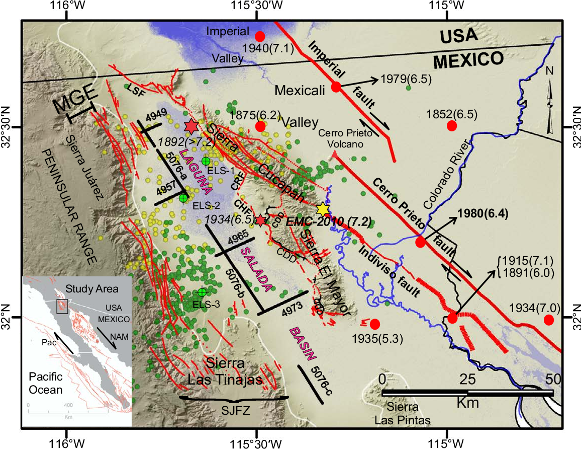
Here are some images to help wrap our minds around this, I love the topic, Im just a novice but the accompanying earthquake history map bares that out
somewhat, though the area is getting quakes it's just smaller ones more frequently than larger ones. These theoretically could place the stress at
different places and at different levels. Those mid-range blue quakes along the San Jacinto Fault could have relieved or redirected pressure
elsewhere perhaps down the Baha California peninsula
pubs.geoscienceworld.org...
www.nature.com...
pubs.geoscienceworld.org...
www.nature.com...
Hydrologic loads can stimulate seismicity in the Earth’s crust1. However, evidence for the triggering of large earthquakes remains elusive. The southern San Andreas Fault (SSAF) in Southern California lies next to the Salton Sea2, a remnant of ancient Lake Cahuilla that periodically filled and desiccated over the past millennium3,4,5. Here we use new geologic and palaeoseismic data to demonstrate that the past six major earthquakes on the SSAF probably occurred during highstands of Lake Cahuilla5,6. To investigate possible causal relationships, we computed time-dependent Coulomb stress changes7,8 due to variations in the lake level. Using a fully coupled model of a poroelastic crust9,10,11 overlying a viscoelastic mantle12,13, we find that hydrologic loads increased Coulomb stress on the SSAF by several hundred kilopascals and fault-stressing rates by more than a factor of 2, which is probably sufficient for earthquake triggering7,8. The destabilizing effects of lake inundation are enhanced by a nonvertical fault dip14,15,16,17, the presence of a fault damage zone18,19 and lateral pore-pressure diffusion20,21. Our model may be applicable to other regions in which hydrologic loading, either natural8,22 or anthropogenic1,23, was associated with substantial seismicity.
edit on 21-6-2023 by putnam6 because: (no reason given)
a reply to: putnam6
I am a total nerd for this.
2010 was the most interesting recent year.
When the 7.2 hit in Mexico on Easter, stress transfered North. Then it jumped up to the San Jacinto fault from Laguna Salada, completely bypassing the Brawley Seismic Zone (the gateway to the Southern San Andreas known for earthquake swarms).
All the major aftershocks were in California as opposed to Mexico and mostly on the San Jacinto.
Everyone expected it to trigger the San Andreas and it seemingly transferred stress all around it.
South of where the San Jacinto meets the San Andreas (Cajon Pass) the San Jacinto is WAY more active than the final stretch of The San Andreas. To the Northeast of that location, the shear zone is way more active. It's weird. The San Andreas is allegedly the transform fault, but the San Jacinto (among others) have the activity you'd expect from a plate boundary. All around it is active, but it's fairly locked up in one spot.
There's some speculation (post Ridgecrest) the plate boundary itself is shifting onto adjacent faults, mostly to the north via the Garlock Fault, but this could be the case with the San Jacinto too. That's wild speculation though and a separate topic on its own. At very least it's a default transform fault by function of moving in place of the locked up parallel San Andreas.
This new idea (in the article) is great because it answers why the terminus of the Southern San Andreas isnt as active as it should be.
edit
on 21-6-2023 by Degradation33 because: (no reason given)
originally posted by: Degradation33
a reply to: putnam6
I am a total nerd for this.
2010 was the most interesting recent year.
When the 7.2 hit in Mexico on Easter, stress transfered North. Then it jumped up to the San Jacinto fault from Laguna Salada, completely bypassing the Brawley Seismic Zone (the gateway to the Southern San Andreas known for earthquake swarms).
All the major aftershocks were in California as opposed to Mexico and mostly on the San Jacinto.
Everyone expected it to trigger the San Andreas and it seemingly transferred stress all around it.
South of where the San Jacinto meets the San Andreas (Cajon Pass) the San Jacinto is WAY more active than the final stretch of The San Andreas. To the Northeast of that location, the shear zone is way more active. It's weird. The San Andreas is allegedly the transform fault, but the San Jacinto (among others) have the activity you'd expect from a plate boundary. All around it is active, but it's fairly locked up in one spot.
There's some speculation (post Ridgecrest) the plate boundary itself is shifting onto adjacent faults, mostly to the north via the Garlock Fault, but this could be the case with the San Jacinto too. That's wild speculation though and a separate topic on its own. At very least it's a default transform fault by function of moving in place of the locked up parallel San Andreas.
This new idea (in the article) is great because it answers why the terminus of the Southern San Andreas isnt as active as it should be.
Any time a region is that geologically active you want to watch it and figure out its dynamics. It could be releasing strain among the more recognizable fault lines or it could be cycling them around to another big slip.
So much different than New Madrid and the east coast fault lines.
Here is some light reading...
pubs.geoscienceworld.org...
Salton Trough Tectonic Overview
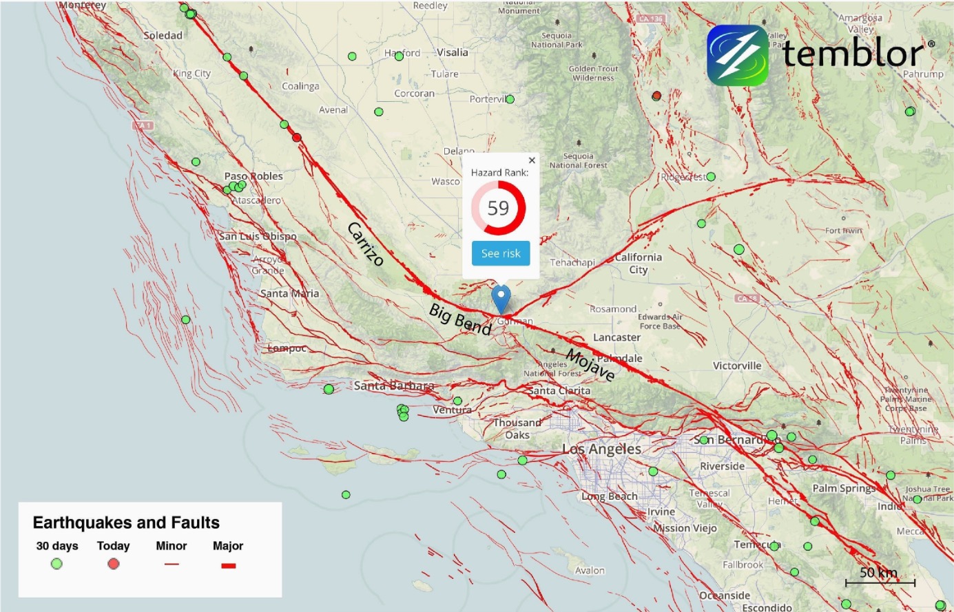
The San Andreas (SAF), San Jacinto (SJF), and Imperial (IF) faults are the major, throughgoing, northwest-striking dextral strike-slip faults that accommodate at least 80% of the total relative Pacific–North America plate motion. Estimated slip rates for all three faults vary depending on the type of study (geologic versus geodetic) and the time scale of measurement. Geodetic studies place the combined rate of the SAF and SJF between 35 and 40 mm/yr (Fay and Humphreys, 2005; Fialko, 2006; Lindsey and Fialko, 2013; Meade and Hager, 2005), but rates based on geologic data are generally lower than geodetically derived rates and are more variable between studies (Behr et al., 2010; Brothers et al., 2009; Fletcher et al., 2007; Kendrick et al., 2002; Rockwell et al., 1990). Regardless, both faults appear to transfer their entire slip budgets southward onto the IF, which carries 35 ± 2 mm/yr of the plate motion southward across the United States–Mexico border (Fig. 1; Bennett et al., 1996). The IF has ruptured twice during the past 82 yr (Mw 6.9 in 1940 and Mw 6.4 in 1979), whereas the SAF and SJF are both considered late in the interseismic phase of their earthquake cycles (e.g., Field et al., 2015). The southernmost 200 km of the SAF has not produced a major rupture in 300+ yr despite evidence that its average recurrence interval is between ~150 and 220 yr and it continues to accumulate significant strain (Behr et al., 2010; Blanton et al., 2020; Dingler et al., 2016; Fumal et al., 2002; Lindsey and Fialko, 2013; Philibosian et al., 2011; Seitz and Williams, 2007; Spinler et al., 2010). The potential for a Mw ≥7.0 rupture along the SAF to nucleate at the Salton Sea and propagate northward is a major concern for the Los Angeles metropolitan region (Brothers et al., 2011; Dingler et al., 2016; Olsen et al., 2006).
a reply to: putnam6
Anecdote:
When I was a kid we used to drive back and forth from Tucson to Phoenix for soccer and softball tournaments, and every time we'd pass Picacho Peak my Dad would point out the ancient volcano and I would learn all about igneous rock. He would blow my mind telling my sister and I how everything was created over millions of years.
* As it turns out, it's not actually a neck but an eroded formation overlayed by ancient lava flows. But for years people assumed it was.
I've been addicted to that boring crap ever since.
I was lucky enough to experience an Earthquake swarm at the Brawley Seismic Zone. They last a few days to a week, and once they get going, you just have to get there in time. I was less than 2 hours away. Experienced a bunch of 3 pointers, strongest was 4.0, which is nothing to scoff at when you purposely park at the center of the occurring swarm.
It is ominous to think half the state is sliding south and half the state is sliding north. At one point Palm Springs will pass San Fransisco within a few miles. Millions of years from now, but it will.
On the faults of Southern California, they're all related.
And it starts here:
The three Transform faults continue each other.
Cerro Prieto, Imperial, and San Andreas. The Cerro Prieto is like the bridge between the East Pacific Rise and The San Andreas along the plate boundary. That leads into the Imperial Fault which ends at the Brawley Seismic Zone (where I went), which then carries on as the San Andreas all the way to The Mendoncino Triple Junction off the far northern coast.
The Laguna Salada Fault (where the 7.2 happened) essentially transfers stress into The San Jacinto and Lake Elsinore Fault. The latter of the those becomes The Whittier Fault in The LA area. All 3 run parallel up the coast.
The San Andreas line of transform faults slip the most.
The San Jacinto slips next most
The Lake Elsinore - Whittier slip slightly slower.
Visually and conceptually I think the San Andreas is getting snagged at the "big bend" where it turns from NNW to WNW. And other accommodating faults are attempting to release as much as it can. It transfers onto the parallel running San Jacinto Fault on the Pacific Plate and into the East California Shear Zone (California/Nevada) on The North American Plate.
Without the surface loading of that lake it can't move. This seems by design. The Salton Sink was created in relation to the uplift of the mountains running to the East of the Coachella Valley and Salton Sea. They rose, the Salton Sink sank well below sea level.
San Diego has a natural sink in the middle of it. It's been artfully expanded, but Mission Bay is a sink that is associated with Mt. Soledad (near La Jolla). The motion of the Rose Canyon Fault (Underneath Interstate 5) uplifted Mt. Soledad at the same time it depressed Mission Bay. This is happening to a larger extent at The Salton Sea.
And I'm just saying it might be a timely freak of nature that a sink basin, 200 year flood zones, and the average periodicity of the fault is all connected, but probably not. A process seemingly intended to periodically fill and get the plate to slide past that one tricky point, despite it being just land deformation.
Earth says, "Hey, I need this lake to fill now and again to keep this plate moving."
edit on 22-6-2023 by Degradation33 because: (no reason
given)
a reply to: Degradation33
I messed up, or didn't clarify.
I should check this more. The Salton Sink (Trough) is a pull-apart basin, caused by the motions of overlapping faults. Transtension.
In this case it's two overlaping right lateral strike-slip faults. The Faults at Northern end of the East Pacific Rise (spreading ridge all the way to Mexicali near Cerro Prieto Volcano) and The San Andreas Fault.
Visually, it's like the earth is trying to continue the Gulf of California up through the Coachella Valley as relative motions cause stretching, compression, sinking and uplift simultaneously.
Also, the "Big Bend" is further north closer to Pakfield. Which Is also an area where the San Andreas locks up. I feel the same can be said for the area around Palm Springs. Not as pronounced of a bend, but enough lock up and slow the pull-apart motions.
edit on 23-6-2023 by Degradation33
because: (no reason given)
a reply to: Degradation33
Oh, Im completely following you here, you mapped it out perfectly, and you make a compelling argument counselor.
You aren't a professor or author perchance...
But if the SAF snags and it doesn't get released elsewhere does that mean that area is dead and what are the chances of it unzipping a new faultline? Aren't there some geologists that theorize SoCal has become so fractured with faultlines it decreases the magnitude, duration, and shake map area of EQs? Hopefully making them less destructive and costly.
I remember being mesmerized watching San Francisco and Oakland during the 89 quake and Northridge in 94, think Cali is infinitely more prepared than those areas around New Madrid.
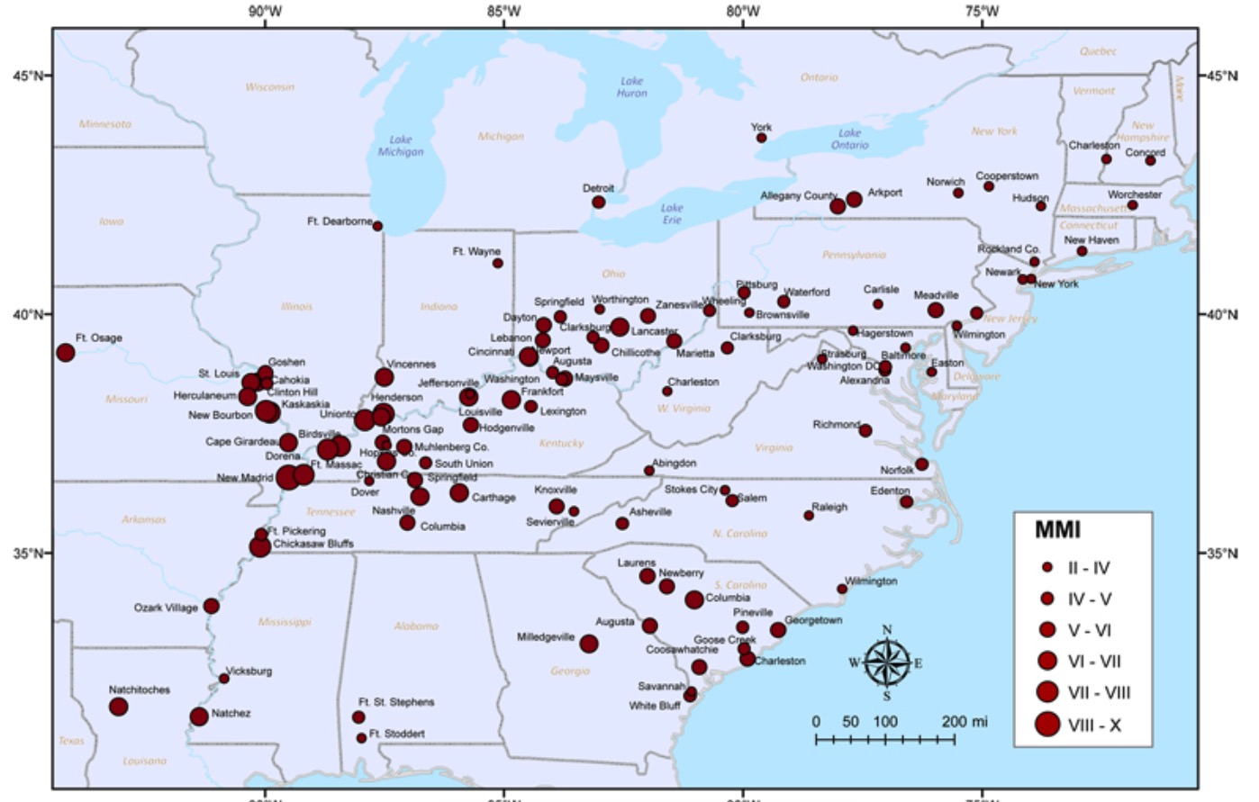
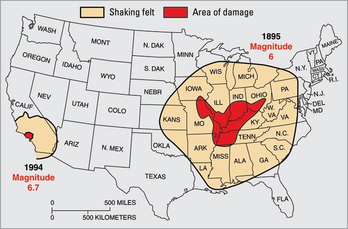
It's funny how life experiences will stick with you sometimes, for me, it was driving in Tennessee and coming across Reelfoot Lake. I'd always heard of New Madrid and the formation of Reelfoot, but once you see it and understand the enormity of it all, it's 12 miles from the New Madrid fault zone. Those 4 days the winter of 1811-12 the New Madrid Earthquakes were felt all over eastern North America. Supposedly based on past NM earthquakes there's a 30% chance of that size occurring in the next 50 years.
Oh, Im completely following you here, you mapped it out perfectly, and you make a compelling argument counselor.
You aren't a professor or author perchance...
But if the SAF snags and it doesn't get released elsewhere does that mean that area is dead and what are the chances of it unzipping a new faultline? Aren't there some geologists that theorize SoCal has become so fractured with faultlines it decreases the magnitude, duration, and shake map area of EQs? Hopefully making them less destructive and costly.
I remember being mesmerized watching San Francisco and Oakland during the 89 quake and Northridge in 94, think Cali is infinitely more prepared than those areas around New Madrid.
It's funny how life experiences will stick with you sometimes, for me, it was driving in Tennessee and coming across Reelfoot Lake. I'd always heard of New Madrid and the formation of Reelfoot, but once you see it and understand the enormity of it all, it's 12 miles from the New Madrid fault zone. Those 4 days the winter of 1811-12 the New Madrid Earthquakes were felt all over eastern North America. Supposedly based on past NM earthquakes there's a 30% chance of that size occurring in the next 50 years.
a reply to: putnam6
New Madrid is even more mysterious. Similar to The Gulf of California Rift Zone in that its a rift, but way different because California is along an existing continental boundary, and The Reel Foot Rift was a boundary trying to form, that failed.
At that point, about 500 MYA the Continent was underwater, of had just emerged, and Strattled the equator turned 90% clockwise. The plate failed to break apart, but it left the scar responsible for the earthquakes from Missouri to South Carolina.
There's another failed rift in Oklahoma/Texas. That one formed before the Reel Foot Rift, at around 550 MYA.
The continental margin at that point roughly follow today's gulf coast but a few hundred miles inland. Both rifts end at the Cambrian Era margin.
Basically North America tried to break apart twice and failed both times.
The Oklahoma Aulocogen is the one reactivated by fracking. I wouldn't really call it reactivated though. It's pretty much dead to anything above 6.0.
Most say New Madrid is shutting down, and Oklahoma was already mostly shut down. The reelfoot rift reactivated 150 MYA and may have significantly longer to go to shutdown completely. Still considered active. A 7.0-8.0 (or series) once every 500 years or thereabouts.
And the reason why California quakes don't travel is the way Califonia was built up from a nascent continental slab. The oldest rocks in California are the limestone deposited on this early self.
It started out as a shelf/slab and pretty much was sequentially stacked by compression from subduction or from accretion from the movement of the subducting plate, like a conveyer belt. This was caused by the oceanic Farralon Plate slipping under the North American. Like island arcs travelling across the ocean and piling up on California over time, fitting for this state, actually.
Then after* the Farralon Plate subducted for millions of years, the primary movers of transformation became the now converged Pacific/North American plates, and the San Andreas formed about 30 MYA. That then filled out California into what it is today.
* Part of Farralon Plate has yet to subduct (Cascadia). Its called the Juan De Fuca Plate, but its really the last part of a really large ancient plate.
The Transverse Ranges are my favorites of the SoCal mountains and worth letting Wikipedia explain:
California is a baby by comparison to the rest of North America, Southern California especially. San Bernardino Mountains have only been in that position, rotated 90 degrees, and uplifted a 4 million years at most.
New Madrid is even more mysterious. Similar to The Gulf of California Rift Zone in that its a rift, but way different because California is along an existing continental boundary, and The Reel Foot Rift was a boundary trying to form, that failed.
At that point, about 500 MYA the Continent was underwater, of had just emerged, and Strattled the equator turned 90% clockwise. The plate failed to break apart, but it left the scar responsible for the earthquakes from Missouri to South Carolina.
There's another failed rift in Oklahoma/Texas. That one formed before the Reel Foot Rift, at around 550 MYA.
The continental margin at that point roughly follow today's gulf coast but a few hundred miles inland. Both rifts end at the Cambrian Era margin.
Basically North America tried to break apart twice and failed both times.
The Oklahoma Aulocogen is the one reactivated by fracking. I wouldn't really call it reactivated though. It's pretty much dead to anything above 6.0.
Most say New Madrid is shutting down, and Oklahoma was already mostly shut down. The reelfoot rift reactivated 150 MYA and may have significantly longer to go to shutdown completely. Still considered active. A 7.0-8.0 (or series) once every 500 years or thereabouts.
And the reason why California quakes don't travel is the way Califonia was built up from a nascent continental slab. The oldest rocks in California are the limestone deposited on this early self.
It started out as a shelf/slab and pretty much was sequentially stacked by compression from subduction or from accretion from the movement of the subducting plate, like a conveyer belt. This was caused by the oceanic Farralon Plate slipping under the North American. Like island arcs travelling across the ocean and piling up on California over time, fitting for this state, actually.
Then after* the Farralon Plate subducted for millions of years, the primary movers of transformation became the now converged Pacific/North American plates, and the San Andreas formed about 30 MYA. That then filled out California into what it is today.
* Part of Farralon Plate has yet to subduct (Cascadia). Its called the Juan De Fuca Plate, but its really the last part of a really large ancient plate.
The Transverse Ranges are my favorites of the SoCal mountains and worth letting Wikipedia explain:
The Transverse Ranges result from a complex of tectonic forces and faulting stemming from the interaction of the Pacific Plate and the North American Plate along the dextral (right slip) San Andreas Fault system. Their orientation along an east–west axis as opposed to the general northwest–southeast trend of most California ranges results from a pronounced left step in the San Andreas Fault that occurred in the Pliocene (c. 4 million years ago) when southern reaches of the fault moved east to open the Gulf of California.[9] The crust within the Pacific Plate south of the ranges can not easily make the left turn westward as the entire plate moves northwestward, forcing pieces of the crust to compress and lift.
Prior to this shift of the fault to create the left bend, northwest–southeast trending rock belts in all of the Transverse Ranges began to rotate clockwise in the right shear of Pacific Plate – North American Plate motion.[10][11][12] This tectonic rotation began in Early Miocene Time and continues today.[13] The total rotation is about 90° in the Western Transverse Ranges and less (about 40°) in the eastern ranges.[14] Catalina Island shows the most rotation: almost 120°.[11]
California is a baby by comparison to the rest of North America, Southern California especially. San Bernardino Mountains have only been in that position, rotated 90 degrees, and uplifted a 4 million years at most.
edit on 23-6-2023 by Degradation33 because: (no reason given)
a reply to: Degradation33
I can fully believe that SAF EQ's are modulated by lake-filling events. There's plenty of evidence of hydrologic loads causing EQ's under reservoirs. However, sooner or later, even without the Salton Sea filling back up, there is going to be a large EQ along the southern segment of the SAF, as well as along the segments to the north of it. The two plates are moving past each other and sooner or later something has to give.
I can fully believe that SAF EQ's are modulated by lake-filling events. There's plenty of evidence of hydrologic loads causing EQ's under reservoirs. However, sooner or later, even without the Salton Sea filling back up, there is going to be a large EQ along the southern segment of the SAF, as well as along the segments to the north of it. The two plates are moving past each other and sooner or later something has to give.
new topics
-
Boy Scouts to be renamed next year
Other Current Events: 23 seconds ago -
Pfizer agrees to settle over 10,000 Zantac lawsuits after cancer causing substance found in drug
Medical Issues & Conspiracies: 26 minutes ago -
Judas Iscariot Slips The Hangman's Noose
Political Issues: 3 hours ago -
Murder Suicide Investigation Still Active 4 months later?
Other Current Events: 4 hours ago -
A Shout-out To truthseeker45 Hoot Hoot
General Chit Chat: 5 hours ago -
Ooooh...it worked!!
Members: 8 hours ago -
New House GOP Bill To Send Pro Hamas College Law Breakers to Gaza for 6 Months
Social Issues and Civil Unrest: 10 hours ago
top topics
-
Court of Appeals Agrees to Hear Trump Appeal to Flush Fani Willis
US Political Madness: 14 hours ago, 15 flags -
Ooooh...it worked!!
Members: 8 hours ago, 14 flags -
President Bidens Health is Declining Faster 5.8.2024 - He Should Stay Home.
2024 Elections: 13 hours ago, 9 flags -
New House GOP Bill To Send Pro Hamas College Law Breakers to Gaza for 6 Months
Social Issues and Civil Unrest: 10 hours ago, 9 flags -
Judas Iscariot Slips The Hangman's Noose
Political Issues: 3 hours ago, 8 flags -
Crocodile Reported in Water near a Buckinghamshire village in the UK
Pets: 17 hours ago, 6 flags -
A Shout-out To truthseeker45 Hoot Hoot
General Chit Chat: 5 hours ago, 4 flags -
I "lost" a manuscript.
Rant: 16 hours ago, 3 flags -
Pentagon UFO Hunter Reveals What He Knows About Aliens: Nothing
Aliens and UFOs: 12 hours ago, 2 flags -
Murder Suicide Investigation Still Active 4 months later?
Other Current Events: 4 hours ago, 2 flags
active topics
-
Boy Scouts to be renamed next year
Other Current Events • 0 • : 727Sky -
Black kids in the Bronx don't know what the word 'computer' is
People • 16 • : GotterDameron23 -
-@TH3WH17ERABB17- -Q- ---TIME TO SHOW THE WORLD--- -Part- --44--
Dissecting Disinformation • 884 • : daskakik -
New House GOP Bill To Send Pro Hamas College Law Breakers to Gaza for 6 Months
Social Issues and Civil Unrest • 81 • : Asher47 -
Pfizer agrees to settle over 10,000 Zantac lawsuits after cancer causing substance found in drug
Medical Issues & Conspiracies • 1 • : Kekrops -
I "lost" a manuscript.
Rant • 16 • : Raj54 -
Judas Iscariot Slips The Hangman's Noose
Political Issues • 18 • : Asher47 -
A Note Found On A Windshield in Italy.
General Conspiracies • 82 • : UpIsNowDown2 -
Pfizer is 'deeply sorry'
Diseases and Pandemics • 24 • : Kekrops -
Study Finds The More Covid Vaccine Doses You Have, the More Likely You Are to Get Covid
Medical Issues & Conspiracies • 42 • : Kekrops
24