It looks like you're using an Ad Blocker.
Please white-list or disable AboveTopSecret.com in your ad-blocking tool.
Thank you.
Some features of ATS will be disabled while you continue to use an ad-blocker.

Antarctic anomoly - Base? Aliens?
page: 2share:
originally posted by: Macenroe82
a reply to: Xcathdra
I have access to satellite data that is updated 3 times a day.
When I get in the office in the morning I’ll check those coordinates and send you some screen shots from what it looked like today
Awesome.. Thanks
a reply to: annoyedpharmacist
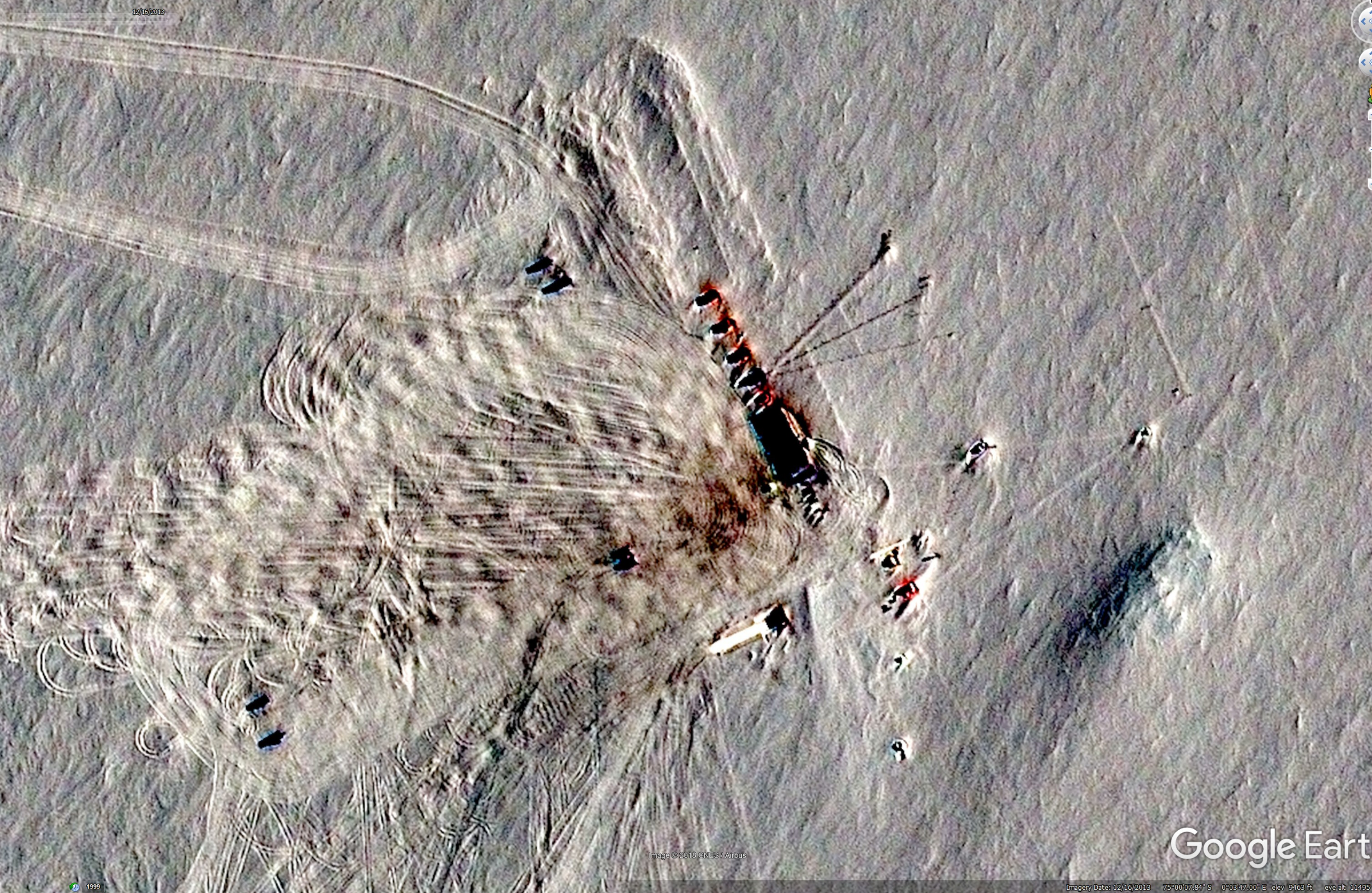
Rotating the direction in google earth while zoomed in on the 22 items that look like they are sticking out of the ice is weird. They almost look like communication towers and given the way the shadows look and the way the snow/ice disturbance is the same there is something definitely sticking up out of the ground.
Rotating the direction in google earth while zoomed in on the 22 items that look like they are sticking out of the ice is weird. They almost look like communication towers and given the way the shadows look and the way the snow/ice disturbance is the same there is something definitely sticking up out of the ground.
originally posted by: ausername
originally posted by: annoyedpharmacist
a reply to: ausername
heh. you read my mind with that one. when watching the video, this popped into my head immediately
Especially this image which has what looks like blood everywhere...
wtf?
I have to type an LOL here. Hate it but here it's appropriate. The guy in the video zooms in on the red areas and says:
"I know my shades of red, and this is about as disturbing shade of red I've seen."
LOL! Right? There are a thousand explanations on what that red color could be, before we go suggesting mass blood spillage.
And anyway, aren't these far-off satellite pictures notorious for being pixelated and looking pretty much nothing like whatever it is on the ground? Can we even trust the colors we're getting on GOOGLE EARTH?
I just have a feeling that some mass bloody runway somewhere, even in Antarctica, isn't going to be left for the rubes to view at their leisure on Google Earth.
But, XCATH! I'm impressed! XCATH with a little weirdness thread- nice! I see you in a whole new light now.
originally posted by: theantediluvian
a reply to: Xcathdra
No idea and so far no one else has come up with an answer either. For some reason there are 4 images (closeups) I took that are not uploading properly.
Too large? There's a max file size.
No it was smaller than the other pics I uploaded. I even changed the file type from jpg to png and it wouldnt take. I have had this issue before so not sure whats up.
The images in question from the 2013 image just close ups of the landing strip area and the anomaly area.
originally posted by: ausername
originally posted by: annoyedpharmacist
a reply to: ausername
heh. you read my mind with that one. when watching the video, this popped into my head immediately
I know right?
Especially this image which has what looks like blood everywhere...
wtf?
Pretty sure that looks exactly like an aerial shot of the final scene from The Thing (1982).
DONT LET IT ESCAPE!!!!
edit on 5837x6758America/ChicagovAmerica/Chicago9 by six67seven because: (no reason given)
a reply to: KansasGirl
lol thanks..
The red comment was goofy. I just looked beyond it. I am curious as to what it is though. Dye to mark the area, dye for the fuel (here in the states we use dye to denote between fuel for agriculture use only and normal use).
I found it weird and since it had enough info to find it on google earth and confirm what the guy was seeing I opted to branch out a bit lol.
a reply to: six67seven
lol!
I was thinking maybe some kind of arctic fuel additive, or some kind of deicing chemicals.
Looks like a mess, whatever it is.
Blood hasn't been ruled out yet....
lol!
I was thinking maybe some kind of arctic fuel additive, or some kind of deicing chemicals.
Looks like a mess, whatever it is.
Blood hasn't been ruled out yet....
Most dyed diesel, sold in the U.S., comes with a red coloring and is not usually available for purchase by the public. However, you may occasionally
see this dyed gasoline at a fuel station. By law, this dyed gas is only for use in off-road vehicles, such as farm tractors, heavy construction
equipment, and generators. Because it is not supposed to be used for on-road vehicles, this fuel is not taxed within the United States.
Diesel that is designated for use by U.S. government vehicles is dyed blue instead of red. This color variation helps to keep clear fuel used by the general public separate from the gas used by government on-road vehicles.
So yes the red may be most likely a dyed diesel spill.
Diesel that is designated for use by U.S. government vehicles is dyed blue instead of red. This color variation helps to keep clear fuel used by the general public separate from the gas used by government on-road vehicles.
So yes the red may be most likely a dyed diesel spill.
originally posted by: KansasGirl
a reply to: Xcathdra
What about in 2018? Has anyone looked today? Surely some peeps on this site have Google Earth.....
I have google earth pro.. The latest image is from 2016.
originally posted by: Xcathdra
originally posted by: KansasGirl
a reply to: Xcathdra
What about in 2018? Has anyone looked today? Surely some peeps on this site have Google Earth.....
I have google earth pro.. The latest image is from 2016.
I don't understand.
a reply to: Xcathdra
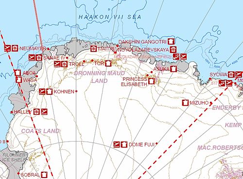
This appears to be Kohnen Station.
ETA:
Kohnen Station
This appears to be Kohnen Station.
ETA:
Kohnen Station
Kohnen-Station is a German summer-only polar research station in the Antarctic, able to accommodate up to 20 people. It is named after the geophysicist Heinz Kohnen (1938–1997), who was for a long time the head of logistics at the Alfred Wegener Institute.
The station opened on January 11, 2001, in Dronning Maud Land. The station is located at 75°00'S, 00°04'E, and 2892 m above sea level. It is located 757 km southeast of Neumayer-Station III, which lies on the Ekstrom Ice Shelf and provides logistics and administration for Kohnen-Station. Like the United Kingdom's Halley V station, the base is built on steel legs allowing the station to be jacked up as the height of the snow surface increases.
The station contains a radio room, a mess room, a kitchen, bathrooms, two bedrooms, a snow melter, a store, a workshop, and a power plant (100 kW). It is supplied by a convoy of 6 towing vehicles, which carry up to 20 tons each, and 17 sledges. The base is resupplied twice each year, with up to 6 sledge trains at a time. This traverse takes 9–14 days.[1]
Kohnen station is the logistic base for the ice coring project in Dronning Maud Land, the European Project for Ice Coring in Antarctica (EPICA). A core was also drilled at Kohnen station.[2]
edit on 2018-9-1 by theantediluvian because: (no reason given)
originally posted by: KansasGirl
originally posted by: Xcathdra
originally posted by: KansasGirl
a reply to: Xcathdra
What about in 2018? Has anyone looked today? Surely some peeps on this site have Google Earth.....
I have google earth pro.. The latest image is from 2016.
I don't understand.
The most up to date image for the area in question was taken in 2016. If I load up google earth, even though it is Sep 1 2018, the image I am seeing of the area was the image from 2016.
edit on 1-9-2018 by Xcathdra because: (no reason given)
originally posted by: theantediluvian
a reply to: Xcathdra
This appears to be Kohnen Station.
Unless I am missing something.
With the added info you are correct.
Mystery solved.
Thanks for helping out man. I appreciate it.
edit on 1-9-2018 by Xcathdra because: (no reason given)
a reply to: Xcathdra
No problem. I looked up Queen Maud Land stations for a list and found this picture:
Kohnen looked about right so I checked out the Wikipedia page and saw the coordinates. If you look at this image again:
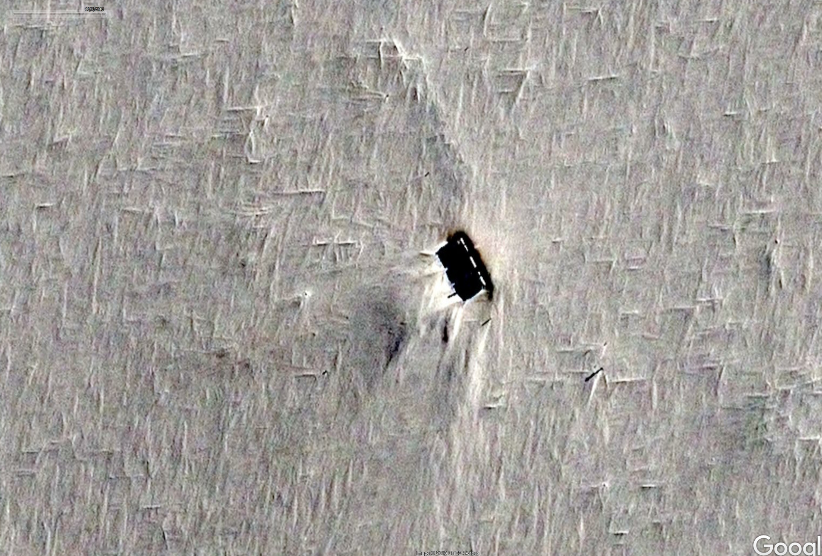
I think what is seen there is the station itself with the sun hitting it at very oblique angle so that it's casting a very long shadow.
If you look closely at the shadow, you can make out the gaps between the buildings and the hoist. What looks like three white dashes in a line (right side of feature) would be snow on the roofs.
The line of features below I would assume are from ice core drilling.
ETA:
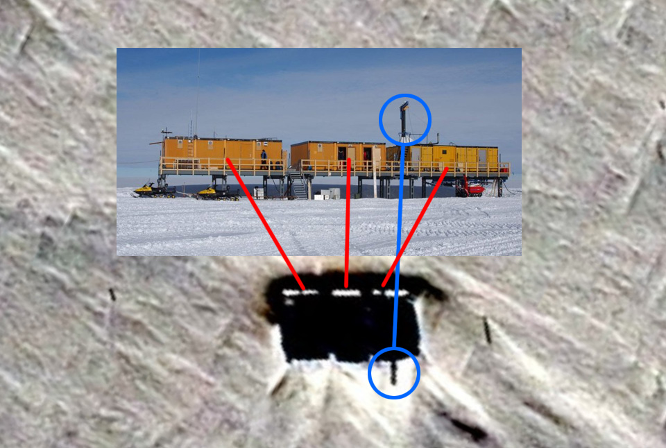
No problem. I looked up Queen Maud Land stations for a list and found this picture:
Kohnen looked about right so I checked out the Wikipedia page and saw the coordinates. If you look at this image again:
I think what is seen there is the station itself with the sun hitting it at very oblique angle so that it's casting a very long shadow.
If you look closely at the shadow, you can make out the gaps between the buildings and the hoist. What looks like three white dashes in a line (right side of feature) would be snow on the roofs.
The line of features below I would assume are from ice core drilling.
ETA:
edit on 2018-9-1 by theantediluvian because: (no reason given)
originally posted by: Xcathdra
originally posted by: KansasGirl
originally posted by: Xcathdra
originally posted by: KansasGirl
a reply to: Xcathdra
What about in 2018? Has anyone looked today? Surely some peeps on this site have Google Earth.....
I have google earth pro.. The latest image is from 2016.
I don't understand.
The most up to date image for the area in question was taken in 2016. If I load up google earth, even though it is Sep 1 2018, the image I am seeing of the area was the image from 2016.
Ah! Thank you.
a reply to: theantediluvian
Great! So we're looking at is the logistic base for a European ice coring project where there was a mass murder out on the ice- not inside any of the buildings- and the blood STILL hasn't been cleaned up.
Someone needs to tell the guy in the video that he was right, he DOES know his shades of red.
Great! So we're looking at is the logistic base for a European ice coring project where there was a mass murder out on the ice- not inside any of the buildings- and the blood STILL hasn't been cleaned up.
Someone needs to tell the guy in the video that he was right, he DOES know his shades of red.
originally posted by: Macenroe82
a reply to: Xcathdra
I have access to satellite data that is updated 3 times a day.
When I get in the office in the morning I’ll check those coordinates and send you some screen shots from what it looked like today
He'll yeah! That is really cool man, thanks!
new topics
-
Pelosi injured in Luxembourg
Other Current Events: 2 hours ago -
Nov 2024 - Former President Barack Hussein Obama Has Lost His Aura.
US Political Madness: 3 hours ago -
Something better
Dissecting Disinformation: 8 hours ago -
The Witcher IV — Cinematic Reveal Trailer | The Game Awards 2024
Video Games: 11 hours ago
top topics
-
They Know
Aliens and UFOs: 16 hours ago, 18 flags -
Pelosi injured in Luxembourg
Other Current Events: 2 hours ago, 9 flags -
Something better
Dissecting Disinformation: 8 hours ago, 8 flags -
Nov 2024 - Former President Barack Hussein Obama Has Lost His Aura.
US Political Madness: 3 hours ago, 7 flags -
More Ons?
Political Conspiracies: 12 hours ago, 6 flags -
Friday thoughts
General Chit Chat: 12 hours ago, 5 flags -
Canada Post strike ended by the Government of Canada
Mainstream News: 12 hours ago, 4 flags -
The Witcher IV — Cinematic Reveal Trailer | The Game Awards 2024
Video Games: 11 hours ago, 3 flags
active topics
-
-@TH3WH17ERABB17- -Q- ---TIME TO SHOW THE WORLD--- -Part- --44--
Dissecting Disinformation • 3671 • : duncanagain -
Something better
Dissecting Disinformation • 16 • : KrustyKrab -
Pelosi injured in Luxembourg
Other Current Events • 14 • : worldstarcountry -
President Biden to Grant Blanket Pardons to Individuals Trump's DOJ May Indict 2025-2029.
US Political Madness • 47 • : WeMustCare -
A Bunch of Maybe Drones Just Flew Across Hillsborough County
Aircraft Projects • 71 • : NoCorruptionAllowed -
Drones (QUESTION) TERMINATOR (QUESTION)
General Chit Chat • 11 • : Cavemannick -
Alien warfare predicted for December 3 2024
Aliens and UFOs • 115 • : WeMustCare -
They Know
Aliens and UFOs • 66 • : Springbok -
Biden pardons 39 and commutes 1500 sentences…
Mainstream News • 28 • : charlyv -
The Witcher IV — Cinematic Reveal Trailer | The Game Awards 2024
Video Games • 5 • : Hypntick