It looks like you're using an Ad Blocker.
Please white-list or disable AboveTopSecret.com in your ad-blocking tool.
Thank you.
Some features of ATS will be disabled while you continue to use an ad-blocker.

Cellular reception at Groom Lake
page: 15
share:
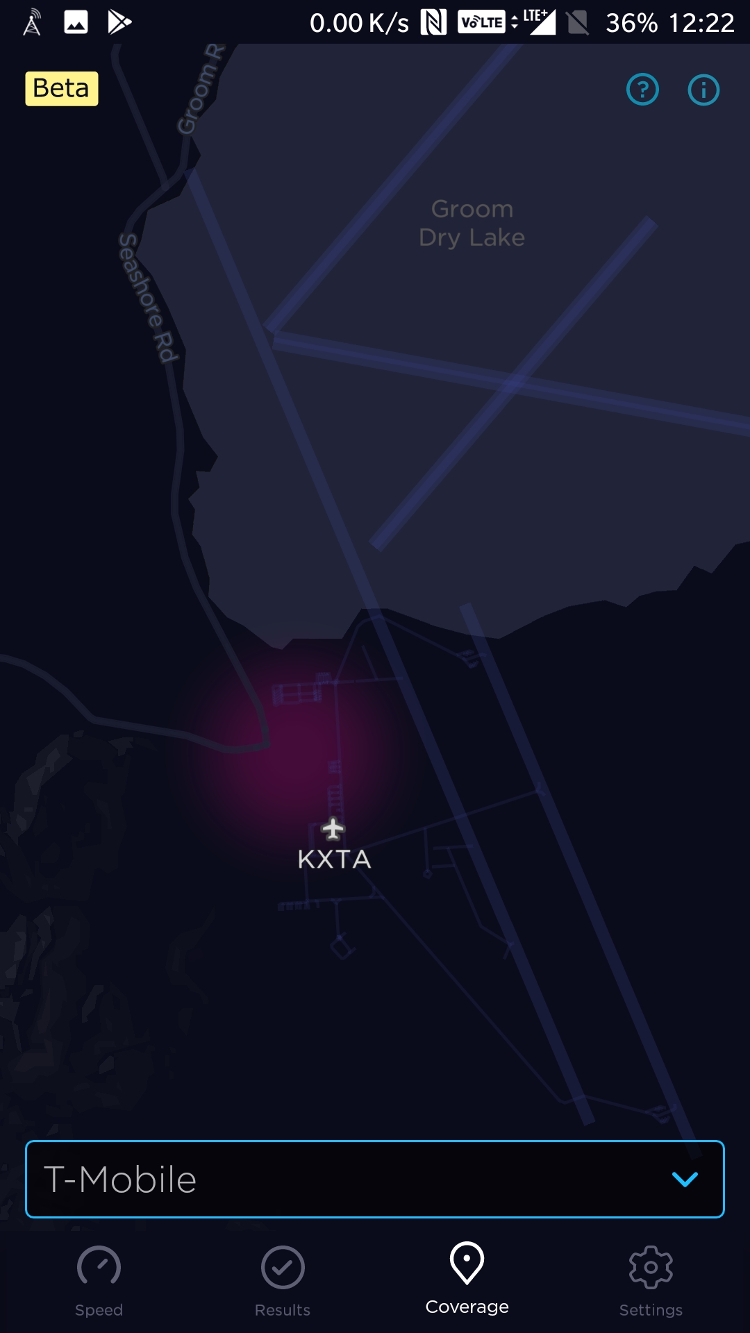
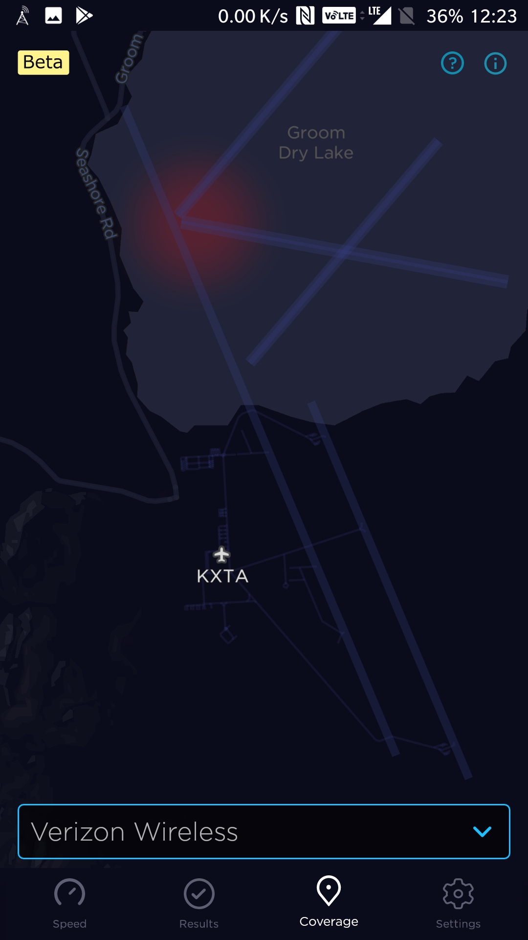
I suppose many people on the forum have an app on their phone called Speedtest. It is from Ookla. I noticed a beta feature in the app that provides a signal strength reception map of sorts. Emphasis on "of sorts" since there is no documentation on how this map is created. You can tell it uses Open Street Map based on the annotation used around Groom Lake.
The images I uploaded are for Verizon and Tmobile reception. There was nothing for AT&T. In classified areas, you don't get to bring your handy pocket spy machine AKA modern cell phone, so I am really suspicious that the indicated reception is real. Further I don't know if you actually had to be running a speed test for anything to be recorded.
Nevada Test Site employees have been allowed to carry cell phones for years. Back in the day, they had those Blackberry phones with no camera. There was a tag of sorts on the phone to indicate some power that be blessed the phone. I have no idea what the current rules are.
So at the moment, log this activity at Groom Lake as interesting but not an OPSEC failure like those fitness trackers.
BTW there is some sort of heat spot on the map between the civilian Tonopah Airport and the Tonopah Test Range. The map itself has no annotation at the location, though it could be the TTR man camp. I'm going to try to figure out the location later.
edit on 13-3-2018 by gariac because:
Grammar!
edit on 13-3-2018 by gariac because: Autocorrect!
Id assume they can bring their cell phones on the base but once they got to specific areas they probably have drop off points to prevent any security
violations. That’s my best guess based on my experiences, but we’re talking about one of the most secure bases in the world so who knows. As to
cell phone coverage, I’d assume they probably have a very limited network for very specific people.
edit on 13-3-2018 by amicktd because: (no
reason given)
Likely the government has there own cell site that is based on the StingRay system. and they record everything.
www.cato.org...
www.cato.org...
99.9% sure they cannot bring phones. they can call out to family if they need too. most family also has an emergency number to get them.
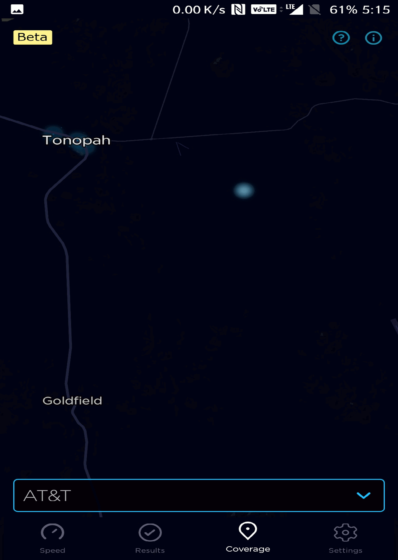
Calibrating the map, the blue dot south of the Tonopah civilian airport is n38 w117. This is known as a confluence point. Since this location is in free territory, it can be found on the Confluence web page:
N38 W117
While is is possible some geeks went to the confluence point and ran a speed test, it is more likely Ookla decided to map some test to this confluence point to give the tester some privacy.
The Groom Lake points are not at a confluence point.
new topics
-
Oklahoma mandates Bibles in public classrooms
Other Current Events: 7 hours ago -
Peter Santenello on YouTube.
Television: 10 hours ago
top topics
-
A woman met a group of migrants at a school bus stop. Then the story hit the internet
Social Issues and Civil Unrest: 17 hours ago, 8 flags -
Oklahoma mandates Bibles in public classrooms
Other Current Events: 7 hours ago, 8 flags -
Russian ambasador leaves the US
World War Three: 12 hours ago, 6 flags -
Is she trying to be The Joker ?
General Chit Chat: 13 hours ago, 5 flags -
Free Stays
Short Stories: 14 hours ago, 3 flags -
Peter Santenello on YouTube.
Television: 10 hours ago, 2 flags
active topics
-
TRUMP Loves America and Citizens So Much He is Returning to Where He Was Shot 3 Months Ago.
2024 Elections • 98 • : PorkChop96 -
How the U.S. Government is Failing to Protect Migrant Children from Trafficking and Abuse
Social Issues and Civil Unrest • 39 • : PrivateAngel -
Oklahoma mandates Bibles in public classrooms
Other Current Events • 41 • : chr0naut -
The Acronym Game .. Pt.4
General Chit Chat • 688 • : FullHeathen -
FEMA funding going to illegals - at least 650 million
US Political Madness • 39 • : tarantulabite1 -
Female is Not a Feeling
Rant • 120 • : hydr0cannibal -
A woman met a group of migrants at a school bus stop. Then the story hit the internet
Social Issues and Civil Unrest • 68 • : whereislogic -
V.P. Candidate J.D. VANCE declares President Donald Trump WON Re-election in 2020.
2024 Elections • 61 • : 777Vader -
Does Israel have anything left to lose at this point?
War On Terrorism • 60 • : anned1 -
After Kamala Harris Loses the 2024 Election to Donald Trump - The Unrest Will Be Minimal.
2024 Elections • 35 • : WeMustCare
5