It looks like you're using an Ad Blocker.
Please white-list or disable AboveTopSecret.com in your ad-blocking tool.
Thank you.
Some features of ATS will be disabled while you continue to use an ad-blocker.

A question: What did the Inca build?
page: 2share:
originally posted by: BlubberyConspiracy
a reply to: Hanslune
The underlying and common theme for the reason Brien forester refuses to believe that ANY of these megaliths, Egyptian or South American were done by natives is because he doesn't believe they were CAPABLE of it.
Wrong, In regards to the Peruvian/Bolivian sites he has often spoken a Ancient Native people now extinct.
It's eerie, in the undertone of Brien's comments he seems to be constantly discrediting civilizations as less than capable because they were brown people
Wrong again, You seem to be interjecting your own angle and attributing it to him.
Watch all his shorts and see his urgency on why it can't possibly be the indigenous civilizations, it's subtle but omnipresent trait in most of his reasoning
The 'Ancient builders' he speculates on were indigenous. Just possibly preceding the Incas.
While he brings up a few good points on how earlier more advanced civilizations may have placed these relics, his primary concern is making sure that the indigenous people don't get credit. Rather than clarifying the issue on WHO and WHEN.
Wow, you really have it in for him and seem desperately trying to portray him *Poorly I might add* as some sort of racist. I hope you can sleep well at night. In any case these sites should be fully explored and analyzed, No? If they are shown to be completely 100% attributable to the Incas then the question of age and and origins would be settled.
Judge for yourself though, I tried to brush off his reasoning for a while however it seems too constant as if he's out there to say that megaliths couldn't be build by African or South American people because they were Africans and South Americans.
I'd love for you to quote him using the terms and language you're attributing to him.
Please.
edit on 19-9-2014 by SLAYER69 because: (no reason given)
a reply to: LABTECH767
Thanks for posting the images however, you're mixing two entirely different locations and possible cultures, The Amazon is in South America and the Olmec are from Central America *thousands of miles apart and are not related.
The images from the Amazon area are quite interesting, The Earliest of Spanish explorers of the River claimed there were huge populations living in 'Cities" along the river. The term 'Cities' should be considered in the context of large villages as opposed to stone walls and pyramids etc. The tales were often dismissed because similar exploration some 80 or so years later didn't find any evidence or sign of large populations. When I first read such accounts I thought they were simply exaggerations then later upon thinking about it a bit more I came to the conclusion that the Earliest Spanish explorers themselves spread disease which wiped out those large populations, so it wouldn't be surprising that the follow on explorers didn't find much in the way of evidence.
80 or so years is more than enough of time for the fast growing Amazonian jungle to swallow up any signs of villages/farms etc, never mind it now being over 400+ odd years later.
So, still, The idea of a large Amazonian population was dismissed until fairly recently.
Ancient Amazon Cities Found; Were Vast Urban Network
Dozens of ancient, densely packed, towns, villages, and hamlets arranged in an organized pattern have been mapped in the Brazilian Amazon, anthropologists announced today.
The finding suggests that vast swathes of "pristine" rain forest may actually have been sophisticated urban landscapes prior to the arrival of European colonists.
"It is very different from what we might expect using certain classic models of urbanism," noted study co-author Michael Heckenberger, an anthropologist at the University of Florida in Gainesville.
Nevertheless, he said, the repeated patterns within and among settlements across the landscape suggest a highly ordered and planned society on par with any medieval European town.
The finding supports a controversial theory that the Amazon River Basin teemed with large societies that were all but obliterated by disease when European colonists arrived in the 15th and 16th centuries.
edit on 19-9-2014 by SLAYER69 because: (no reason given)
a reply to: LABTECH767
I apologize I missed the last of your post.
I believe the Maya borrowed heavily from the Olmec who preceded them in Math, writing, architecture etc.
The Olmec are very interesting to me because it seems that there again we find that at their earliest stages and locations we find excellently carved stonework that show signs of damage as if they were re-purposed from an earlier site/temple/what have you that was destroyed in a much earlier period and then later placed in locations of veneration.
[atsimg]http://files.abovetopsecret.com/images/member/1648882e514d.jpg[/atsimg]
[atsimg]http://files.abovetopsecret.com/images/member/16d86ead36e4.jpg[/atsimg]
[atsimg]http://files.abovetopsecret.com/images/member/9c4181601cea.jpg[/atsimg]
[atsimg]http://files.abovetopsecret.com/images/member/d597cef7aa7f.jpg[/atsimg]
[atsimg]http://files.abovetopsecret.com/images/member/e5dd49c09dc6.jpg[/atsimg]
[atsimg]http://files.abovetopsecret.com/images/member/df7a0bd0b9fa.jpg[/atsimg]
I apologize I missed the last of your post.
Though I tend to believe they were probably a contemporaneous culture to the Olmec or even maya who also Cleared forest for agricultural purposes.
I believe the Maya borrowed heavily from the Olmec who preceded them in Math, writing, architecture etc.
The Olmec are very interesting to me because it seems that there again we find that at their earliest stages and locations we find excellently carved stonework that show signs of damage as if they were re-purposed from an earlier site/temple/what have you that was destroyed in a much earlier period and then later placed in locations of veneration.
[atsimg]http://files.abovetopsecret.com/images/member/1648882e514d.jpg[/atsimg]
[atsimg]http://files.abovetopsecret.com/images/member/16d86ead36e4.jpg[/atsimg]
[atsimg]http://files.abovetopsecret.com/images/member/9c4181601cea.jpg[/atsimg]
[atsimg]http://files.abovetopsecret.com/images/member/d597cef7aa7f.jpg[/atsimg]
[atsimg]http://files.abovetopsecret.com/images/member/e5dd49c09dc6.jpg[/atsimg]
[atsimg]http://files.abovetopsecret.com/images/member/df7a0bd0b9fa.jpg[/atsimg]
edit on 19-9-2014 by SLAYER69 because: (no reason
given)
I put up a thread of Guitarrero cave one of the best early Peruvian sites
Guitarrero Cave
originally posted by: BlubberyConspiracy
As noted by Slayer it might be helpful to post some examples of BF's writings to support this.
My own understanding of his stance is
From one of his books; Lost Ancient Technology Of Peru And Bolivia
So from this one example he is dismissing the Inca culture and substituting another unknown one that existed in Peru and Bolivia however I think he also holds that this same culture was also in Egypt and world wide, so not quite 'native'. He also holds the view that the elongated human skulls are actually aliens or some such and they were the builders but he does label that as speculation.
Guitarrero Cave
originally posted by: BlubberyConspiracy
As noted by Slayer it might be helpful to post some examples of BF's writings to support this.
My own understanding of his stance is
From one of his books; Lost Ancient Technology Of Peru And Bolivia
Brien Foerster shows you that places such as Cusco, Puma Punku, Tiwanaku and even Machu Picchu were initially constructed thousands of years before the Inca or other famous people existed. Mounting scientific evidence shows that prior to the end of the Ice Age, 12,000 years ago, very advanced cultures existed in Peru and Bolivia, and had advanced high technology.
So from this one example he is dismissing the Inca culture and substituting another unknown one that existed in Peru and Bolivia however I think he also holds that this same culture was also in Egypt and world wide, so not quite 'native'. He also holds the view that the elongated human skulls are actually aliens or some such and they were the builders but he does label that as speculation.
edit on 19/9/14 by Hanslune because: (no reason
given)
a reply to: SLAYER69
You brought the Olmec back up and they are one of the most enigmatic society's, it just made me remember this.
www.luismarianofernandez.com...
If you speak spanish then it is not a problem but if you don't google translate as it is well worth the read of these four pages, he also brings the Olmec sphynx like statues into the question.
It sound's as if those city's along the river did probably succumb to european virus and bacteria to which they had no immunity at all so maybe these markings are recent after all, relatively speaking as in from that period of the early to mid 1500's, even when we do not resort to war our presence can still be destructive but there is a theory that Syphilus originated in the america's and was introduced to europe and the rest of the world by those early transatlantic navigator's.
When you look at how small the nina pinta and santa maria were it is astounding they made it at all and it is worth remembering that columbus is quoted as having mentioned masted and oared ships as big as his vessels sailing between the island we today call cuba and the land further west which he actually thought was the orient at first so our view of the meso-american culture's alway's overlooks there maritime skill's and the possibility that perhaps they once traded with africa and maybe some as far as egypt which may have inspired the olmec style as well as explaining the infamous narcotic traces in some egyptian mummie's, perhaps that trade was lost when new plagues swept the old world and killed off the sailors before there ships could return to there home port's, those ports were appropriated by the spaniards when they conquered.
edit on 19-9-2014 by LABTECH767 because: (no reason given)
a reply to: LABTECH767
Hey Labtech
Seems more an article about the Cuban site also I didn't find any mention of sphinxes.....oh wait found it.
Is this the quote you were thinking of?
Hey Labtech
Seems more an article about the Cuban site also I didn't find any mention of sphinxes.....oh wait found it.
Parts stored in a major Mexican museum. Archaeologists located in the unknown Olmec civilization . Did you have any relationship with the Egyptian culture since the similar style
Is this the quote you were thinking of?
a reply to: Hanslune
I knew it would make you laugh but you have to admit it is worth a read even if the source is not up to your standard's and still intriguing, I never remember but apparently Paulina Zelitsky went back on a return expedition in 2004 but they only photographed the pyramid structure before there ROV started to malfunction and they had to call off the expedition, but then though I do believe it to be a city ruin despite the depth being more than double that of the glacial maximum of the ice age (when no city is supposed to have existed anywhere) the russians may have tried to construct an alternative to the cuban land based missile structures (though this is even more far fetched than the city idea as they probably did not have that capability in that region at that time though let's be fair, tell a texan oil baron there is oil there and he will build whatever he has to, to get it) so there has to be a geological process involved and I tend toward the Tilting continent theory.
www.australiangeographic.com.au...
At one time the rivers in the Amazon basin would have flowed west before the rising of the andean range (Which is still rising today) and as the south american plate rides over the older crustal pacific plate (that is a thick plate despite being basaltic) the mechanism creates lift as well as crumple zones and mountain formation on the western sea board of south america but also as it rides further over the older plate it also tilt's the west up and the east side well that is pushed by the young and thin atlantic plate with no underlying plate to resist it and is pushed down by this sea saw motion.
Of course just like earthquakes such geological motion can sometimes happen quickly as well as gradually but can also be a rocking rather than a sinking as the plate will eventually right itself to some degree as it passes over more of the pacific plate which itself may have varying density's.
edit on 19-9-2014 by LABTECH767 because: (no reason given)
a reply to: LABTECH767
Howdy
Not sure how you are relating the tilt theory with the Cuban site as that process ended about 14 million years ago. the Cuban site is also on a different plate, the north American plate, or are you suggesting a similar 'tilting' in recent times to the NAP as happened to the SAP millions of years ago?
All interesting stuff but we seemed to be going off topic!
Howdy
Not sure how you are relating the tilt theory with the Cuban site as that process ended about 14 million years ago. the Cuban site is also on a different plate, the north American plate, or are you suggesting a similar 'tilting' in recent times to the NAP as happened to the SAP millions of years ago?
Geoscientists from the University of Sydney and the California Institute of Technology believe a process called 'continental tilting', which began about 30 million years ago and continued for about 16 million years, tipped South America like a see-saw and drained its wetlands.
All interesting stuff but we seemed to be going off topic!
a reply to: Hanslune
Ah but the geological process did not end about 14 million years ago, indeed as continental drift (AKA plate techtonics) is still going on and indeed may continue as long as there is an earth for it to happen on there is no reason to believe our seemingly stable geological present is any more than a calm at the eye of the storm, personally I would love nothing more than for it to be 14 million years of age as it would validate one of my cherished belief's but would put into question weather it was the human species that had built it but I actually think it is within the past 14000 years and more likely within the more recent end of that time spectrum, I actually think a lot of the flood myths and legend's that are held by so many disparate groups around the world could be explained by such an episode.
For example, if the continent tilt happened then vast area's of land to the east of the present shore line would in those regions affected have been drowned and perhaps by a considerable amount of depth while lands to the east would have been upthrust (if it happened catastrophically quickly though a sudden fault shift it could also have caused a massive tsunami type event perhaps miles high waves racing across the ocean), now I know the Tiwanaku (TiaHuanaco) and Puma Punku ruins have been explained as recent though that is still in debate amongst many factions of believers and disbelievers but a very large number of species found in lake Titicaca itself are very closely related to species found in the salt water environment off the coast hundred's of miles to the west and at much lower altitude?, this could only have happened if the lake was originaly a trapped fjord bay that was isolated by the uplift of that that region, the only other possible colonization method is swimming up river's but that would require an adapted fresh water tollerant species to start with which the sea level fauna are not, now if the lake underwent slow desalination then it is possible that given enough time these species were able to adapt to there new environment, of course this would posit interesting question's about much of the region to the west and it's original altitude prior to this uplift, as you know the andes are still rising though they are estimated to be about 20 million years old and there rise caused a climactic change to the south american continent that for instance may have speeded the demise of many species including the massive and perhaps largest ever bird that once lived to the sough in what is today argentina and was large enough to carry a bull off in it's talon's.
Note the story about the shoreline water mark that is tilted, the submerged ruins in the lake etc, these show that if the site is only 1700 years old then it is incredible geologically active over the entire region.
So no the process did not end at all and is still ongoing, the presence of for example of sea horse in the lake proves that prior to it's uplift it was actually a bay or inlet of the sea and far more concise than C14 dating would be if anyone was willing to undertake it a genetic analysis of the mitochondrial DNA of the Sea Horse and a comparison for genetic drift to the closest Genus now found off the sea coast.
After studying it for 50 years maybe posnanski is correct.
www.ancient-wisdom.co.uk...
I would also point out that not only continental tilting can result in greater submersion than ice age minimum sea level rise but also sub crustal equalization, remember when the Ice caps' were formed to the north they were like an entire 8th continent pushing down on the crust, when the glacial maximum retreated the geological pressure fell and increased pressure displaced around that previous high pressure zone was also allowed to start to re equalize away from the regions to the south as it flowed by under the now light crust of the northern hemisphere, this process may have also resulted in cataclysmic earth quakes as the pressure shifts on fault line and even caused the crustal plate itself to have fallen south of the ice compressed regions as the ice pressure was reduced (Couple this with the increased downward pressure of all that water in the ocean crust as it melted back into the ocean) and maybe also resulted in a second cause of continental altitude loss in some regions, meaning the sea level in those regions would today be far greater relative to the previous Glacial Maximum than sea level equalization alone would suggest (as a rough example make a porrige with a crust, then put your spoon flat on top and notice how the region around it rises, take the spoon away and look how it returns to the previous level or near enough to it), now several ice age maximum's have occured over the past 5 million years and several ice age minimum's, this means the pressure has been back and forth but we believe the last ice age was perhaps one of the larger maximums.
If you could see some of the northern mountain ranges prior to this period such as the northern rocky's or the alps you would see a far more impressive altitude to what they now have, not simply through the process of the ice erosion but also add to it the downward pressure on the mantle of the extra mass of the ice that covered them and even more altitude variance can be added, if we could see the climates of regions back then before the ice ages we would see a vast difference in climate and totally different ecosystems on either side of these ranges just as we do with the himalayas today.
Of course the ice was like a vast cloth in the hand of a fat teacher (with bad coffee breath) rubbing the black board clean in the northern hemisphere so any ancient ruins that survived from a non global age of primitive (ie not like today) civilizations would be found just where these ruins are south of the ice, however carbon dating thow's a spanner into that but is it correct as even under stones the samples analyzed could have been deposited by water action or biological activity such as plant root and growth at a later date, were enough samples taken or was the process of those making the analysis correct and without bias in there choice of sample specimen and were enough samples collated, we all know the coso geode fiasco were the opposite side of this arguement happened in that a concretion containing ancient material was analyzed but that concretion had formed around an early 1920's champion spark plug that had probably been discarded from the nearby mine generator's which shows that at best C14 dating is not reliable and a better analysis would of isotopic ratios would have been to analyse the Argon Krypton dating from areas between stones that have the least weathering but have been exposed to the atmosphere though that would possibly be thown out a little by the altitude and atmospheric composition at the site.
edit on 20-9-2014 by LABTECH767 because: (no reason given)
originally posted by: LABTECH767
a reply to: Hanslune
Ah but the geological process did not end about 14 million years ago,
Ah but the paper said that tilting did end but of course not plate techtonics general movement - as you note below
Note the story about the shoreline water mark that is tilted, the submerged ruins in the lake etc, these show that if the site is only 1700 years old then it is incredible geologically active over the entire region.
Deleted a lot of stuff but yes the collision of two plates have produced the Andes and creatures have evolved in lake T.
C14 dating would be if anyone was willing to undertake it a genetic analysis of the mitochondrial DNA of the Sea Horse and a comparison for genetic drift to the closest Genus now found off the sea coast.
That would be a good study to campaign for
After studying it for 50 years maybe posnanski is correct.
After studying the Posnansky problem for a few hours (long ago) I concluded he was very wrong
Posnansky assumed that the temples at Tiwanaku was laid out with perfect accuracy to align to the equinoxes and solstices that he felt were important to the Tiwanaku people, he of course had no idea what was actually important to to them
Thus, on a certain day the sun was supposed to rise above one rock at the temple and set behind another – ah, but which rock should we choose? Since the current ruins do not align with these celestial events accurately, he concluded that the ruins must have been built at a time when they would have aligned with that event.
Since the sun and sky change positions at a predictable rate due to gradual changes in the angle of the earth’s axis, he concluded that temple was built in 13,000 BCE as a solar observatory, despite no other evidence of solar astronomy at the site.
The long and short of it is that Posnansky assumed celestial alignments and assumed flawless construction and then used his assumptions to “prove” that his assumptions were correct. While the reality was that the site was very disturbed by both man and nature.
“Pick a rock, any rock. One of them must align with something”. One doesn't blame Posnansky without any other method of dating his was inspired guess.
snipped a large bunch of material that seemed to be saying C-14 dating was unreliable
Its as reliable as the sources, method of use, and limitations allow. it is especially useful when associated with other methods of dating.
Thanks for the long reply - I only have a basic knowledge of geology so I did not reply to those parts.
a reply to: Hanslune
Fair enough so Posnansky approached the matter with a pre concieved notion and forced what he observed to fit that notion, something we are all guilty of, still I find the story of the sunken temple in the far end of the lake that is in deep water with steps and a road going off even deeper and the tilted water line around the lake telling as it would suggest the region tilted geologically recently within the period of human habitation and that would have been cataclysmic for any one living there perhaps even leading to the downfall of that culture who built these site's and maybe coupled with a terrible earth quake would posit a possible explanation for the huge stones of Puma Punku being thrown around like a childs building blocks or so they have been described.
The only real way of knowing though would be to get Cameron to mount an expedition to the lost city with his film crew but there may be real cold war reasons why Cuba might not allow that and even if it is as I believe a city there may be sensitive matters down there the Cubans do not want anyone finding including a Russian Sosus net to track US naval movement's located around Cuba for example or submarine silo's.
edit on 20-9-2014 by LABTECH767 because: (no reason given)
originally posted by: LABTECH767
still I find the story of the sunken temple in the far end of the lake that is in deep water with steps and a road going off even deeper and the tilted water line around the lake telling as it would suggest the region tilted geologically recently within the period of human habitation
I have not heard of a water line before do you have a link?
The only real way of knowing though would be to get Cameron to mount an expedition to the lost city with his film crew but there may be real cold war reasons why Cuba might not allow that and even if it is as I believe a city there may be sensitive matters down there the Cubans do not want anyone finding including a Russian Sosus net to track US naval movement's located around Cuba for example or submarine silo's.
Considering they let in previous expeditions I cannot imagine why they would now get antsy about it.
They could very easily use Venezuelan teams and Russian equipment.
a reply to: Hanslune
Fair observation on that, but it would still be prohibitively expensive, the water mark is on this page www.ancient-wisdom.co.uk... though I have read about it before.
Under the section marked Tiahuanaco Other Points of Interest.
Here is an excerpt
On the rock cliffs near the piers and wharfs of the port area are yellow-white calcareous deposits forming long, straight lines indicating pre-historic water levels. These ancient shorelines are strangely tilted, although once they must have been level. Athough the lake averages between 460 and 600 feet (140 and 180 m) in depth, but the bottom tilts sharply toward the Bolivian shore, reaching its greatest recorded depth of 920 feet (280 m) off Isla Soto in the lake's northeast corner.
And another
"we can now say that the existence of pre-Columbian constructions under the waters of Lake Titicaca is no longer a mere supposition or science-fiction, but a real fact. Further," he added, 'the remnants found show the existence of old civilizations that greatly antecede the Spanish colonization. We have found temples built of huge blocks of stone, with stone roads leading to unknown places and flights of steps whose bases were lost in the depths of the lake amid a thick vegetation of algae." Boero Rojo described these monumental ruins as being "of probable Tiahuanaco origin.
originally posted by: LABTECH767
a reply to: Hanslune
Here is an excerpt
On the rock cliffs near the piers and wharfs of the port area are yellow-white calcareous deposits forming long, straight lines indicating pre-historic water levels. These ancient shorelines are strangely tilted, although once they must have been level. Athough the lake averages between 460 and 600 feet (140 and 180 m) in depth, but the bottom tilts sharply toward the Bolivian shore, reaching its greatest recorded depth of 920 feet (280 m) off Isla Soto in the lake's northeast corner.
Distortion of strata is very common especially in geologically active spots. Where did this comment come from, ie the scientific paper? I'm wondering why the age of this 'tilted' section is not noted.
And another
"we can now say that the existence of pre-Columbian constructions under the waters of Lake Titicaca is no longer a mere supposition or science-fiction, but a real fact. Further," he added, 'the remnants found show the existence of old civilizations that greatly antecede the Spanish colonization. We have found temples built of huge blocks of stone, with stone roads leading to unknown places and flights of steps whose bases were lost in the depths of the lake amid a thick vegetation of algae." Boero Rojo described these monumental ruins as being "of probable Tiahuanaco origin.
The Titcaca drill
project
In the above they went down into the sediments down to 370,000 years into the past.
Here are the results

You can see that salt content and other factor constantly changed due to weather, it was once much fresher and is now relatively brackish.
a reply to: Hanslune
I noticed by your chart that at or around 10,000 BCE the levels dropped for a few thousand years and have recently *In Geological terms* have risen again.
I've been toying with a theory on that and IF, Major if there, IF, the site is as old as Posnansky suggests/theorizes then we may be able to answer two questions at once. I've often wondered if during the ice age, as was the case in North America, that the Andes may have also had melt off and a location above the area where an Ice damn may have held back a large melt off and created a fresh water lake which may have given way and not only flooded the Lake which would have diluted it's salt level but also may have washed over the Ancient monuments and creating the jumble of stones.
This of course would depend on IF the site were truly that old and IF such evidence of a flood had occurred in the past.
More recently the oldest site yet Discovered. Caral Supe, some of the ancient construction appears to have been partially washed away on the left of this image. [atsimg]http://files.abovetopsecret.com/images/member/806948a8a0c4.jpg[/atsimg]
If it wasn't partially washed away by run off from the Andes then when did the area in question have a much wetter climate?
edit on 20-9-2014
by SLAYER69 because: (no reason given)
a reply to: SLAYER69
Good speculation Slayer.
To your last comment on Caral as I recall the Rio Supe (an intermittent river with known flood problems**) runs right by the site and yes it looks like part of the site has been washed away.
**Spanish language site - translated by googleRio supe control plan
First part: to show destruction by flooding you need a good 'scatter' diagram of the site, a look down chart that plots the various pieces. If it were destroyed by water the plot should show a common direction of movement with lighter pieces being further away. If by earthquake a small CEP and if by man, random.
Here is an example of an artifact scatter diagram or plot
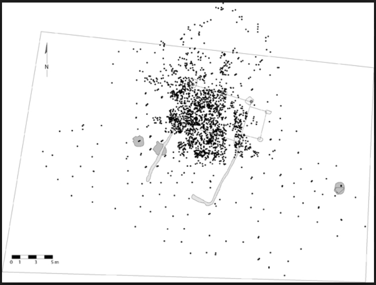
it shows where every artifact is found in relationship to a specified central point. They are used for many purposes but I used them to plot pottery finds and we tended to find bronze age settlements at the center of such plots.
Good speculation Slayer.
To your last comment on Caral as I recall the Rio Supe (an intermittent river with known flood problems**) runs right by the site and yes it looks like part of the site has been washed away.
**Spanish language site - translated by googleRio supe control plan
First part: to show destruction by flooding you need a good 'scatter' diagram of the site, a look down chart that plots the various pieces. If it were destroyed by water the plot should show a common direction of movement with lighter pieces being further away. If by earthquake a small CEP and if by man, random.
Here is an example of an artifact scatter diagram or plot
it shows where every artifact is found in relationship to a specified central point. They are used for many purposes but I used them to plot pottery finds and we tended to find bronze age settlements at the center of such plots.
edit on 20/9/14 by Hanslune because: (no reason given)
a reply to: SLAYER69
Elegant theory, at that altitude with lower global climactic temperatures the andean glaciers would undoubtedly have been larger but by how much, still such a mechanism would be able to introduce younger C14 containing material than the site would otherwise have had.
Other methods could be a higher lake that an earthquake released but satellite images of the area shoud still show that lake bed and the altiplana is huge, the entire area is a inland sea or lake bed that has desalinated over time though fresh water flowing in and the surrounding topography would seem not to support the idea, however an ice damn may be a possibility, there should be scarring on the land from the area that the damn broke though so a look at google earth may show such.
Scratch that Hanslune has provided the most likely solution to at least those areas bordering that river.
This is an interesting old page on the site, the ideas are dated and seem primitive to our mind's but back when they originated they were more acceptable.
fallencreature.wordpress.com...
edit on 20-9-2014 by LABTECH767 because: (no reason given)
For hard core Inca rock fans
Here are three interesting pieces of work:
Slithering Serpents and the Afterlives of Stones: The Role of Ornament in Inka- Style Architecture of Cusco, Peru
Power in Stone: The Long-Distance Movement of Building Blocks in the Inca Empire Ethnohistory Winter 2004 51(1): 101-135
I could not find a source of this not behind a pay wall but have asked at another site to see if anyone has access to it.
The third one is a book that goes deeply into how the Inca view rocks from the mystical side and how they view masonry and the buildings they made
A Culture of Stone: Inka Perspectives on Rock, Duke University Press, 2010
ISBN 9780822393177, By Carolyn Dean
Here are three interesting pieces of work:
Slithering Serpents and the Afterlives of Stones: The Role of Ornament in Inka- Style Architecture of Cusco, Peru
Power in Stone: The Long-Distance Movement of Building Blocks in the Inca Empire Ethnohistory Winter 2004 51(1): 101-135
Abstract
This article analyzes the objectives and implications of the long-distance transport of building blocks in the Inca Empire. Recent research has demonstrated that the Incas transported building stones from Cuzco, Peru, to Saraguro, Ecuador, much as described by the Spanish chronicler Martín de Murúa. Additional passages from sixteenth- and seventeenth-century chronicles suggest that the Incas carried out a number of such projects to bring stones from Cuzco to the northern part of the empire. These stones embodied the transfer of sanctity and power from the imperial capital to the city of Tomebamba in Ecuador, while their movement was a major public demonstration of state control over labor.
I could not find a source of this not behind a pay wall but have asked at another site to see if anyone has access to it.
The third one is a book that goes deeply into how the Inca view rocks from the mystical side and how they view masonry and the buildings they made
A Culture of Stone: Inka Perspectives on Rock, Duke University Press, 2010
ISBN 9780822393177, By Carolyn Dean
A major contribution to both art history and Latin American studies, A Culture of Stone offers sophisticated new insights into Inka culture and the interpretation of non-Western art. Carolyn Dean focuses on rock outcrops masterfully integrated into Inka architecture, exquisitely worked masonry, and freestanding sacred rocks, explaining how certain stones took on lives of their own and played a vital role in the unfolding of Inka history. Examining the multiple uses of stone, she argues that the Inka understood building in stone as a way of ordering the chaos of unordered nature, converting untamed spaces into domesticated places, and laying claim to new territories. Dean contends that understanding what the rocks signified requires seeing them as the Inka saw them: as potentially animate, sentient, and sacred. Through careful analysis of Inka stonework, colonial-period accounts of the Inka, and contemporary ethnographic and folkloric studies of indigenous Andean culture, Dean reconstructs the relationships between stonework and other aspects of Inka life, including imperial expansion, worship, and agriculture. She also scrutinizes meanings imposed on Inka stone by the colonial Spanish and, later, by tourism and the tourist industry. A Culture of Stone is a compelling multidisciplinary argument for rethinking how we see and comprehend the Inka past.
This photo, taken near the Wiracocha Temple in the Sacred Valley Peru, begs the question -
if the wall is Inca then where did they get the 2 (obviously older) stones at the bottom from?
Well I think the answer obviously has to be from an older more technically advanced civilization.
if the wall is Inca then where did they get the 2 (obviously older) stones at the bottom from?
s9.postimg.org...
Well I think the answer obviously has to be from an older more technically advanced civilization.
edit on 22-9-2014 by JamesTB because: fix link
a reply to: JamesTB
How is it "obvious" that it HAD to have come from an earlier more technologically advanced civ? The picture give absolutely zero context to the entirety if the structure. It's the photographic equivalent I quote mining. It gives no information beyond that which is necessary to show your own point if view in the light you wish it to be shown. It's not terribly scientific and there's certainly not enough information there to make any type of statement one way or the other based solely on the context you have provided. It reeks of confirmation bias.
How is it "obvious" that it HAD to have come from an earlier more technologically advanced civ? The picture give absolutely zero context to the entirety if the structure. It's the photographic equivalent I quote mining. It gives no information beyond that which is necessary to show your own point if view in the light you wish it to be shown. It's not terribly scientific and there's certainly not enough information there to make any type of statement one way or the other based solely on the context you have provided. It reeks of confirmation bias.
new topics
-
Magic Vaporizing Ray Gun Claim - More Proof You Can't Believe Anything Hamas Says
War On Terrorism: 17 minutes ago -
One out of every 20 Canadians Dies by Euthanasia
Medical Issues & Conspiracies: 26 minutes ago -
USS Liberty - I had no idea. Candace Owen Interview
US Political Madness: 1 hours ago -
What Am I Hearing
General Chit Chat: 9 hours ago
top topics
-
A Bunch of Maybe Drones Just Flew Across Hillsborough County
Aircraft Projects: 15 hours ago, 9 flags -
USS Liberty - I had no idea. Candace Owen Interview
US Political Madness: 1 hours ago, 5 flags -
Who's coming with me?
General Conspiracies: 16 hours ago, 4 flags -
What Am I Hearing
General Chit Chat: 9 hours ago, 2 flags -
Magic Vaporizing Ray Gun Claim - More Proof You Can't Believe Anything Hamas Says
War On Terrorism: 17 minutes ago, 2 flags -
One out of every 20 Canadians Dies by Euthanasia
Medical Issues & Conspiracies: 26 minutes ago, 1 flags
active topics
-
USS Liberty - I had no idea. Candace Owen Interview
US Political Madness • 2 • : chiefsmom -
Remember when Iraq invaded Kuwait
History • 28 • : LSU2018 -
Magic Vaporizing Ray Gun Claim - More Proof You Can't Believe Anything Hamas Says
War On Terrorism • 0 • : FlyersFan -
And Here Come the Excuses!!
General Conspiracies • 183 • : Xtrozero -
What Am I Hearing
General Chit Chat • 10 • : charlest2 -
Who's coming with me?
General Conspiracies • 39 • : LSU2018 -
One out of every 20 Canadians Dies by Euthanasia
Medical Issues & Conspiracies • 0 • : FlyersFan -
You Will Have Covid Shot And Be Unhappy
Medical Issues & Conspiracies • 40 • : mysterioustranger -
A Bunch of Maybe Drones Just Flew Across Hillsborough County
Aircraft Projects • 22 • : LSU2018 -
Post A Funny (T&C Friendly) Pic Part IV: The LOL awakens!
General Chit Chat • 7900 • : baddmove