It looks like you're using an Ad Blocker.
Please white-list or disable AboveTopSecret.com in your ad-blocking tool.
Thank you.
Some features of ATS will be disabled while you continue to use an ad-blocker.

Severe Weather Outbreaks 2014
page: 12share:
a reply to: TXTriker
waiting for 00utc models will update
nam is only 12 hrs out here is the latest images 12 hrs
www.instantweathermaps.com...
waiting for 00utc models will update
nam is only 12 hrs out here is the latest images 12 hrs
www.instantweathermaps.com...
edit on 27-4-2014 by TechniXcality
because: (no reason given)
originally posted by: TechniXcality
a reply to: TXTriker
waiting for 00utc models will update
nam is only 12 hrs out here is the latest images 12 hrs
www.instantweathermaps.com...
So that is where they are supposed to be in the next 12 hours? Sorry, not really intelligent about the maps but definitely willing to learn.
originally posted by: TXTriker
originally posted by: TechniXcality
a reply to: TXTriker
waiting for 00utc models will update
nam is only 12 hrs out here is the latest images 12 hrs
www.instantweathermaps.com...
So that is where they are supposed to be in the next 12 hours? Sorry, not really intelligent about the maps but definitely willing to learn.
Every map I look at is slightly different... I am having a hard time figuring out which is LIVE vs. which is a forecast over the next couple of days. I appreciate this thread!
a reply to: TechniXcality
We love you too Tech & God Bless you.
Thanks for keeping us updated. Stay safe!!!!
We love you too Tech & God Bless you.
Thanks for keeping us updated. Stay safe!!!!
edit on 27-4-2014 by MrLimpet because: (no reason given)
a reply to: TXTriker
ok so here is your conversions( weatherarc.com...)the 00utc model comes out at 700pm eastern time
here is the model hour (mag.ncep.noaa.gov... Guidance&preselected_formatted_cycle_date=20140428 00 UTC&area=namer&cycle=00&fhr=015¶m=500_vort_ht|1000_500_thick|700_rh_ht|850_temp_ht&ps=area&size=medium) this is at 15utc so 10am eastern Monday, I hope this explains and will continue to watch models so I can further answer your question
sorry correction the 15utc model wasn't ready here is the 12utc model they represent 3hr intervals. so they never represent current observation but instead the last 3 hrs this stipulation becomes important when tracking winter storms because it can mean the difference between snow and rain..
mag.ncep.noaa.gov... am&area=namer&cycle=00¶m=500_vort_ht%7C1000_500_thick%7C700_rh_ht%7C850_temp_ht&fhr=012&group=Model+Guidance&preselected_formatted_cycle_date=2014 0428+00+UTC&ps=area&scrollx=0&scrolly=0
edit on 27-4-2014 by TechniXcality because: (no reason given)
edit on 27-4-2014 by
TechniXcality because: (no reason given)
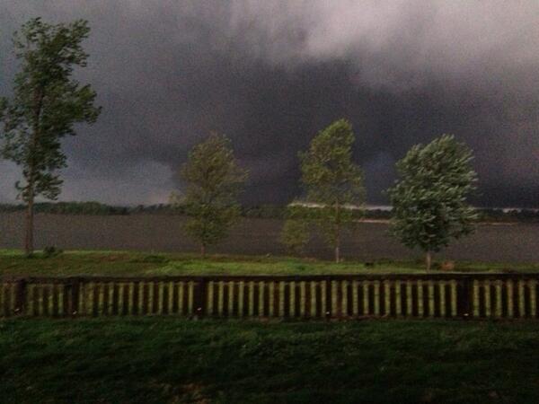
Around 7:30 - halfway betw Maumelle & Mayflower AR. MT Picture of a tornado that hit a plantation
originally posted by: ColorLightShape
originally posted by: TXTriker
originally posted by: TechniXcality
a reply to: TXTriker
waiting for 00utc models will update
nam is only 12 hrs out here is the latest images 12 hrs
www.instantweathermaps.com...
So that is where they are supposed to be in the next 12 hours? Sorry, not really intelligent about the maps but definitely willing to learn.
Every map I look at is slightly different... I am having a hard time figuring out which is LIVE vs. which is a forecast over the next couple of days. I appreciate this thread!
Me too! I truly appreciate that those that are able can keep us updated. As stated previously, I grew up in SW OK so am familiar with the storms and think they are one of the most amazing (even though deadly) manifestations of mother nature. We used to sit outside on the cellar steps and watch as the played across the skies.
edit on 4/27/2014 by TXTriker because: (no reason given)
a reply to: Havox
I live in Maumelle, this thing came real real close to us, there has been a couple fatalities so far, at least that is what has been reported. I have some friends in Mayflower, but I havent been able to get ahold of them yet, they are calling it as being half to 3/4 of a mile wide, the news just announced as I am typing this that Faulkner county has been declared a disaster zone. There is also a number of highways shutdown and there is a huge gas leak as well.
I live in Maumelle, this thing came real real close to us, there has been a couple fatalities so far, at least that is what has been reported. I have some friends in Mayflower, but I havent been able to get ahold of them yet, they are calling it as being half to 3/4 of a mile wide, the news just announced as I am typing this that Faulkner county has been declared a disaster zone. There is also a number of highways shutdown and there is a huge gas leak as well.
sorry correction the 15utc model wasn't ready here is the 12utc model they represent 3hr intervals. so they never represent current observation but
instead the last 3 hrs this stipulation becomes important when tracking winter storms because it can mean the difference between snow and rain..
mag.ncep.noaa.gov... am&area=namer&cycle=00¶m=500_vort_ht%7C1000_500_thick%7C700_rh_ht%7C850_temp_ht&fhr=012&group=Model+Guidance&preselected_formatted_cycle_date=2014 0428+00+UTC&ps=area&scrollx=0&scrolly=0
mag.ncep.noaa.gov... am&area=namer&cycle=00¶m=500_vort_ht%7C1000_500_thick%7C700_rh_ht%7C850_temp_ht&fhr=012&group=Model+Guidance&preselected_formatted_cycle_date=2014 0428+00+UTC&ps=area&scrollx=0&scrolly=0
yes absolutely this storm system represents a severe threat all the way to the east coast
mag.ncep.noaa.gov... am&area=namer&cycle=00¶m=500_vort_ht%7C1000_500_thick%7C700_rh_ht%7C850_temp_ht&fhr=024&group=Model+Guidance&preselected_formatted_cycle_date=2014 0428+00+UTC&ps=area&scrollx=0&scrolly=0
mag.ncep.noaa.gov... am&area=namer&cycle=00¶m=500_vort_ht%7C1000_500_thick%7C700_rh_ht%7C850_temp_ht&fhr=024&group=Model+Guidance&preselected_formatted_cycle_date=2014 0428+00+UTC&ps=area&scrollx=0&scrolly=0
edit on 27-4-2014 by TechniXcality because: (no reason given)
TXTriker: What an amazing experience to have growing up!
edit on 27-4-2014 by ColorLightShape because: (no reason
given)
edit on 27-4-2014 by ColorLightShape because: (no reason given)
edit on 27-4-2014 by ColorLightShape because:
edit
a reply to: MrLimpet
Everything I've read says tornado season will likely be pushed back a bit and milder like last year.
3 and 4 years ago were intense seasons. Last year was mild in comparison.
The reason this year has been slow is because its still cold and the lakes up north are frozen creating a flow of cool air which is the opposite of what thunderstorms need.
Not saying there wont be aome outbreaks or big tornadoes later but right now its kinda mild.
At 9:05pm CDT a tornado was reported near Macks, AR (tornado symbol) - just W of Newport. Moving NE 40 mph.
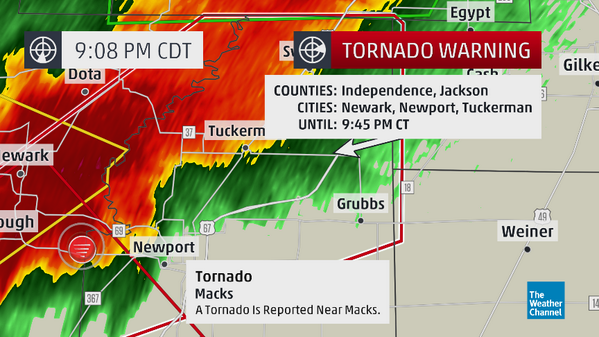
8:54 p.m. CDT Sunday: The National Weather Service is reporting a tornado emergency for Thida and Oil Trough, Ark.
8:47 p.m. CDT Sunday: Law enforcement reporting a tornado in Denmark, Ark.
8:41 p.m. CDT Sunday: Around 17,000 power outages with 11,000 in Pulaski County, Ark reports Entergy Arkansas
8:33 p.m. CDT Sunday: According to KATV in Little Rock, one person has been confirmed dead along Highway 365 in Mayflower.
new topics
-
Nasa astronaut distress message broadcast in error, Maybe!
General Conspiracies: 4 minutes ago -
Christian knights continue delivering babies in Bethlehem as conflict devastates Holy Land
Mainstream News: 7 minutes ago -
What do you guys think about developmentally delayed people having babies?
Rant: 14 minutes ago -
Why does humanity accept bad leaders?
Social Issues and Civil Unrest: 4 hours ago -
BLACK AMERICA is Moving towards TRUMP After Being Used-Abused-Insulted by President BIDEN.
2024 Elections: 10 hours ago -
Sheriff: Up to 10 people shot at Rochester Hills splash pad; gunman 'contained'
Breaking Alternative News: 11 hours ago
top topics
-
Biden Has Not Connected One Person with High-Speed Internet
US Political Madness: 14 hours ago, 13 flags -
Sheriff: Up to 10 people shot at Rochester Hills splash pad; gunman 'contained'
Breaking Alternative News: 11 hours ago, 11 flags -
Madness in Manchester! At todays protest
Social Issues and Civil Unrest: 17 hours ago, 8 flags -
BLACK AMERICA is Moving towards TRUMP After Being Used-Abused-Insulted by President BIDEN.
2024 Elections: 10 hours ago, 5 flags -
Would you sacrifice your heart?
General Chit Chat: 12 hours ago, 5 flags -
Understanding the Biblical story of Abraham's intended sacrifice of Isaac...
Conspiracies in Religions: 14 hours ago, 4 flags -
Why does humanity accept bad leaders?
Social Issues and Civil Unrest: 4 hours ago, 2 flags -
What do you guys think about developmentally delayed people having babies?
Rant: 14 minutes ago, 0 flags -
Christian knights continue delivering babies in Bethlehem as conflict devastates Holy Land
Mainstream News: 7 minutes ago, 0 flags -
Nasa astronaut distress message broadcast in error, Maybe!
General Conspiracies: 4 minutes ago, 0 flags
active topics
-
Italy hit by Water Bomb and Biblical hail
Fragile Earth • 32 • : Hakaiju -
The far right’s election gains rattle EU’s traditional powers
Mainstream News • 72 • : Ohanka -
Nasa astronaut distress message broadcast in error, Maybe!
General Conspiracies • 0 • : Scratchpost -
Christian knights continue delivering babies in Bethlehem as conflict devastates Holy Land
Mainstream News • 0 • : ADVISOR -
For 75 Years Cultural Marxism Worked to Destroy American Patriotism
New World Order • 44 • : Solvedit -
What do you guys think about developmentally delayed people having babies?
Rant • 0 • : Shoshanna -
Post A Funny (T&C Friendly) Pic Part IV: The LOL awakens!
General Chit Chat • 7252 • : PinkFreud -
Biden Has Not Connected One Person with High-Speed Internet
US Political Madness • 44 • : rdambroso -
Why does humanity accept bad leaders?
Social Issues and Civil Unrest • 19 • : rdambroso -
Understanding the Biblical story of Abraham's intended sacrifice of Isaac...
Conspiracies in Religions • 7 • : DISRAELI2