It looks like you're using an Ad Blocker.
Please white-list or disable AboveTopSecret.com in your ad-blocking tool.
Thank you.
Some features of ATS will be disabled while you continue to use an ad-blocker.
share:
Engineers have started emergency procedures to stabilize a Washington dam after they found a 65-foot crack in the structure.
The Wanapum Dam, a hydroelectric project located on the Columbia River in Grant County, Wash., is still running after divers discovered a 65-foot crack that is 2-inches wide.
The problem was first identified after an engineer noticed a “bowing” in the roadway above the dam and later discovered that a concrete spillway was raised above the water by 2.5 inches, according to Grant County Public Utility District spokesman Thomas Stredwick.
news.yahoo.com...
A lot of comments about our failing infrastructure on that post at Yahoo. And I have to agree. We got too many problems here at home that need fixing to be sending all our tax dollars overseas in either aid or military fiascoes. And people are quick to point out that the article says Vantage, six miles upstream, would be the town most affected by a dam failure there. What about all the towns and subsequent dams downstream?
Anyways, situation bears watching, as no one needs a 100 foot wall of water bearing down on them.
Update:
BEVERLY — Grant County PUD has alerted emergency officials, state agencies, other dam operators and downstream property owners that a potential failure situation is developing at Wanapum Dam.
PUD spokesman Tom Stredwick said that the “Emergency Action Plan B” was declared at approximately 3 p.m. Friday. That level of alert means that a potential failure situation is developing, he said.
The alert is akin to a “Level 1” wildfire evacuation notice, he said. Under a Level 1, residents who live within the vicinity of a fire are advised to be alert to danger and follow emergency and news broadcasts, but to stay in their homes.
“Catastrophic failure is very unlikely,” PUD assistant general manager Chuck Berry said late Friday. “We’re generating now. We’re not anticipating a huge amount of water coming. In a worst-case scenario and that piece of the spillway would fail, the flows that would move into the river below would not exceed the regular flow of the Columbia River. There is plenty of room to handle it.”
www.wenatcheeworld.com...
Uh huh, and authorities told the people not to evacuate the twin towers. And what the hell, the EPA told the 9/11 first responders that the air was safe. Yep. Righto.
edit on Sat Mar 1st 2014 by TrueAmerican because: (no reason given)
TrueAmerican
Engineers have started emergency procedures to stabilize a Washington dam after they found a 65-foot crack in the structure.
The Wanapum Dam, a hydroelectric project located on the Columbia River in Grant County, Wash., is still running after divers discovered a 65-foot crack that is 2-inches wide.
The problem was first identified after an engineer noticed a “bowing” in the roadway above the dam and later discovered that a concrete spillway was raised above the water by 2.5 inches, according to Grant County Public Utility District spokesman Thomas Stredwick.
news.yahoo.com...
A lot of comments about our failing infrastructure on that post at Yahoo. And I have to agree. We got too many problems here at home that need fixing to be sending all our tax dollars overseas in either aid or military fiascoes. And people are quick to point out that the article says Vantage, six miles upstream, would be the town most affected by a dam failure there. What about all the towns and subsequent dams downstream?
Anyways, situation bears watching, as no one needs a 100 foot wall of water bearing down on them.
So, just to be clear, this a crack 65' long and 2" wide. Seems pretty significant.
Wasn't the stimulus supposed to take care of this?
Where did all that money go again?
Where did all that money go again?
ketsuko
Wasn't the stimulus supposed to take care of this?
Where did all that money go again?
Where did all the money go?.....well....into a different "crack" entirely. One found on the backsides of the global elite.
Thanks for sharing TA.
We do have a big infrastructure problem in this country and it's sad. Very sad indeed.
We do have a big infrastructure problem in this country and it's sad. Very sad indeed.
reply to post by TrueAmerican
That seems like a pretty damn significant crack forming there. Do they have any idea what caused it? Maybe an earthquake in the area or was this just a case of piss poor American engineering? My guess is that, because of cuts, they cut back on their maintenance budget and haven't been properly maintaining the place.
If that place is run anything like where I work, they probably wait for an emergency to develop before they allocate any funds to fix the big things.
reply to post by TrueAmerican
This is not too far from me though I'm upriver of the dam. The gradient below that dam is fairly steep from what I remember. Not a lot of homes along it either but I may be wrong on that. There does seem to be a significant amount of water above the dam though. Hope they can patch this up.
ETA - The west side of the river is quite steep with high hills, the east side however is pretty flat and where the houses are from what I recall.

edit on 151pm3333pm82014 by Bassago because: (no reason given)
Bassago
reply to post by TrueAmerican
This is not too far from me though I'm upriver of the dam. The gradient below that dam is fairly steep from what I remember. Not a lot of homes along it either but I may be wrong on that. There does seem to be a significant amount of water above the dam though. Hope they can patch this up.
ETA - The west side of the river is quite steep with high hills, the east side however is pretty flat and where the houses are from what I recall.
edit on 151pm3333pm82014 by Bassago because: (no reason given)
the only way to fix a crack going all the way through the dam is to use a water cured epoxy on the water side, and an injectable medium speed cured epoxy on the inside. You will need divers to put the plumbers type of epoxy on the water side, and then on the opposite side put 2 inch injection ports every 12 inches and seal the crack between the ports. then start injecting medium curing speed epoxy starting at the lowest port filling the crack from the bottom up. But if I am not mistaken these dams are not solid cement there is a cause way between one side and the other and even different floors in some. though you could still use the same procedure if it is solid or not.
the thing to think of in any case is what caused the crack. Is it shifting because of the water weight or is it separation of the two side of the dam.
edit on 1-3-2014 by ChesterJohn because: (no reason given)
sheepslayer247
Thanks for sharing TA.
We do have a big infrastructure problem in this country and it's sad. Very sad indeed.
It is sad because it isn't that we don't have the money for it but that the people who were entrusted to spend that money wisely made it disappear into their own pockets instead.
Do you know what happened in NOLA? Each of the levees has its own political body appointed to look after it and make sure it's kept up. They all talked about how there was no money for upgrading those levees after Katrina? That's crap. The money was there, but it all found its way into various bureaucrat bank accounts instead of going to its actual intended purpose.
You'll find that kind of corruption all over the place. After all, what are the odds that the dam or bridge you're supposed to be overseeing the upgrade of is actually going to crumble at any point when it can be traced back to your mismanagement of funds and lack of initiative in getting anything done?
Besides, if they kept all our infrastructure looking shiny and new, what would they point to when they felt the need to buy a new vacation home, er, raise taxes?
reply to post by TrueAmerican
Flag and star
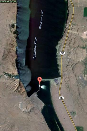
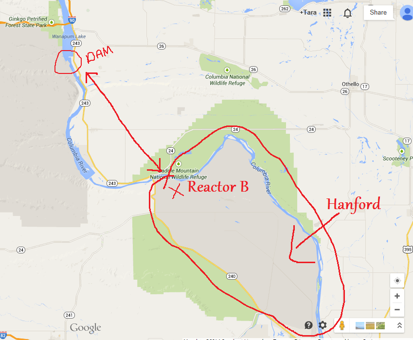
Wow. This is scary stuff. Wanna know why????
Take a look at this:

I don't know about anyone else.....but that is WAY too close for comfort!!!
I have a lot of family in the area, I will be sure to share this with them
As to what caused this, I'm thinking there may be some seismic relation. LOTS of swarms there in the past few years, some in the 3-4 mag range, very close to the dam.
Flag and star
Wow. This is scary stuff. Wanna know why????
Take a look at this:

I don't know about anyone else.....but that is WAY too close for comfort!!!
I have a lot of family in the area, I will be sure to share this with them
As to what caused this, I'm thinking there may be some seismic relation. LOTS of swarms there in the past few years, some in the 3-4 mag range, very close to the dam.
edit on 1-3-2014 by westcoast because: (no reason given)

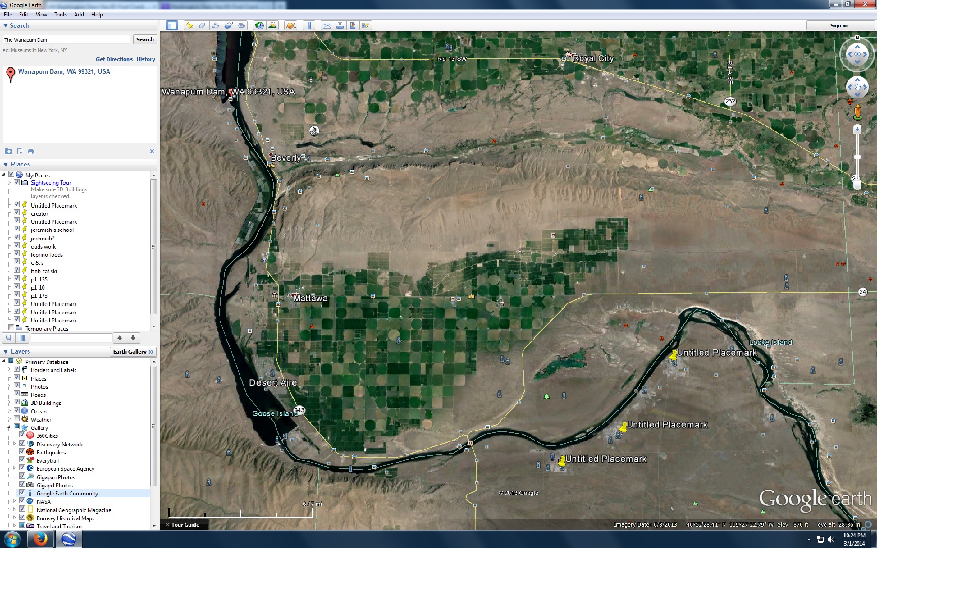
Would be a great way to wash all your nuke waste troubles away; along with responsibility.
Pointer are old nuke sites....and more
So is it a stretch to think, a town with super high cancer rates discovered, a crack discovered in a dam upstream of several nuke waste sites near by, and an announcement that we need to spend on infrastructure; for a told you so; all go together ???
Legally if it's every where then how can anyone blame anyone for anything?
Act of God or Human greed?
Could those sites have been placed below the dams and by the river just so you could flush them away if there was trouble?
Everything is fair in war?
edit on 1-3-2014 by donlashway because: (no reason given)
edit on 1-3-2014 by donlashway because:
(no reason given)
reply to post by westcoast
Jesus. Well THAT certainly adds a whole new dimension to this, now doesn't it. Excellent work, west! Let's just hope if the first dam fails, the subsequent ones will hold the overflow. Cause, ahh, Fukushima didn't exactly hold out to well against a 25 foot wave. This situation might be way worse than anyone thought. Either that or they know this, but are downplaying the situation, intentionally to avoid public panic. Wouldn't be the first time, won't be the last.
Jesus. Well THAT certainly adds a whole new dimension to this, now doesn't it. Excellent work, west! Let's just hope if the first dam fails, the subsequent ones will hold the overflow. Cause, ahh, Fukushima didn't exactly hold out to well against a 25 foot wave. This situation might be way worse than anyone thought. Either that or they know this, but are downplaying the situation, intentionally to avoid public panic. Wouldn't be the first time, won't be the last.
Bassago
reply to post by TrueAmerican
edit on 151pm3333pm82014 by Bassago because: (no reason given)
This doesn't look like you A-typical dam. Usually when we think of a dam we thing the HOVER dam in Nevada arched and large.
IMHO this looks more like a flood control dam and further down river it looks as if there is another small flood control dam. If it is more of a flood control station it was not meant to hold back water for long periods of time. It is mean to hold it back long enough to allow the flood prone lands below it some relief during rainy seasons and then release it during the dyer seasons.
It could be this dam was not meant to hold back so much water and that is why it is cracking.
ketsuko
Wasn't the stimulus supposed to take care of this?
Where did all that money go again?
I think that crack counted as a "shovel ready Job" if any.
Where did all that unspent stimulus go anyway?
reply to post by TrueAmerican
wiki
Already updated for leek, crack....
Little more info...
wiki
Wanapum Dam is a hydroelectric project located on the Columbia River downstream (south) from Vantage, Washington where Interstate 90 crosses the Columbia from Grant County into Kittitas County. It is owned by the Grant County Public Utility District. Its reservoir is named Lake Wanapum. The dam, and its lake, are named after the Wanapum Indians. The dam has a rated capacity of 1,038 megawatts and annually generates over 4 million megawatt-hours.[2] History The Wanapum dam was originally licensed in 1955 for a period of 50 years. Construction was initiated in 1959 with initial beneficial operation in 1963. The initial license expired in 2005, after which the Grant County PUD operated the dam on yearly license extensions while negotiations for license extension proceeded. The Federal Energy Regulatory Commission approved a license extension of 44 years for both the Wanapum dam and the downstream Priest Rapids dam on April 17, 2008. The license extension was conditioned upon programs to: modernize the power generation capability of the dam, monitor water quality, improve wildlife habitat, protect nearly 700 Wanapum Tribe archaeological sites in the vicinity, and enhance recreation with new campsites, picnic areas and trails.[3] Crack On March 1, 2014, USA Today reported that "A 65-foot-long crack in a Columbia River dam in central Washington has prompted officials to begin lowering the water level by 20 feet so inspectors can get a better idea of how serious the damage is." [4]
Already updated for leek, crack....
Little more info...
donlashway
reply to post by TrueAmerican
wiki
Wanapum Dam is a hydroelectric project located on the Columbia River downstream (south) from Vantage, Washington where Interstate 90 crosses the Columbia from Grant County into Kittitas County. It is owned by the Grant County Public Utility District. Its reservoir is named Lake Wanapum. The dam, and its lake, are named after the Wanapum Indians. The dam has a rated capacity of 1,038 megawatts and annually generates over 4 million megawatt-hours.[2] History The Wanapum dam was originally licensed in 1955 for a period of 50 years. Construction was initiated in 1959 with initial beneficial operation in 1963. The initial license expired in 2005, after which the Grant County PUD operated the dam on yearly license extensions while negotiations for license extension proceeded. The Federal Energy Regulatory Commission approved a license extension of 44 years for both the Wanapum dam and the downstream Priest Rapids dam on April 17, 2008. The license extension was conditioned upon programs to: modernize the power generation capability of the dam, monitor water quality, improve wildlife habitat, protect nearly 700 Wanapum Tribe archaeological sites in the vicinity, and enhance recreation with new campsites, picnic areas and trails.[3] Crack On March 1, 2014, USA Today reported that "A 65-foot-long crack in a Columbia River dam in central Washington has prompted officials to begin lowering the water level by 20 feet so inspectors can get a better idea of how serious the damage is." [4]
Already updated for leek, crack....
Little more info...
Looks and seems to me they need a new dam altogether.
reply to post by ChesterJohn
Looks to me like the normal method for propaganda.
Tuesday, they say it was discovered.
When did the talk of infrastructure repairs being needed start?
Looked around and found this, Study of bedrock errosion at Wanapum
That study was not cheap. Did they just dream it up or was there a reason ? Was it done before Tuesday?
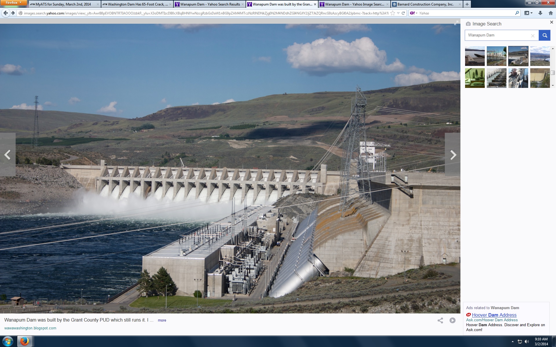
This pic from a blog 2011 blog

Notice a spillway not open ? This problem has been studied, worked on, planned. And now it is being used to demonstrait the need for repairs.
I don't think any one is arguing over the need for repairs.
If we get an understanding of how news and public opinion can be manipulated maybe we stand a chance, maybe ?
Looks to me like the normal method for propaganda.
Tuesday, they say it was discovered.
When did the talk of infrastructure repairs being needed start?
Looked around and found this, Study of bedrock errosion at Wanapum
That study was not cheap. Did they just dream it up or was there a reason ? Was it done before Tuesday?
This pic from a blog 2011 blog

Notice a spillway not open ? This problem has been studied, worked on, planned. And now it is being used to demonstrait the need for repairs.
I don't think any one is arguing over the need for repairs.
If we get an understanding of how news and public opinion can be manipulated maybe we stand a chance, maybe ?
edit on 2-3-2014 by donlashway
because: (no reason given)
edit on 2-3-2014 by donlashway because: (no reason given)
edit on 2-3-2014 by donlashway
because: (no reason given)
Well give me six PADI Cert. divers, Six regular experienced workers, and about $2.3 Million. I can repair it just as good as new.
But if the erosion problem is not addressed it will appear again and not necessarily in the same spot.
Are they taking repair bids?
But if the erosion problem is not addressed it will appear again and not necessarily in the same spot.
Are they taking repair bids?
ChesterJohn
Bassago
reply to post by TrueAmerican
edit on 151pm3333pm82014 by Bassago because: (no reason given)
This doesn't look like you A-typical dam. Usually when we think of a dam we thing the HOVER dam in Nevada arched and large.
IMHO this looks more like a flood control dam and further down river it looks as if there is another small flood control dam. If it is more of a flood control station it was not meant to hold back water for long periods of time. It is mean to hold it back long enough to allow the flood prone lands below it some relief during rainy seasons and then release it during the dyer seasons.
It could be this dam was not meant to hold back so much water and that is why it is cracking.
My Dad just reminded me that he took me there once as a child. I had wondered if that was the dam I remembered, but I thought that maybe it was hoover dam because I just remember how BIG it was, and it freaked me out walking out on top of it.
No...this is not just a small, flood control dam. It was built for hydroelectric power, so there is a pretty decent flow moving through it. I honestly don't know what kind of risks there would be for anyone (or Hanford) downstream, but all you have to do is look at the reservoir behind it, the amount of water that flows through it every day and it seems to me that at least some concern is warranted.
hopefully it is repaired and any sort of collapse is avoided.
new topics
-
Those Drones over NJ and elsewhere
Aliens and UFOs: 4 hours ago -
South Korean coup was an attempt to start WW3
World War Three: 4 hours ago -
Archer aviation and the NJ drones
Aircraft Projects: 4 hours ago
top topics
-
Only two Navy destroyers currently operational as fleet size hits record low
Military Projects: 15 hours ago, 12 flags -
Those Drones over NJ and elsewhere
Aliens and UFOs: 4 hours ago, 6 flags -
South Korean coup was an attempt to start WW3
World War Three: 4 hours ago, 5 flags -
Archer aviation and the NJ drones
Aircraft Projects: 4 hours ago, 4 flags
active topics
-
One out of every 20 Canadians Dies by Euthanasia
Medical Issues & Conspiracies • 26 • : Xtrozero -
Something better
Dissecting Disinformation • 27 • : chr0naut -
Could rampant land speculation have caused the Civil War?
History • 32 • : Solvedit -
They Know
Aliens and UFOs • 92 • : CarlLaFong -
Only two Navy destroyers currently operational as fleet size hits record low
Military Projects • 21 • : UpIsNowDown2 -
Stalker 2 - Review from a Veteran
Video Games • 3 • : gortex -
More Bad News for Labour and Rachel Reeves Stole Christmas from Working Families
Regional Politics • 6 • : covent -
-@TH3WH17ERABB17- -Q- ---TIME TO SHOW THE WORLD--- -Part- --44--
Dissecting Disinformation • 3700 • : CarlLaFong -
Those Drones over NJ and elsewhere
Aliens and UFOs • 7 • : xuenchen -
Post A Funny (T&C Friendly) Pic Part IV: The LOL awakens!
General Chit Chat • 7909 • : baddmove
