It looks like you're using an Ad Blocker.
Please white-list or disable AboveTopSecret.com in your ad-blocking tool.
Thank you.
Some features of ATS will be disabled while you continue to use an ad-blocker.

Huge Pinnacle that cast shadow on Mars?
page: 1share:
I stumbled upon this image www.msss.com... and detected a huge anomaly: A Pinnacle that cast shadow.
Rotate the image 180° and it is more clear. WTH is that thing?
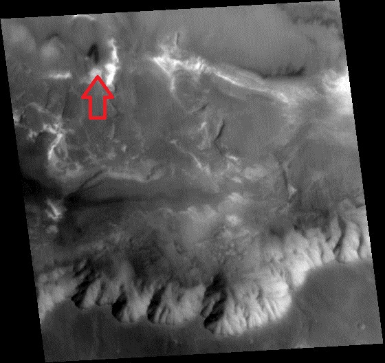
Rotate 180°
Detail
For what I can understand, that thing is really Big...
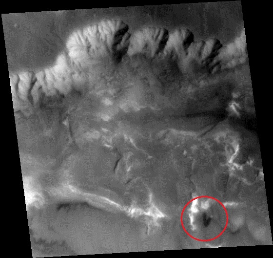
Rotate 180°
Detail
Derived values
Derived values
Longitude of image center: 70.61°W
Latitude of image center: 13.23°S
Scaled pixel width: 237.83 meters
Scaled image width: 115.19 km
Scaled image height: 119.21 km
Solar longitude (Ls): 165.66°
Local True Solar Time: 14.70 decimal hours
Emission angle: 3.47°
Incidence angle: 44.81°
Phase angle: 41.64°
North azimuth: 93.19°
Sun azimuth: 26.15°
Spacecraft altitude: 376.82 km
Slant distance: 377.45 km
Acquisition parameters
Image ID (picno): M03-00946
Image start time: 1999-07-05T20:32:32.90 SCET
Image width: 480 pixels
Image height: 480 pixels
Line integration time: 80.4800 millisec
Pixel aspect ratio: 1.05
Crosstrack summing: 1
Downtrack summing: 1
Compression type: MOC-NONE
Gain mode: 4A (hexadecimal)
Offset mode: 7 (decimal)
For what I can understand, that thing is really Big...
edit on 13-11-2012 by Arken because: (no reason given)
reply to post by Arken
Arken
I'm feeling a little Space Odyssey now.
Obelisk?
Mars, the potential planet we previously habited. Or at least someone/thing did.
Arken
I'm feeling a little Space Odyssey now.
Obelisk?
Mars, the potential planet we previously habited. Or at least someone/thing did.
Is there any co-ordinates with this so we can look it up on Google Mars?
Wow, reminds me of a Monolith or Obelisk.
Ofcorse could be a natural formation, we do have some weird rock formations on our planet which stick up like spikes and would cause long shadows.
Is there anyway to gauge the scale of the object?
Namaste.
Ofcorse could be a natural formation, we do have some weird rock formations on our planet which stick up like spikes and would cause long shadows.
Is there anyway to gauge the scale of the object?
Namaste.
edit on 13/11/12 by WiseThinker because: (no reason given)
Strange because the shadow on the mountains seems to cast differently then the oblisk ?
watching it more closely, than maybe I'm wrong.. and did you find something big!
watching it more closely, than maybe I'm wrong.. and did you find something big!
edit on 13-11-2012 by 0bserver1 because: (no reason
given)
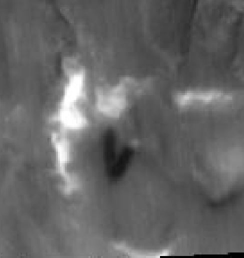
In my opinion it looks like two wide ridges that are not too tall. Look how the sun falls... it's from the side. It fits perfectly with those two be
a ridge and then to the right a lower level ridge.
reply to post by WiseThinker
At least 10km high.
You'd have thought a natural rock formation surely couldn't last at that height.
Or, I could be wrong. It's not 10km high.
At least 10km high.
You'd have thought a natural rock formation surely couldn't last at that height.
Or, I could be wrong. It's not 10km high.
edit on 13-11-2012 by LightAssassin because: (no reason given)
reply to post by WiseThinker
Added all the data in the Opening Post.
For what I can understand, that thing is really big....
Is there anyway to gauge the scale of the object?
Added all the data in the Opening Post.
For what I can understand, that thing is really big....

reply to post by MysticEngineer
Well, someone (Phage and ArmAp) told me, dozens of times, that Google Earth/Moon/Mars IS NOT a reliable source...
Who is right?
Well, someone (Phage and ArmAp) told me, dozens of times, that Google Earth/Moon/Mars IS NOT a reliable source...
Who is right?
edit on 13-11-2012 by Arken because: (no reason given)
Originally posted by MysticEngineer
That's a illusion caused by the low resolution of the picture. The tower is indeed just white and black sand.
See it here.
your 2nd image pretty well explains the situation...
the source for the visual illusion is just dark ejecta in a 'V' pattern..from what appears is a crater or a very unlikely caldera of an ancient volcano
thanks for the image
edit on 13-11-2012 by St Udio because: (no reason given)
Originally posted by St Udio
Originally posted by MysticEngineer
That's a illusion caused by the low resolution of the picture. The tower is indeed just white and black sand.
See it here.
your 2nd image pretty well explains the situation...
the source for the visual illusion is just dark ejecta in a 'V' pattern..from what appears is a crater or a very unlikely caldera of an ancient volcano
thanks for the imageedit on 13-11-2012 by St Udio because: (no reason given)
Actually those coordinates are inside Valles Marineris.. one of largest canyons of solar system and obviously mars. If you open the 1st high resolution picture available on wikipedia, you can see the same area with the "V" pattern around (4902px, 1980px) albeit really small.
en.wikipedia.org...
edit on 13-11-2012 by MysticEngineer
because: (no reason given)
edit on 13-11-2012 by MysticEngineer because: (no reason given)
Originally posted by Arken
reply to post by MysticEngineer
Well, someone (Phage and ArmAp) told me, dozens of times, that Google Earth/Moon/Mars IS NOT a reliable source...
Who is right?edit on 13-11-2012 by Arken because: (no reason given)
Every tool available (be it Google Earth, HubbleST, HiRISE, you name it) has its engineering limitations and tolerances you have to be aware of to be able to interpret the data correctly.
reply to post by MysticEngineer
How do you get that incredibly hi-res images in Google Earth? All I get is the low-res colour version.
P.S. I found this site for all the planetary images, I think it's very reliable:
pds-imaging.jpl.nasa.gov...
How do you get that incredibly hi-res images in Google Earth? All I get is the low-res colour version.
P.S. I found this site for all the planetary images, I think it's very reliable:
pds-imaging.jpl.nasa.gov...
edit on 13-11-2012 by wildespace because: (no reason given)
Originally posted by Arken
reply to post by MysticEngineer
Well, someone (Phage and ArmAp) told me, dozens of times, that Google Earth/Moon/Mars IS NOT a reliable source...
Who is right?edit on 13-11-2012 by Arken because: (no reason given)
Arken YOU know very well by NOW any hires image on Google Earth,Moon or Mars is usually from another source like the LRO HiRise ETC.
Did you not read the txt at the bottom of the images you were shown?
.
edit on 13-11-2012 by wmd_2008 because: (no reason given)
reply to post by wildespace
In Layers, you must tick Global Maps->CTX Mosaic. Also you can see the data strips if you tick Spacecraft Imagery->CTX Image Browser, but the external data sources from nasa seemed to be offline, reason why i didnt provided a reference link. There are other layers you can use though.
Now after enabling this if you want to see something nice, search for Orcus Patera. Zoom in to the maximum resolution with the CTX enabled and see the edges of that crater. You will find many "water" like features going down the edges.
edit on 13-11-2012 by MysticEngineer because: (no reason
given)
Originally posted by MysticEngineer
That's a illusion caused by the low resolution of the picture. The tower is indeed just white and black sand.
See it here.
Where do you get that incredibly hi-res images in Google Earth?
What "kind" of Google Earth do you have?
A NEW "kind" of still not public Google Earth and not yet downloadable?
All we get is the low-res yellowish colour version.
Why and how you have that version?
new topics
-
President BIDEN's FBI Raided Donald Trump's Florida Home for OBAMA-NORTH KOREA Documents.
Political Conspiracies: 2 hours ago -
Maestro Benedetto
Literature: 4 hours ago -
Is AI Better Than the Hollywood Elite?
Movies: 4 hours ago -
Las Vegas UFO Spotting Teen Traumatized by Demon Creature in Backyard
Aliens and UFOs: 7 hours ago -
2024 Pigeon Forge Rod Run - On the Strip (Video made for you)
Automotive Discussion: 8 hours ago -
Gaza Terrorists Attack US Humanitarian Pier During Construction
Middle East Issues: 8 hours ago -
The functionality of boldening and italics is clunky and no post char limit warning?
ATS Freshman's Forum: 10 hours ago -
Meadows, Giuliani Among 11 Indicted in Arizona in Latest 2020 Election Subversion Case
Mainstream News: 10 hours ago -
Massachusetts Drag Queen Leads Young Kids in Free Palestine Chant
Social Issues and Civil Unrest: 10 hours ago
top topics
-
President BIDEN's FBI Raided Donald Trump's Florida Home for OBAMA-NORTH KOREA Documents.
Political Conspiracies: 2 hours ago, 23 flags -
Krystalnacht on today's most elite Universities?
Social Issues and Civil Unrest: 13 hours ago, 9 flags -
University of Texas Instantly Shuts Down Anti Israel Protests
Education and Media: 16 hours ago, 8 flags -
Weinstein's conviction overturned
Mainstream News: 12 hours ago, 8 flags -
Supreme Court Oral Arguments 4.25.2024 - Are PRESIDENTS IMMUNE From Later Being Prosecuted.
Above Politics: 13 hours ago, 8 flags -
Massachusetts Drag Queen Leads Young Kids in Free Palestine Chant
Social Issues and Civil Unrest: 10 hours ago, 7 flags -
Gaza Terrorists Attack US Humanitarian Pier During Construction
Middle East Issues: 8 hours ago, 7 flags -
Las Vegas UFO Spotting Teen Traumatized by Demon Creature in Backyard
Aliens and UFOs: 7 hours ago, 6 flags -
Meadows, Giuliani Among 11 Indicted in Arizona in Latest 2020 Election Subversion Case
Mainstream News: 10 hours ago, 5 flags -
2024 Pigeon Forge Rod Run - On the Strip (Video made for you)
Automotive Discussion: 8 hours ago, 4 flags
active topics
-
President BIDEN's FBI Raided Donald Trump's Florida Home for OBAMA-NORTH KOREA Documents.
Political Conspiracies • 8 • : WeMustCare -
-@TH3WH17ERABB17- -Q- ---TIME TO SHOW THE WORLD--- -Part- --44--
Dissecting Disinformation • 685 • : RelSciHistItSufi -
SETI chief says US has no evidence for alien technology. 'And we never have'
Aliens and UFOs • 74 • : Justoneman -
Starburst galaxy M82 - Webb Vs Hubble
Space Exploration • 6 • : Arbitrageur -
University of Texas Instantly Shuts Down Anti Israel Protests
Education and Media • 264 • : stelth2 -
Chris Christie Wishes Death Upon Trump and Ramaswamy
Politicians & People • 22 • : stelth2 -
VirginOfGrand says hello
Introductions • 9 • : TheMichiganSwampBuck -
Las Vegas UFO Spotting Teen Traumatized by Demon Creature in Backyard
Aliens and UFOs • 10 • : pianopraze -
Supreme Court Oral Arguments 4.25.2024 - Are PRESIDENTS IMMUNE From Later Being Prosecuted.
Above Politics • 84 • : Daughter2v2 -
Is AI Better Than the Hollywood Elite?
Movies • 12 • : rickymouse