It looks like you're using an Ad Blocker.
Please white-list or disable AboveTopSecret.com in your ad-blocking tool.
Thank you.
Some features of ATS will be disabled while you continue to use an ad-blocker.

BREAKING: Proof NASA/JPL Copy & Pasted Images at Gale Crater Curiosity Landing Site on Mars!
page: 10share:
reply to post by Unity_99
That's why Sat-Phones, GPS devices, weather satellites, etc, don't work. PERIOD.
NASA is all about Falsifying the data. PERIOD.
That's why Sat-Phones, GPS devices, weather satellites, etc, don't work. PERIOD.
Perfect examples. marsanomalyresearch.com is by far one of my favorites. I dont just look at the pictures, but have read his photo analysis, and the
many proofs of tampering that anyone with any expertise can see.
Here is the tampering job. They masked the water and oh my dear, but do I notice trees. Lots of them.
And why is curiosity there? Getting real data for us? Why is it in what looks like nevada after satanists disposed of bodies so fingers are lying around? Or some site of a disaster if it really is mars, where petrified fingers are lying around.
THEY OWE HUMANITY AND I'M KEEPING THEIR BILL.
www.marsanomalyresearch.com...
Read the articles.
My friend, half native, was saying at one point, what trees on mars, and I only had to show her the aerial photos, no NASA explanation could take the huge grin that lit up her face, because she trusts her eyes, and knew.
Here is the tampering job. They masked the water and oh my dear, but do I notice trees. Lots of them.
And why is curiosity there? Getting real data for us? Why is it in what looks like nevada after satanists disposed of bodies so fingers are lying around? Or some site of a disaster if it really is mars, where petrified fingers are lying around.
THEY OWE HUMANITY AND I'M KEEPING THEIR BILL.
www.marsanomalyresearch.com...
Remember that the Mars surface is officially suppose to be completely dry and devoid of life. Further, the atmosphere is suppose to be 95.35% carbon dioxide (CO2) with only a very tiny .03% of water vapor and super hard frozen to the tune of as much as –220º Fahrenheit or –140º Celsius. In other words it would be a race as to whether an unprotected Earth human out in the open there would be speedily killed by too much poisonous CO2 gas by many times over or quickly frozen to death.
Note that, even though all of the following evidence is in the official science data and available there for verification, you have never heard a peep out of NASA or JPL as to its existence. So this amounts to the hidden Mars that it appears someone in control does not wish you and I to know about or at least also ignore. Also note that I have added a slight bit of false color to these online images to increase clarity and the viewing comfort level. In any case, the high drama visual evidence is as follows.
Read the articles.
My friend, half native, was saying at one point, what trees on mars, and I only had to show her the aerial photos, no NASA explanation could take the huge grin that lit up her face, because she trusts her eyes, and knew.
edit on 24-9-2012 by Unity_99 because: (no reason given)
I agree with the maker of that video, they just copied and pasted, and slightly altered pics and moved them around, so he was quite right when he
said: you might as well take the image and throw it in the trash, for you don't know what you're looking at here.
Just one SNOW JOB AFTER ANOTHER. THEY ARE SUCH PSYCHOS! THEY ARE NOT OFF ANY HOOKS, BUT ANSWER FOR THIS.
Just one SNOW JOB AFTER ANOTHER. THEY ARE SUCH PSYCHOS! THEY ARE NOT OFF ANY HOOKS, BUT ANSWER FOR THIS.
Course I could have thought of a thousand better places to show up.
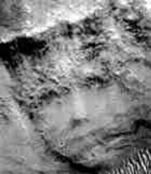
This time they call him/her the princess. But I've read somewhere that the sumar texts talk about a hero/astonaut, put on a huge mountain. and this could be that. Very human face, eh?
So why is curiosity sitting in a pile of blasted out rubble with fingers and weird things around it around it?
By the way, mars doesnt look like that video. its not an ugly rubble planet, it has forests, lakes, mountains and some disaster areas.
Personally I think they deserve prison sentences for fraud, and extortion.
edit on 24-9-2012 by Unity_99 because: (no reason given)
reply to post by Unity_99
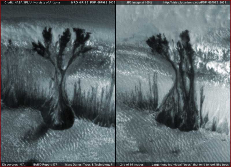
All of the so called trees on Mars happen in the Polar North and are carbon dioxide deposits.
Strange Mars Photo Includes Tantalizing 'Tree' Illusion
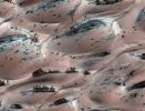

On the color pic you can actually see the deposits flowing down hill.
Click to enlarge.
The Martian "trees" are actually dark basaltic sand pushed to the surface of sand dunes by sun-heated solid carbon dioxide ice, or dry ice, sublimating directly into vapor, explained Candy Hansen, a member of NASA's Mars Reconnaissance Orbiter (MRO) team at the University of Arizona.
www.space.com...
"The princess" is an enlarged frame from an area taken by the MOC at NASA and if you look at the original strip and enlarge it about halfway down you can see "the princess" and it is obviously an optical illsion when viewed in its proper context.
All of the so called trees on Mars happen in the Polar North and are carbon dioxide deposits.
Strange Mars Photo Includes Tantalizing 'Tree' Illusion
On the color pic you can actually see the deposits flowing down hill.
Click to enlarge.
The Martian "trees" are actually dark basaltic sand pushed to the surface of sand dunes by sun-heated solid carbon dioxide ice, or dry ice, sublimating directly into vapor, explained Candy Hansen, a member of NASA's Mars Reconnaissance Orbiter (MRO) team at the University of Arizona.
www.space.com...
"The princess" is an enlarged frame from an area taken by the MOC at NASA and if you look at the original strip and enlarge it about halfway down you can see "the princess" and it is obviously an optical illsion when viewed in its proper context.
Originally posted by DJW001
Claiming that the interactive landing site simulator are actual photos from Curiosity is a deliberate misrepresentation. That is what makes the title of this thread and the videos in the OP a hoax.
I don't remember hearing the guy on the video or the OP saying that.
Yes, some people that do not read what the thread's about said that, but not the OP.
I left off the MOC image of "The princess" in my last post and just found it in my archives. The image most people see is enlarged with the left and
right sides chopped off. In the MOC original you can see that the image is part of a cliff with scree,dust,and ravines meeting the face in a
continuation of soil debris.
Like the so called trees of Mars, People on web sites and the internet manipulate images too. Don't lay all of the blame on NASA.
On the MOC strip click it to enlarge and scroll down just past half way and you'll see the original face.
If you scroll down near the bottom you will see some dunes in a ravine that others claim are tunnels.
www.msss.com...
edit on 24-9-2012 by dcmb1409 because: (no reason given)
reply to post by Unity_99
But you know exactly what it is: it is an interactive map of the landing site made using CGI techniques. NASA makes this perfectly clear, it is the maker of the video who "forgets" to mention this.
Calm down.NASA are not the ones lying, at least in this case.
I agree with the maker of that video, they just copied and pasted, and slightly altered pics and moved them around, so he was quite right when he said: you might as well take the image and throw it in the trash, for you don't know what you're looking at here.
But you know exactly what it is: it is an interactive map of the landing site made using CGI techniques. NASA makes this perfectly clear, it is the maker of the video who "forgets" to mention this.
Just one SNOW JOB AFTER ANOTHER. THEY ARE SUCH PSYCHOS! THEY ARE NOT OFF ANY HOOKS, BUT ANSWER FOR THIS.
Calm down.NASA are not the ones lying, at least in this case.
Originally posted by DJW001
reply to post by Unity_99
But you know exactly what it is: it is an interactive map of the landing site made using CGI techniques. NASA makes this perfectly clear, it is the maker of the video who "forgets" to mention this.
Calm down.NASA are not the ones lying, at least in this case.
Where does NASA make this perfectly clear, i can't find this anywhere on the various Mars JPL websites.
I think it's fair and balanced in these situations to get a word from the other side, so i emailed NASA and attached an image with the two pairs of supposedly copied/pasted images highlighted.
I will post my email and their response in this thread when theyr espond.
QV.
reply to post by qvision
mars.jpl.nasa.gov...
Edit to add:
www.exploremars.org...
Where does NASA make this perfectly clear, i can't find this anywhere on the various Mars JPL websites.
Explore Mars:
Curiosity's Journey
Free Drive
Gale Crater
Learn About the Rover
This 3D interactive experience uses the Unity game engine. It enables delivery of a 3D terrain map of Gale Crater, where Curiosity will land, as well as a 3D model of the rover so you can follow along as if you
mars.jpl.nasa.gov...
Edit to add:
This oblique view of Gale, and Mount Sharp in the center, is derived from a combination of elevation and imaging data from three Mars orbiters. The image combines elevation data from the High Resolution Stereo Camera on the European Space Agency’s Mars Express orbiter, image data from the Context Camera on NASA’s Mars Reconnaissance Orbiter, and color information from Viking Orbiter imagery. There is no vertical exaggeration in the image. The view is looking toward the southeast. Mount Sharp rises about 5.5 kilometers (3.4 miles) above the floor of Gale Crater.
www.exploremars.org...
edit on 25-9-2012 by DJW001 because: (no reason given)
reply to post by dcmb1409
Oh you mean like this particular snow job?
www.telegraph.co.uk...
I'd be looking more at this:
www.popsci.com...
Now lets look at the firs link, again, but this time from a site I actually trust a lot more:
www.marsanomalyresearch.com...
There is a very long article about this widespread image, and too much there to quote. Need to read it.
Here is a good list of the tampering evidence:
www.marsanomalyresearch.com...
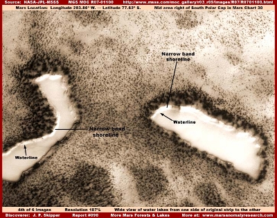
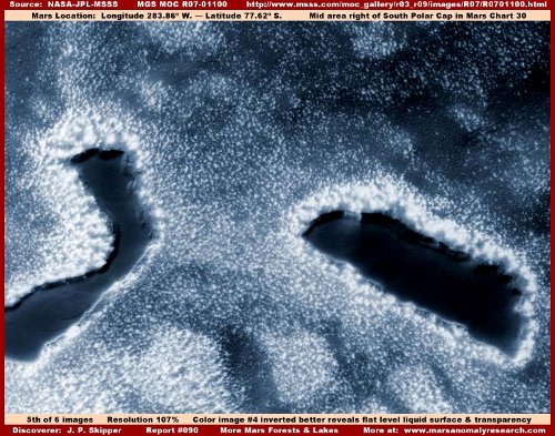
Water evidence:
www.marsanomalyresearch.com...
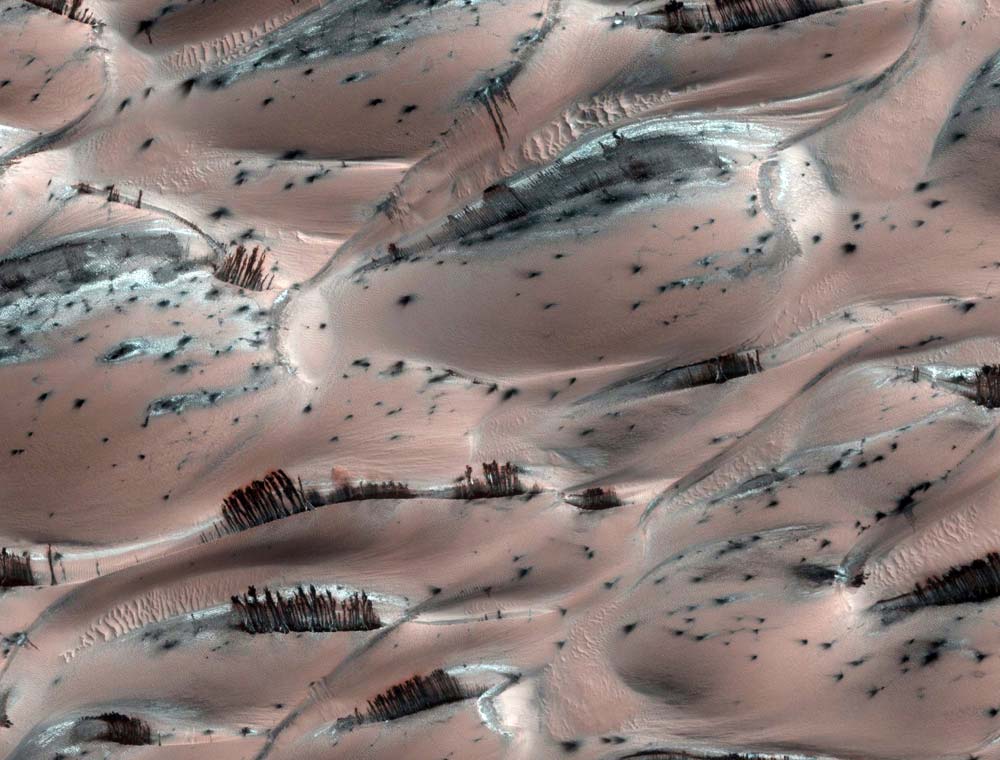
The trees are often around the lakes and all over.
Its like a planet that suffered a huge catastrophic event and is bouncing back.
Oh you mean like this particular snow job?
www.telegraph.co.uk...
I'd be looking more at this:
www.popsci.com...
Arthur C. Clarke The image is so striking that there is no need to say anything about it -- it's obviously vegetation to any unbiased eye.
PS What about animal life?
AC If there is vegetation, it seems probable there are other life-forms as well.
Now lets look at the firs link, again, but this time from a site I actually trust a lot more:
www.marsanomalyresearch.com...
Many of you around the world have likely seen the above Mars image recently circulating on the Internet and in the various news media. The source of this image is the MRO HiRISE science data and the strip is PSP_007962_2635 found at the above link. The media speculative hook is that the above evidence looks an awful lot like trees on Mars but isn't really. It's obviously a beautiful image with its colors and shadings produced at official level (I'm envious) and this visual impact is no doubt one of the main reasons why the media is so readily reporting on it.
....
It is obvious that this evidence is actively being orchestrated into the media and public perception at this time for some unknown reason. After all, this particular MRO image was acquired on 4/7/2008, so why now? A trap? Now my reporting here is not really going to fly in the face of this stated official position too strongly. Rather, I'm going to just be adding some information missing from this official reporting that is none-the-less in my opinion germane to any thinking person's consideration of this type of evidence....
It should be noted that the bell shaped "bottom" so often associated with certain trees here on Earth (Cypress come to mind) always seems to be located in the dune crest split depression. This of course reinforces the impression that these are rooted "trees" of some kind. Following are some sample closer images of this evidence that tends to support the look of trees.
My selection of the above 2nd–5th images tend to support the so called "tree" evidence look but they are not definitive in that regard. For example, note that if these are upright vertical formations where are their shadows? The problem is that I do not trust the imaging and suspect the shadows have been removed or at least subdued. Note the 4th image and what I've pointed out with the yellow arrows that may be remnant shadows not completely removed.
There is a very long article about this widespread image, and too much there to quote. Need to read it.
Here is a good list of the tampering evidence:
www.marsanomalyresearch.com...
Water evidence:
www.marsanomalyresearch.com...
The trees are often around the lakes and all over.
Its like a planet that suffered a huge catastrophic event and is bouncing back.
reply to post by DJW001
Oh, I see, so in this region this probe landed, in this time, there would not be enough data to make a legitimate landscape for this interactive program, after all that is what most people using it, would think.
Because it is copied and pasted, with most likely anything important taken out, this is a useless propaganda tool.
Yet not a conspiracy to point that out, no its a hoax.
On a conspiracy site at that.
I give my fingle salute, my rose, hell a whole bouqet them to the Fourth Reicht Nazi's taking over the internet.
They aren't going to win, they don't get to walk over this world and all sites, with their steel toed boots, holding the human race hostage, extorting money and resources from every country and depriving people of lands and resources so they are dying and living in misery the world over.
Sorry, Not On My Watch.
They're not just mining on mars, but throughout the Solar System. Their space program was disgustingly advanced by Nazi German days, by the 30's. Well the 30's saw a depression that cost many their lives, land and livelihood.
Its beyond sickening, this group of evil suppressors of knowledge needs to be thrown in heavy security prisons for the rest of their lives and then handed over to the real Justice.
reply to post by Unity_99
Your picture is a prime example of deposits flowing down hill and that website took creative license in analysis to say its trees. Clarke was a great Sci-fi writer and at the time of that article the trees were a hot topic until better images were available and the MOC is loaded with polar images. The trees are deposits.
Show me one picture of Martian trees not taken in the Polar region of Mars.
Show me the Forrest and lakes you speak of and I'll show you the original images and prove that people are also manipulating images. Remember NASA has the camera's on Mars and not these web site frauds.
reply to post by dcmb1409
It is TREES. And those dunes are ice, and the happen to most likely be water ice, not chemical ice. That photo seems to a be a tool for some future slanting.
Where they landed this latest case of Fraud, seems to be a blasted area.
www.jyi.org...
Evidence for past oceans on mars.
In short, it was a lot like earth.
www.hollowearththeory.com...
Floods on Mars.
www.futurity.org...
"More evidence early Mars was a ‘watery world’"
HEY, WONDER WHY THEY DIDN'T GO HERE?
www.marsanomalyresearch.com...
Anyone working in any kind of engineering profession or city planning, countless millions of people, know what this kind of photo evidence represents, lots of others can see it too, right away, without any doubt.
What do you think it represents?
Man, you just gotta love the way they doctor up all the Mars photos, just a beautiful thing, shackles on the mind is to die for.
This one is cool, and google mars screws up too in their obvious tampering of evidence.
Shouldn't we be asking, is Fraud, Extortion, and Tampering with Scientific Evidence A CRIME?
www.marsanomalyresearch.com...
So their new and improved camera technology will end up serving the veil over the truth. We're all saying, where are the good photos, what is going on here? This is crapola? Well, we might not like the way they solve this.
This one is cool, and google mars screws up too in their obvious tampering of evidence.
Shouldn't we be asking, is Fraud, Extortion, and Tampering with Scientific Evidence A CRIME?
www.marsanomalyresearch.com...
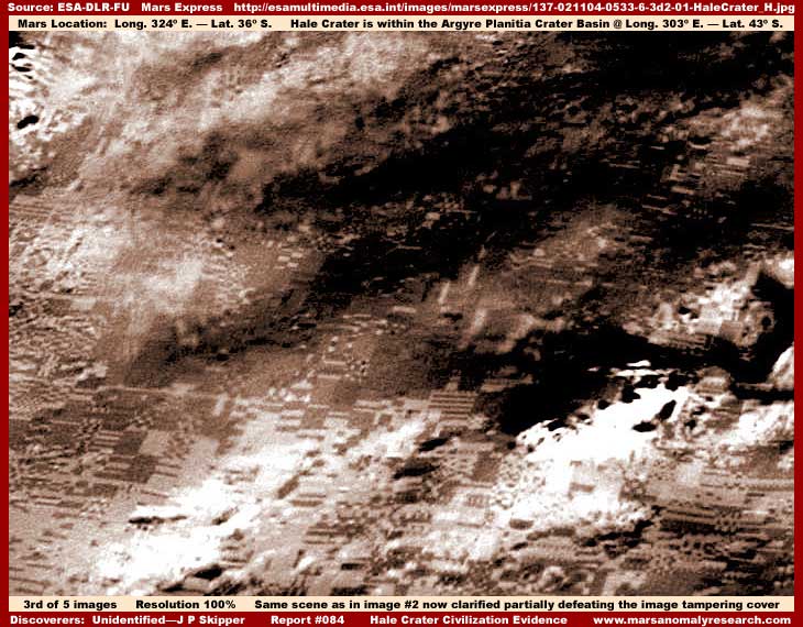
The net result is that the easily identified final fluffy smooth tampering applications tried but failed to completely hide the large dark blocks extending over the strip edges. It may give the impression that careless image tampering didn't quite hide civilization evidence in these spots. However, if any civilization evidence was ever at these locations, it was thoroughly hidden by the original grainy textured tampering which layers are so dense that nothing can be seen of even fairly large terrain features and the only things that can be seen are very large features like mountains, hills, impact craters, canyons, and finally the dark compression blocks.
In retrospect, as long as the secrecy agenda is inclined to deal with the cumbersome task of attempting to hide the truth they don't want us to know about via modifying and manipulating the original science data imaging on a massive scale, mistakes will be made just because of the sheer numbers and scale involved and small bits and pieces of truth may find its way through to us. However, when they convert over (and they will) to just making up and designing computer graphics generated terrain from scratch no longer needing to modify original exploration research imaging, even greater ignorance in our world societies and institutions will prevail.
The key will be when the data released for public consumption starts demonstrating really dramatic improvements in detail and clarity. Such "improvements" will be reported as due to advancements in camera, processing, and communications technology. Worse and most sickening, it will be believed and well received by a clueless mainstream with a preference to remain that way.
So their new and improved camera technology will end up serving the veil over the truth. We're all saying, where are the good photos, what is going on here? This is crapola? Well, we might not like the way they solve this.
edit on 25-9-2012 by Unity_99 because: (no reason given)
reply to post by Unity_99
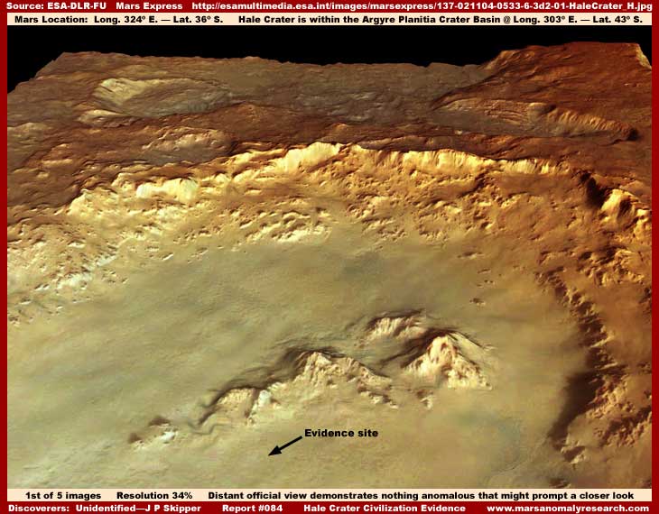
That's Hale Crater and a low res and manipulated pic. This is from the ESA of Hale Crater. Just Google Hale crater images and that web site is the only one with those pics.
esamultimedia.esa.int...
You need a better source.
That's Hale Crater and a low res and manipulated pic. This is from the ESA of Hale Crater. Just Google Hale crater images and that web site is the only one with those pics.
esamultimedia.esa.int...
You need a better source.
reply to post by dcmb1409
No its not. All those buildings are not due to an older photo. The public may be that stupid, but most of us here, aren't.
Oh, that newer glossy job I think I touched on what they are going to do with so called better equipment in my post above.
Yeah, its major tampering and major fraud, they need some jail to go with their coffee.
By the way, this is too important to just gloss over, so lets look at what a photo expert has to say, ie. Skipper.
www.marsanomalyresearch.com...
So they give artwork to the media? Interesting.
The rest of this article is interesting too.
www.marsanomalyresearch.com...
This image of it is beautiful isn't it. This appearance is a signature characteristic of the often visually stunning ESA Mars Express HRSC (High Resolution Stereo Camera) imaging as it is presented to the public and media. However, what we all need to be aware of is that this pretty picture for the public and media is partially art work and not be confused with the raw visual science data as seen by the Mars Express camera systems that would not have this information overlaid on it. This pretty look is accomplished right here on Earth by some heavy artificial processing and manipulation of the image to this effect.
So they give artwork to the media? Interesting.
The rest of this article is interesting too.
edit on 25-9-2012 by Unity_99 because: (no reason given)
reply to post by Unity_99
Did your expert discuss pixels? These pics have already been discussed here.
www.abovetopsecret.com...
Did your expert discuss pixels? These pics have already been discussed here.
www.abovetopsecret.com...
reply to post by dcmb1409
The photo's are art work, and if the thread you linked has any other conclusion, I would call it fraud too, if the people on it were drawing other conclusions and weren't ordinary citizens, and we can't prove those things here, but I can express that I don't believe alot of posters here are. Pixels have nothing to do with layering and compositting. All that means is they are conducting a higher resolution fraud on the surface of things.
The photo's are art work, and if the thread you linked has any other conclusion, I would call it fraud too, if the people on it were drawing other conclusions and weren't ordinary citizens, and we can't prove those things here, but I can express that I don't believe alot of posters here are. Pixels have nothing to do with layering and compositting. All that means is they are conducting a higher resolution fraud on the surface of things.
edit on 25-9-2012 by Unity_99 because: (no reason given)
new topics
-
Where should Trump hold his next rally
2024 Elections: 2 hours ago -
Shocking Number of Voters are Open to Committing Election Fraud
US Political Madness: 2 hours ago -
Gov Kristi Noem Shot and Killed "Less Than Worthless Dog" and a 'Smelly Goat
2024 Elections: 3 hours ago -
Falkville Robot-Man
Aliens and UFOs: 3 hours ago -
James O’Keefe: I have evidence that exposes the CIA, and it’s on camera.
Whistle Blowers and Leaked Documents: 4 hours ago -
Australian PM says the quiet part out loud - "free speech is a threat to democratic dicourse"...?!
New World Order: 5 hours ago -
Ireland VS Globalists
Social Issues and Civil Unrest: 5 hours ago -
Biden "Happy To Debate Trump"
2024 Elections: 6 hours ago -
RAAF airbase in Roswell, New Mexico is on fire
Aliens and UFOs: 6 hours ago -
What is the white pill?
Philosophy and Metaphysics: 7 hours ago
top topics
-
A Warning to America: 25 Ways the US is Being Destroyed
New World Order: 16 hours ago, 21 flags -
James O’Keefe: I have evidence that exposes the CIA, and it’s on camera.
Whistle Blowers and Leaked Documents: 4 hours ago, 12 flags -
Blast from the past: ATS Review Podcast, 2006: With All Three Amigos
Member PODcasts: 8 hours ago, 12 flags -
Australian PM says the quiet part out loud - "free speech is a threat to democratic dicourse"...?!
New World Order: 5 hours ago, 10 flags -
Biden "Happy To Debate Trump"
2024 Elections: 6 hours ago, 10 flags -
Mike Pinder The Moody Blues R.I.P.
Music: 8 hours ago, 8 flags -
Ireland VS Globalists
Social Issues and Civil Unrest: 5 hours ago, 5 flags -
RAAF airbase in Roswell, New Mexico is on fire
Aliens and UFOs: 6 hours ago, 5 flags -
What is the white pill?
Philosophy and Metaphysics: 7 hours ago, 5 flags -
Putin, Russia and the Great Architects of the Universe
ATS Skunk Works: 11 hours ago, 4 flags
active topics
-
Candidate TRUMP Now Has Crazy Judge JUAN MERCHAN After Him - The Stormy Daniels Hush-Money Case.
Political Conspiracies • 815 • : Annee -
Where should Trump hold his next rally
2024 Elections • 10 • : EmmanuelGoldstein -
President BIDEN's FBI Raided Donald Trump's Florida Home for OBAMA-NORTH KOREA Documents.
Political Conspiracies • 35 • : Threadbarer -
University of Texas Instantly Shuts Down Anti Israel Protests
Education and Media • 309 • : cherokeetroy -
Remember These Attacks When President Trump 2.0 Retribution-Justice Commences.
2024 Elections • 58 • : WeMustCare -
2024 Pigeon Forge Rod Run - On the Strip (Video made for you)
Automotive Discussion • 8 • : WhitewaterSquirrel -
Gov Kristi Noem Shot and Killed "Less Than Worthless Dog" and a 'Smelly Goat
2024 Elections • 28 • : cherokeetroy -
Shocking Number of Voters are Open to Committing Election Fraud
US Political Madness • 5 • : AwakeNotWoke -
The Acronym Game .. Pt.3
General Chit Chat • 7756 • : bally001 -
RAAF airbase in Roswell, New Mexico is on fire
Aliens and UFOs • 8 • : Skinnerbot