It looks like you're using an Ad Blocker.
Please white-list or disable AboveTopSecret.com in your ad-blocking tool.
Thank you.
Some features of ATS will be disabled while you continue to use an ad-blocker.

A Serious Discussion On The Cascadia Subduction Zone and Latest Studies
page: 11share:
reply to post by Olivine
Great work Olivine. This stuff really gets my mind puzzled!!!
I wonder why they (USGS) removed the ... OOPS.... never mind. It seems as if they cannot decide whether or not two tremors took place this morning in La Verne. They are now showing two again. lol
I always look on earthquake-report.com... to read the I felt it reports. I find them interesting to say the least. One I read caught my eye and made me laugh out loud. It's actually not a laughing matter and for reasons unknown to me as to why I chuckled.. here it is below.
The more I read the more I understood that although California people are used to tremors, this one felt different to them as a lot of peoples comment said just that.
I for one am awaiting a bigger thrust somewhere.?? I have no idea WHY though. The activity in the US seems to me as if it has picked up. Maybe it has around the world as well and maybe I am completely off, just seems as though anticipation of a big one is a thought/feeling that keeps creeping in.
ETA: This thread www.abovetopsecret.com... just popped up and now I am a little more concerned. One of our own ATS members are indeed scared from the quake this morning. Keep us posted Olivine and WC in regards to what you see and or hear in the next few days.
Great work Olivine. This stuff really gets my mind puzzled!!!
I wonder why they (USGS) removed the ... OOPS.... never mind. It seems as if they cannot decide whether or not two tremors took place this morning in La Verne. They are now showing two again. lol
I always look on earthquake-report.com... to read the I felt it reports. I find them interesting to say the least. One I read caught my eye and made me laugh out loud. It's actually not a laughing matter and for reasons unknown to me as to why I chuckled.. here it is below.
Glendora - It was awful. The scariest moment of my life. I was shaken out of bed. I am leaving town. The big one is coming!!!
The more I read the more I understood that although California people are used to tremors, this one felt different to them as a lot of peoples comment said just that.
San Dimas - Lived in CA entire life, this did not feel like a "normal" 3.7
I for one am awaiting a bigger thrust somewhere.?? I have no idea WHY though. The activity in the US seems to me as if it has picked up. Maybe it has around the world as well and maybe I am completely off, just seems as though anticipation of a big one is a thought/feeling that keeps creeping in.
ETA: This thread www.abovetopsecret.com... just popped up and now I am a little more concerned. One of our own ATS members are indeed scared from the quake this morning. Keep us posted Olivine and WC in regards to what you see and or hear in the next few days.
edit
on 19-9-2013 by MamaJ because: (no reason given)
I wonder why the residents there felt a dropping sensation? There were quite a few that said it didn't feel like the normal roll or jolt but rather a
dropping sensation.
Makes me wonder...
Makes me wonder...
reply to post by MamaJ
Hey MamaJ, I read the thread you linked. Thanks for that--I would have missed it since I don't wander far from the Fragile Earth forum, lol.
Those 2 quakes were very shallow--that would give a good jolt to people nearby. It could be that they represent a new fault, instead of a zone that has ruptured before, but that's just a guess.
The "downward" motion people mention was due to their location relative to the epicenter, and the type of seismic wave motion felt most strongly at that location.--not because the ground dropped down permanently.
The focal mechanisms of both quakes showed "strike-slip" motion (horizontal), with just a very tiny vertical component.
*******************************************
So the tremor in the Pacific Northwest continues on...
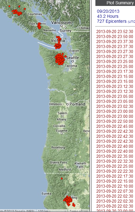
These thumbnails show the detected tremor on the 19th and 20th:
This is what the seismologists at the PNSN tremor blog have to say about this current activity:
It must be frustrating to have their model fall short of explaining this latest behavior; but maybe it will lead to a more full understanding of the mechanism driving the tremor and slow-slip.
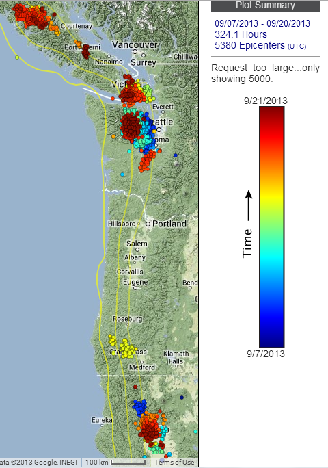
This map shows the migration of the tremor since 7 September.
(Blue is oldest, Dark Red is most recent. The Yellow lines, from left to right, show the depth to the plate interface--20, 30, & 40 kms down. Most of the tremor takes place between 25 & 40 kms.)
Hey MamaJ, I read the thread you linked. Thanks for that--I would have missed it since I don't wander far from the Fragile Earth forum, lol.
Those 2 quakes were very shallow--that would give a good jolt to people nearby. It could be that they represent a new fault, instead of a zone that has ruptured before, but that's just a guess.
The "downward" motion people mention was due to their location relative to the epicenter, and the type of seismic wave motion felt most strongly at that location.--not because the ground dropped down permanently.
The focal mechanisms of both quakes showed "strike-slip" motion (horizontal), with just a very tiny vertical component.
*******************************************
So the tremor in the Pacific Northwest continues on...
These thumbnails show the detected tremor on the 19th and 20th:
This is what the seismologists at the PNSN tremor blog have to say about this current activity:
Sep. 19, 2013:
What a strange ETS; if it really is one yet.
After almost dying out to nothing on Sep 17, the tremor picked up slightly and started moving back south to partially fill in the gap left at the end of Sep 13. Then today that section of tremor quit intirely and fairly strong tremor started up back south in the central Olympics.
Previous ETS events progress more or less smoothly, mostly in one direction with some minor reversals now and then. But this one seems to jump around quite a bit leaving gaps.
Our working model for an ETS is that a slow-slip slip front moves along strike at an average rate of about 10 km/day with streaks up and down dip and short reversals moving maybe ten times faster. The past 12 days have seen very little of this sort of pattern.
What next?
It must be frustrating to have their model fall short of explaining this latest behavior; but maybe it will lead to a more full understanding of the mechanism driving the tremor and slow-slip.
This map shows the migration of the tremor since 7 September.
(Blue is oldest, Dark Red is most recent. The Yellow lines, from left to right, show the depth to the plate interface--20, 30, & 40 kms down. Most of the tremor takes place between 25 & 40 kms.)
Here is a small quake up in the Queen Charlotte Islands area, just north of the PNW.
+-+21+Sep+13++17%3A49%3A45+UTC)&ll=52.48900,-132.03400&spn= 2,2&f=d&t=h&hl=e]Location in Google Maps
Derived from Event Data Source: USGS
Powered by QVSData
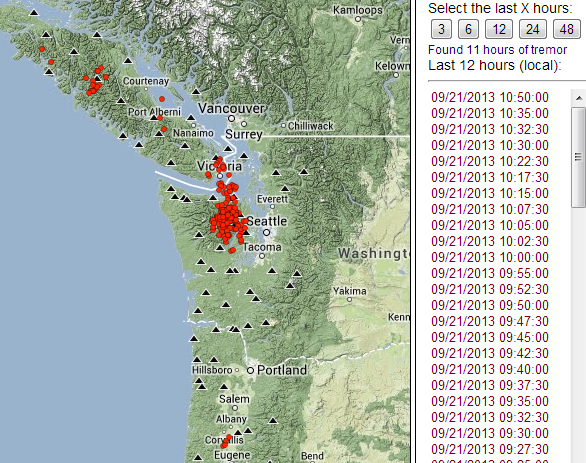
Looking at the past 12 hours on the real-time tremor page, it looks like the tremor is filling in "the gap" from earlier in the week.
Magnitude 4.2 - 170Km S Of Masset. Canada [T]
+-+21+Sep+13++17%3A49%3A45+UTC)&ll=52.48900,-132.03400&spn= 2,2&f=d&t=h&hl=e]Location in Google Maps
- Date-Time: Saturday, September 21, 2013 @ 17:49:45 UTC
- Earthquake location: 52.489°N, 132.034°W,
- Earthquake depth: 18.0 km
- Distances:
170km (105mi) S of Masset, Canada
233km (144mi) SSW of Prince Rupert, Canada
320km (198mi) SW of Terrace, Canada
547km (339mi) WNW of Campbell River, Canada
664km (412mi) SSE of Juneau, Alaska
- Event ID: at00mthlix
Derived from Event Data Source: USGS
Powered by QVSData
Looking at the past 12 hours on the real-time tremor page, it looks like the tremor is filling in "the gap" from earlier in the week.
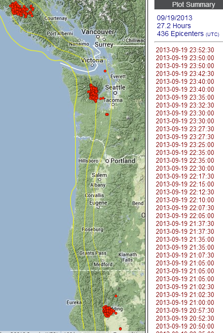
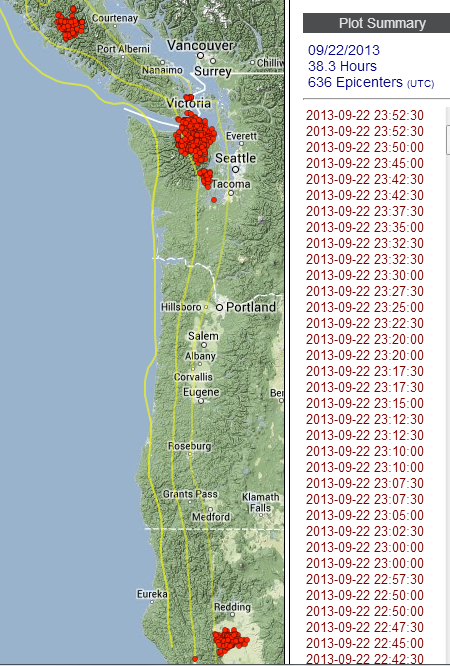
Okay. This is the tremor map for 21 September.
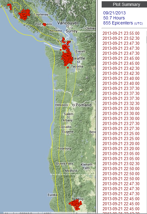
50.7 hours and 855 epicenters is a goodly bit of tremor for one day!
Normally, when the PNSN declares the "normal" episode is underway, it is confined to the northern Washington/Vancouver Island, BC region. But this? Of the 50+ hours of tremor today, only 18 hours were in WA--the rest was spread all along Van. Island and down in northern California. Strange.
Let's just hope the middle section of the CSZ doesn't start seeing tremor, too. Then, alarm bells would ring.
www.abovetopsecret.com...
The above thread is in reference to a Mail Tribune article about a geologist with the Oregon Office of Emergency Management speaking to an overflow crowd last Friday (20 Sept?) in Medford.. The article is about the after effects of a major quake... If this goes down I certainly hope our government has a better response than demonstrated with Katrina and those in Oregon actually listen and prepare as the article suggest.
S&F great informative thread, thanks.
reply to post by Olivine
Thanks again for keeping us up-to-date on the tremor maps/news!! I totally agree with you. This event is already strange...which is a bit unsettling.
Thanks again for keeping us up-to-date on the tremor maps/news!! I totally agree with you. This event is already strange...which is a bit unsettling.
That Oregon Story is crazy! Hopefully no time soon will that happen!!
Something has me puzzled, I wanted to ask, what fault line is this quake below connected to?
M 3.2 - 15km SSE of Lone Grove, Oklahoma earthquake.usgs.gov...
DYFI? - I
Time
2013-09-23 06:40:42 UTC-05:00
Location
34.042°N 97.225°W
Depth
5.0km
I have been wondering why these have not been showing up on Folkworm, then I realized it must not be on the New Madrid fault but another one.
Sitting on a major fault line, Oregon is “like an eight-and-a-half-month pregnancy, due any time now” for a major earthquake, a geologist with the Oregon Office of Emergency Management told an overflow crowd Friday in Medford. “We’re in the zone, and we’d darn well better get ourselves ready for it,” said Althea Rizzo, geology hazard coordinator for OEM. “A lot of you may have moved here from California to escape them, but the fact is, Oregon is earthquake country.”
Something has me puzzled, I wanted to ask, what fault line is this quake below connected to?
M 3.2 - 15km SSE of Lone Grove, Oklahoma earthquake.usgs.gov...
DYFI? - I
Time
2013-09-23 06:40:42 UTC-05:00
Location
34.042°N 97.225°W
Depth
5.0km
I have been wondering why these have not been showing up on Folkworm, then I realized it must not be on the New Madrid fault but another one.
reply to post by MamaJ
I don't know for certain. This geologic map of Oklahoma looks like that Mag 3.2 should be near the SE end of something called the "Criner Uplift".
For a list of quakes in Oklahoma, try the Leonard Geophysical Observatory.
FYI, that link above is only a one page PDF, but it was really slow to load, for some reason.
(probably just an issue with my compy)
*****************************
Well, it is officially, Septremor.
From the Pacific Northwest Seismic Network current tremor event page:
Read more at the link above.
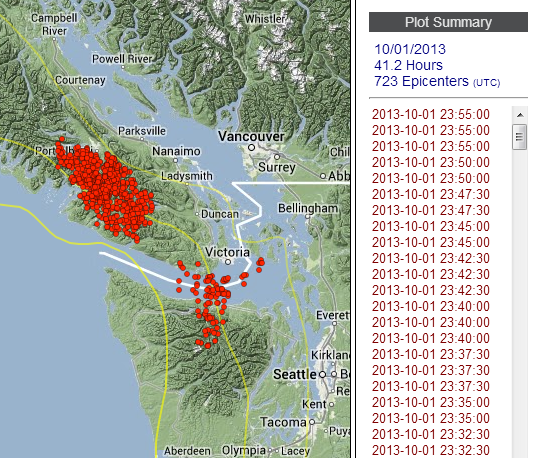
This image shows the tremor from yesterday. source
Early again...I believe that makes the ETS early 3 of the last 4 cycles.
I don't know for certain. This geologic map of Oklahoma looks like that Mag 3.2 should be near the SE end of something called the "Criner Uplift".
For a list of quakes in Oklahoma, try the Leonard Geophysical Observatory.
FYI, that link above is only a one page PDF, but it was really slow to load, for some reason.
(probably just an issue with my compy)
*****************************
Well, it is officially, Septremor.
From the Pacific Northwest Seismic Network current tremor event page:
And...
Sep 22, 2013:
OK, it is for real now. No more messing around with gaps and skips and fades and questions. It looks like the real thing over the past couple of days.
If this is not enough confusion going on it seems that other parts of Cascadia are trying to get into the act also.
Read more at the link above.
This image shows the tremor from yesterday. source
Early again...I believe that makes the ETS early 3 of the last 4 cycles.
edit on 9/23/2013 by Olivine because: (no reason given)
So 503 tremors today! That's a whole lot for a 24 hr period.
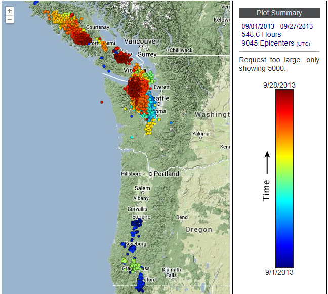
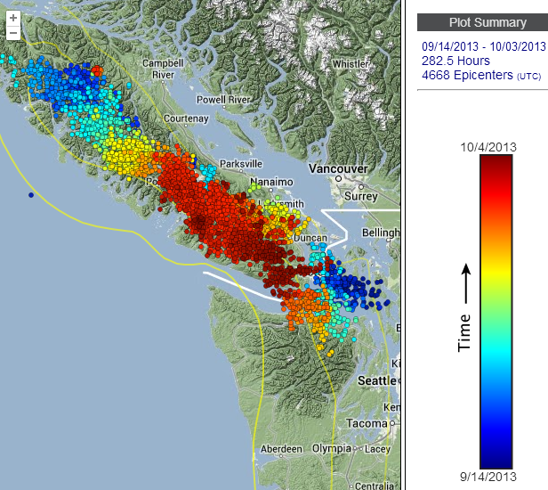
tremor map link
If you go to the above link and put in a time range for the past month (by color), it gives a very clear impressions of how the tremors are migrating. It seems like two clusters. The first one is in Puget Sound and is traveling to the NW. The second is centered under Vancouver Island and traveling to the SE. It appears that perhaps these have met in the middle, and you can see (dark red) that many of those tremors today were centered there. I wouldn't be surprised to see a large quake off the Southern shore of Vancouver Island soon. This is NOT based on anything scientific, just seems to make sense to me.
The tremor under the northern end of the subduction zone appears to be ongoing, and the gap between the northern most pocket of tremor and the
southern one looks to be closing near Victoria.
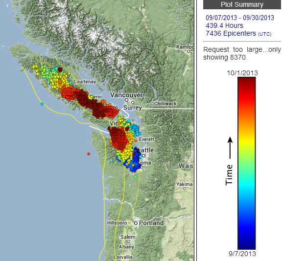
source(set to show range 7 Sept. - 30 Sept, N. VI, VI, N. WA & color vs. time)
No interesting quakes in the vicinity yet, but I'm with you Westcoast, it wouldn't surprise me to see one.
source(set to show range 7 Sept. - 30 Sept, N. VI, VI, N. WA & color vs. time)
No interesting quakes in the vicinity yet, but I'm with you Westcoast, it wouldn't surprise me to see one.
reply to post by Olivine
Hmm, well the "gap" still isn't closed, but yesterday the tremor did make a decided movement updip (shallower--toward the locked area).
source
Hmm, well the "gap" still isn't closed, but yesterday the tremor did make a decided movement updip (shallower--toward the locked area).
source
reply to post by Olivine
Yes....and now there are the quakes.
The first one (1.8 mag) this morning was right under the area you spoke of near Victoria. And at a depth that indicates it is coming from the locked zone, and the ETS. Important note is that this is on the down-dip.
The next two were a bit larger (2.5, 2.2 mags) on the edge of the OTHER migrating cluster of tremors. These were ALSO deep, indicating that they originated in the locked zone, where the tremors are and were on the up-dip.
map of quakes
SO...we now have three quakes, seeming to originate from these two clusters whithin the locked zone and on seperate dips. I would say that this is getting VERY interesting now.
Add to that the USGS page: USGS partial shutdown (I tried to do a screen shot, but for some reason I am unable to upload images)
John Vidale from the PNSN assures us that they are still monitoring things from the University of Washington. This will, however impact near-future funding.
edit on 2-10-2013 by westcoast because: (no reason given)
reply to post by westcoast
Another small earthquake in the area. Mag 2.1
It hasn't been reviewed yet, as I post this. And the depth seems a bit too shallow to be on the plate interface, for this location, but the focal mechanisms given are interesting.
If you click on the "technical data" tab, the nodal plane A of "Strike 345°, Dip 25°, Rake 170°" could be consistent with the subduction fault plane.
(FYI, the images on this page seem to be mixed up. The top image corresponds to the data in 'Solution 2', and the bottom beachball goes with the data in 'Solution 1')
Here is a pic of the little snap, from PB.B928.EHZ:
source
Another small earthquake in the area. Mag 2.1
It hasn't been reviewed yet, as I post this. And the depth seems a bit too shallow to be on the plate interface, for this location, but the focal mechanisms given are interesting.
If you click on the "technical data" tab, the nodal plane A of "Strike 345°, Dip 25°, Rake 170°" could be consistent with the subduction fault plane.
(FYI, the images on this page seem to be mixed up. The top image corresponds to the data in 'Solution 2', and the bottom beachball goes with the data in 'Solution 1')
Here is a pic of the little snap, from PB.B928.EHZ:
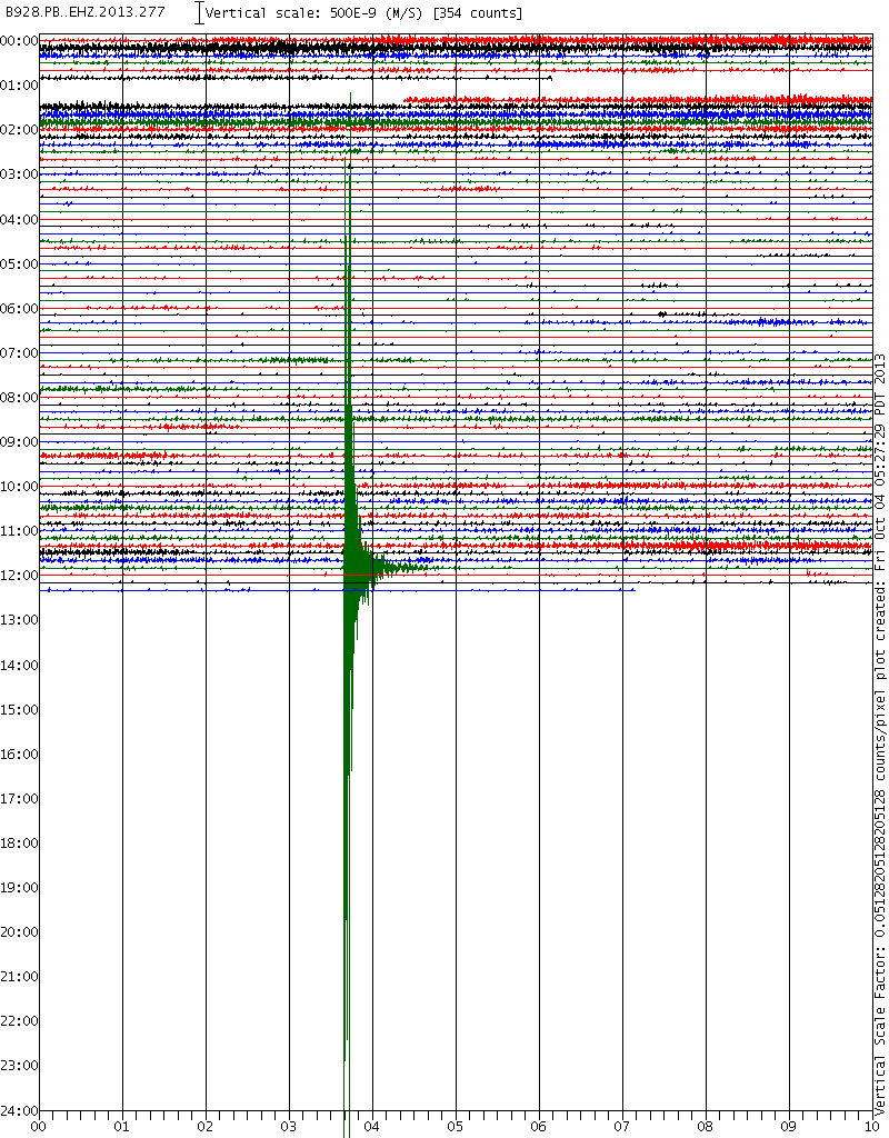
source
edit on 10/4/2013 by Olivine because:
fixing error
This image shows just the northern end of the CSZ, and it's tremor during this episode.
tremor map
It shows the updip trend (in the reds, closest to the water) over the past few days.
Here is what the PNSN has to say about the latest movement:
It goes on...
So, if this slow-slip event is going to move the surface as much as previous episodes have, it still has a 5-6 mm more to go.
But this event has been quirky from the beginning: coming early, "jumping" around, along strike, splitting, then filling gaps, etc, so it may not behave in the same manner.
I'm certain there is something to be learned about precurser patterns before large megathrust quakes from this tremor and slow-slip---I just really wish that "something" would reveal itself.
ETA: I just wanted to note that the technical data page I linked in the proceeding post has disappeared.
Strange--why post it and then delete the entire page?
If the figures were modified just show that. When they pull the data entirely, it makes me think they are trying to hide info....either that or change your software to not automatically generate and post focal mechanisms.
Oh yeah, after review, the quake was upgraded to mag 2.3, with the depth still at 5kms. The depth uncertainty increased from +/- 17.xx kms to +/- 35.24 kms.
tremor map
It shows the updip trend (in the reds, closest to the water) over the past few days.
Here is what the PNSN has to say about the latest movement:
There is a hint that over the past couple of days the single batch that now extends from northwest of Port Alberni down to Victoria has shifted slightly up-dip and strengthened in the south while becoming weaker in the north. During this period there have been times with very strong tremor on south-central Vancouver Island stations. To this seismologists untrained eye it seems that some of the GPS station in the northern Olympics and Southern Vancouver Island are showing changes. Surely the GPS gurus should be able to confirm slip in this area, at least over the past week or so. So, what next?
Anyones guess. It is not likely to move back south across the straits since that region has already had pretty strong tremor a week or so ago. It has already been farther north. Therefore, there is nothing for it to do but stay where it is and slowly die out.
It goes on...
Or.... maybe not. I just got word from Herb Draget that this ETS may not be near over.
Over the past 9 days we have seen surface deformation at a number of sites. Of the GPS sites that are included in our network analyses, the largest horizontal offsets we see up to now are about 5 to 6 mm (at SC03 and P424). Our horizontal offsets at ALBH (Victoria GPS site) are still only about 1/2 of the usual value so maybe there is still some slip to come beneath southern Vancouver Island?
So, if this slow-slip event is going to move the surface as much as previous episodes have, it still has a 5-6 mm more to go.
But this event has been quirky from the beginning: coming early, "jumping" around, along strike, splitting, then filling gaps, etc, so it may not behave in the same manner.
I'm certain there is something to be learned about precurser patterns before large megathrust quakes from this tremor and slow-slip---I just really wish that "something" would reveal itself.
edit on 10/4/2013 by Olivine because: (no reason given)
ETA: I just wanted to note that the technical data page I linked in the proceeding post has disappeared.
Strange--why post it and then delete the entire page?
If the figures were modified just show that. When they pull the data entirely, it makes me think they are trying to hide info....either that or change your software to not automatically generate and post focal mechanisms.
Oh yeah, after review, the quake was upgraded to mag 2.3, with the depth still at 5kms. The depth uncertainty increased from +/- 17.xx kms to +/- 35.24 kms.
edit on 10/4/2013 by Olivine because: (no reason given)
This is a curious development.
According to the tremor blog 2013 at PNSN, the tremor ended on October 8th.
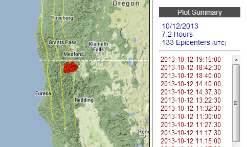
Yesterday, there was a moderate cluster of tremor under northern California, just west of Yreka.
Since the update last evening, the tremor seems to have resumed under the southern tip of Vancouver Island, British Columbia. Real-time tremor(click the "12" button)
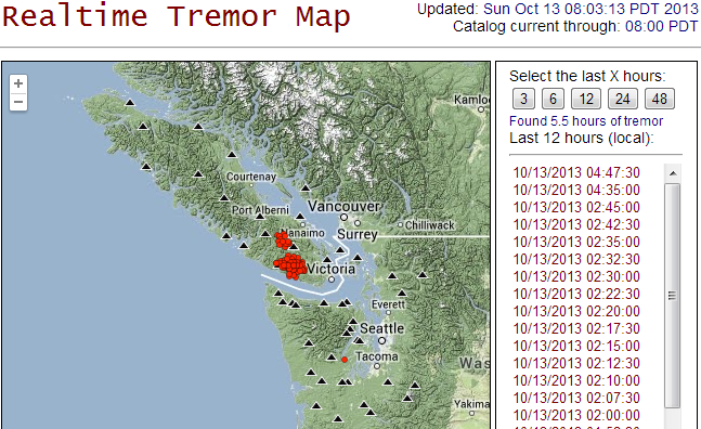
Maybe it isn't over just yet. Strange, I don't recall every reading of a past episode that quit for days, then restarted. This years' ETS has been anamolous, from its early start, to strange "jumpiness" & progress.
According to the tremor blog 2013 at PNSN, the tremor ended on October 8th.
Oct 11,2013:
I think it is time to call it over. The last day with any locatable tremor was Oct 8. So it went from Sep 7 - Oct 8, just over a month which is fairly typical for ETS events in this area. However, it was not as energetic has most previous events but extended over a larger area. We will need to wait untill the geodesy types figure out what the slip was for this event. I suspect it will not be as much slip at any individual place but may extend over a larger area.
Yesterday, there was a moderate cluster of tremor under northern California, just west of Yreka.
Since the update last evening, the tremor seems to have resumed under the southern tip of Vancouver Island, British Columbia. Real-time tremor(click the "12" button)
Maybe it isn't over just yet. Strange, I don't recall every reading of a past episode that quit for days, then restarted. This years' ETS has been anamolous, from its early start, to strange "jumpiness" & progress.
Just lurked into this thread and although it is early and I just awoke, only a few sips of coffee so far, however I see California all over USGS and
will patiently await for Olivine and Westcoast.
It's a good thing I don't have your phone numbers. lol A 4 am text may be a little irritating even if it's a warning to WAKE UP AND CHECK OUT THIS SWARM.
It's a good thing I don't have your phone numbers. lol A 4 am text may be a little irritating even if it's a warning to WAKE UP AND CHECK OUT THIS SWARM.
While reading the PNSN facebook page, I noticed reference to a NHK World documentary concerning the Nankai trench, slow earthquakes and their
relationship to megathrust quakes.
I've found it on youtube. It's from a series titled MegaQuake, and this episode is called Nankai Trough: Deciphering Earth's Signals--it is completely fascinating (if you're into slow-slip/ETS and subduction zone earthquakes ).
A few key points made in the film:
1. Slow-slip occurred continuously for one month before the Tohoku earthquake of 11 March 2011.
2. That slow-slip was located up-dip of the eventual hypocenter of the Mag 9.0.
3. Ocean bottom seismometers and GPS are necessary to monitor all of the slow-slip taking place. Not just the tremor we can detect from land-based instrumentation.
The film runs 49 minutes, but if you don't have all that time, I've noted some key times to skip to, below.
A. At 10:10 into the film slow earthquakes are defined.
B. Very nice animation at 11:30.
C. From 18:50 to 20:20 is a fascinating laboratory experiment replicating the slow-slip and the main shock of the Tohoku EQ.
D. @ the 26:00 to 30:30 they discuss Cascadia with Herb Dragert of the Pacific Geoscience Center, Canada.
I believe the research of ETS/slow-slip/slow earthquakes (whatever they decide to call it, lol) along with GPS observations, will be the key to "predicting" an impending rupture on megathrust zones in the future.
Enjoy.
edit on 10/23/2013 by Olivine because: spelling
reply to post by Olivine
Hello Olivine. I watched the Nankai trough video. Very good program. Defintely implications and applications for the Cascadia area.
Had no idea about part of the plate breaking apart and heading into another direction because of the Isthmus.
Have you been watching the Cascadia area lately?
A few 4s up at the northern edge of Juan De Fuca at about 10 km and some uptick in northern california near the Triple Junction.
Is everything being tugged north a little harder because of the Alaska quake?
Also, last time I checked the PNSN site, the ETS looked like it has finished.
A little early, isn't it?
edit on 11-11-2013 by r4winds because: forgot to relate to original post content
reply to post by r4winds
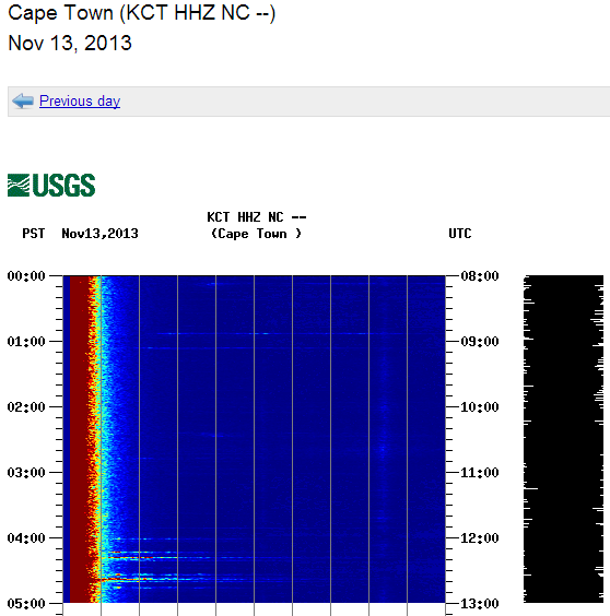
Yes, there has been an uptick in activity in Cascadia. Just a few minutes ago, this Mag 4.2 out near the Gorda ridge, and another (probably from the same spot) is coming across the seismos right now**.
**still not listed, but you can clearly see the mag 4.2 at 12:17 UTC, and then the larger earthquake at 12:36/12:37 UTC on fB046.PB.BHZ.
Both quakes can also be seen on this spectrogram image from station KCT.HHZ on the Northern California network. (all of the publicly available NC spectros can be accessed from that link.)
The ETS in the northern section did come early again, and it was relatively short-lived.
As long as the activity stays in the offshore plates (Gorda, Juan de Fuca), it indicates deformation internal to those plates, further indicating that the plate interface is still tightly locked.
I guess that is a good thing.
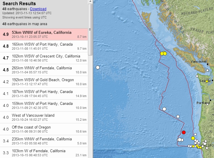
This map shows the past 5 weeks in the region, mag 2+, search map link.
I missed that oddball Mag 4.0 way out in the Pacific when it happened on 24 October--that's a strange one.
Yes, there has been an uptick in activity in Cascadia. Just a few minutes ago, this Mag 4.2 out near the Gorda ridge, and another (probably from the same spot) is coming across the seismos right now**.
**still not listed, but you can clearly see the mag 4.2 at 12:17 UTC, and then the larger earthquake at 12:36/12:37 UTC on fB046.PB.BHZ.
Both quakes can also be seen on this spectrogram image from station KCT.HHZ on the Northern California network. (all of the publicly available NC spectros can be accessed from that link.)
The ETS in the northern section did come early again, and it was relatively short-lived.
As long as the activity stays in the offshore plates (Gorda, Juan de Fuca), it indicates deformation internal to those plates, further indicating that the plate interface is still tightly locked.
I guess that is a good thing.
This map shows the past 5 weeks in the region, mag 2+, search map link.
I missed that oddball Mag 4.0 way out in the Pacific when it happened on 24 October--that's a strange one.
edit on 11/13/2013 by Olivine because: Add a map
edit on 11/13/2013 by Olivine because: to add an
additional image to verify I wasn't imaging that 2nd offshore northern California earthquake
new topics
-
HOUSE VOTES 320-91 TO BAN CHRISTIAN BELIEFS IN AMERICA
Political Issues: 1 hours ago -
Dugin's interview and the West's complete ignorance of Russia
New World Order: 3 hours ago -
Thousands of Anti-Semitic People Protest Israel's government in Tel Aviv
Middle East Issues: 3 hours ago -
Mysterious Spiral 'UFO' Sightings Reported Across US, Europe
Aliens and UFOs: 10 hours ago
top topics
-
The Dark Pyramid of Alaska and the Why Files take on the subject
Whistle Blowers and Leaked Documents: 14 hours ago, 13 flags -
Thousands of Anti-Semitic People Protest Israel's government in Tel Aviv
Middle East Issues: 3 hours ago, 5 flags -
Mysterious Spiral 'UFO' Sightings Reported Across US, Europe
Aliens and UFOs: 10 hours ago, 3 flags -
Dugin's interview and the West's complete ignorance of Russia
New World Order: 3 hours ago, 3 flags -
HOUSE VOTES 320-91 TO BAN CHRISTIAN BELIEFS IN AMERICA
Political Issues: 1 hours ago, 1 flags
active topics
-
UN Estimates Rebuilding Gaza Will Cost Up To 40 Billion Dollars
Middle East Issues • 107 • : YourFaceAgain -
Candidate TRUMP Now Has Crazy Judge JUAN MERCHAN After Him - The Stormy Daniels Hush-Money Case.
Political Conspiracies • 1195 • : Oldcarpy2 -
Really Unexplained
Paranormal Studies • 105 • : Beesnestbomber -
Thousands of Anti-Semitic People Protest Israel's government in Tel Aviv
Middle East Issues • 19 • : KrustyKrab -
Mysterious Spiral 'UFO' Sightings Reported Across US, Europe
Aliens and UFOs • 12 • : pianopraze -
Dugin's interview and the West's complete ignorance of Russia
New World Order • 5 • : Oldcarpy2 -
Post A Funny (T&C Friendly) Pic Part IV: The LOL awakens!
General Chit Chat • 7154 • : underpass61 -
HOUSE VOTES 320-91 TO BAN CHRISTIAN BELIEFS IN AMERICA
Political Issues • 6 • : Disgusted123 -
Are you ready for the return of Jesus Christ? Have you been cleansed by His blood?
Religion, Faith, And Theology • 31 • : mysterioustranger -
Farmers jailed without due process
General Conspiracies • 21 • : BernnieJGato