It looks like you're using an Ad Blocker.
Please white-list or disable AboveTopSecret.com in your ad-blocking tool.
Thank you.
Some features of ATS will be disabled while you continue to use an ad-blocker.

Unearthing Antarctica's mysterious mountains
page: 13
share:
Once again, Antarctica is proving to be a wealth of information. This new study has already revealed a new extension of a rift system, and I'm sure
many new discoveries are to come about the creation of mountain ranges and our earth once they are able to drill through the ice to retrieve rock
samples.
This sort of reminds me of what is going on at Lake Vostok, but instead of a lake, it's a mountain buried under millions of years of ice, and it may hold clues to the mysteries of our earth.
www.earthmagazine.org...
This sort of reminds me of what is going on at Lake Vostok, but instead of a lake, it's a mountain buried under millions of years of ice, and it may hold clues to the mysteries of our earth.
www.earthmagazine.org...
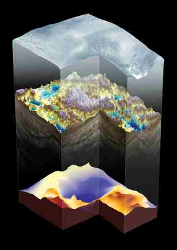
In 1958, geologists discovered a mountain range buried more than a kilometer beneath the East Antarctica Ice Sheet. For more than half a century, the origins of the Gamburtsev Subglacial Mountains have proven to be a geological puzzle, but a new study may have finally solved the enigma, and simultaneously given geologists a new understanding of mountain-building processes.
The Gamburtsevs lie under the highest point in Antarctica, the 4,000-meter-high Dome Argus Plateau. The mountain range, in the middle of an ancient continental craton, has a thick, crustal root and high topography, which has made the Gamburtsevs the least-understood tectonic feature on Earth for the past 50 years.
“The reason why the Gamburtsevs are so enigmatic is that stable cratons are generally low-lying features with no huge mountain ranges atop,” says Fausto Ferraccioli, a geophysicist at the British Antarctic Survey in Cambridge, England.
The Gamburtsevs are completely covered by ice, preventing scientists from recovering physical rock samples. Earlier studies that determined the root — all that remains of an earlier mountain chain — was at least Precambrian in age relied on indirect evidence: outcrops exposed to the north of the mountains, detrital zircons retrieved from ice cores, and seismic measurements that revealed a crustal thickness of 45 to 60 kilometers. Elsewhere in East Antarctica, the average crustal thickness is about 35 to 40 kilometers.
Ferraccioli and his colleagues used two Twin Otter aircraft equipped with ice-penetrating radar, laser-ranging systems, gravity meters and magnetometers to collect data over a 3-million-square-kilometer area between the South Pole and the Lambert Glacier. The data revealed a previously unknown extension of the East Antarctic Rift System — a 2,500-kilometer-long fracture that extends from East Antarctica across the ocean to India, which, when active, resembled today’s East African Rift System — making it the longest fossil rift system on Earth.
“The next steps will be to assemble a team to drill through the ice into the mountains to obtain the first rock samples from the Gamburtsevs,” says Robin Bell, a geophysicist at Columbia University’s Lamont-Doherty Earth Observatory and a co-author on the study. “Amazingly, we have samples of the moon but none of the Gamburtsevs.”
The rock samples will help narrow the timeline of root formation, reactivation, rifting and uplift. Nonetheless, Veevers wrote in Nature, “Ferraccioli and colleagues’ study provides the first comprehensive model to explain how a ragged topography can form in an ice-covered continental interior by modification of the underlying crust and lithosphere.”
What I have found most striking about the scans and details of this mountain range is the degree of sharp relief and detail they're seeing in the
rock formations. It apparently indicates that that area froze and just remained frozen, as opposed to the grind and shift of ice over the ages. How
exciting. That could mean that the landscape below the Ice is far more intact, if not a little flattened, than one might have thought.
I think we ought to make it something of a priority to develop fast moving tunnelers and boring machines to start seeing what is actually under that ice. There must be a way to do it fairly cleanly. After all, it's just a mater of melting water to form the tunnel and moving out the water that produces right?
WIth a land mass a hair larger than all of the Continental United States and Mexico combined, we can't even say the surface has been scratched yet. We haven't even found the surface TO scratch. I'd love to see them really move with all this. Heck. once they have a fairly decent area cored out beneath the Ice, Antarctica isn't even that hostile anymore. Underground is Underground and Ice only gets so cold....nothing like the brutal surface conditions.
reply to post by Wrabbit2000
The tunnel boring idea you had is pretty good. There would of course be safety concerns because of the chances of collapse, but it does have some potential. For all we know, they may already be doing something like this. A city built under the ice is actually not a bad idea. They could use a study such as this to find an existing cave system in the mountains, and bore thru the ice to expose a perfect Antarctic retreat.
The tunnel boring idea you had is pretty good. There would of course be safety concerns because of the chances of collapse, but it does have some potential. For all we know, they may already be doing something like this. A city built under the ice is actually not a bad idea. They could use a study such as this to find an existing cave system in the mountains, and bore thru the ice to expose a perfect Antarctic retreat.
edit on
7-2-2012 by isyeye because: (no reason given)
new topics
-
For Votes - President BIDEN Opens ObamaCare Health Ins to Illegal Aliens Eff Nov 1st 2024.
2024 Elections: 4 hours ago -
EPA sues San Francisco for dumping billions of gallons of sewage into Pacific Ocean
US Political Madness: 4 hours ago -
Prophets versus priests; - Getting God's help
Religion, Faith, And Theology: 6 hours ago -
UN Estimates Rebuilding Gaza Will Cost Up To 40 Billion Dollars
Middle East Issues: 8 hours ago -
Study Finds The More Covid Vaccine Doses You Have, the More Likely You Are to Get Covid
Medical Issues & Conspiracies: 9 hours ago -
Wounded Orangutan seen using a Plant as Medicine for the First Time
Fragile Earth: 10 hours ago -
Democratic Rep. Henry Cuellar and wife indicted on federal bribery charges
US Political Madness: 10 hours ago -
An AI-controlled fighter jet took the Air Force leader for a historic ride
Military Projects: 10 hours ago -
SEC shuts down Trump Media auditor, BF Borgers, over fraud
Mainstream News: 11 hours ago -
Farmers jailed without due process
General Conspiracies: 11 hours ago
3