It looks like you're using an Ad Blocker.
Please white-list or disable AboveTopSecret.com in your ad-blocking tool.
Thank you.
Some features of ATS will be disabled while you continue to use an ad-blocker.

Notice: You Too Can Participate in the Community Seismic Network!
page: 15
share:
If you live in Southern California, that is.
The Community Seismic Network is a cool new network of localized, home-based seismograph sensors, which can provide more exacting data to scientists and emergency agencies for producing shake maps after an earthquake.
From their Project Overview page:
Here is a picture of one of these:
Taken from this article here:
www.seismolab.caltech.edu...
Sounds like we need these wizmos all over. Especially near the New Madrid. But if a massive quake happens there, forget the shake maps and send MAJOR HELP immediately to Memphis. Cause they're gonna need it more than they do shake maps. Let's not be Katrina all over again if this happens. And I would not advise trying to disarm any rednecks, or you may find YOURSELF without an arm.
The Community Seismic Network is a cool new network of localized, home-based seismograph sensors, which can provide more exacting data to scientists and emergency agencies for producing shake maps after an earthquake.
From their Project Overview page:
We expect first responder organizations—police, fire, water and power agencies, telecom providers, large building operators, school administrators, pipeline operators, public health, Red Cross—to combine our shake maps with internal infrastructure maps in order to make decision about where, when, and how to respond. For example, a subscriber agency might have a database of maximum acceleration forces that each key structure is designed to withstand; this database could be compared against a shake map to determine which structures are most likely to have been damaged and the projected impact.
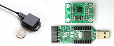
Our devices are designed to be attached to a floor, wall, or desk, and are connected via a six-foot cable to an existing, internet-connected stationary computer with an unused USB port. A small software application runs on the PC to collect vibration data many times a second, and if strong shaking is detected, an alert is sent over the internet to a remote service that analyses reports from all of the devices to determine that an earthquake has just occurred and produce a shake map. Even with a severe, nearby earthquake, the remote CSN service should receive useful data in the few seconds before internet service fails, construct a shake map, and deliver it to subscribers.
Here is a picture of one of these:
Taken from this article here:
www.seismolab.caltech.edu...
Sounds like we need these wizmos all over. Especially near the New Madrid. But if a massive quake happens there, forget the shake maps and send MAJOR HELP immediately to Memphis. Cause they're gonna need it more than they do shake maps. Let's not be Katrina all over again if this happens. And I would not advise trying to disarm any rednecks, or you may find YOURSELF without an arm.
This is a pretty neat thing they're doing. Too bad they currently want people in the Pasadena area or else I would've applied right away.
TA, is there a possibility we could start a similar program in NMZ?
I may well be too far away to qualify, since I am in E KY. We've gotten a good rumble a couple months back. But we certainly have plenty of members over on www.abovetopsecret.com... thread that would make excellent candidates. Will send them this thread in reference.
I may well be too far away to qualify, since I am in E KY. We've gotten a good rumble a couple months back. But we certainly have plenty of members over on www.abovetopsecret.com... thread that would make excellent candidates. Will send them this thread in reference.
I was ready to join too, then read further and saw it wasn`t for this area.
It sounds like a great idea!
It sounds like a great idea!
new topics
-
Putin, Russia and the Great Architects of the Universe
ATS Skunk Works: 3 hours ago -
A Warning to America: 25 Ways the US is Being Destroyed
New World Order: 7 hours ago
top topics
-
President BIDEN's FBI Raided Donald Trump's Florida Home for OBAMA-NORTH KOREA Documents.
Political Conspiracies: 13 hours ago, 31 flags -
A Warning to America: 25 Ways the US is Being Destroyed
New World Order: 7 hours ago, 13 flags -
Is AI Better Than the Hollywood Elite?
Movies: 14 hours ago, 4 flags -
Maestro Benedetto
Literature: 14 hours ago, 1 flags -
Putin, Russia and the Great Architects of the Universe
ATS Skunk Works: 3 hours ago, 1 flags
5