It looks like you're using an Ad Blocker.
Please white-list or disable AboveTopSecret.com in your ad-blocking tool.
Thank you.
Some features of ATS will be disabled while you continue to use an ad-blocker.

Help Identify This Installation
page: 12
share:
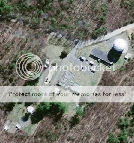
Can anyone tell me what this installation is used for? I appreciate you help. Thanks
[edit on 19-6-2010 by METACOMET]
[edit on 19-6-2010 by METACOMET]
Originally posted by METACOMET
Can anyone tell me what this installation is used for? I appreciate you help. Thanks
[edit on 19-6-2010 by METACOMET]
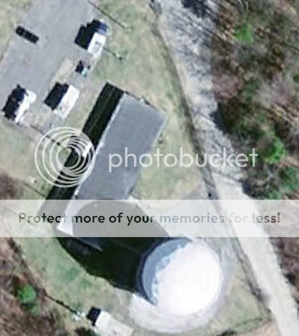
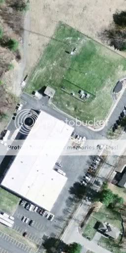
I believe it would be a weather monitoring station. The white balls are called Radomes en.wikipedia.org... it is either a microwave dish or a radar. I am betting a radar for monitoring weather.
[edit on 19-6-2010 by hornum]
[edit on 19-6-2010 by hornum]
Sorry friend not too sure what it could be. However I did used to live in the middle of Baltimore/Washington, close to NSA HQ, and you could see a lot
of those large white golf-ball looking things from the side of Route 32. I'm sure they are very common, not sure what they are used for though.
Thanks guys! Wouldn't surprise me if it were a weather station.
Strange thing about it that raised a few flags for me is that it is inside a 2k acre National Wildlife Refuge. It is right in the middle of the refuge, but it isn't part of it.
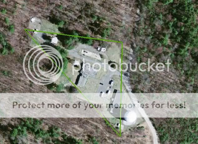
300 yard dirt runway
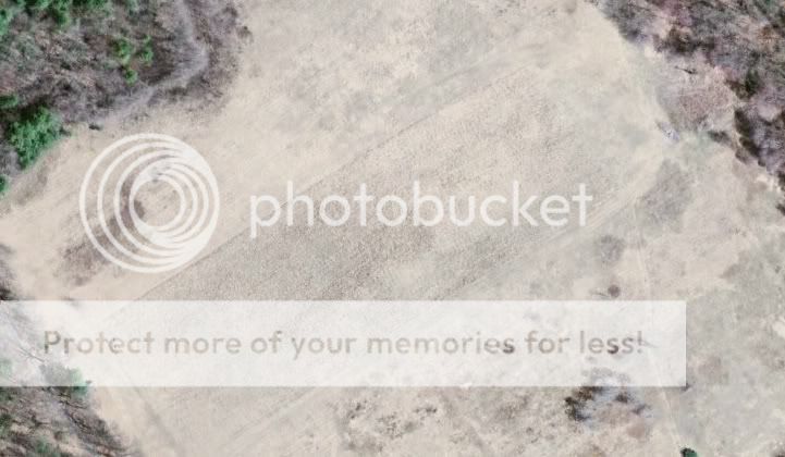
The dirt road that leads to all this begins from a multi-state fema command center.
I'm just curious about this because I recently walked in here with my dogs and got a gun pulled on me by a NWR Officer. He had local police, sheriff and DHS police with him. I was fined $200 bucks. Pretty tight security.
Strange thing about it that raised a few flags for me is that it is inside a 2k acre National Wildlife Refuge. It is right in the middle of the refuge, but it isn't part of it.
300 yard dirt runway
The dirt road that leads to all this begins from a multi-state fema command center.
I'm just curious about this because I recently walked in here with my dogs and got a gun pulled on me by a NWR Officer. He had local police, sheriff and DHS police with him. I was fined $200 bucks. Pretty tight security.
Already been stated....
Edited
[edit on 19-6-2010 by BlastedCaddy]
Edited
[edit on 19-6-2010 by BlastedCaddy]
First, what is the exact location?
What type of road leads to the location?
How close was the perimeter fence from the nearest building? Were there any signs of any kind on the perimeter fence? How high was the perimeter fence, and was there any barbed or concertina wire at the top of the fence?
How many personnel and vehicles did you see? What types of vehicles did you see? Is there any significant frequency of travel of vehicles to the site?
Try to recall to specifically recall how many of what kind of people you saw. What were the security personnel wearing - uniforms (police, security, military), or plain clothes, Are you sure there were local law enforcement personnel present, as that seems seriously out of place for any type of Federal facility. Who wrote the ticket, and what jurisdiction was responsible for receiving your $200. For what specific offense were you sited? What was the location designated on your ticket in reference to you violation - some identified location must be listed on the ticket. You might even contact the sheriff's office covering the area and simply ask what facility you were cited for violating. If it is a non-classified function, they may simply tell you. If possible, scan the ticket and post it, as that could be helpful.
Do the best you can in answering these questions and I will try to give you my best answer. One other thing, if you take a portable radio to within say a tenth of a mile of the radome, then search through the AM and FM channels, if it is an active radome you may pick up an interference pattern as the radar sweeps its pattern. Most radars of this apparent radome will be using an 8-second or so sweep frequency, so it should be easy to identify the sweep. If that doesn't work, also try turning your cell phone on, and leaving the dial tone on. It can pick up some frequencies of radars. If you can identify the radar in the radome as being active, that gives you a significant clue.
Answers would assist the process of identification of the site.
they have an instalation with those golf balls in goonhilly (not sure if thats spelt right) in cornwall uk, as well as some near me in sydney, the
ones in uk are a telecom /military instalation is was told, something to do with listening in to everything and the one here in aus is run by another
telecommunication company cold optus
I, too, would be interested in knowing some more. Does look like an odd station and to be in the middle of a Wildlife Refuge just seems odd. We have a
few of those in my area ( Wildlife Refuges ) but nothing with a government compound in the center of ( or even close by )
I am also puzzled that you walked near or onto the property and got cited / ticketed for it. Were there any signs stating it was a government facility? Any fences you could see? Personally, I would of fought the ticket if there wasn't.
There shouldn't be a crime to be walking on a Wildlife Refuge as I know we can do it here. So to be pointed a gun at by various law enforcement makes me wonder.
as stated - where is it ? that is the single most important peice of information - why did you ommit it ?
second - the alleged " irregularity " of its location - within a national wildlife reserve may be utterely irrelevant IF the facility was built BEFORE the area was designated an NWR
its that simple
second - the alleged " irregularity " of its location - within a national wildlife reserve may be utterely irrelevant IF the facility was built BEFORE the area was designated an NWR
its that simple
Originally posted by mtmouse34There shouldn't be a crime to be walking on a Wildlife Refuge as I know we can do it here. So to be pointed a gun at by various law enforcement makes me wonder.
all NWRs are equal , but some are more equal than others .
take the rocky flats NWR
at the time of its inception :
. The site was previously occupied by the Rocky Flats Plant, a nuclear weapons production facility. There is no public access to the refuge at this time.
according to the main wikiepdea page there are 586 NWRs in the USA founded between 1903 and 2007
the presence of a scientific / defence establishment with in one of them suddenly seems a perfectly natural - to me anyway
if it doesnt seem natural to you - read the rocky flats entry again - it had a nuclear weapons plant there - it has now been decommissioned .
I had some reservations about revealing the location, but I see many of you are curious so I'll give to coordinates and try to answer some
questions.
42°24'47.03"N 71°29'5.60"W
First, I live right near the installation. I walk my dogs all over, but never in the NWR refuge because it is off limits. I didn't really care that it was off limits, as it is a NWR, I've lived here for almost my entire life-25 years, and I wanted to explore it. That was a mistake. I now know that peons don't belong on the kings land The NWR officer who pulled his gun on me had no reason to do so. He was ultra nervous and was very concerned about how far I had traveled and what I had seen. He walked me back to the lot, where the other law enforcement agencies he had called in met us. They decided to give me a trespass ticket and told me never to come back.
The facility is inside Great Meadows NWR, about 25 miles west of Boston, Massachusetts. The site was formerly the Army's Fort Devens Sudbury Training Annex. It was used to train active duty personnel to support various Army units. In 1995 the U.S. Army gave most of the 2300 acres to the Great Meadows National Wildlife Refuge. The USAF apparently got some land to build the facility, which is described as a radar installation. FEMA also got land to be used as a "training area". It is a super-fund site to the best of my knowledge.
LINK
So apparently it is a USAF radar installation, almost certainly used by HANSCOM AFB, just a few miles away. I just found this out last night.
This is the FEMA command bunker, region 1, which is the command bunker for connecticut, maine, massachusetts, new hampshire, rhode island and vermont. It isn't on the NWR land but it is right on the border of it, on the north-east side.
So to conclude, I now know what the faciltiy is, but I'm still of the opinion that there is something nefarious going on there, though I have no proof of that other than my limited experience.
On another note, please check out HANSCOM AFB when you are looking at the area in google earth. Anyone have any idea why HANSCOM is the only AFB in America that is censored?
[edit on 21-6-2010 by METACOMET]
[edit on 21-6-2010 by METACOMET]
42°24'47.03"N 71°29'5.60"W
First, I live right near the installation. I walk my dogs all over, but never in the NWR refuge because it is off limits. I didn't really care that it was off limits, as it is a NWR, I've lived here for almost my entire life-25 years, and I wanted to explore it. That was a mistake. I now know that peons don't belong on the kings land The NWR officer who pulled his gun on me had no reason to do so. He was ultra nervous and was very concerned about how far I had traveled and what I had seen. He walked me back to the lot, where the other law enforcement agencies he had called in met us. They decided to give me a trespass ticket and told me never to come back.
The facility is inside Great Meadows NWR, about 25 miles west of Boston, Massachusetts. The site was formerly the Army's Fort Devens Sudbury Training Annex. It was used to train active duty personnel to support various Army units. In 1995 the U.S. Army gave most of the 2300 acres to the Great Meadows National Wildlife Refuge. The USAF apparently got some land to build the facility, which is described as a radar installation. FEMA also got land to be used as a "training area". It is a super-fund site to the best of my knowledge.
In the northern portion, operations currently include a United States Air Force (USAF) radar installation, a Federal Emergency Management Agency (FEMA) regional operations center and FEMA training areas.
LINK
So apparently it is a USAF radar installation, almost certainly used by HANSCOM AFB, just a few miles away. I just found this out last night.
This is the FEMA command bunker, region 1, which is the command bunker for connecticut, maine, massachusetts, new hampshire, rhode island and vermont. It isn't on the NWR land but it is right on the border of it, on the north-east side.
So to conclude, I now know what the faciltiy is, but I'm still of the opinion that there is something nefarious going on there, though I have no proof of that other than my limited experience.
On another note, please check out HANSCOM AFB when you are looking at the area in google earth. Anyone have any idea why HANSCOM is the only AFB in America that is censored?
[edit on 21-6-2010 by METACOMET]
[edit on 21-6-2010 by METACOMET]
reply to post by METACOMET
[more0
Looked up Hanscom AFB and seen it was near Brandeis univerity,
Founded in 1948, Brandeis University is named for the late Louis Dembitz Brandeis, the distinguished associate justice of the United States Supreme Court, and reflects the ideals of academic excellence and social justice he personified. Coeducational classes began on the site of the former Middlesex University in Waltham, Massachusetts, with 107 students and 13 faculty members.
Seems like an elitist place to me wonder if there's a connection ?..
Found this quote:
We can have democracy in this country, or we can have great wealth concentrated in the hands of a few, but we can't have both.
Louis D. Brandeis..
Profound don't you think..
[edit on 21-6-2010 by foxhoundone]
Brandies was a great American and a fair and constitutionally aware supreme court justice. You have him completely wrong, IMO. Definitely barking up
the wrong tree with your example. Please look him up, I think you will be of a different opinion with a little more research.
I'll post up some places in the area that might be interesting to fellow ATSers.
I'll post up some places in the area that might be interesting to fellow ATSers.
new topics
-
Where should Trump hold his next rally
Politicians & People: 21 minutes ago -
Shocking Number of Voters are Open to Committing Election Fraud
US Political Madness: 1 hours ago -
Gov Kristi Noem Shot and Killed "Less Than Worthless Dog" and a 'Smelly Goat
2024 Elections: 1 hours ago -
Falkville Robot-Man
Aliens and UFOs: 2 hours ago -
James O’Keefe: I have evidence that exposes the CIA, and it’s on camera.
Whistle Blowers and Leaked Documents: 2 hours ago -
Australian PM says the quiet part out loud - "free speech is a threat to democratic dicourse"...?!
New World Order: 3 hours ago -
Ireland VS Globalists
Social Issues and Civil Unrest: 4 hours ago -
Biden "Happy To Debate Trump"
2024 Elections: 4 hours ago -
RAAF airbase in Roswell, New Mexico is on fire
Aliens and UFOs: 4 hours ago -
What is the white pill?
Philosophy and Metaphysics: 6 hours ago
top topics
-
A Warning to America: 25 Ways the US is Being Destroyed
New World Order: 14 hours ago, 21 flags -
Blast from the past: ATS Review Podcast, 2006: With All Three Amigos
Member PODcasts: 6 hours ago, 11 flags -
Mike Pinder The Moody Blues R.I.P.
Music: 6 hours ago, 8 flags -
Biden "Happy To Debate Trump"
2024 Elections: 4 hours ago, 8 flags -
Australian PM says the quiet part out loud - "free speech is a threat to democratic dicourse"...?!
New World Order: 3 hours ago, 7 flags -
James O’Keefe: I have evidence that exposes the CIA, and it’s on camera.
Whistle Blowers and Leaked Documents: 2 hours ago, 6 flags -
What is the white pill?
Philosophy and Metaphysics: 6 hours ago, 5 flags -
Ireland VS Globalists
Social Issues and Civil Unrest: 4 hours ago, 4 flags -
RAAF airbase in Roswell, New Mexico is on fire
Aliens and UFOs: 4 hours ago, 4 flags -
Putin, Russia and the Great Architects of the Universe
ATS Skunk Works: 10 hours ago, 3 flags
active topics
-
Candidate TRUMP Now Has Crazy Judge JUAN MERCHAN After Him - The Stormy Daniels Hush-Money Case.
Political Conspiracies • 808 • : WeMustCare -
Do you ever just get "bored" of everything?
Rant • 22 • : JonnyC555 -
University of Texas Instantly Shuts Down Anti Israel Protests
Education and Media • 300 • : burritocat -
Where should Trump hold his next rally
Politicians & People • 2 • : charlest2 -
Biden "Happy To Debate Trump"
2024 Elections • 36 • : DontTreadOnMe -
-@TH3WH17ERABB17- -Q- ---TIME TO SHOW THE WORLD--- -Part- --44--
Dissecting Disinformation • 701 • : Thoughtful3 -
This is our Story
General Entertainment • 2 • : ByeByeAmericanPie -
Mike Pinder The Moody Blues R.I.P.
Music • 2 • : DontTreadOnMe -
The functionality of boldening and italics is clunky and no post char limit warning?
ATS Freshman's Forum • 14 • : Encia22 -
MULTIPLE SKYMASTER MESSAGES GOING OUT
World War Three • 99 • : cherokeetroy
2