It looks like you're using an Ad Blocker.
Please white-list or disable AboveTopSecret.com in your ad-blocking tool.
Thank you.
Some features of ATS will be disabled while you continue to use an ad-blocker.

Where is the Arctic? Why are both poles blurred?
page: 2share:
As quoted by Phloyd Phan:
"...As for another possible explanation (and not to put too fine a point on it), thinking about this from Google's perspective, why bother mapping either the arctic or Antarctic in any particular detail?..."
Are you kidding me? Why bother???
Uhm maybe because its called Google Earth,...and last time I checked the Arctic was part of the planet Earth.
And then you(phloyd phan) went on to say "...noone lives there..."
So what? Google Earth covers many parts of the world that
are un-inhabited, so... should they cross them off too? I think not.
Edit to add: Whoever the post(er)(stumason, perhaps?) was that tried to correct the op by implying that "The Arctic Ocean (there is a hint in the name) is not a landmass." and "Antarctica, however, is a landmass" and then "the Ice sheet is not a landmass. It is merely a frozen ocean."
---You are incorrect.
Because clearly, the Arctic isn't only an ocean it is a wide portion of land as well. duh.
---As quoted by wikipedia(of course there are in fact better sources)..."The Arctic is the region around the Earth's North Pole, opposite the Antarctic region around the South Pole. The Arctic includes the Arctic Ocean (which overlies the North Pole) and parts of Canada, Greenland (a territory of Denmark), Russia, the United States (Alaska), Iceland, Norway, Sweden and Finland..."
So as you can see the Arctic does in fact encompass parts of
vary-ing landmasses.
[edit on 12/31/2007 by agent violet]
reply to post by PhloydPhan
I'm glad you feel so strongly about my post and I appreciate your opinion on the subject.
I believe my statements were clear from the beginning.
I have been through the “rational” explanations, and whether or not you believe them is strictly up to you, but for those of you who think there is more to this, then research on your own.
There is a reason why these scientists are going up to the North Pole, until they return you’ll just have to sit and wait while people like us debate. Apart from the risk of death, I don't see why they wouldn't want to show the North Pole. No matter what the reason is, refusing or withholding known knowledge should be illegal.
In future threads I will as any other argue my point of view, whether the information is well-intentioned, well-informed, or even just plain rational. I am open to all information that is reasonable and logical. It is nonetheless my opinion. You shouldn’t have to feel threatened by this post
----------------------------------------------------
To those who haven’t already,
Watch the documentary;
Whether you believe or not, these guys are going for it, and they are pretty smart dudes!
disclose.tv...
There are many other vids related to this, continue the search!
Peace.
reply to post by agent violet
Yes, and those islands show up on the maps provided in the OP. Duh...
Your point?
Yes, and those islands show up on the maps provided in the OP. Duh...
Your point?
Originally posted by Drewdatt
Have any of you noticed that the Arctic (North pole) does not appear on Google Maps, nor does it appear on Google Earth.
LOL
It's because they don't want to rat out on Santa Claus
at the North Pole and the easter Bunny and the Tooth Fairy
at the South Pole. LOL
I mean kids look at maps don't they ??
Mind trying to explain to a 10 year old that Santa's
workshop don't show up anywhere. Next thing you know
you have destroyed a kid's illusions of a pop-belly guy in
a red suit making toy deliveries. LOL
reply to post by Drewdatt
Well to get back to you on your statement, I have only this to offer. Try researching the source provided better as it would have anwsered your question/s.
From source provided in my previous post you could have found;
Which links to:
Finally, does my being on the employ of the DoD have to have some thing to do with covering some any thing up? Obviously you do not know my posting habits or interests very well here at ATS and, any member that has been here any time more than a year will know such. Feel free to ask them, or find out for your self by looking up my threads.
Well to get back to you on your statement, I have only this to offer. Try researching the source provided better as it would have anwsered your question/s.
From source provided in my previous post you could have found;
Earth and Moon Viewer: Credits
Which links to:
Defense Meteorological Satellite Program (DMSP)
Earth Observation Group (EOG)
Finally, does my being on the employ of the DoD have to have some thing to do with covering some any thing up? Obviously you do not know my posting habits or interests very well here at ATS and, any member that has been here any time more than a year will know such. Feel free to ask them, or find out for your self by looking up my threads.
Don't you think, if there was a conspiracy, to cover something up, they would cover it up with some nice pictures, even if computer generated, since
this is Google Earth?
Or is a conspiracy more likely, if they don't even bother doing it, so people can ask questions?
Or is a conspiracy more likely, if they don't even bother doing it, so people can ask questions?
The Arctic from Google Earth:-
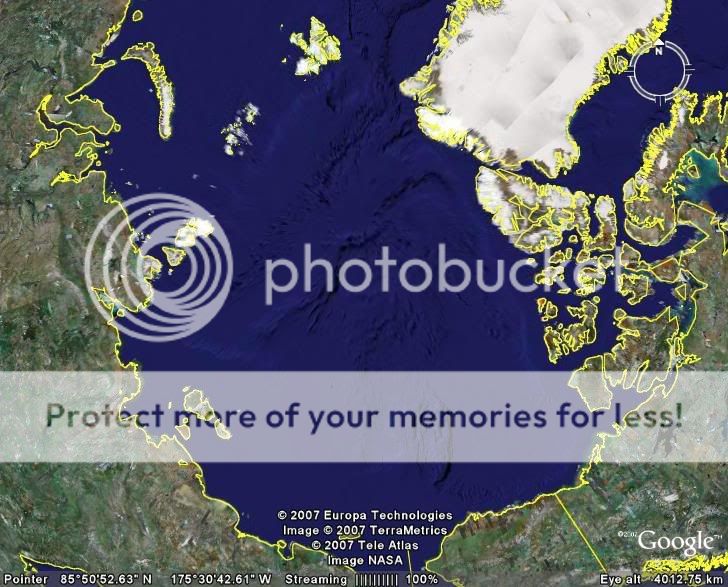
Obviously if you zoom in on the actual North Pole you see exactly as much detail as for every single other tract of ocean on Google Earth
Arctic regions will be poorer definition than other areas - probably due to the same conspiracy that makes Scotland appear under much poorer definition that England
It's an artifact of the mapping system.
However: it's something that could easily have been fixed. I'm not sure why Google Earth didn't want to take the effort to map out the poles, but there's no way for us to know what's out there without satellite imagery or going there ourselves.
However: it's something that could easily have been fixed. I'm not sure why Google Earth didn't want to take the effort to map out the poles, but there's no way for us to know what's out there without satellite imagery or going there ourselves.
I'm actually not replying to any particular post. I just feel like putting my 2 sense in. Basically the original questions have not been answered
even though some very good ideas have been rendered. The question remains because those thoughtful suggestions do not contain any real proof. All
open minded people should stay that way for now but continue to wonder why. I do. I for two would love to see some satellite shots of the poles. We
all should stay curious about why they have been blurred. I don't believe that it's Google's fault. I don't believe the images are available to
the general public for what ever reason. I don't believe it's because Google doesn't want to waste the bandwidth. I don't believe it's because
no one cares about the arctics. I would love an answer that included some images. All the shots available on the web are too zoomed out and or
easily doctored. Actually any image could be easily photoshopped these days but it still begs the question. Why not even some badly doctored images?
I hope this thread stays open until someone comes forward with real answers. I know, it's hard to trust anything these days. So much
disinformation. cheers, stinki
I'm with you, are there any images of the arctic/antarctic yet? (3 years later...)
And I don't want to see pictures of Scotland either!
And I don't want to see pictures of Scotland either!
Originally posted by Karlhungis
I am curious as well about why there are no satellite images of either pole. I have only been able to find one, and it wasn't even a direct shot. I heard somewhere that there is some sort of government regulation that won't allow the public release of satellite images of the poles. Who knows if that is true or not.
Here is one from 1968..allegedly. I've never been there so I'm not sure if it's an accurate depiction... yet here it is FWIW.
[atsimg]http://files.abovetopsecret.com/images/member/834c69c17d15.jpg[/atsimg]
The reason is simple, earth masses are done by plane and are therefore in high detail, the poles are done by satellite and low res compares to land
masses, so its blurry when you try to zoom in.
The same thing happens if you try to zoom in on some parts of land too.
The same thing happens if you try to zoom in on some parts of land too.
reply to post by ADVISOR
Those aren't real pics of earth, as a mod I expect better.
Clearly computer generated. I think all we are looking for are real pics of the north and south poles.
Those aren't real pics of earth, as a mod I expect better.
Clearly computer generated. I think all we are looking for are real pics of the north and south poles.
new topics
-
Where should Trump hold his next rally
2024 Elections: 1 hours ago -
Shocking Number of Voters are Open to Committing Election Fraud
US Political Madness: 2 hours ago -
Gov Kristi Noem Shot and Killed "Less Than Worthless Dog" and a 'Smelly Goat
2024 Elections: 3 hours ago -
Falkville Robot-Man
Aliens and UFOs: 3 hours ago -
James O’Keefe: I have evidence that exposes the CIA, and it’s on camera.
Whistle Blowers and Leaked Documents: 4 hours ago -
Australian PM says the quiet part out loud - "free speech is a threat to democratic dicourse"...?!
New World Order: 4 hours ago -
Ireland VS Globalists
Social Issues and Civil Unrest: 5 hours ago -
Biden "Happy To Debate Trump"
2024 Elections: 6 hours ago -
RAAF airbase in Roswell, New Mexico is on fire
Aliens and UFOs: 6 hours ago -
What is the white pill?
Philosophy and Metaphysics: 7 hours ago
top topics
-
A Warning to America: 25 Ways the US is Being Destroyed
New World Order: 15 hours ago, 21 flags -
Blast from the past: ATS Review Podcast, 2006: With All Three Amigos
Member PODcasts: 8 hours ago, 11 flags -
James O’Keefe: I have evidence that exposes the CIA, and it’s on camera.
Whistle Blowers and Leaked Documents: 4 hours ago, 10 flags -
Australian PM says the quiet part out loud - "free speech is a threat to democratic dicourse"...?!
New World Order: 4 hours ago, 10 flags -
Biden "Happy To Debate Trump"
2024 Elections: 6 hours ago, 10 flags -
Mike Pinder The Moody Blues R.I.P.
Music: 8 hours ago, 8 flags -
Ireland VS Globalists
Social Issues and Civil Unrest: 5 hours ago, 5 flags -
RAAF airbase in Roswell, New Mexico is on fire
Aliens and UFOs: 6 hours ago, 5 flags -
What is the white pill?
Philosophy and Metaphysics: 7 hours ago, 5 flags -
Putin, Russia and the Great Architects of the Universe
ATS Skunk Works: 11 hours ago, 4 flags
active topics
-
Shocking Number of Voters are Open to Committing Election Fraud
US Political Madness • 5 • : AwakeNotWoke -
President BIDEN's FBI Raided Donald Trump's Florida Home for OBAMA-NORTH KOREA Documents.
Political Conspiracies • 34 • : AwakeNotWoke -
The Acronym Game .. Pt.3
General Chit Chat • 7756 • : bally001 -
RAAF airbase in Roswell, New Mexico is on fire
Aliens and UFOs • 8 • : Skinnerbot -
Putin, Russia and the Great Architects of the Universe
ATS Skunk Works • 27 • : KnowItAllKnowNothin -
Falkville Robot-Man
Aliens and UFOs • 5 • : Ophiuchus1 -
Biden "Happy To Debate Trump"
2024 Elections • 42 • : JadedGhost -
Gold and silver prices....woo hoo
History • 86 • : lilzazz -
Mood Music Part VI
Music • 3110 • : TheDiscoKing -
University of Texas Instantly Shuts Down Anti Israel Protests
Education and Media • 308 • : cherokeetroy