It looks like you're using an Ad Blocker.
Please white-list or disable AboveTopSecret.com in your ad-blocking tool.
Thank you.
Some features of ATS will be disabled while you continue to use an ad-blocker.

Nellis range notam
page: 12
share:
Anyone have an idea about this notam? I know there were the two crashes last week but this is way north west.
Nellis Notam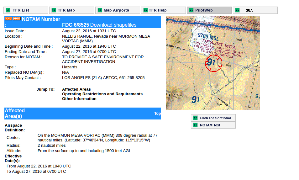
Nellis Notam
edit on 5331368201631America/ChicagoMon, 22
Aug 2016 20:53:36 -0500Mon, 22 Aug 2016 20:53:36 -050053 by nepatitan because: (no reason given)
a reply to: nepatitan
Helicopter crash?
www.fox5vegas.com...
More..
www.nbcnews.com...
"Four U.S. Air Force helicopter crew members hurt in a crash during an international combat training exercise in Nevada were part of a unit on assignment from Moody Air Force base in Georgia, officials said Friday."~nbc
Helicopter crash?
www.fox5vegas.com...
More..
www.nbcnews.com...
"Four U.S. Air Force helicopter crew members hurt in a crash during an international combat training exercise in Nevada were part of a unit on assignment from Moody Air Force base in Georgia, officials said Friday."~nbc
edit on 22-8-2016 by Bigburgh because: (no reason given)
Might have to do with the MH-60 crash last week. Probably recovering it. They didn't say where it went down other than the NTTR.
I though about the helicopter as well but thought I read it was close to the base?
This is the NOTAM I had right after the crash. This thread threw me off by the later date.
I've driven through Coal Valley. I suggest avoiding people in the area.
Tail on the crashed A-4 is N140EM.
LSV NELLIS AFBM0403/16 - AERODROME TEMPORARY FLIGHT RESTRICTIONS: WITHIN 5NM OF 374834N/1151315W UP TO 10,000FT MSL. 19 AUG 06:47 2016 UNTIL 26 AUG 23:59 2016. CREATED: 19 AUG 06:47 2016
I've driven through Coal Valley. I suggest avoiding people in the area.
Tail on the crashed A-4 is N140EM.
originally posted by: gariac
This is the NOTAM I had right after the crash. This thread threw me off by the later date.
LSV NELLIS AFBM0403/16 - AERODROME TEMPORARY FLIGHT RESTRICTIONS: WITHIN 5NM OF 374834N/1151315W UP TO 10,000FT MSL. 19 AUG 06:47 2016 UNTIL 26 AUG 23:59 2016. CREATED: 19 AUG 06:47 2016
I've driven through Coal Valley. I suggest avoiding people in the area.
Tail on the crashed A-4 is N140EM.
I am translating 374834N/1151315W to 37.4834°N, 115.1315°W
About 3.75 miles east of Ash Springs.
EDITED TO ADD:
Coordinates from OP are here:
37.809444°, -115.220833°
23 miles northish. Hmm.
edit on 23-8-2016 by FosterVS because: (no reason given)
originally posted by: tomra
originally posted by: gariac
I've driven through Coal Valley. I suggest avoiding people in the area.
Beeing curious, why should people of coal valley be avoided?
Here is a hint
Or a more contemporary clue
new topics
-
Flag Draped Fury
Political Issues: 18 minutes ago -
The BEAST System of Revelation has been awoken and has assumed control, at least since COVID.
New World Order: 1 hours ago -
The Department of Justice Spies on Congress with Google Assisting.
Political Conspiracies: 7 hours ago -
HOUSE VOTES 320-91 TO BAN CHRISTIAN BELIEFS IN AMERICA
Political Issues: 11 hours ago
top topics
-
Thousands of Anti-Semitic People Protest Israel's government in Tel Aviv
Middle East Issues: 14 hours ago, 12 flags -
Dugin's interview and the West's complete ignorance of Russia
New World Order: 14 hours ago, 10 flags -
HOUSE VOTES 320-91 TO BAN CHRISTIAN BELIEFS IN AMERICA
Political Issues: 11 hours ago, 9 flags -
The Department of Justice Spies on Congress with Google Assisting.
Political Conspiracies: 7 hours ago, 8 flags -
The BEAST System of Revelation has been awoken and has assumed control, at least since COVID.
New World Order: 1 hours ago, 1 flags -
Flag Draped Fury
Political Issues: 18 minutes ago, 0 flags
active topics
-
UN Estimates Rebuilding Gaza Will Cost Up To 40 Billion Dollars
Middle East Issues • 137 • : CarlLaFong -
V.P. Biden's Cure Cancer Project Was Successful - President Biden Says Cancer is Now Eradicated.
Medical Issues & Conspiracies • 30 • : Croton -
Gov Kristi Noem Shot and Killed "Less Than Worthless Dog" and a 'Smelly Goat
2024 Elections • 169 • : KrustyKrab -
HOUSE VOTES 320-91 TO BAN CHRISTIAN BELIEFS IN AMERICA
Political Issues • 57 • : GENERAL EYES -
Israel rejected early Hamas offer to free all civilians if IDF didn’t enter Gaza
Middle East Issues • 185 • : Xtrozero -
Flag Draped Fury
Political Issues • 0 • : BigRedChew -
The Dark Pyramid of Alaska and the Why Files take on the subject
Whistle Blowers and Leaked Documents • 15 • : anthelion -
US drug control agency will move to reclassify marijuana in a historic shift, AP sources say
Breaking Alternative News • 77 • : confuzedcitizen -
Motive for the alleged assault on Blasey Ford. Conservatives should see this.
General Conspiracies • 26 • : Zanti Misfit -
Farmers jailed without due process
General Conspiracies • 26 • : grey580
2