It looks like you're using an Ad Blocker.
Please white-list or disable AboveTopSecret.com in your ad-blocking tool.
Thank you.
Some features of ATS will be disabled while you continue to use an ad-blocker.

Pilot makes emergency landing on highway, then later notices nearby AFB that isn't on the map (AKA
page: 17
share:
This is a report from NASA's ASRS (Aviation Safety Reporting System).
For a more English explanation of the event, the pilot encountered bad weather and decided to land on Nevada route 6. There is a discrepancy in the exact location the pilot landed. One part of the report indicates SM (statute miles), while the other indicates NM (nautical miles). Where the report gets entertaining is the pilot discovers a 7000ft runway near where the emergency landing was made, listed in the report as N38 20 00 W 116 16 00. This is the location of the USAF (and others) airstrip known as Base Camp.
Base Camp
On the FAA sectional map, Base Camp is indicated as abandoned, and even if the pilot saw the runway, it has Xs on it indicating it is not safe to land there.
Incidentally, there is brand new imagery in the area of Base Camp on Google Earth. The date is 5/3/2014.
Look for ACN 337010
Time / Day
Date : 199605
Local Time Of Day : 1201-1800
Place
Locale Reference.Airport : TPH
State Reference : NV
Relative Position.Distance.Nautical Miles : 79
Altitude.AGL.Single Value : 0
Aircraft
Aircraft Operator : Personal
Make Model Name : PA-32 Cherokee Six/Lance/Saratoga/6X
Crew Size.Number Of Crew : 1
Narrative: 1 I WAS FLYING MY PA32-300 (CHEROKEE 6) FROM CNY TO MY HOME BASE, TRK VIA SALINA, UT, THENCE TO MLF AND MVA. ABOUT HALFWAY BTWN MLF AND MVA I ENCOUNTERED INCREASING TURB AND RAPIDLY DETERIORATING VISIBILITY. I DECIDED TO CHANGE COURSE TO THE NEAREST ARPT, TPH. I RADIOED FOR CONDITIONS AND WAS TOLD TPH WAS IFR (I AM PRESENTLY VFR ONLY). MY SIT WAS THAT ALL QUADRANTS WERE NOW IFR. I DECIDED TO PUT DOWN WHERE I WAS AND MADE AN OFF FIELD LNDG 79 SM E OF TPH ON US 6. I LNDED SAFELY AND REMAINED OVERNIGHT IN TPH. I RETURNED NEXT DAY, TOOK OFF AND CONTINUED ON TO TRK. INCIDENTLY, THERE IS A CLOSED FIELD JUST W OF WHERE I PUT DOWN THAT I AM NOW TOLD AND SAW IS JUST 10 NM FROM MY POS THAT HAS A BRAND NEW 7000 FT RWY BELONG TO THE AIR FORCE. HAD IT SHOWN ON THE CHART AS A REAL ARPT, I WOULD NOT HAVE BEEN IN THE DANGER THAT I WAS. SEE LAS VEGAS SECTIONAL N38:20:00 W116:16. I WAS ADVISED THAT VFR WAS NOT RECOMMENDED FOR W NV AND THE SIERRA DUE TO OBSCURATION, TURB, ETC. HOWEVER, MY (VERY) LIMITED EXPERIENCE WITH FLT SVC IS THAT THEY ALMOST ALWAYS SAY 'VFR NOT RECOMMENDED.' I TRIED TO PUSH IT. I GOT LUCKY, GOD SMILED, KISSED ME AND MADE IT GOOD.
They'd rather see a pilot with a possible emergency land on a g.d. highway, than direct him to the obviously NOT "closed field" at Base Camp.
originally posted by: FosterVS
They'd rather see a pilot with a possible emergency land on a g.d. highway, than direct him to the obviously NOT "closed field" at Base Camp.
One civilian lost to keep a secret, secret? yeah can live with that.
WW1, WW2, Korea, Vietnam, Persian 1 and 2, Libya, Afghanistan... plenty of folks died to keep secrets.
As an aside, awesome find Gariac.
Small shack added at 38°18'36.83"N 116°16'42.38"W.
Maybe the old HF antenna is removed at 38°18'34.33"N 116°16'44.04"W
The new imagery covers the Warm Springs repeater site, but I don't see any changes there. The T-Mobile coverage map shows reception near Warm Springs on a roaming partner. AT&T shows coverage there as well.
Maybe the old HF antenna is removed at 38°18'34.33"N 116°16'44.04"W
The new imagery covers the Warm Springs repeater site, but I don't see any changes there. The T-Mobile coverage map shows reception near Warm Springs on a roaming partner. AT&T shows coverage there as well.
a reply to: Astr0
I decided to do a yahoo search on the Tonopah Test range (yeah, what came over me), and discovered a website called FactualWorld.
FactualWorld
That is where I found the ASRS website. Search engines can't see into such databases since they have no way to drive the search.
If you can figure out the search engine, set the location for various airports surrounding the NTTR. Once the location is set, just hit search. You don't need any more search terms. The search engine will pick up everything related to that location. You need to enter the three letter codes, i.e. INS for Indian Springs, TPH for Tonopah Civilian. I haven't found the report of the cargo plane landing at the TTR yet.
Regarding keeping Base Camp a secret, it is right by the highway. Now route 6 isn't like the 405, i.e. not a whole lot of people drive past it. But it wouldn't surprise me if ten thousand people know of the base. It is such a poorly kept secret that it would make more sense just to put it on the map. Commercial jet fly over it all the time.
Me and a pilot friend have made a number of landing at a old military emergency airfield that is Xed out of service.
Cuddeback, 35.281501, -117.401276
It was closed so long ago that the Xs are not even showing now.
by the way we drove out and walked it before the first time we landed there.
its a great place to airplane camp.
Cuddeback, 35.281501, -117.401276
It was closed so long ago that the Xs are not even showing now.
by the way we drove out and walked it before the first time we landed there.
its a great place to airplane camp.
So an emergency landing is allowed to land then how many afterwards will falsely claim emergency and land breaching security, it would sends a message
to anyone curious with a plane or worst a terrorist plot/attack
a reply to: TritonTaranis
If it is just a strip how much damage is a terrorist going to do? And so what if a curious plane lands there. It is their neck. Oh, I suppose the days of landing in a hay field are long gone?
If it is just a strip how much damage is a terrorist going to do? And so what if a curious plane lands there. It is their neck. Oh, I suppose the days of landing in a hay field are long gone?
originally posted by: gariac
a reply to: Astr0
g keeping Base Camp a secret, it is right by the highway. Now route 6 isn't like the 405, i.e. not a whole lot of people drive past it. But it wouldn't surprise me if ten thousand people know of the base. It is such a poorly kept secret that it would make more sense just to put it on the map. Commercial jet fly over it all the time.
Like gariac says, it's right on the g.d. highway. Anything that happens there, or lands there, can be seen from the highway. Second to last time I was there, and stopped to take pictures, someone came zooming over from the "base" to ask me "are you OK, can I help you?". Yes. and no. They used to have a "no stopping" sign there I believe, but now nothing like that, other than the sign when you actually enter/pass through "the base". There is a tourist turnout right there anyways.
edit on 6-7-2014 by FosterVS because: (no reason given)
I was speaking not from my perspective, but answering 'would a government let one person die to keep a secret'.
The answer is a resounding YES. History proves this in spades and then some.
The answer is a resounding YES. History proves this in spades and then some.
a reply to: FosterVS
I vaguely remember what the tourist sign says, but I believe it is related to the mine on Tybo Road.
Seriously, how secure is a base where a public road runs through it. Last time I checked, the no stopping signs were there on Tybo Road, but I don't know if they are enforceable. In rural areas, people put up signs all the time that have no legal authority. The only time the law bothers to get involved if when they block roads. Ranchers have been known to put up illegal gates. There are many Cliven Bundy types in the desert that think grazing rights mean ownership.
BTW, if you use Google Earth on the Tybo mine, you can see pickup trucks parked there. I believe you can drive through Tybo Mine, but going on mine property is trespassing.
originally posted by: gariac
a reply to: FosterVS
I vaguely remember what the tourist sign says, but I believe it is related to the mine on Tybo Road.
Yup, it's one of those turnouts with a "monument" with a sign on it. I am almost 100% it's about Tybo, or Tybo Hot Creek. Although, I had my eyes and lens pointed at Base Camp.
Seriously, how secure is a base where a public road runs through it. Last time I checked, the no stopping signs were there on Tybo Road, but I don't know if they are enforceable.
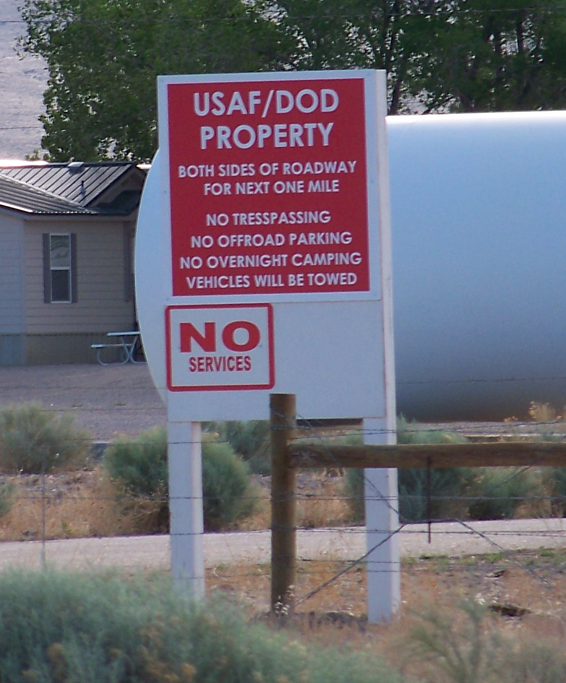
"Tresspassing"? (sic) Was that an in-house sign? Wow. Notice it states DOD, not just USAF.
In theory, someone could park on the road (no offroad parking) and stay for an extended period (no overnight camping). They would probably come and tell you to quit blocking the road...
BTW, if you use Google Earth on the Tybo mine, you can see pickup trucks parked there. I believe you can drive through Tybo Mine, but going on mine property is trespassing.
Driving through Base Camp, and to the Tybo mine(s) was on my bucket list in April. I must have been too intent on TTR and forgot about it.
EDITED TO ADD: for anyone interested, there is a "camping/picnic" spot < 5 miles down the road, NE. Would make an excellent observation point for some longer term than just a drive-by.
edit on 7-7-2014 by FosterVS because: (no reason given)
edit on 7-7-2014 by FosterVS because:
(no reason given)
a reply to: FosterVS
The land was AEC owned originally, so maybe that is the deal with the DOE on the sign. The VOR is AEC based on the Morse code.
I've camped out at the lunar crater area a bit further down the road. If you want a better maintained road, the lava outcrop east of Base Camp and just west of the Lunar Crater would do.
The area near Project Faultless is intended to be a camp ground. Look up Moores Station. The house is private, but prior to the house, it is BLM.
By the time you are east of Base Camp, the sky is really dark.
edit on 7-7-2014 by gariac because: (no reason given)
Military and National Guard bases along with other protected government buildings, do not show up on GPS. It drops you about half a mile away.
originally posted by: gariac
a reply to: FosterVS
The land was AEC owned originally, so maybe that is the deal with the DOE on the sign. The VOR is AEC based on the Morse code.
You missed it - DoD, not DOE. I think we talked about the history of this place once, being a landing strip for the AEC for the Operation Plowshare project.
Might explain some of the strange aircraft seen there, i.e. CIA owned?
a reply to: FosterVS
I didn't miss it, I misread it. ;-) Base Camp was the staging area for Project Faultless just to the east. The AEC had Halligan Mesa as well, though they called it No Name Hill on their documents.
While the DOE is no longer at Base Camp or Halligan Mesa, they do have some gear at the Warm Springs repeater site.
I'm not sure why they bothered to put DoD on the sign. Incidentally, the DoD style guide is to make the "o" lower case, so two demerits for the sign maker. One for the spelling error, and two for using DOD.
There is zero doubt the CIA uses Base Camp, simply based on the civilian aircraft seen there that have been clearly implicated in CIA operations. The Cessna Caravan holding company (One Leasing) got involved in the Plan Columbia fiasco where the contractors were held hostage by the FARC. [In theory, no money exchanged hands for their freedom. Uh, right.] Then the CN235s were caught up in the Extraordinary Rendition operation investigation, though I doubt any prisoners were transported on them. Rather infiltration teams used the CN235 for whatever the CIA was doing.
There is a Plan Mexico underway, though the official name is Merida Initiative, so as to not be associated with the Plan Mexico fiasco. This started at the end of the Bush II administration and was never stopped by President Obama. The programs have a mind of their own.
I like this one. I guess if you want to overfly TTR/TNX, mid-morning on a Saturday is the best time:
ENRTE TO CEDAR CITY, UT. ONCE OVER SIERRA NEVADA MTN RANGE DSNDED TO 11500'. PREFLT MAP CHK INDICATED FLT FROM SFO VIA BUCHANAN DIRECT TO CEDAR CITY WOULD BYPASS RESTR AREA TO THE N. OVER BUCHANAN SET LORAN AND PROCEEDED ON COURSE. I NAVIGATED UNTIL OVER MON LAKE (CA). I THEN ASKED MY WIFE (STUDENT PLT) TO WATCH ALT, COURSE, AND TFC WHILE I PREPARED A SPEECH FOR S UT UNIVERSITY COMMISSIONING OF ROTC CADETS TO SECOND LT. I GLANCED UP FROM TIME TO TIME AND WE SEEMED TO BE ON COURSE AND AT PROPER ALT. I HAD THE AUTOPLT ENGAGED. MY WIFE INQUIRED ABOUT AN AIRFIELD ALMOST DIRECTLY BELOW US. I CHKED THE CHART AND IDENTED THE FIELD AS BEING JUST INSIDE THE N EDGE OF THE TONOPAH RESTR AREA. I ALWAYS FLY WITH RADIO #1 ON 122.0 FLT WATCH AND RADIO #2 ON 121.5 EMER. DURING FLTS NEAR CHINA LAKE, I'VE HAD GND CONTACT ME ON 121.5 TO INSURE WE STAYED CLR OF THE RESTR AREA. NO ONE COMMUNICATED ON 122.0 OR 121.5 AS WE FLEW OVER THE FIELD AT TONOPAH. I CONTINUED ON, MADE A PIREP TO CEDAR CITY FSS ON 122.2 CONCERNING WX AND WIND OVER THE SIERRA NEVADAS, NOTHING WAS SAID BY THEM ABOUT ANY VIOLATION. I DIDN'T NOTICE ANY ACTIVITY ON OR NEAR THE TONOPAH AIRFIELD, NOR DID I SEE ANY AIR ACTIVITY. IT WAS SATURDAY MID-MORNING. I NOTICED THAT MY DG HAD MOVED ALMOST 20 DEGS OFF COURSE TOWARDS THE S. THIS HAD CAUSED THE AUTOPLT TO GRADUALLY STEER THE ACFT R OF OUR INTENDED COURSE. I RESET THE DG WITH THE MAG COMPASS AND CORRECTED OUR COURSE FOR CEDAR CITY. THERE IS NO QUESTION THAT MY ATTN TO FLYING WOULD HAVE PREVENTED THIS POSSIBLE INTRUSION INTO RESTR AIRSPACE. THE WEEKEND, PLUS PRESSURE OF PUBLIC SPEAKING ENGAGEMENTS PRIOR TO OUR FLT HAD MY MIND ON PREPARING FOR THE ROTC COMMISSIONINGS AT CEDAR CITY. MY WIFE HAD MANY HRS IN THE R SEAT BOTH VMC AND IMC, BUT SHE DIDN'T NOTICE THE INCREASING IRREGULARITY BTWN THE DG (AUTOPLT) AND MAG COMPASS. THERE WERE NO NEAR MISSES, NO ATTEMPTED COMS FROM GND TO AIR. NO ONE HAS SAID ANYTHING, BUT I BELIEVE WE FLEW INTO RESTR AIRSPACE.
edit on 10-7-2014 by FosterVS because: (no reason
given)
edit on 10-7-2014 by FosterVS because: (no reason given)
a reply to: FosterVS
You can fly over the TTR on weekends, but you do need to contact Nellis Control. Often the USAF reserve trains in the airspace on the weekend. You can even further south if the range isn't in use. Of course, again with Nellis Control approval.
From Tom Mahood's Bluefire website:
NTTR flight
Info on the flight
And a teaser paragraph from the page:
Exactly what we had planned was a traverse of R-4807A, the restricted airspace south of the Tonopah Test Range and north of the NTS and Groom airspace. This was the airspace that opened up in July of 1995, allowing civilian air traffic on Sundays when the military had no Flag exercises planned. This certainly demanded a look. Will had taken the precaution of checking with the local FAA Flight Service Station before we left, to ensure there wouldn’t be any surprises. Hah!
new topics
-
Putin, Russia and the Great Architects of the Universe
ATS Skunk Works: 1 hours ago -
A Warning to America: 25 Ways the US is Being Destroyed
New World Order: 6 hours ago -
President BIDEN's FBI Raided Donald Trump's Florida Home for OBAMA-NORTH KOREA Documents.
Political Conspiracies: 11 hours ago
top topics
-
President BIDEN's FBI Raided Donald Trump's Florida Home for OBAMA-NORTH KOREA Documents.
Political Conspiracies: 11 hours ago, 29 flags -
A Warning to America: 25 Ways the US is Being Destroyed
New World Order: 6 hours ago, 12 flags -
Las Vegas UFO Spotting Teen Traumatized by Demon Creature in Backyard
Aliens and UFOs: 17 hours ago, 7 flags -
2024 Pigeon Forge Rod Run - On the Strip (Video made for you)
Automotive Discussion: 17 hours ago, 4 flags -
Is AI Better Than the Hollywood Elite?
Movies: 13 hours ago, 3 flags -
Maestro Benedetto
Literature: 13 hours ago, 1 flags -
Putin, Russia and the Great Architects of the Universe
ATS Skunk Works: 1 hours ago, 1 flags
active topics
-
Is AI Better Than the Hollywood Elite?
Movies • 19 • : GENERAL EYES -
University of Texas Instantly Shuts Down Anti Israel Protests
Education and Media • 271 • : CriticalStinker -
A Warning to America: 25 Ways the US is Being Destroyed
New World Order • 12 • : ColeYounger2 -
Weinstein's conviction overturned
Mainstream News • 27 • : brodby -
Gaza Terrorists Attack US Humanitarian Pier During Construction
Middle East Issues • 38 • : brodby -
ChatGPT Beatles songs about covid and masks
Science & Technology • 24 • : iaylyan -
The Acronym Game .. Pt.3
General Chit Chat • 7754 • : bally001 -
Nearly 70% Of Americans Want Talks To End War In Ukraine
Political Issues • 96 • : andy06shake -
Rupert Murdoch engaged at 92
People • 8 • : brodby -
"We're All Hamas" Heard at Columbia University Protests
Social Issues and Civil Unrest • 287 • : FlyersFan
7