It looks like you're using an Ad Blocker.
Please white-list or disable AboveTopSecret.com in your ad-blocking tool.
Thank you.
Some features of ATS will be disabled while you continue to use an ad-blocker.

Does anyone know what is happening off the coast of California with the weather?
page: 15
share:
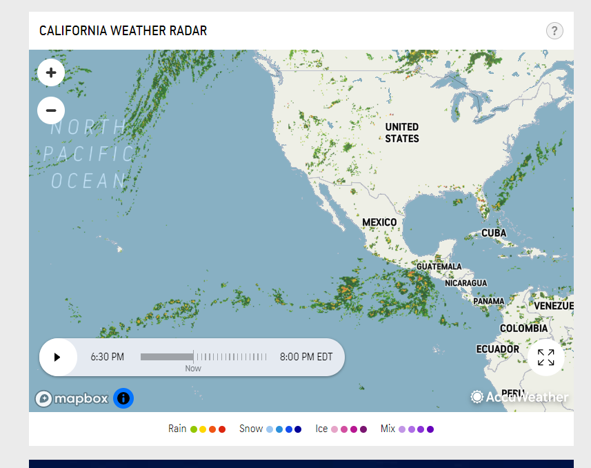
I had a friend of mine contact me and he has been stuck on watching the weather off the coast of California and told me that for the past month everyday anytime of day the radar for California looks like the screen shot I have included. I started watching it and , sure enough, for the last 2 days I have been watching, everyday it looks like this. It is like at Hawaii it divides and goes to Canadian coast and Mexican coast. Is it a radar anomaly, is it due to the jet stream steering the weather in those directions, is it the topography of Hawaii causing it, It is not pressure systems as they change daily and there has been both high and low pressure systems but the weather pattern is always the same.
To go down a fun rabbit hole I was thinking off the California coast is where a lot of the UAP sightings by the Navy have been.
Please feel free to chime in and help me figure this out it is really intriguing me and ATS peeps always seem to come up with the answer or a really good explanation, or fun theories.
edit on 23-6-2021 by ydobon because: (no reason given)
originally posted by: ydobon
I had a friend of mine contact me and he has been stuck on watching the weather off the coast of California and told me that for the past month everyday anytime of day the radar for California looks like the screen shot I have included. I started watching it and , sure enough, for the last 2 days I have been watching, everyday it looks like this. It is like at Hawaii it divides and goes to Canadian coast and Mexican coast. Is it a radar anomaly, is it due to the jet stream steering the weather in those directions, is it the topography of Hawaii causing it, It is not pressure systems as they change daily and there has been both high and low pressure systems but the weather pattern is always the same.
To go down a fun rabbit hole I was thinking off the California coast is where a lot of the UAP sightings by the Navy have been.
Please feel free to chime in and help me figure this out it is really intriguing me and ATS peeps always seem to come up with the answer or a really good explanation, or fun theories.
Pretty sure it’s a manifestation of Hadley Cell circulation:
en.wikipedia.org...
Here’s another online application I use for understanding my local weather in Northern California:
earth.nullschool.net.../wind/surface/level/orthographic=-148.39,53.45,432
It shows the real time surface wind patterns anywhere on Earth.
a reply to: 1947boomer
Everyday? for weeks on end? At any time of the day? I am not disagreeing with what you are presenting but it seems odd
Everyday? for weeks on end? At any time of the day? I am not disagreeing with what you are presenting but it seems odd
Yes. Hadley Cells are extremely stable, especially when over large bodies of water, and the North Pacific Ocean is the largest uninterrupted body of
water on the planet. Another name for Hadley Cell circulation is “trade winds”. The Spanish used the trade winds to support trade between
Acapulco and Manilla for 150 years using Spanish galleons, which were only able to sail downwind. That means that they had to find a band of wind
blowing from East to West and another band blowing West to East, which they did. They were able to capitalize on that pattern (literally) for that
period of time because the pattern was so stable.
The Hadley Cell circulation pattern will shift South to North and back with the seasons, however. Right now, we are basically at the Summer Solstice, which means the Sun is at its Northern most position. That means the Hadley Cell circulation is also near its Northern most position.
This North-South migration of the pattern is actually why California has a Mediterranean climate.
edit on 23-6-2021 by 1947boomer because:
ETA
The storms are probably building along a fault line that has lots of energy in it. I have seen that kind of stuff before a quake or eruption in
articles from the governments earthquake and volcano scientists. The thing is they cannot really interpret if it is going to slip or erupt most
times. It seems just to be a quirk of nature. They were able to say it does give an increased risk of a quake, that was about all they could say
till they get more evidence so they can determine a pattern. That was about five years ago, they may have more on that by now if a person was to
research it.
new topics
-
Maestro Benedetto
Literature: 1 hours ago -
Is AI Better Than the Hollywood Elite?
Movies: 1 hours ago -
Las Vegas UFO Spotting Teen Traumatized by Demon Creature in Backyard
Aliens and UFOs: 5 hours ago -
2024 Pigeon Forge Rod Run - On the Strip (Video made for you)
Automotive Discussion: 5 hours ago -
Gaza Terrorists Attack US Humanitarian Pier During Construction
Middle East Issues: 6 hours ago -
The functionality of boldening and italics is clunky and no post char limit warning?
ATS Freshman's Forum: 7 hours ago -
Meadows, Giuliani Among 11 Indicted in Arizona in Latest 2020 Election Subversion Case
Mainstream News: 8 hours ago -
Massachusetts Drag Queen Leads Young Kids in Free Palestine Chant
Social Issues and Civil Unrest: 8 hours ago -
Weinstein's conviction overturned
Mainstream News: 9 hours ago -
Supreme Court Oral Arguments 4.25.2024 - Are PRESIDENTS IMMUNE From Later Being Prosecuted.
Above Politics: 11 hours ago
top topics
-
Krystalnacht on today's most elite Universities?
Social Issues and Civil Unrest: 11 hours ago, 9 flags -
Supreme Court Oral Arguments 4.25.2024 - Are PRESIDENTS IMMUNE From Later Being Prosecuted.
Above Politics: 11 hours ago, 8 flags -
University of Texas Instantly Shuts Down Anti Israel Protests
Education and Media: 13 hours ago, 7 flags -
Weinstein's conviction overturned
Mainstream News: 9 hours ago, 7 flags -
Gaza Terrorists Attack US Humanitarian Pier During Construction
Middle East Issues: 6 hours ago, 7 flags -
Massachusetts Drag Queen Leads Young Kids in Free Palestine Chant
Social Issues and Civil Unrest: 8 hours ago, 6 flags -
Meadows, Giuliani Among 11 Indicted in Arizona in Latest 2020 Election Subversion Case
Mainstream News: 8 hours ago, 5 flags -
Las Vegas UFO Spotting Teen Traumatized by Demon Creature in Backyard
Aliens and UFOs: 5 hours ago, 4 flags -
2024 Pigeon Forge Rod Run - On the Strip (Video made for you)
Automotive Discussion: 5 hours ago, 2 flags -
Any one suspicious of fever promotions events, major investor Goldman Sachs card only.
The Gray Area: 16 hours ago, 2 flags
5