It looks like you're using an Ad Blocker.
Please white-list or disable AboveTopSecret.com in your ad-blocking tool.
Thank you.
Some features of ATS will be disabled while you continue to use an ad-blocker.

Janet Jockey Off Course?
page: 12
share:
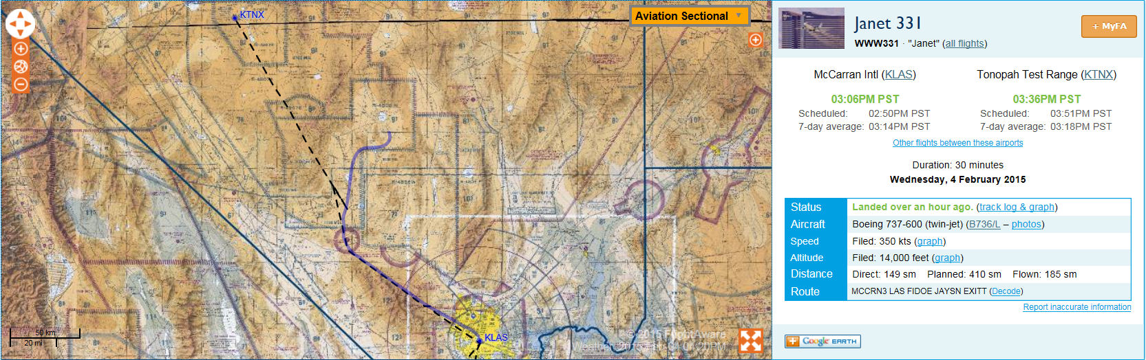
gariac will probably jump in a correct me if I am wrong on this - I believe the dotted-line is the intended or filed flight plan, and the solid purple
line is actual flight path? I notice there is a waypoint called "EXITT" that the logged flight path usually ends on these flights, right where the
plane either enters or exits the range. I take it the pilot or copilot forgot to switch something off?
Bigger pic:
files.abovetopsecret.com...
Here is Flightaware link:
flightaware.com...
Bigger pic:
files.abovetopsecret.com...
Here is Flightaware link:
flightaware.com...
edit on 4-2-2015 by FosterVS because: (no reason given)
What happened is both the Tonopah Test Range and Groom Lake use KTNX for their location. That is why the dotted line starts at the TTR. That is,
flightaware thinks the route starts at the TTR. However, the tracking shows the actual route.
This is probably an error with the FAA "filter" rather than what the pilot files.
Groom flights generally are at 14kft or 15kft, depending on direction.
This is probably an error with the FAA "filter" rather than what the pilot files.
Groom flights generally are at 14kft or 15kft, depending on direction.
new topics
-
One More Night at the Pig and Blanket (Time 2024)
Short Stories: 22 minutes ago -
Expert Says Parents Should Ask Babies Permission to Change Nappies.
General Chit Chat: 1 hours ago -
Hard evidence of a Royal plot on the US....if only i had proof.
ATS Skunk Works: 2 hours ago -
Do you name your cars ?
General Chit Chat: 3 hours ago -
Jim Biden Was in Business with Qatari Officials
US Political Madness: 5 hours ago -
I may have had a talk with Pope Francis about his plans for our nation
The Gray Area: 6 hours ago -
Sleep paralysis and the implantation of some weird Matrix-esque demon creature...
The Gray Area: 7 hours ago -
Say his name
US Political Madness: 7 hours ago -
There is no such thing as moonlight.
General Chit Chat: 8 hours ago -
5 probed after 18-year old girl dies as a result of having the COVID jab
Diseases and Pandemics: 9 hours ago
2