It looks like you're using an Ad Blocker.
Please white-list or disable AboveTopSecret.com in your ad-blocking tool.
Thank you.
Some features of ATS will be disabled while you continue to use an ad-blocker.

Bohol islands sinking amid aftershocks
page: 1share:
MANILA, Philippines -- Some small islands off the coast of Bohol are sinking amid aftershocks following the 7.2 magnitude earthquake that hit the province last October 15, residents said.
Isla Batasan is one of the islands located between Bohol and Cebu. It is experiencing sudden floods, causing its residents to believe that their island is slowly sinking.
"Iba ngayon. Dati nung lumindol hindi nakakapasok yung tubig dagat pero kagabi, hanggang tuhod yung tubig," said Dindo Carmona, a barangay councilor.
The flood also left watermarks on some of the buildings on the island.
Some residents decided to stay on their boats after their houses were submerged in water after the earthquake.
Source: ABS-CBNnews.com
First let me place the Bohol earthquake in the world for those who don't know.
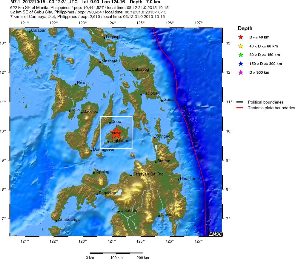
Click the image to enlarge
I don't know if anyone is aware of the predicted earthquake in the Philippines by the International Earthquake and Volcano Prediction Center. My post on my blog about this gives some more details. The predicted earthquake is located some distance away, but not so far away as to be out of the question as identified with the prediction.
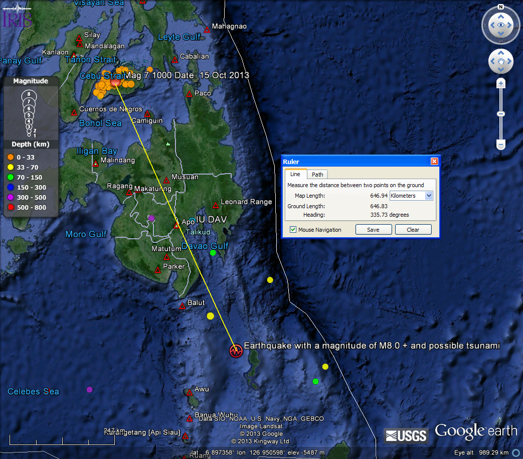
Click the image to enlarge
In the OP article it as also stated
Director Renato Solidum of the Philippine Institute of Volcanology and Seismology (Phivolcs) explain that there is indeed a big possibility that some islands may start sinking after the earthquake, due to liquefaction and earthquake deformation.
Liquefaction in this instance I am not so sure about, but deformation yes indeed.
The smaller quakes take some time to arrive in catalogues however the IRIS Earthquake Browser shows a cluster of 49 aftershocks so far. Here is the list and here the map view.
In the bottom left hand corner of the map view is the coolest bit of new software for earthquakes, the 3D Viewer. Go have a play with it. (Suggestion: Look north > drag the view slightly to give a tilt > Rotate > Side To Side. (Please note the the jerky motion in the video is NOT the viewer but the software I used to capture the clip)
The question really is, was the Magnitude 7.1 that has caused the islands to start sinking, the foreshock to a larger earthquake in the area?
First we are coming up to around 40 days from the inter quake period current for Magnitude 8 quakes which averages at 187 days You can see details of this in the Geophysical report linked in my signature (the 18th is about to issue)
In particular I would draw your attention in that report to the rolling 52 week total of calculated mag 5 quakes (explanation in the report) and the average TJ of energy per Mag 5. The number has been steadily falling and the average energy of each quake has been steadily rising. This is the graph for the report about to be published
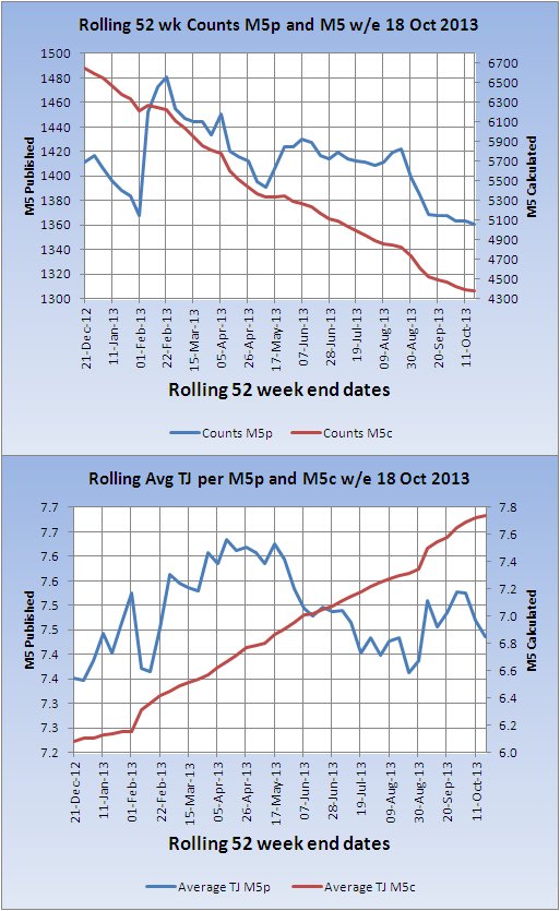
The data for that is drawn from USGS, however an analysis of ANSS data to 30 September 2013, whilst still showing that trend, does not show as steep a decline/rise. Despite that, the period of this trend is not only unusually long but seems to be pretty much unique in it's length over the past 11 years.
I am not in a position to publish the result of my analysis yet. It has been months already and I have only completed the global part. I have many months of work to analyse each seismic region to see which is contributing to this. What I can say at this point is that the change in dynamics appears to have occurred immediately after the Mag 8.1 in the Santa Cruz region.
I believe it is possible the Bohol Mag 7.2 was a foreshock, however if that is the case the main shock is very unlikely to be in Bohol as the Mag 7.2 was the strongest in the area since 1970 according to IRIS.
Here is the list of all 799 quakes since 1970
The problem arises that even in the area of the location for the Mag 8 prediction the maximum earthquake since 1970 has been a mag 7.2 (2002-03-05)
List of top 100 quakes since 1970
Maybe, one sincerely hopes, it won't happen and this was it.
By the way the link to the 'home' page of the IRIS Earthquake browser is in my signature.
If you are interested in getting accurate 'boxes' in the IEB see here: IRIS Earthquake Browser URL Builder
There is a link to the program download at the top of that page. Unfortunately only for Windows XP and upwards with .NET 4
If you are interested in getting accurate 'boxes' in the IEB see here: IRIS Earthquake Browser URL Builder
There is a link to the program download at the top of that page. Unfortunately only for Windows XP and upwards with .NET 4
So if I've understood you correctly, what you are saying is that these islands are indeed sinking as we speak, and if a larger magnitude eq does
occur as predicted by the statistical analysis, it could very well be goodnight to the poor people of these islands?
Rainbows
Jane
Rainbows
Jane
reply to post by angelchemuel
I reckon that is about the size of it Rainbows OG
Haven't seen you around on QW much recently.
I reckon that is about the size of it Rainbows OG
Haven't seen you around on QW much recently.
reply to post by PuterMan
I'm still lurking don't you worry! Think my last post was for your b'day
Rainbows
Jane
I'm still lurking don't you worry! Think my last post was for your b'day
Rainbows
Jane
Hey, QUAKE RIDING, QUAKE SURFER PUTERMAN . . .
What's your take on that rising red line in your 2nd graph?
Isn't that a significant change over the last what . . . 50+ years?
What exactly . . . as exactly as you can guesstimate . . . LOL . . . does that signify to YOU?
What are the implications? What do you think it shows, really?
What do folks need to realize it does NOT indicate, per se in terms of how they might misconstrue it. I realize the latter might be a grope to comment on.
THX THX for all you do.
PuterMan
The data for that is drawn from USGS, however an analysis of ANSS data to 30 September 2013, whilst still showing that trend, does not show as steep a decline/rise. Despite that, the period of this trend is not only unusually long but seems to be pretty much unique in it's length over the past 11 years.
I am not in a position to publish the result of my analysis yet. It has been months already and I have only completed the global part. I have many months of work to analyse each seismic region to see which is contributing to this. What I can say at this point is that the change in dynamics appears to have occurred immediately after the Mag 8.1 in the Santa Cruz region.
I believe it is possible the Bohol Mag 7.2 was a foreshock, however if that is the case the main shock is very unlikely to be in Bohol as the Mag 7.2 was the strongest in the area since 1970 according to IRIS.
Here is the list of all 799 quakes since 1970
The problem arises that even in the area of the location for the Mag 8 prediction the maximum earthquake since 1970 has been a mag 7.2 (2002-03-05)
List of top 100 quakes since 1970
Maybe, one sincerely hopes, it won't happen and this was it.
reply to post by abacus10
Here you go...fixed it!
I love Thunderbirds to this day, and I don't mind admitting I still have a huge crush on Virgil!
Although in this case I can't help but think that W.A.S.P would be of more help to the islanders
Now, back OT
Rainbows
Jane
Here you go...fixed it!
I love Thunderbirds to this day, and I don't mind admitting I still have a huge crush on Virgil!
Although in this case I can't help but think that W.A.S.P would be of more help to the islanders
Now, back OT
Rainbows
Jane
reply to post by PuterMan
"coolest bit of new software for earthquakes, the 3D Viewer. "
5 out of 4 STARS nice.
"coolest bit of new software for earthquakes, the 3D Viewer. "
5 out of 4 STARS nice.
Oh no!!! My people are sinking!!! Very avon garde Atlantian of them.... Not joking I am half part Philipino~
/end sarcasm~joke
I hope that everyone get's off that island and fast!
/end sarcasm~joke
I hope that everyone get's off that island and fast!
Update 23.10.2013 13:20 UTC:
Bad news once again with now 209 presumed dead. The other numbers remain the same.
The infrastructure cost has risen to 1.426 billion PHP counted (approx. 35 million USD)
earthquake-report.com...
Rainbows
Jane
reply to post by BO XIAN
As I said BO something has changed. At least in the last 11 years this pattern has not been seen over this length of time. It is way too long winded to explain here and I am not finished with it - mainly because I need to identify if one area is causing this and that means months of work. Don't worry i will let you know when I get an answer.
What's your take on that rising red line in your 2nd graph?
As I said BO something has changed. At least in the last 11 years this pattern has not been seen over this length of time. It is way too long winded to explain here and I am not finished with it - mainly because I need to identify if one area is causing this and that means months of work. Don't worry i will let you know when I get an answer.
edit on 23/10/2013 by PuterMan because: (no reason given)
PuterMan
"Iba ngayon. Dati nung lumindol hindi nakakapasok yung tubig dagat pero kagabi, hanggang tuhod yung tubig," said Dindo Carmona, a barangay councilor.
Darn CIAtranslate:
'So now. Previously Nung Quake those not penetrate sea water but last night, those knee-water'
Looking forward to some vid of the isles sinkin!
reply to post by PuterMan
NO SWEAT at all, Quake Rider.
Just thought you might have arrived at some preliminary insights or points of interest.
THX BIG for all you do.
LUB
NO SWEAT at all, Quake Rider.
Just thought you might have arrived at some preliminary insights or points of interest.
THX BIG for all you do.
LUB
I don't particularly like the 8.0 prediction... but the distance from predicted location and my island of Mactan Cebu are great. The title is a
little misleading. The islands mentioned as flooding are between Bohol and me and are basically sand bars that people inhabit, so I can believe the
liquidation theory.
I will have to rent a boat and check it out. Thanks for the thread...I think
I will have to rent a boat and check it out. Thanks for the thread...I think
reply to post by The Great Day
Thanks indeed for that. I was assuming that these were solid islands of rock. Yes if they are sand they will indeed be subject to liquefaction.
Let us know the results of your boat trip!
PS unfortunately we are constrained by the T & C to use the source title.
Thanks indeed for that. I was assuming that these were solid islands of rock. Yes if they are sand they will indeed be subject to liquefaction.
Let us know the results of your boat trip!
PS unfortunately we are constrained by the T & C to use the source title.
edit on 24/10/2013 by PuterMan because: (no reason given)
Salamat kaayo kuya.
PuterMan
reply to post by The Great Day
Thanks indeed for that. I was assuming that these were solid islands of rock. Yes if they are sand they will indeed be subject to liquefaction.
Let us know the results of your boat trip!
PS unfortunately we are constrained by the T & C to use the source title.
edit on 24/10/2013 by PuterMan because: (no reason given)
If it was not for your thread I would not know about that incredible information outside my back door. I have been a member since around 2008 and your quality posts have always stood out among other great minds of fragile earth and beyond...
I will for sure venture to visit these sinking islands only a few dollars away.......its too incredible for me to ignore! Seeing the news clip you provided broke my heart and I could totally empathise with the men who where feeling helpless and in tears.
Thanks again for the heads up...stay tuned for video.
Maybe this will help you Puters
earthquake-report.com...
There are pictures of the sea which has now gone much further out, which scientists are saying shows that the island is tilting. And a few other pic's of sinkholes etc.
Rainbows
Jane
Understanding the Bohol, Philippines earthquake
What happened exactly in Bohol?
At 8:12 AM on 15 October 2013, Tuesday, a destructive earthquake of magnitude 7.2 shook the island of Bohol and nearby provinces. Smaller-magnitude earthquakes followed afterwards, and as of 1:00 pm, 16 October 2013, 885 earthquakes have been recorded by the PHIVOLCS seismic monitoring network. At least 15 events were reportedly felt in the epicentral area. The main shock and succeeding aftershocks were located in the vicinity of Bohol. These recorded events were shallow, with a depth of at most 32 kilometers. Based on spatial distribution of succeeding events and characteristics of the earthquake, the event is tectonic in origin.
Based on preliminary intensity reports, the strongest ground shaking at PEIS VII (comparable with MMI VIII) was felt at Tagbilaran City and several cities in the province of Cebu. Neighboring island provinces of Cebu, Negros Occidental, Negros Oriental, Camiguin, Panay, Leyte, and several areas in northeastern Mindanao felt the earthquake at varying intensities of PEIS I-VI.
Screen Shot 2013-10-24 at 11.23.40-bis
Moderate-magnitude (M5 to 6.9) earthquakes have also affected Bohol Island in the past!
On 08 February 1990, a magnitude 6.8 earthquake occurred at Bohol generated by an offshore reverse fault east of the island. Sixteen municipalities felt the strongest intensity of ground shaking at PEIS VIII. There were reports of severe property damages, numerous casualties, hundreds injured, and several thousands homeless. The towns of Jagna, Duero, Guindulman, Garcia Hernandez, and Valencia experienced tsunami inundation.
Why do earthquakes occur in Bohol?
Bohol Island is one of the seismically active areas in the country. Instrumental monitoring of earthquakes for the past century has detected many small to moderate-magnitude earthquakes in Bohol Island. There is at least one known earthquake generator on the island, the East Bohol Fault. In addition, there are other local faults which can be sources of small to large magnitude earthquakes. Earthquakes can also occur offshore or undersea because of local offshore faults near the island or trenches in the vicinity of the region.
Can these present earthquakes indicate volcanic activity?
No. There are no volcanoes in Bohol Island.
What can we expect from the current earthquake activity?
The current seismic trend indicates that the magnitude 7.2 earthquake on 15 October 2013 is the mainshock, and the succeeding small magnitude earthquakes are the aftershocks. Aftershocks are expected, some of which will be felt (ER:and some of them might be dangerous). These may continue for weeks to months, but diminishing in number and strength as time passes. In this case, a higher magnitude earthquake related to this event is no longer expected to occur (ER: True, not related to this event, but as earthquakes cannot be predicted and as the Philippines have many fault systems, a new powerful earthquake can never be excluded).
What can we expect after a large-magnitude/high-intensity earthquake like this?
People are reminded to be cautious of structures visibly weakened or with signs of damage by the 15 October 2013 earthquake, as these may be further damaged by succeeding earthquakes. Strong ground shaking may cause extensive damage to or even the collapse of houses, buildings, bridges, and other infrastructures. Collapsed structures usually account for most of the casualties during a strong earthquake. Falling objects may also cause injuries.
Congratulations to Phivolcs Philippines for their very good explanation of this earthquake
Why are some places sinking and is the sea retreating away from the shore in other locations ?
Answer : deformation and partly liquefaction. In some locations
Isla Batasan is one of the islands located between Bohol and Cebu. It is experiencing sudden floods, causing its residents to believe that their island is slowly sinking. Phivolcs explains that there is indeed a big possibility that some islands may start sinking after the earthquake, due to liquefaction and earthquake deformation. Liquefaction happens when the soil loses its strength and stiffness due to an earthquake, causing it to soften and behave like liquid. Earthquake deformation, on the other hand, refers to a change in the original shape of a material.
Screen Shot 2013-10-24 at 10.57.29
Retreating sea : This can only be explained by an upthrust of some parts of the island. More detailed measurements in the near future will show serious deformations as can be seen on the images below. The focal mechanism below shows a mainly thrust earthquake = 2 parts of the fault are pressed into each other. The earthquake was triggered when the extreme forces became too big. The released energy did create all the deformations.
Retreating see in the thrust part of the island
Retreating see in the thrust part of the island
Screen Shot 2013-10-24 at 11.05.54
Sinkholes are also generated by the shaking of the underground. Some sinkholes are produced when underground caves are caving in (the island of Bohol had a lot of caves) others are made by the shaking of loose material (some sources say that limestone is abundant in the islands).
Screen Shot 2013-10-24 at 10.59.06
Tectonic summary according to the USGS (a little more detailed)
The October 15, 2013 M 7.1 earthquake near the city of Catigbian on Bohol Island, Philippines, occurred as the result of shallow reverse faulting on a moderately inclined fault dipping either to the northwest, or to the southeast. The depth of the event indicates it ruptured a fault within the crust of the Sunda plate, rather than on the deeper subduction zone plate boundary interface. At the latitude of this earthquake, the Philippine Sea plate moves towards the west-northwest with respect to the Sunda plate at a rate of approximately 10 cm/yr, subducting beneath the Philippine Islands several hundred kilometers to the east of the October 15 earthquake at the Philippine Trench.
The Philippine Islands straddle a region of complex tectonics at the intersection of three major tectonic plates (the Philippine Sea, Sunda and Eurasia plates). As such, the islands are familiar with large and damaging earthquakes, and the region within 500 km of the October 15 earthquake has hosted 19 events of M6 or greater, a dozen of which have been shallow (0-70 km).
earthquake-report.com...
There are pictures of the sea which has now gone much further out, which scientists are saying shows that the island is tilting. And a few other pic's of sinkholes etc.
Rainbows
Jane
new topics
-
Who could it beeee now?
New World Order: 1 hours ago -
The Russian Vostok complex has been put into operation in Antarctica
Science & Technology: 2 hours ago -
Letitia James tells judge to Reject Trumps $175 Million Bond
2024 Elections: 2 hours ago -
Tucker Carlson UFOs are piloted by spiritual entities with bases under the ocean and the ground
Aliens and UFOs: 2 hours ago -
Hello from burritocat
Introductions: 4 hours ago -
An Apology From the Dunderbeck Sausage Company
Music: 6 hours ago -
Tucker on Joe Rogan talking Kona Blue and UFOs
Aliens and UFOs: 7 hours ago -
Remember These Attacks When President Trump 2.0 Retribution-Justice Commences.
2024 Elections: 7 hours ago -
Predicting The Future: The Satanic Temple v. Florida
Conspiracies in Religions: 7 hours ago -
WF Killer Patents & Secret Science Vol. 1 | Free Energy & Anti-Gravity Cover-Ups
General Conspiracies: 9 hours ago
top topics
-
Biden says little kids flip him the bird all the time.
Politicians & People: 17 hours ago, 9 flags -
Man sets himself on fire outside Donald Trump trial
Mainstream News: 17 hours ago, 9 flags -
Michigan school district cancels lesson on gender identity and pronouns after backlash
Education and Media: 11 hours ago, 9 flags -
WF Killer Patents & Secret Science Vol. 1 | Free Energy & Anti-Gravity Cover-Ups
General Conspiracies: 9 hours ago, 8 flags -
Pentagon acknowledges secret UFO project, the Kona Blue program | Vargas Reports
Aliens and UFOs: 14 hours ago, 7 flags -
Remember These Attacks When President Trump 2.0 Retribution-Justice Commences.
2024 Elections: 7 hours ago, 6 flags -
Boston Dynamics say Farewell to Atlas
Science & Technology: 14 hours ago, 6 flags -
Israel attacking Iran again.
Middle East Issues: 11 hours ago, 5 flags -
The Russian Vostok complex has been put into operation in Antarctica
Science & Technology: 2 hours ago, 4 flags -
Who could it beeee now?
New World Order: 1 hours ago, 3 flags
active topics
-
OUT OF THE BLUE Chilling moment pulsating blue cigar-shaped UFO is filmed hovering over PHX AZ
Aliens and UFOs • 44 • : ArMaP -
Candidate TRUMP Now Has Crazy Judge JUAN MERCHAN After Him - The Stormy Daniels Hush-Money Case.
Political Conspiracies • 409 • : Justoneman -
Russian intelligence officer: explosions at defense factories in the USA and Wales may be sabotage
Weaponry • 181 • : andy06shake -
Terrifying Encounters With The Black Eyed Kids
Paranormal Studies • 48 • : burritocat -
Remember These Attacks When President Trump 2.0 Retribution-Justice Commences.
2024 Elections • 18 • : theatreboy -
Israel attacking Iran again.
Middle East Issues • 46 • : Dalamax -
Letitia James tells judge to Reject Trumps $175 Million Bond
2024 Elections • 6 • : BeyondKnowledge3 -
MULTIPLE SKYMASTER MESSAGES GOING OUT
World War Three • 59 • : Zaphod58 -
Predicting The Future: The Satanic Temple v. Florida
Conspiracies in Religions • 8 • : twistedpuppy -
I Guess Cloud Seeding Works
Fragile Earth • 30 • : WaESN