It looks like you're using an Ad Blocker.
Please white-list or disable AboveTopSecret.com in your ad-blocking tool.
Thank you.
Some features of ATS will be disabled while you continue to use an ad-blocker.

It would be easy to hide alien civilisation on the ground. Tycho Crater
page: 1share:
It would be easy to hide alien civilisation on the ground.
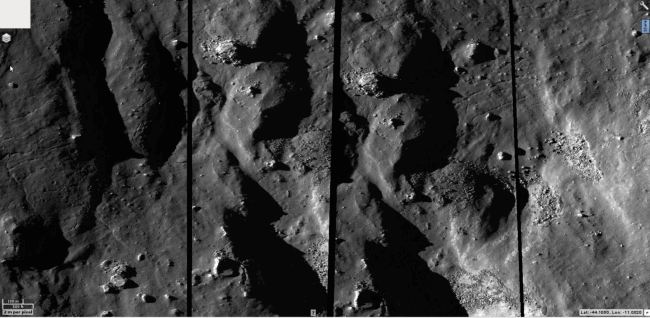
Have a look at this. So innocent yet so simple to deceive. While each strip of duplicate terrain is shown on the map, underneath, there could easily be all kinds of 'features' which are not shown.
Of course, I am sure this duplication is so that they can replace these strips when they have imaged the surface in these areas. Of course it is... Yes, thats it.
In the meantime, to save it being all black because this area has not been mapped by the satellite, they have filled in these areas on the basemap with the same imaged area to the left.
This is exactly how it is on the QuickMap at -44.1050, -11.0020
You really need to go to LROC QuickMap and look at these areas for yourselves, just to make sure I am not pulling your leg...
reply to post by qmantoo
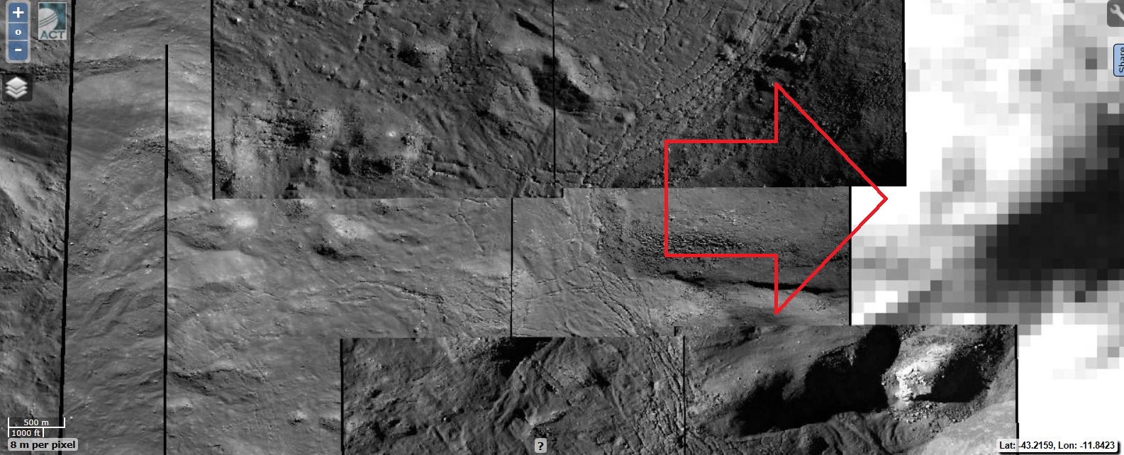
And this is the "Area" of the presumed Alien base in Tycho...
Suspicious... nothing less...
And this is the "Area" of the presumed Alien base in Tycho...
Suspicious... nothing less...
Are there other images showing these same features and the alien civilisation areas? That would provide us proof of what you are saying, but in
greater m per pixels. It is not that I dont believe you, but proof of a cover-up in this instance would be useful to the case.
In another thread, Erik says this
See this thread www.abovetopsecret.com...
In another thread, Erik says this
That would be the handful of students and staff at the Arizona State University that have done that......not NASA.
There was a very interesting article posted on here about how they don't have enough people to scan all the new images that come in to them somewhere here on ATS from several months ago.
That's whom you'd have to complain to as they are the ones that publish and maintain all the images located at the quick maps.
See this thread www.abovetopsecret.com...
reply to post by qmantoo
I love your threads and the dedication to this topic. Keep them coming please.
I'm convinced there's something odd going on up there. I've talked about the moon people for years.
I love your threads and the dedication to this topic. Keep them coming please.
I'm convinced there's something odd going on up there. I've talked about the moon people for years.
reply to post by qmantoo
The pictures are in strips that may be a software error also you could use the search function for that area to find all the LRO images for a selected are which you can draw on the map
You can also share a link to an area you are looking at using the share tab that way we clink on the link and go straight to the area
like this Double Image
You people criticise NASA and you don't even use the resources properly
reply to post by wmd_2008
Yea I have to agree with your wmd_2008. It looks like someone tried to make a landscape view of the surface and failed to piece the pictures together correctly.
Yea I have to agree with your wmd_2008. It looks like someone tried to make a landscape view of the surface and failed to piece the pictures together correctly.
Yes, thanks for the advice about using the share button.
The pictures are in strips that may be a software error also you could use the search function for that area to find all the LRO images for a selected are which you can draw on the map
You can also share a link to an area you are looking at using the share tab that way we clink on the link and go straight to the area
like this Double Image
You people criticise NASA and you don't even use the resources properly
All I was saying is that it would be quite possible to hide anything if NASA wanted to under the duplicate strips. That does not rule out s/w errors, lack of resources, human errors or deliberate covering up.
Criticising NASA for not giving us the real deal as far as photographs has nothing whatever to do with using the resources properly or not. Availability is not the same as usage of what is available. If you believe they are showing us images which are the best they get, then please point to them. As far as I know, the PDS is the place which science is supposed to use to download from and use for their research for writing scientific papers.
reply to post by qmantoo
Here I did a search box around your double image are and asked for all LRO products here is the list.
Region of interest:
Lower-Left corner (lon, lat) = (-11.05813,-44.16686)
Upper-Right corner (lon, lat) = (-10.88322,-44.06212)
Projected extent (in cartographic coordinates):
width (km) = 5.30
height (km) = 3.18
perimeter (km) = 16.96
area (sq. km) = 16.85
LROC NAC images within ROI
(5 records):
image_id,orbit_no,start_time,i_angle,e_angle
M150591659RC, 7326, 2011-01-25 10:46:32, 69.876, 1.158
M181236753RC, 11822, 2012-01-15 03:18:06, 72.571, 1.169
M1096573554LC, 13968, 2012-07-10 15:31:27, 74.625, 1.668
M1096573554RC, 13968, 2012-07-10 15:31:27, 74.707, 1.186
M1114233717RC, 16443, 2013-01-31 01:07:29, 57.841, 1.209
reply to post by wmd_2008
Can you please provide The detailed (0.5meter x pixel) LROC image of that area on that coordinates (43°14' 57.08" S - 11°42'26.03" W)?
Thanks in advance
Can you please provide The detailed (0.5meter x pixel) LROC image of that area on that coordinates (43°14' 57.08" S - 11°42'26.03" W)?
Thanks in advance
Originally posted by Arken
reply to post by wmd_2008
Can you please provide The detailed (0.5meter x pixel) LROC image of that area on that coordinates (43°14' 57.08" S - 11°42'26.03" W)?
Thanks in advance
Will try to get that for Arken will post back later.
Target Area
edit on 22-7-2013
by wmd_2008 because: (no reason given)
The "target" area is still extremely confused and do not match each other....
LROC tool.....
LROC tool.....
Originally posted by Arken
The "target" area is still extremely confused and do not match each other....
LROC tool.....
What are you looking for Arken are your coordinates correct
Originally posted by wmd_2008
Originally posted by Arken
The "target" area is still extremely confused and do not match each other....
LROC tool.....
What are you looking for Arken are your coordinates correct
Yes. Correct. I Try for 1 hour to center the "target Area",... and nothing.
That particular Area seems not imaged at all ,heavily pixellated or covered by other images.
Strange...
edit on 23-7-2013 by Arken because: (no reason given)
Originally posted by Arken
Originally posted by wmd_2008
Originally posted by Arken
The "target" area is still extremely confused and do not match each other....
LROC tool.....
What are you looking for Arken are your coordinates correct
Yes. Correct. I Try for 1 hour to center the "target Area",... and nothing.
That particular Area seems not imaged at all ,heavily pixellated or covered by other images.
Strange...edit on 23-7-2013 by Arken because: (no reason given)
There has not been a image taken of that area yet but it will appear at some point I asked about the coordinates because the link in my post above is CENTERED on the coordinates you gave which is NOT the pixelated area you point to
Originally posted by Arken
reply to post by wmd_2008
Please give an image cropped from that area.
thanks in advance.
The link is a few posts above but here you go.
Originally posted by wmd_2008
Originally posted by Arken
reply to post by wmd_2008
Can you please provide The detailed (0.5meter x pixel) LROC image of that area on that coordinates (43°14' 57.08" S - 11°42'26.03" W)?
Thanks in advance
Will try to get that for Arken will post back later.
[url=http://target.lroc.asu.edu/q3/?proj=eqc¢er=-1311499.986536,-355087.832328&zoom=16
reply to post by wmd_2008
Link don't work. And however that particular area is blank or heavily pixellated.
Can you please crop an image from the "taget area"?
Not link, but your image cropped from the target site of the "Alien base".
Link don't work. And however that particular area is blank or heavily pixellated.
Can you please crop an image from the "taget area"?
Not link, but your image cropped from the target site of the "Alien base".
edit on 24-7-2013 by Arken because: (no reason given)
Originally posted by Arken
reply to post by wmd_2008
Link don't work. And however that particular area is blank or heavily pixellated.
Can you please crop an image from the "taget area"?
Not link, but your image cropped from the target site of the "Alien base".edit on 24-7-2013 by Arken because: (no reason given)
That is centered on the coordinates you gave.
Originally posted by wmd_2008
Originally posted by Arken
reply to post by wmd_2008
Link don't work. And however that particular area is blank or heavily pixellated.
Can you please crop an image from the "taget area"?
Not link, but your image cropped from the target site of the "Alien base".edit on 24-7-2013 by Arken because: (no reason given)
That is centered on the coordinates you gave.
Can You please catch also the COORDINATES on the image, Of the whole Area in the LROC QuickMap ?
Of the whole Area
Originally posted by Arken
reply to post by wmd_2008
Can you please provide The detailed (0.5meter x pixel) LROC image of that area on that coordinates (43°14' 57.08" S - 11°42'26.03" W)?
Thanks in advance
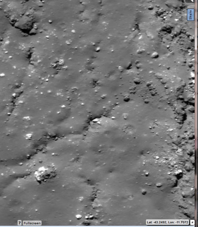
In decimal degrees that's 43.2492 S 11.7072 W
You could have done that yourself
new topics
-
University student disciplined after saying veganism is wrong and gender fluidity is stupid
Education and Media: 22 minutes ago -
Geddy Lee in Conversation with Alex Lifeson - My Effin’ Life
People: 1 hours ago -
God lived as a Devil Dog.
Short Stories: 1 hours ago -
Happy St George's day you bigots!
Breaking Alternative News: 3 hours ago -
TLDR post about ATS and why I love it and hope we all stay together somewhere
General Chit Chat: 4 hours ago -
Hate makes for strange bedfellows
US Political Madness: 6 hours ago -
Who guards the guards
US Political Madness: 9 hours ago -
Has Tesla manipulated data logs to cover up auto pilot crash?
Automotive Discussion: 10 hours ago
top topics
-
Hate makes for strange bedfellows
US Political Madness: 6 hours ago, 14 flags -
whistleblower Captain Bill Uhouse on the Kingman UFO recovery
Aliens and UFOs: 15 hours ago, 11 flags -
Who guards the guards
US Political Madness: 9 hours ago, 10 flags -
TLDR post about ATS and why I love it and hope we all stay together somewhere
General Chit Chat: 4 hours ago, 4 flags -
Happy St George's day you bigots!
Breaking Alternative News: 3 hours ago, 3 flags -
Has Tesla manipulated data logs to cover up auto pilot crash?
Automotive Discussion: 10 hours ago, 2 flags -
God lived as a Devil Dog.
Short Stories: 1 hours ago, 2 flags -
Geddy Lee in Conversation with Alex Lifeson - My Effin’ Life
People: 1 hours ago, 2 flags -
University student disciplined after saying veganism is wrong and gender fluidity is stupid
Education and Media: 22 minutes ago, 2 flags
active topics
-
Remember These Attacks When President Trump 2.0 Retribution-Justice Commences.
2024 Elections • 44 • : Daughter2v2 -
Thousands Of Young Ukrainian Men Trying To Flee The Country To Avoid Conscription And The War
Other Current Events • 117 • : FlyersFan -
Happy St George's day you bigots!
Breaking Alternative News • 30 • : SprocketUK -
Tucker Carlson UFOs are piloted by spiritual entities with bases under the ocean and the ground
Aliens and UFOs • 41 • : FlyersFan -
University student disciplined after saying veganism is wrong and gender fluidity is stupid
Education and Media • 1 • : watchitburn -
"We're All Hamas" Heard at Columbia University Protests
Social Issues and Civil Unrest • 247 • : FlyersFan -
Silent Moments --In Memory of Beloved Member TDDA
Short Stories • 68 • : Encia22 -
British TV Presenter Refuses To Use Guest's Preferred Pronouns
Education and Media • 118 • : Consvoli -
-@TH3WH17ERABB17- -Q- ---TIME TO SHOW THE WORLD--- -Part- --44--
Dissecting Disinformation • 625 • : daskakik -
OUT OF THE BLUE Chilling moment pulsating blue cigar-shaped UFO is filmed hovering over PHX AZ
Aliens and UFOs • 46 • : burritocat