It looks like you're using an Ad Blocker.
Please white-list or disable AboveTopSecret.com in your ad-blocking tool.
Thank you.
Some features of ATS will be disabled while you continue to use an ad-blocker.

Mons Hansteen monolith casts >100m shadow on the Moon
page: 1share:
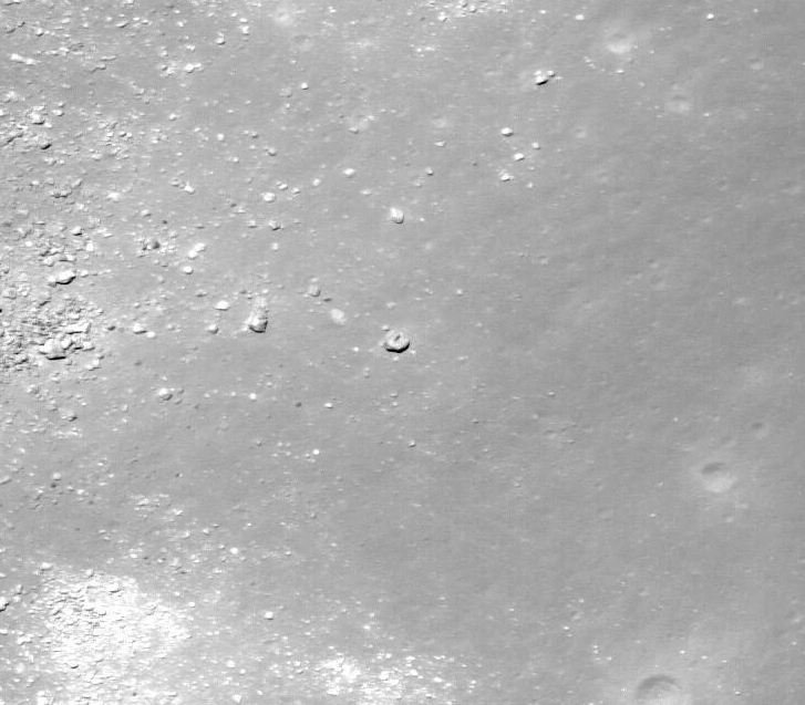
First image of Mons Hansteen was taken by Lunar Orbiter back in the 1960's.
The general coordinates on the moon are -12.25S by -50.25W. Mons Hansteen is the obvious triangular feature which is attended by Crater Hansteen on the north west and Crater Billy on the south. This triangular feature is also know as the "Arrowhead".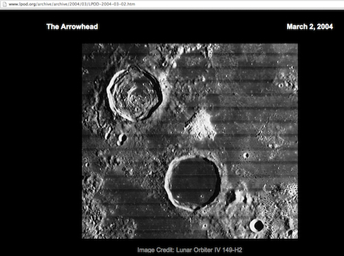
Recent LRO/NAC images of Mons Hansteen have captured the "Arrowhead" as close as 1m per pixel.
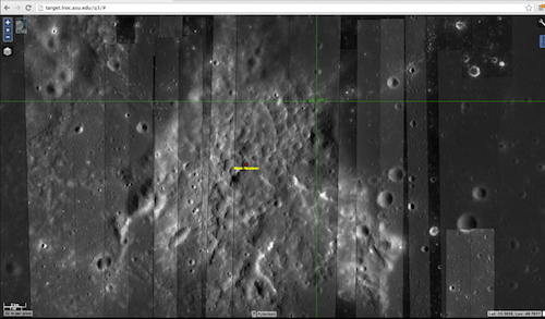
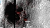
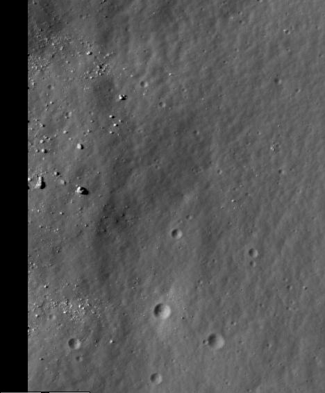
The area that caught my eye is circled in red. You can browse the moon here target.lroc.asu.edu...
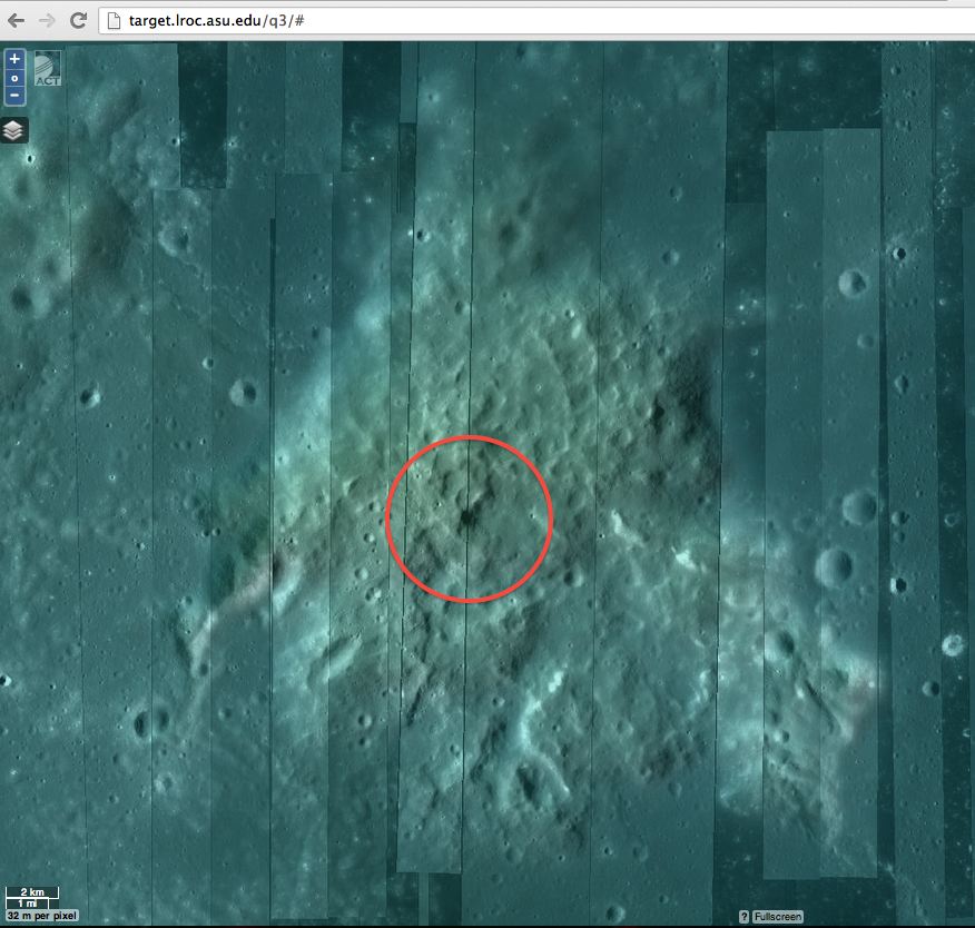
When I zoomed down on the area circled in red I found the very distinctly shadowed area. Scientific studies have the opinion that Mons Hansteen is a volcanic eruption that is younger than the two neighbor craters, Hansteen and Billy. Therefore, Mons Hansteen would not contain any ejecta from those two craters. If Hansteen is a volcanic eruption then this darkly shadowed central area could be a primordial volcanic vent which is younger (in hundreds of millions of years) than the surrounding territories.
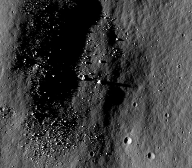
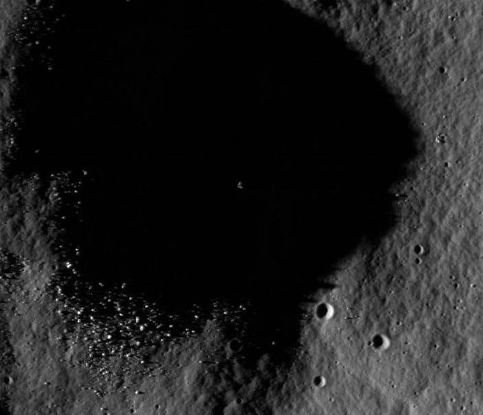
This is what the "vent" looks like when you drill down on the LROC image.
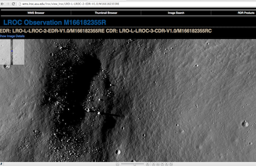
The monolithic shadow is easily identified. The monolith shadow feature is clearly >100m.
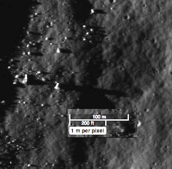
I spent the weekend scanning around all of Mons Hansteen and I was not able to find any other significant shadow features like this. This shadow feature is >100m and it easily exceeds ALL the other shadow lengths of ALL other boulders in the immediate area of the "volcanic vent". It is very unique with respect to available Mons Hansteen images.
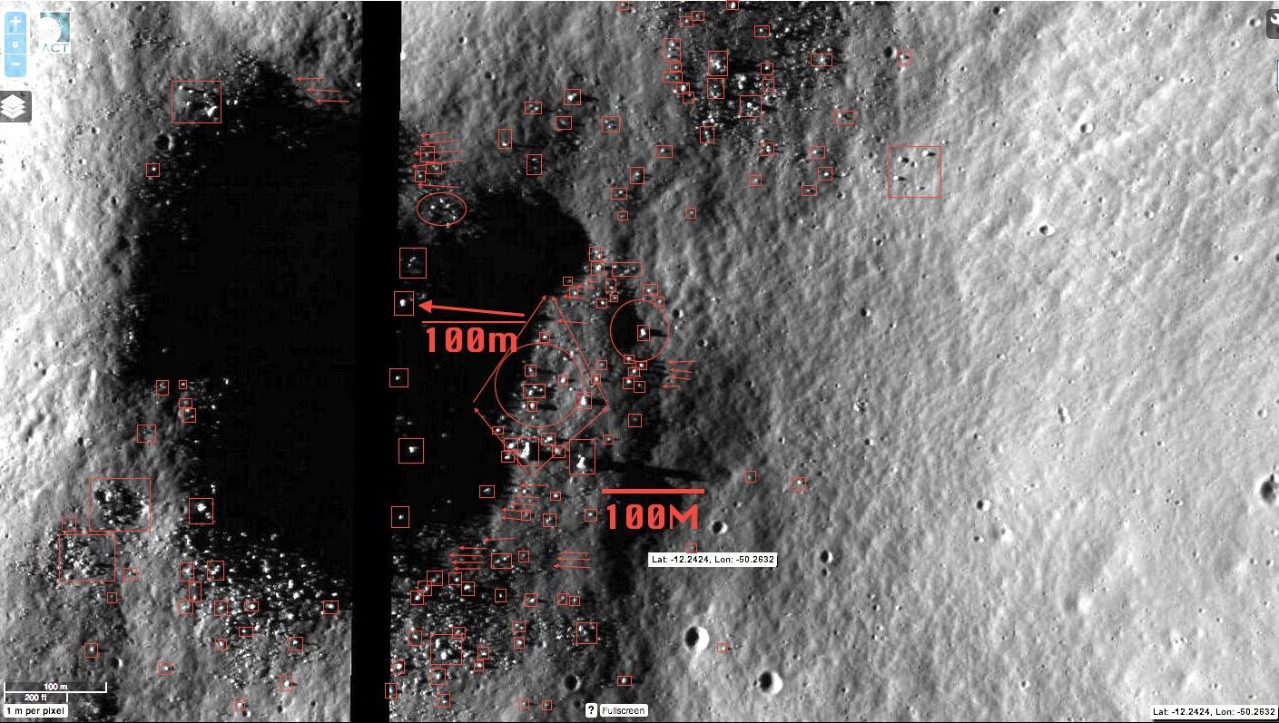
I made this illustration to identify all of the large shadow features that are evident in the LROC M166182355R image.
The Mons Hansteen Monolith is clearly the tallest feature on the "vent".
The Mons Hansteen Monolith is clearly the tallest feature on the "vent".
edit on 6/25/2013 by SayonaraJupiter because: (no reason given)
It's a rock! Ha ha. It is, though! That's what monoliths are kinda, right?
edit on 24-6-2013 by darkbake because: (no reason given)
It would make sense if it was a volcanic vent that had the outer part of the Volcano eroded away. That's where some similar structures originate from
here on Earth as well, from eroded away volcanoes leaving only the Volcanic plug. I'm just saying because there are many wind storms on Mars, and the
erosion and weathering may have also come from previous water sources as well.
Very beautiful and interesting geologic phenomena too.
Very beautiful and interesting geologic phenomena too.
reply to post by VoidFire
I can see your point. Due to the seismic activity attributed to local volcanism, the solidified volcanic tubes would remain intact in situ while the less coherent material would fall away due to seismic and gravitation forces - leaving the darker regolith behind it. This could also explain the strictly linear features of the area cast by the monolithic shadow which I observed it to be linear without exception until the shadow ends with the twin peaks. I include the two shadow peaks at the furthest limits of the shadow, on the East, across the chasm, because they are clear and obvious.
It would make sense if it was a volcanic vent that had the outer part of the Volcano eroded away.
I can see your point. Due to the seismic activity attributed to local volcanism, the solidified volcanic tubes would remain intact in situ while the less coherent material would fall away due to seismic and gravitation forces - leaving the darker regolith behind it. This could also explain the strictly linear features of the area cast by the monolithic shadow which I observed it to be linear without exception until the shadow ends with the twin peaks. I include the two shadow peaks at the furthest limits of the shadow, on the East, across the chasm, because they are clear and obvious.
I think the obvious escapes you.
The hill that the "Monolith" is on casts an almost equally long shadow.
Since the "Monolith" is on top of the hill, I would expect it to cast a slightly longer shadow.
Nothing more than an oblong rock sitting vertically on top of a hill. Pretty sure if you look around ATS you will find many more "Monoliths".
I would love to see some real s&@$ on the moon as much as the next guy, but don't look too deeply or you're gonna be the next guy posting pictures of Guinea Pig Rocks.
If the shadow is on a slope it will appear longer than shadows not on a slope. So the rocks height cannot be determined by its shadow length without
knowledge of the topography of the ground the shadow is cast on. The rock could very well be like all the others in the area, it just looks taller
because of the local topography. Its on a ridge or hilltop so the shadow is cast on a downslope giving it the appearance of being longer than the
others.
Edit: Oops, looks like shadow caught this before I did. Should have read his post.
Edit: Oops, looks like shadow caught this before I did. Should have read his post.
edit on 25-6-2013 by eManym because: (no reason
given)
Originally posted by ShadowLink but don't look too deeply or you're gonna be the next guy posting pictures of Guinea Pig Rocks.
I don't think that this is a Guinea Pig Rock. The shadow is >100m and by orders of magnitude it is longer than any other shadow feature in the area which can be found on Mons Hansteen.
I am not good at trigonometry and I failed geometry. But this image might be useful to someone who could do the math to figure out the relative elevations and the shadow distances involved, which in the end, would compute the true dimensions of this monolithic rock!
I wish I was good at math but it just isn't my thing.
I just noticed your ATS userid! Shadows indeed.....
Just to be clear, what exactly are you getting at?
Are you saying its a monolith, or an eroded volcanic vent or just wanting to know its exact height regardless of what it is?
I agree with you completely that the object appears rather tall.
My personal opinion is that it is just a slender rock. It happens to be the tallest one on the top of the hill, thus it casts the longest shadow.
Couple of shadow examples...
As for a volcanic vent, I really have no opinion on that since geology is not my specialty.
ETA:
You've seen the Guinea Pig Rock on Mars post right?
edit on 25-6-2013 by ShadowLink because: (no reason given)
Originally posted by ShadowLink
Just to be clear, what exactly are you getting at?
Are you saying its a monolith, or an eroded volcanic vent or just wanting to know its exact height regardless of what it is?
I think this could be a volcanic vent but the monolithic block that created the 100m shadow is not part of any volcanic processes. This monolithic shadow feature is utterly unique and must bear further scrutiny. Your guess is as good as mine.
Notice the smaller rocks in the picture? They are casting shadows 10-50m long. This is because (I surmise) the angle of the sun against the moon.
I have a feeling because of the angle of the sun, a pop can might send a 10 ft shadow.
Given this, the object doesn't stand out as much as one might assume. Simply because it casts a hundred meter shadow in this instance, does not mean it stands 100m tall. Unfortunately.
Edit: Also noted by other posters is the topography, which should also be taken into account.
edit on 25-6-2013 by boncho because: (no reason
given)
I find it funny that you're one of the proponents for te moon landing hoax, yet you're here saying in this monolith is real...
I love threads like this!! Good one OP!!
I find structures on the moon so fascinating that I wish I could just teleport up there and see things for myself.
I can only imagine what may be up there, Crystal towers, Massive structures, derelict ships, alien skeletal remains strewn across a vast field from some long distance horrific battle...........
Replies above are correct, a shadow cast downslope will be longer than on flat ground.
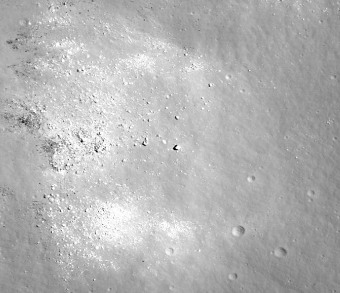
Anyhoo, I like to have an idea of what I'm looking at from several LRO images of the same location, taken at different sun angles. Notice that in the WAC image (the wide angle one) there's no hint of the dark vent; in fact that spot is actually bright. The articles on Mons Hansteen say it's thought to be "an extrusive volcanic mound". I'm not an expert on volcanism, so maybe this thing is somehow different from a typical volcano. This may be just a big pile of material pushed out of the interior by volcanic forces.
Here are the NAC images covering that area:
wms.lroc.asu.edu...
wms.lroc.asu.edu...
wms.lroc.asu.edu...
wms.lroc.asu.edu...
wms.lroc.asu.edu...
wms.lroc.asu.edu...
I'll try to zero-in on the "vent" if I can, and post screenies here.
P.S. ok, here they are:
OP's image, M166182355RC
At higher sun angle, M183853525LC
The shadow is radically shorter, similar in length to that of the nearby monolith.
Sun almost overhead, shadow pointing the other way, M127259935RC
While the monolith is obviously the tallest of the nearby rocks, the shadow isn't that much longer.
Here's an interesting image, M1112139088LC
The whole area is in shadow, but the tip of the monolith catches the sun.
Aha! The best image yet, M140237118RC (0.489 m/p resolution)
Sun is overhead, so almost no shadow, but the great resolution shows it to be nothing but a big rock.
P.P.S. That shadowed area that caught your eye seems to be simply a slope of a hill or ridge. It's on the edge of the large relatively flat area to the right of the monolith.
Oh, just found out that the QuickMap allows you to make a 3D visualisation of the selected terrain
A closeup, very rough geometry, but shows that it's a big rounded slope (click and drage image to rotate the view): target.lroc.asu.edu...
A wider view of the area: target.lroc.asu.edu...
edit on 25-6-2013 by wildespace because: (no reason given)
In M166182355RC, The Sun is ~27 degrees above the horizon for the
rock. Assuming the rock is 10 meters tall and the shadow is 110 meters long, the slope down from the rock would be ~22 degrees.
3D visualisation of the whole "Arrowhead": target.lroc.asu.edu...
The "vent" is at the long sunlit slope near the center. Chose "Vertical exaggeration: 5x" and rotate the view around. I don't think there's any vent clearly visible there.
Here's a gif animation of the monolith at various sun angles, using the NAC images shown above: www.pictureshack.us...
The "vent" is at the long sunlit slope near the center. Chose "Vertical exaggeration: 5x" and rotate the view around. I don't think there's any vent clearly visible there.
Here's a gif animation of the monolith at various sun angles, using the NAC images shown above: www.pictureshack.us...
edit on 25-6-2013 by wildespace because: (no reason given)
I see a lot of talk in the thread about erosion on the Moon.
By what manner is this erosion occurring?
Running water, or wind?
I know they have found evidence of ice in the Moon, but I don't recall there being evidence of running water or water caused erosion.
By what manner is this erosion occurring?
Running water, or wind?
I know they have found evidence of ice in the Moon, but I don't recall there being evidence of running water or water caused erosion.
Originally posted by butcherguy
I see a lot of talk in the thread about erosion on the Moon.
By what manner is this erosion occurring?
Running water, or wind?
I know they have found evidence of ice in the Moon, but I don't recall there being evidence of running water or water caused erosion.
Good question. Here's a couple of links I pulled: blog.moonzoo.org... and forum.moonzoo.org...
So it looks like lots of different factors: space weathering such as meteor impacts and solar wind, day/night temperature difference, geologic (or should I say selenologic) activity such as moonquakes.
new topics
-
Who guards the guards
US Political Madness: 1 hours ago -
Has Tesla manipulated data logs to cover up auto pilot crash?
Automotive Discussion: 3 hours ago -
whistleblower Captain Bill Uhouse on the Kingman UFO recovery
Aliens and UFOs: 8 hours ago -
1980s Arcade
General Chit Chat: 10 hours ago -
Deadpool and Wolverine
Movies: 11 hours ago
top topics
-
Lawsuit Seeks to ‘Ban the Jab’ in Florida
Diseases and Pandemics: 15 hours ago, 20 flags -
Starburst galaxy M82 - Webb Vs Hubble
Space Exploration: 17 hours ago, 13 flags -
CIA botched its handling of sexual assault allegations, House intel report says
Breaking Alternative News: 13 hours ago, 8 flags -
15 Unhealthiest Sodas On The Market
Health & Wellness: 17 hours ago, 6 flags -
whistleblower Captain Bill Uhouse on the Kingman UFO recovery
Aliens and UFOs: 8 hours ago, 6 flags -
1980s Arcade
General Chit Chat: 10 hours ago, 4 flags -
Deadpool and Wolverine
Movies: 11 hours ago, 4 flags -
Teenager makes chess history becoming the youngest challenger for the world championship crown
Other Current Events: 12 hours ago, 3 flags -
Who guards the guards
US Political Madness: 1 hours ago, 1 flags -
Has Tesla manipulated data logs to cover up auto pilot crash?
Automotive Discussion: 3 hours ago, 0 flags
active topics
-
Deadpool and Wolverine
Movies • 2 • : chiefsmom -
Has Tesla manipulated data logs to cover up auto pilot crash?
Automotive Discussion • 2 • : seekshelter -
Candidate TRUMP Now Has Crazy Judge JUAN MERCHAN After Him - The Stormy Daniels Hush-Money Case.
Political Conspiracies • 622 • : Lazy88 -
Scientists Say Even Insects May Be Sentient
Science & Technology • 55 • : AdultMaleHumanUK -
"We're All Hamas" Heard at Columbia University Protests
Social Issues and Civil Unrest • 201 • : TheWoker -
-@TH3WH17ERABB17- -Q- ---TIME TO SHOW THE WORLD--- -Part- --44--
Dissecting Disinformation • 610 • : Justoneman -
Lawsuit Seeks to ‘Ban the Jab’ in Florida
Diseases and Pandemics • 24 • : VariedcodeSole -
23,000 Dead People Registered Within a Two Week Period In One State
US Political Madness • 40 • : IndieA -
whistleblower Captain Bill Uhouse on the Kingman UFO recovery
Aliens and UFOs • 7 • : pianopraze -
CIA botched its handling of sexual assault allegations, House intel report says
Breaking Alternative News • 6 • : watchitburn