It looks like you're using an Ad Blocker.
Please white-list or disable AboveTopSecret.com in your ad-blocking tool.
Thank you.
Some features of ATS will be disabled while you continue to use an ad-blocker.

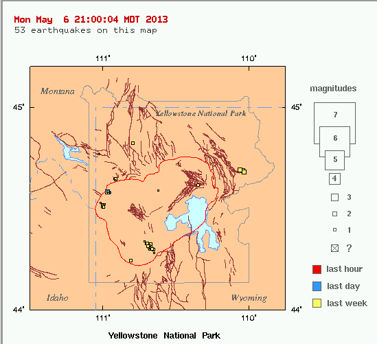
New Quake Swarm Invades Yellowstone- inside the caldera
page: 2share:
Does anyone know if there is public data which shows the amount of the rise and fall of this area. I know they can measure this kind of thing from
space to very high degree of accuracy but... is it available to the public in near real-time? Somehow I doubt it but I might be wrong.
At one time, I did try to find some data relating to the lake water height around the Yellowstone caldera and I seem to remember it was very old data and not anywhare near real-time. Perhaps this is because the universities do not think we plebs can understand it and should concern our pretty little heads about such matters. I think that if I could find these kinds of data, I could plot one kind of data against another or correllate them somehow. A fall in water level and a rise in land level might give us a glimpse of what is going on in the area.
Could be that some sites have a sympathetic harmony with others and when one site goes off, then another either preceeds or follows it with 'sympathy pangs' of a lesser degree. I know this sounds odd, but looking at the Earth as a whole, some parts must be connected to others in way in which we dont understand (but the ancients did understand perhaps)
At one time, I did try to find some data relating to the lake water height around the Yellowstone caldera and I seem to remember it was very old data and not anywhare near real-time. Perhaps this is because the universities do not think we plebs can understand it and should concern our pretty little heads about such matters. I think that if I could find these kinds of data, I could plot one kind of data against another or correllate them somehow. A fall in water level and a rise in land level might give us a glimpse of what is going on in the area.
TA - are these protocols available? I assume they are the ones from the recording instruments to the receiving stations. Is there a write-up somewhere that would explain this to me please?
Umm, after contacting the developer when I received a certain message from IRIS, the fate of GEE is unclear. Because IRIS is moving towards IWS, or IRIS Web Services, and they are terminating some protocols that are implemented in GEE. So the developer told me it was a question of time and (no) money whether GEE would be updated to incorporate the new protocols being used by IWS- so that GEE could continue to function. You may see GEE stop working entirely after April. I know. Sowwy. Bad news.
Could be that some sites have a sympathetic harmony with others and when one site goes off, then another either preceeds or follows it with 'sympathy pangs' of a lesser degree. I know this sounds odd, but looking at the Earth as a whole, some parts must be connected to others in way in which we dont understand (but the ancients did understand perhaps)
reply to post by TrueAmerican
I found this interesting and maybe a red flag..don't know enough to guess.
hisz.rsoe.hu...
I found this interesting and maybe a red flag..don't know enough to guess.
hisz.rsoe.hu...
I don't think many people are quite aware of how much snow accumulates in the Yellowstone area of Idaho and Wyoming. My brother lives in Island Park
which is roughly 40 miles west of Yellowstone Park, near the west entrance. He also works there as head HVAC tech. At different times, his wife who is
active on Facebook will comment on an extraordinary snowfall event or extraordinary low temperatures.
My point is..... the snow overburden at times can reach 20 feet or more in depth, though recently as little as a decade or so ago, My Brother was complaining of sparse snowfall for that year since he is active in snowmobile racing and different outdoor activities.
Try to imagine the weight of the overburden snow on the caldera pushing down. The caldera is something like I believe 40 miles in diameter ? Not sure the exact surface area, but that number seems to be information I had read in the past as an aside. Regardless the exact surface area, it comprises a huge area for snow accumulation and the corresponding weight.
Spring comes late to Yellowstone, but the melt has already began, and don't forget as the winter season changes the thermal activity increases due to the increased heat making it to the surface, minus the snows cooling heat sink action. Less cooling on the surface = more heat making it to the surface and increased melt. My guess is that it is simply overburden melt and the decreased weight of the snow on the caldera, thus springing back to it's relaxed 'mean' elevation when there is no snow.
edit on 17-4-2013 by Plotus because: (no reason given)
Hi TA, you keep mentioning "the scientists', why don't you do a college degree in this stuff and get a job doing what you love? Or do you have a
better job already?
Thanks for you posts anyway. Will you be finishing the last survivors story?
Thanks for you posts anyway. Will you be finishing the last survivors story?
Originally posted by xmaddness
reply to post by Heliophant
I'm guessing the area is already under great pressure, as it has been shown the land over top does move up and down. I'm thinking digging the top open would be akin to bringing a needle to a balloon. It may just pop!
S+F for keeping watch on this beast. Someone needs to do it.
edit on 16-4-2013 by xmaddness because: (no reason given)
Don't forget that Deepwater Horizon oil spill. They drilled down into a salt dome containing a mix of gas and oil that was at 120,000 psi . In comparison, an airplane tire is at 180 psi
I notice another swarm of micro-earthquakes from earlier today, but it seems to be located under/near the east side of the lake; not in the same spot
as the swarm TA was watching. This pic is from station B208, which is located at the north end of lake. You can click on any of the seismos (black
triangles) from the Yellowstone Observatory monitoring page,
or check the seismos here: www.isthisthingon.org...
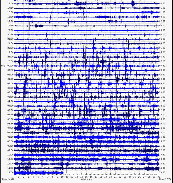
She's a restless caldera this week...
She's a restless caldera this week...
Not that this is necessarily related, and probably posted here somewhere and I couldn't find it, but I saw this today
www.foxnews.com...
www.foxnews.com...
The surest way to get Yellowstone to stop swarming with quakes- is to post it when YS starts swarming with quakes. It appears she hates to be
observed. Happens all the time. Swarm comes up, it gets posted, and *poof*- activity stops.
I don't really care about the science involved if Yellowstone blows.
Life as we know it would never be the same.
You can take that to the bank my friends.
Life as we know it would never be the same.
You can take that to the bank my friends.
reply to post by TrueAmerican
My understanding is that this does indeed happen and I can recall some discussion of this. Unfortunately I don't remember on which thread and to which seismo it related. Tree root rock shows as small sharp normally single line (up and down) spikes on the seismos.
and the fact that I can't seem to get a straight answer out of anyone if tree roots under wind stress could generate enough power to actually propagate .1 to 1 Hz far enough into a seismometer.
My understanding is that this does indeed happen and I can recall some discussion of this. Unfortunately I don't remember on which thread and to which seismo it related. Tree root rock shows as small sharp normally single line (up and down) spikes on the seismos.
Originally posted by TrueAmerican
The surest way to get Yellowstone to stop swarming with quakes- is to post it when YS starts swarming with quakes. It appears she hates to be observed. Happens all the time. Swarm comes up, it gets posted, and *poof*- activity stops.
No, no, no. It is simply that YS sees you have posted and says Oops, better behave. TA is watching.
Let's face it, it needs to get to 2009 proportions before it becomes interesting!!
Originally posted by PuterMan
Tree root rock shows as small sharp normally single line (up and down) spikes on the seismos.
I'd be much more curious what it looks like on a spectrogram. Got a pic for me on that? Cause I'm having a hard time seeing what I've seen on MCID as tree root noise.
Funny, one of the "criteria" for pre-eruptive concerns that scientists have for Yellowstone is multiple swarms of microquakes. It's listed right on USGS's own site. Don't have the link handy, but I know this because you guys may remember that through writing to certain contacts, I helped light a fire under their butts to start tracking swarms at Yellowstone for this very reason. And so they started reporting on this in the updates, which I appreciated.
Well?
www.seis.utah.edu...
Multiple swarms of microquakes. In different locations. There's at least five I see there.
I commented to them before about the apparent "change" in seismicity, with wide dispersion of activity over different parts of the park, and received no reply on that issue directly.
Not sure anyone knows what to think about it. Even in 2008-2009 with all that activity they didn't raise the alert level that I recall. I could be wrong on that, not sure. But what is "elevated seismicity beyond background levels" considered to be anymore at Yellowstone, such that it would cause them to raise the alert level? I mean seismicity is so high there already, that if in 2008 they didn't raise it, or even in the period of caldera uplift from 2000-2010, then it seems it would take some seriously big quakes and multi swarms of very high intensity at this point to raise it.
Of course. There are millions of dollars in tourism at stake here.
But yeah, I must express some concern at this apparent change in seismic character. It is apparent to me, anyway, from my many years of watching it. And I would venture that swarms over the last year have been increasing from previous years. I have a thread around here somewhere where I was tracking YS swarms by the month, but lost interest. And I think they want to see at least 15 events close together at this point for it to be considered a swarm, so what I am seeing as five, they may only regard as one- or none. But there is no denying that there are at least "pockets of multi activity." The fact that they are occurring all over the park, and not just confined to one area, is what is troubling me.
edit on Mon
May 6th 2013 by TrueAmerican because: (no reason given)
3.0 Earthquake today at Yellowstone.
www.seis.utah.edu...
Magnitude 3.0 - local magnitude (Ml)
Time Tuesday, May 7, 2013 at 7:22:33 AM (MDT)
Tuesday, May 7, 2013 at 13:22:33 (UTC)
Distance from West Yellowstone, MT - 14 km (9 miles) SE (127 degrees)
Island Park, ID - 31 km (19 miles) ENE (72 degrees)
Gardiner, MT - 54 km (33 miles) SSW (202 degrees)
Warm River, ID - 60 km (37 miles) NNE (28 degrees)
Salt Lake City, UT - 433 km (269 miles) N (10 degrees)
Coordinates 44 deg. 35.2 min. N (44.587N), 110 deg. 57.9 min. W (110.965W)
Depth 8.6 km (5.3 miles)
Location Quality Good
Location Quality Parameters Nst= 41, Nph= 41, Dmin=9 km, Rmss=0.15 sec, Erho=0.2 km, Erzz=0.5 km, Gp=39.6 degrees
Event ID# uu60022497
new topics
-
Sunak spinning the sickness figures
Other Current Events: 8 minutes ago -
Nearly 70% Of Americans Want Talks To End War In Ukraine
Political Issues: 19 minutes ago -
Late Night with the Devil - a really good unusual modern horror film.
Movies: 2 hours ago -
Cats Used as Live Bait to Train Ferocious Pitbulls in Illegal NYC Dogfighting
Social Issues and Civil Unrest: 3 hours ago -
The Good News According to Jesus - Episode 1
Religion, Faith, And Theology: 5 hours ago -
HORRIBLE !! Russian Soldier Drinking Own Urine To Survive In Battle
World War Three: 7 hours ago -
Bobiverse
Fantasy & Science Fiction: 10 hours ago -
Florida man's trip overseas ends in shock over $143,000 T-Mobile phone bill
Social Issues and Civil Unrest: 10 hours ago
top topics
-
Florida man's trip overseas ends in shock over $143,000 T-Mobile phone bill
Social Issues and Civil Unrest: 10 hours ago, 8 flags -
SETI chief says US has no evidence for alien technology. 'And we never have'
Aliens and UFOs: 14 hours ago, 7 flags -
Cats Used as Live Bait to Train Ferocious Pitbulls in Illegal NYC Dogfighting
Social Issues and Civil Unrest: 3 hours ago, 7 flags -
This is our Story
General Entertainment: 17 hours ago, 4 flags -
Former Labour minister Frank Field dies aged 81
People: 12 hours ago, 4 flags -
Bobiverse
Fantasy & Science Fiction: 10 hours ago, 3 flags -
Late Night with the Devil - a really good unusual modern horror film.
Movies: 2 hours ago, 2 flags -
HORRIBLE !! Russian Soldier Drinking Own Urine To Survive In Battle
World War Three: 7 hours ago, 2 flags -
The Good News According to Jesus - Episode 1
Religion, Faith, And Theology: 5 hours ago, 0 flags -
Nearly 70% Of Americans Want Talks To End War In Ukraine
Political Issues: 19 minutes ago, 0 flags
active topics
-
Truth Social goes public, be careful not to lose your money
Mainstream News • 124 • : lilzazz -
British TV Presenter Refuses To Use Guest's Preferred Pronouns
Education and Media • 145 • : Annee -
President BIDEN Vows to Make Americans Pay More Federal Taxes in 2025 - Political Suicide.
2024 Elections • 105 • : ImagoDei -
Nearly 70% Of Americans Want Talks To End War In Ukraine
Political Issues • 2 • : Consvoli -
Sunak spinning the sickness figures
Other Current Events • 0 • : annonentity -
Cats Used as Live Bait to Train Ferocious Pitbulls in Illegal NYC Dogfighting
Social Issues and Civil Unrest • 9 • : ImagoDei -
Late Night with the Devil - a really good unusual modern horror film.
Movies • 3 • : Hecate666 -
HORRIBLE !! Russian Soldier Drinking Own Urine To Survive In Battle
World War Three • 23 • : Disgusted123 -
Hi folks I'm Leon Grad
Introductions • 9 • : leongrad -
The Reality of the Laser
Military Projects • 41 • : 5thHead