It looks like you're using an Ad Blocker.
Please white-list or disable AboveTopSecret.com in your ad-blocking tool.
Thank you.
Some features of ATS will be disabled while you continue to use an ad-blocker.

Ancient Items That Shouldn't Exist (OOPARTs)
page: 1share:
Greetings, ATS!
Today I bring you a series of ancient enigmas....cities and items that should not exist, according to traditional archaeology. I’ve left out a lot of the more “common” items that generally garner attention, such as the Baghdad Battery and the Dropa Stones, to focus on items less well known. It is my hope that you will find something new in this discussion.
So let’s get started. First up….The Mysterious City of Nan Madol
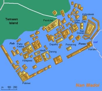
Nan Madol is an ancient Megalithic city built off the coast of the Federated States of Micronesia. What makes this city unique is the fact that it’s built in the water, using huge slabs of rocks (some weighing more than 60 tons) to form basalt walls 18-25 feet high and over 17 feet thick. Just one of these slabs could weigh upwards of 50 tons, so the question becomes….how did the people of Nan Madol move these gigantic slabs? Archeologists do not know.
One hypothesis is that the slabs, quarried from the opposite side of the island, were floated to the site on rafts. However, this hypothesis proved inaccurate, as archeologists attempted to float a stone slab of the same size on a raft (it sank like, well, a rock).
According to ancient tradition, the people of Nan Madol explained the building of their city as the work of “magicians, who flew the rocks into place.” Another explanation involved the use of giants who were strong enough to maneuver the huge slabs.
Interestingly enough, the slabs also form islands in the city (see picture above). There are a series of underwater tunnels that start at the center of the city and connect to various islands, possibly as an escape route. Archaeologists declared the tunnels man-made, yet cannot explain how the people made the tunnels.
So how did the builders move the huge slabs of rock and create the underwater tunnels? Do the folktales point to the truth…or could it be that the civilization had tools we are unfamiliar with to do the heavy moving? We may never know.
additional source
Up next….The Acambaro Figurines
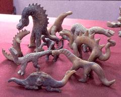
The Acambaro Figurines are either an elaborate hoax or a most amazing discovery, depending upon your source. I’ll leave that conclusion to you, and simply present what I’ve uncovered in my research for your consideration.
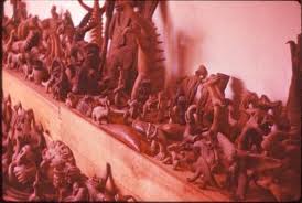
In 1944, German entrepreneur Waldemar Julsrud uncovered several clay figurines near the banks of Cerro del Toro in Acámbaro, Guanjato, Mexico. Julsrud, intrigued by the figurines, later employed local farmers to dig up and bring the unusual items to him. Eventually, the collection numbered approximately 32,000 pieces.
Here’s the interesting part. The figurines appear to represent dinosaurs and other extinct animals that existed before humans.
This raises a rather obvious question: how did the creators of the clay figurines know what a dinosaur (or the other animals) looked like? Was the knowledge passed down through generations, perhaps from an advanced civilization that knew about such creatures? Or is there a more prosaic explanation?
Some of the critics of the Acambaro Figurines claim that the figurines are outright hoaxes. These critics claim the local farmers and artisans created the figurines for money. Others believe the fact that the figurines were found in only one part of the archeological site also points to fraud or hoax.
Could these figurines indicate that humans once walked with dinosaurs? Or are they simply the fabrication of a gifted hoaxer? I leave that decision to you, ATS.
Today I bring you a series of ancient enigmas....cities and items that should not exist, according to traditional archaeology. I’ve left out a lot of the more “common” items that generally garner attention, such as the Baghdad Battery and the Dropa Stones, to focus on items less well known. It is my hope that you will find something new in this discussion.
So let’s get started. First up….The Mysterious City of Nan Madol
Nan Madol is an ancient Megalithic city built off the coast of the Federated States of Micronesia. What makes this city unique is the fact that it’s built in the water, using huge slabs of rocks (some weighing more than 60 tons) to form basalt walls 18-25 feet high and over 17 feet thick. Just one of these slabs could weigh upwards of 50 tons, so the question becomes….how did the people of Nan Madol move these gigantic slabs? Archeologists do not know.
One hypothesis is that the slabs, quarried from the opposite side of the island, were floated to the site on rafts. However, this hypothesis proved inaccurate, as archeologists attempted to float a stone slab of the same size on a raft (it sank like, well, a rock).
According to ancient tradition, the people of Nan Madol explained the building of their city as the work of “magicians, who flew the rocks into place.” Another explanation involved the use of giants who were strong enough to maneuver the huge slabs.
One local folktale told of giants living on the island, who probably had the physical means to carry the heavy logs and build the walls. Another legend tells the story of two brothers named Olosopha and Olosipha, who used their magic powers to transport the logs from a far-away land by making them fly.
Another tale tells of a magician, who, like the two brothers, made the logs fly towards Nan Madol for the city to be constructed. All these local accounts tell of the basalt logs coming from a far-away place because there was no other source of basalt stones near Nan Madol, except in a location on the opposite side of the island.
Interestingly enough, the slabs also form islands in the city (see picture above). There are a series of underwater tunnels that start at the center of the city and connect to various islands, possibly as an escape route. Archaeologists declared the tunnels man-made, yet cannot explain how the people made the tunnels.
So how did the builders move the huge slabs of rock and create the underwater tunnels? Do the folktales point to the truth…or could it be that the civilization had tools we are unfamiliar with to do the heavy moving? We may never know.
additional source
Up next….The Acambaro Figurines
The Acambaro Figurines are either an elaborate hoax or a most amazing discovery, depending upon your source. I’ll leave that conclusion to you, and simply present what I’ve uncovered in my research for your consideration.
In 1944, German entrepreneur Waldemar Julsrud uncovered several clay figurines near the banks of Cerro del Toro in Acámbaro, Guanjato, Mexico. Julsrud, intrigued by the figurines, later employed local farmers to dig up and bring the unusual items to him. Eventually, the collection numbered approximately 32,000 pieces.
Here’s the interesting part. The figurines appear to represent dinosaurs and other extinct animals that existed before humans.
While the figures appeared to be of ancient origin, their depictions were quite controversial and began to attract attention among skeptics in the scientific community. The Acámbaro figures portrayed not only dinosaurs but also unknown animals as well as those that had long been extinct. The figures also included camels and other animals not known to the area, as well as depictions of faraway cultures.
In 1972, carbon-14 analysis was made of various figures kept at the Museum of Pennsylvania, in Philadelphia. Laboratory tests showed that the objects were 5,000 years old. Four years beforehand at Isotopes Inc. in New Jersey, thermo-luminosity tests revealed that the approximate age was around 6,000 to 1,500 years old.
The archeologist and the regional director of the Acámbaro National Museum of Archeology enlisted various authorities to testify to the authenticity of the figures, including the paleontologist at the EUA Natural History Museum, naturalist Dr. Gaylord Simpson; Ivan T. Sanderson; and attorney/criminologist Erle Gardner.
This raises a rather obvious question: how did the creators of the clay figurines know what a dinosaur (or the other animals) looked like? Was the knowledge passed down through generations, perhaps from an advanced civilization that knew about such creatures? Or is there a more prosaic explanation?
Some of the critics of the Acambaro Figurines claim that the figurines are outright hoaxes. These critics claim the local farmers and artisans created the figurines for money. Others believe the fact that the figurines were found in only one part of the archeological site also points to fraud or hoax.
Could these figurines indicate that humans once walked with dinosaurs? Or are they simply the fabrication of a gifted hoaxer? I leave that decision to you, ATS.
edit on 8-4-2013 by smyleegrl because: (no reason given)
edit on 9-4-2013 by Gazrok because: Added OOPARTs to
subject for easier searching (Out Of Place ARTifacts)
The Map of the Creator
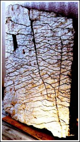
In 1999, Vladimir Krainov showed a stone slab to Professor Alexander Chuvyrov from Bashkir State University. For years, Krainov used the slab as a stepping stone to his house. But the stone was sinking, and Krainov decided to dig it up and turn it into gravel.
Hearing about the stone slab, Professor Chuvyrov examined it and proclaimed the slab a significant find in ancient archeology. The stone appeared to be marked with strange hieroglyphic type markings and covered with a porcelain finish.
A team of experts later determined the markings were not, as originally speculated, ancient Chinese. Nor was the porcelain finish a product made in China. In fact, the team did not know what the markings represented, or how the item had been manufactured.
“After extensive study it was determined to be a three dimensional relief map of the Ural Region showing remarkably precise dimensions. The stone was said to contain accurate representations of civil engineering work, irrigation systems and dams.
To create such a masterpiece would require a technology modern day scientist’s claim, couldn’t have existed at the time it was created, which was estimated to be over 100 million years ago. The map also showed not only the Ural Region, but the Belya, Ufimka and Sutolka rivers. Later studies revealed it was a piece of a larger artifact, perhaps a world map.”
A relief map created 100 million years ago….or a hoax? Is it possible to date the markings on the stone itself?
Some scientists believe the “map” is a natural phenomenon, and that people simply are seeing what they want to see. Could this be the explanation for the Map of the Creator? Or could the explanation lie in the vast recesses of our history?
The Aluminum Wedge of Aiud
I had a hard time finding a “credible” source for the topic of the Aluminum Wedge. Most of the sources I came across consisted of blogs, ancient alien webpages, and the like. I feel these sources are biased, but will present what I found and leave the final determination to you.
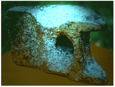
In 1974 Romania, workers unearthed three objects. Two of the objects proved to be mastodon bones, dated to the Miocene and Pleistocene periods. The third object, however, was strange indeed.
It was a block of metal, similar in appearance to the head of a hammer. Unsure of the object’s ultimate identity, the scientists sent it off to be tested and studied.
According to the tests, the item is composed of 89% aluminum alloy, which does not occur naturally in nature. Therefore, the item must have been manufactured. Supporting this claim is the shape and design of the object, which does indeed appear artificial.
So….how to date the item? Since it was found in the same strata as the mastodon bones, should it be dated to the same time period, several million years ago? Is it the landing gear of an airplane or other flying object…perhaps a time machine or alien in origin? Or is it simply a hoax, an internet rumor with no truth or substance?
Well, there you have it, ATS. I hope you enjoyed reading this, and more importantly, I hope you will consider the arguments with an open mind.
In 1999, Vladimir Krainov showed a stone slab to Professor Alexander Chuvyrov from Bashkir State University. For years, Krainov used the slab as a stepping stone to his house. But the stone was sinking, and Krainov decided to dig it up and turn it into gravel.
Hearing about the stone slab, Professor Chuvyrov examined it and proclaimed the slab a significant find in ancient archeology. The stone appeared to be marked with strange hieroglyphic type markings and covered with a porcelain finish.
A team of experts later determined the markings were not, as originally speculated, ancient Chinese. Nor was the porcelain finish a product made in China. In fact, the team did not know what the markings represented, or how the item had been manufactured.
“After extensive study it was determined to be a three dimensional relief map of the Ural Region showing remarkably precise dimensions. The stone was said to contain accurate representations of civil engineering work, irrigation systems and dams.
To create such a masterpiece would require a technology modern day scientist’s claim, couldn’t have existed at the time it was created, which was estimated to be over 100 million years ago. The map also showed not only the Ural Region, but the Belya, Ufimka and Sutolka rivers. Later studies revealed it was a piece of a larger artifact, perhaps a world map.”
A relief map created 100 million years ago….or a hoax? Is it possible to date the markings on the stone itself?
“Chuvyrov, being a physicist, noted “…the relief has not been manually made by an ancient stonecutter. It is simply impossible. It is obvious that the stone was machined." X-ray photographs confirmed the slab was of artificial origin and had been made with precision tools.
The longer the slab was studied, the more mysterious it became. There were two 500-metre-wide channel systems, 12 dams, 300-500 meters wide, approximately 10 km long and 3 km deep each. In comparison, modern day irrigation systems would appear to be mere scratches on one of today’s relief maps. It was obvious the map had been created for aerial navigation as there were no roads or highways.
But, there were no airplanes at the time it was made…was there? According to Chuvyrov, to produce such an intricately designed map would require a super computer. So, who created this map, extraterrestrials? Not wanting to be identified as UFO “wack job,” Chuvyrov decided to call the stone the “Map of the Creator.” Chuvyrov also expressed doubts as to whether even today’s sophisticated cartographers could make a three dimensional map of equal caliber.
Some scientists believe the “map” is a natural phenomenon, and that people simply are seeing what they want to see. Could this be the explanation for the Map of the Creator? Or could the explanation lie in the vast recesses of our history?
The Aluminum Wedge of Aiud
I had a hard time finding a “credible” source for the topic of the Aluminum Wedge. Most of the sources I came across consisted of blogs, ancient alien webpages, and the like. I feel these sources are biased, but will present what I found and leave the final determination to you.
In 1974 Romania, workers unearthed three objects. Two of the objects proved to be mastodon bones, dated to the Miocene and Pleistocene periods. The third object, however, was strange indeed.
It was a block of metal, similar in appearance to the head of a hammer. Unsure of the object’s ultimate identity, the scientists sent it off to be tested and studied.
According to the tests, the item is composed of 89% aluminum alloy, which does not occur naturally in nature. Therefore, the item must have been manufactured. Supporting this claim is the shape and design of the object, which does indeed appear artificial.
The object is covered with a thick layer of aluminum oxide. After the analysis of this layer, the specialist affirmed that the object is at least 300 to 400 years old.
This result puzzled the researchers because pure aluminum was not readily obtainable until the middle of the 19th century.
Other specialists claim that the object could be 20,000 years old because it was found in a layer with mastodon bone. Perhaps this particular specimen lived in the latter part of the Pleistocene.
Some researchers suppose that this piece of metal was part of a flying object that had fallen into the river. They presume that it had an extraterrestrial origin. Other researchers affirm that it was made on Earth and was part of a tool. The purpose of this tool is unknown.
So….how to date the item? Since it was found in the same strata as the mastodon bones, should it be dated to the same time period, several million years ago? Is it the landing gear of an airplane or other flying object…perhaps a time machine or alien in origin? Or is it simply a hoax, an internet rumor with no truth or substance?
Well, there you have it, ATS. I hope you enjoyed reading this, and more importantly, I hope you will consider the arguments with an open mind.
edit on 8-4-2013 by smyleegrl because: (no reason given)
reply to post by smyleegrl
these kinds of things just blows my mind.
*poof*
ever since I was a kid, I always liked to wonder about the ancient cultures.
these kinds of things just blows my mind.
*poof*
ever since I was a kid, I always liked to wonder about the ancient cultures.
No need for much of a comment. Another great thread.
Peace
S&F
Peace
S&F
Every so-called "Object that shouldn't exist" is, in fact, an object that actually doesn't exist.
At least, not as described.
Harte
At least, not as described.
Harte
You doing excellent work, S&F to you!
I always think it possible that we had simply several Hi-Lo-Hi phases of civilization. I tend not to subscribe to the Alien hypothesis, but simply is it as an Up and down cycle. When we have evidence of mega floods, tsunamis etc. then they are not called MEGA for nothing. Meaning they are so powerful that not much is left after. Also as it has been shown in the TV-series "Life after people", things don't look much after 5,000 years.
Taking in account our progress from the 1700 to now, from the 1st steam engine to the space-station in a mere 300 years, I strongly doubt that we were cavemen for a million years and suddenly just reached for the stars. Also since modern trade has always depended on oceans and good rivers, - easy to navigate, - then naturally all these ancient wonder had to be coastal located or river located. What is more powerful short of a Nuke? mostly water in the form of mega floods and tsunamis. Climate changes with glaciers a Km tall and so also can do some serious damage. Rising and falling sea-levels associated with such climate changes will eradicate most signs of civilization in a rather short time.
Your quickly becoming my favorite person here. I knew nothing about any of these s&f.
The map is sketchy, but when I looked at the pics of the computer models, gotta say it
looked to close to call it a coincidence.
For the anvil I wish there was a better source, but that would put archeologist in a bind
so of course it wouldn't be found anywhere considered creditable.
The city well just one more thing an non-advanced civilization couldn't build.
Why want they give us the truth? Man has been here a long time, and has seen terrible
catastrophes that has wiped the slate clean time, and time again.
Great read thank you very much...
HI,
As far as 'The Map of The Creator is concerned, Super Moderator Byrd, after closing a duplicate thread created by Forum Moderator Extralien here, did a good of debunking the hunk of dried mud on this thread, The map of "the Creator"... 120 million years old ?????.
Byrd points out that, "if you look at the map and try to compare it to satellite photos of the Ukrane, feature for feature, you'll go "huh?" It doesn't match."
Let's look at that before moving on to the sea shells.
sbmg.geol.msu.ru...
Byrd simply points out that the 'Map of The Creator' is never compared to actual maps of the region that it is supposed to reflect (the Urals), and that the maps that are used never show the mountains. What is missing from the so called 'Map of The Creator' is the "central core of higher "mountains"" or any variation in relief at all; 'The Map of The Creator' shows one uniform height and even if it were a map, can't possibly have been meant to reflect the region suggested by pravda.ru.
The Map of The Creator is pareidolia porn for wishful cartography geeks.
Beyond that, as Byrd has also pointed out, the thing has seashells stuck in it, "That's a fragment of the ancient coastal seabed, as further evidenced by the fossil shell (there's at least one) embedded in it."
The Super Moderator then ends their post with this,
That was in 2011, I suppose then, that we are also still waiting on that Bat Boy tour.
As far as 'The Map of The Creator is concerned, Super Moderator Byrd, after closing a duplicate thread created by Forum Moderator Extralien here, did a good of debunking the hunk of dried mud on this thread, The map of "the Creator"... 120 million years old ?????.
Byrd points out that, "if you look at the map and try to compare it to satellite photos of the Ukrane, feature for feature, you'll go "huh?" It doesn't match."
Let's look at that before moving on to the sea shells.
sbmg.geol.msu.ru...
Byrd simply points out that the 'Map of The Creator' is never compared to actual maps of the region that it is supposed to reflect (the Urals), and that the maps that are used never show the mountains. What is missing from the so called 'Map of The Creator' is the "central core of higher "mountains"" or any variation in relief at all; 'The Map of The Creator' shows one uniform height and even if it were a map, can't possibly have been meant to reflect the region suggested by pravda.ru.
The Map of The Creator is pareidolia porn for wishful cartography geeks.
Beyond that, as Byrd has also pointed out, the thing has seashells stuck in it, "That's a fragment of the ancient coastal seabed, as further evidenced by the fossil shell (there's at least one) embedded in it."
The Super Moderator then ends their post with this,
"I expect any day now for Pravda to come out with news about the "good will tour of Bat Boy"
www.abovetopsecret.com...
That was in 2011, I suppose then, that we are also still waiting on that Bat Boy tour.
reply to post by Bybyots
Thanks for sharing. I truly appreciate it.
So, pareidolia makes sense...now I'm off to read Byrd's thread.
Read it...she makes some good points. But the issue of the three layers, including the top layer of porcelain, is not resolved IMO. Still, good find.
Byrd simply points out that the 'Map of The Creator' is never compared to actual maps of the region that it is supposed to reflect (the Urals), and that the maps that are used never show the mountains. What is missing from the so called 'Map of The Creator' is the "central core of higher "mountains"" or any variation in relief at all; 'The Map of The Creator' shows one uniform height and even if it were a map, can't possibly have been meant to reflect the region suggested by pravda.ru. The Map of The Creator is pareidolia porn for wishful cartography geeks. Beyond that, as Byrd has also pointed out, the thing has seashells stuck in it, "That's a fragment of the ancient coastal seabed, as further evidenced by the fossil shell (there's at least one) embedded in it."
Thanks for sharing. I truly appreciate it.
So, pareidolia makes sense...now I'm off to read Byrd's thread.
Read it...she makes some good points. But the issue of the three layers, including the top layer of porcelain, is not resolved IMO. Still, good find.
edit on 8-4-2013 by smyleegrl because: (no reason given)
Re: The Acámbaro Figurines
How about not even a gifted hoaxer? I didn't even have to go further than WikiPedia for this:
And who do we find coming to the rescue of the Fake-ámbaro Figurines? Why it's Charles Hapgood again:
Charles Hapgood seemed to have had his hands in many things that should not exist.
From the OP:
Could these figurines indicate that humans once walked with dinosaurs? Or are they simply the fabrication of a gifted hoaxer? I leave that decision to you, ATS.
How about not even a gifted hoaxer? I didn't even have to go further than WikiPedia for this:
Archaeologist Charles C. Di Peso was working for the Amerind Foundation, an anthropological organization dedicated to preserving Native American culture. Di Peso examined the figures and determined that they were not authentic, and had instead been produced by local modern-day farmers.
He concluded that the figurines were indeed fakes: their surfaces displayed no signs of age; no dirt was packed into their crevices; and though some figurines were broken, no pieces were missing and no broken surfaces were worn.
Furthermore, the excavation’s stratigraphy clearly showed that the artifacts were placed in a recently dug hole filled with a mixture of the surrounding archaeological layers. (ed. Oops!)
DiPeso also learned that a local family had been making and selling these figurines to Julsrud for a peso apiece since 1944, presumably inspired by films shown at Acámbaro’s cinema, locally available comic books and newspapers, and accessible day trips to Mexico City’s Museo Nacional.
en.wikipedia.org...
And who do we find coming to the rescue of the Fake-ámbaro Figurines? Why it's Charles Hapgood again:
Charles Hapgood, pioneer of pole shift theory, became one of the figures' most high profile and devout supporters.
-Same Article
Charles Hapgood seemed to have had his hands in many things that should not exist.
reply to post by Bybyots
I am not completely familiar with Hapgood. I've heard the name before but don't know much about him. Is he a recognized hoaxer or something?
I, too, read the wiki and other sources that claim the figurines are faked. However, the dates given for the items are problematic with it being a hoax. IMO, it's one of those items you can argue either way.
Now off to look into Hapgood ....
reply to post by smyleegrl
Wow,
smyleegrl, that's amazing; how did you manage to produce this thread and the 'Ancient Maps That Shouldn't Exist' thread and not know who Charles Hapgood is?
I went to find the book that you mentioned that inspired the map thread, Earth's Forbidden Secrets; it mentions Hapgood, and in fact, you had to mention Hapgood yourself in the thread in order to introduce the Orontius Finaeus Map, which was discovered by Hapgood.
Hapgood is the one person in your map thread that ties together all of the maps, and he is also connected to the hoaxed Acámbaro figurines in this thread.
If you had not insisted that your reading has been limited to the Maxwell Igan, I would say that you are reading Childress, Hapgood and Cremo.
To answer your question, yes, Hapgood is considered to be very controversial due to his beliefs in polar shift, the weird maps he used to try and prove it, and the Acámbaro figurines, amongst other things.
reply to post by Bybyots
Maybe it's my crappy memory. Can't believe I didn't connect Hapgood with the ancient maps Hapgood.
There isn't a face palm big enough for this one. Uggggghhhhh.
Feeling pretty idiotic at the moment.
Maybe it's my crappy memory. Can't believe I didn't connect Hapgood with the ancient maps Hapgood.
There isn't a face palm big enough for this one. Uggggghhhhh.
Feeling pretty idiotic at the moment.
Great work. The map of the creator reminded me (in a small way) of the work of
Christopher Saxton who in 1579 mapped the whole of England. He was very much into
drawing accurately significant hills in this way (with the roads), although admittedly 1579 is a little later than the evidential dates for the map!
Originally posted by smyleegrl
reply to post by Bybyots
Maybe it's my crappy memory. Can't believe I didn't connect Hapgood with the ancient maps Hapgood.
There isn't a face palm big enough for this one. Uggggghhhhh.
Feeling pretty idiotic at the moment.
It is well worth taking the time to utilise the search function and read the existing threads on ATS. I spent about the first two years of my membership doing just that. There is an incredible wealth of information on here, and some incredible research and collaboration by members from the days when that was what formed the backbone of the site and what set this site apart from others. Personally I think it is far better to bump and give credit where it is due, than to be an empty vessel that makes noise. Each to their own though
Originally posted by Bybyots
reply to post by smyleegrl
Wow,
smyleegrl, that's amazing; how did you manage to produce this thread and the 'Ancient Maps That Shouldn't Exist' thread and not know who Charles Hapgood is?
I went to find the book that you mentioned that inspired the map thread, Earth's Forbidden Secrets; it mentions Hapgood, and in fact, you had to mention Hapgood yourself in the thread in order to introduce the Orontius Finaeus Map, which was discovered by Hapgood.
Hapgood is the one person in your map thread that ties together all of the maps, and he is also connected to the hoaxed Acámbaro figurines in this thread.
If you had not insisted that your reading has been limited to the Maxwell Igan, I would say that you are reading Childress, Hapgood and Cremo.
To answer your question, yes, Hapgood is considered to be very controversial due to his beliefs in polar shift, the weird maps he used to try and prove it, and the Acámbaro figurines, amongst other things.
Sigh.
I just started looking into Hapgood, and from the few sources I've perused he certainly seems...fringe, to say the least. Thanks for connecting the dots for me.
My only excuse....today was the last day of spring break. I haven't used my brain in a week.
reply to post by smyleegrl
The Aiud Artifact sure does look like a tooth from an excavating machine bucket.
SEE HERE
Is it possible that this fell off the machine that was used in the dig itself?
The Aiud Artifact sure does look like a tooth from an excavating machine bucket.
SEE HERE
Is it possible that this fell off the machine that was used in the dig itself?
Originally posted by KilgoreTrout
Originally posted by smyleegrl
reply to post by Bybyots
Maybe it's my crappy memory. Can't believe I didn't connect Hapgood with the ancient maps Hapgood.
There isn't a face palm big enough for this one. Uggggghhhhh.
Feeling pretty idiotic at the moment.
It is well worth taking the time to utilise the search function and read the existing threads on ATS. I spent about the first two years of my membership doing just that. There is an incredible wealth of information on here, and some incredible research and collaboration by members from the days when that was what formed the backbone of the site and what set this site apart from others. Personally I think it is far better to bump and give credit where it is due, than to be an empty vessel that makes noise. Each to their own though
Kilgore, don't take this the wrong way, because its meant with respect.
You were justifiably harsh on the ancient maps thread. I agreed with your criticisms of my work; they were on target. I hadn't examined both sides of the issues and didn't bother looking for alternative interpretations.
In creating this thread, I kept your criticisms and suggestions in mind. I tried to present both sides of the coin, so to speak. And I weeded out a whole list of potential "items" after further reading convinced me they were crap. So I do believe this thread is more balanced (at least, I hope others see it that way).
Anyway, the reason I chose to start new thread was because there are a lot of folks who are new to the site and, like me, have never heard of these items. A bump in an older thread is a good idea, but how many would actually see it?
Maybe, someday, I'll get it right and create a thread you put your seal of approval too. I'm not being rude here, but honest. You've set a high bar and I'm determined to reach it. Perhaps this summer, when I have more free time.
Thank you, my friend, for the constructive criticism. And that goes for everyone else as well. I want to up my game here on ATS, run with the big dogs, so to speak....and your remarks are invaluable. Truly.
Humbly,
smylee
new topics
-
University of Texas Instantly Shuts Down Anti Israel Protests
Education and Media: 1 hours ago -
Any one suspicious of fever promotions events, major investor Goldman Sachs card only.
The Gray Area: 3 hours ago -
God's Righteousness is Greater than Our Wrath
Religion, Faith, And Theology: 7 hours ago -
Electrical tricks for saving money
Education and Media: 10 hours ago
top topics
-
VP's Secret Service agent brawls with other agents at Andrews
Mainstream News: 12 hours ago, 10 flags -
Cats Used as Live Bait to Train Ferocious Pitbulls in Illegal NYC Dogfighting
Social Issues and Civil Unrest: 16 hours ago, 8 flags -
Nearly 70% Of Americans Want Talks To End War In Ukraine
Political Issues: 12 hours ago, 4 flags -
Electrical tricks for saving money
Education and Media: 10 hours ago, 4 flags -
Sunak spinning the sickness figures
Other Current Events: 12 hours ago, 3 flags -
Late Night with the Devil - a really good unusual modern horror film.
Movies: 14 hours ago, 2 flags -
Any one suspicious of fever promotions events, major investor Goldman Sachs card only.
The Gray Area: 3 hours ago, 2 flags -
God's Righteousness is Greater than Our Wrath
Religion, Faith, And Theology: 7 hours ago, 0 flags -
University of Texas Instantly Shuts Down Anti Israel Protests
Education and Media: 1 hours ago, 0 flags
active topics
-
Nearly 70% Of Americans Want Talks To End War In Ukraine
Political Issues • 33 • : andy06shake -
Sunak spinning the sickness figures
Other Current Events • 11 • : McUrnsalso -
Any one suspicious of fever promotions events, major investor Goldman Sachs card only.
The Gray Area • 6 • : ImagoDei -
University of Texas Instantly Shuts Down Anti Israel Protests
Education and Media • 1 • : PorkChop96 -
Reason of the Existence
The Gray Area • 20 • : belkide -
Black mirror, what happened.
Television • 20 • : seekshelter -
God's Righteousness is Greater than Our Wrath
Religion, Faith, And Theology • 25 • : andy06shake -
Russia Ukraine Update Thread - part 3
World War Three • 5730 • : Arbitrageur -
VP's Secret Service agent brawls with other agents at Andrews
Mainstream News • 43 • : Hakaiju -
Everest-sized ‘Devil comet’ Pons-Brooks Visible Now
Space Exploration • 17 • : Compendium