It looks like you're using an Ad Blocker.
Please white-list or disable AboveTopSecret.com in your ad-blocking tool.
Thank you.
Some features of ATS will be disabled while you continue to use an ad-blocker.

African Star Maps Lithics And Megaliths
page: 115
share:
africa.si.edu...
From the dawn of time our collective ancestors had always wondered what's above them,we can imagine them studying the celestial bodies with their comparatively dark adapted eyes,soon enough a genius noticed they seemed to move about before long he or she would try to plot and record their movements on walls of caves,masks,sticks,lithics both minor and major,as to the first evidence of star mapping anywhere we would have to go with Michael Tellinger's Adam's Calender, the dates his dates are extremely old as are his conclusions controversial,but whether he is partially right,completely wrong or is on the mark with everything I find it depressing that the universities in Southern Africa or anywhere else for that matter not investigate his claims even to debunk them if found wanting.
200,000-75,000 yrs ago
www.andrewcollins.com...
While I am somewhat skeptical at the dates and the conclusion I am kept in check by other finds at the Blombos caves at similar dates for modern cognitive thinking,a form of serpentine worship,art abstract and the invention of jewelry.
Sit tight more to come.
edit on 14-3-2013 by Spider879 because: (no reason given)
CHOKWE
thehiddenrecords.com...
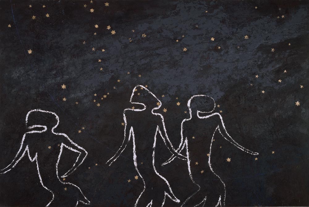
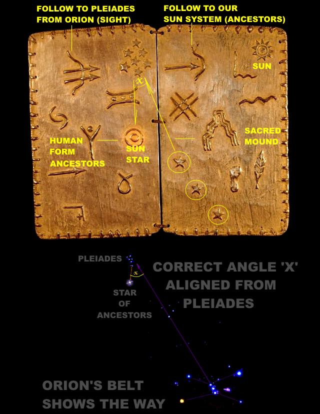
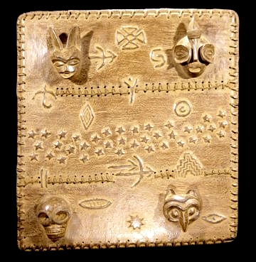
Perhaps less known but controversial is this map above by Wayne Herchel LINK TO PLEIADES this is as far as I can tell single sourced but perhaps other researchers can cast light on it's authenticity,but for now this is what he has to offer.
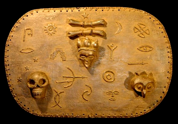
The Chokwe African tribe predominantly covering vast areas of Zambia includes an even wider territory stretching from 7 to 18 degrees latitude South and 18 to 23 degrees longitude East. Researcher and Zambian author of the book ‘Chokwe Art and its History’ - Marcus Matthe contacted Wayne in 2006 mentioning that although he had already launched his book, he has realised something very important. Marcus said that he had just noticed that the ancient star patterns on the wooden tablets in his book replicate the same star patterns in Wayne’s book. He said the African tribe of the Chokwe have preserved record of their legend of their ancestors arriving from the stars and they recorded their sacred past onto wooden tablets and bound them into pairs just like a book.
Wayne invited Marcus to see him shortly after his artefact collection went on a historical African art display overseas. The wooden tablets are probably not very ancient originals which would obviously be well over a thousand years old according to the opinion of the African elders there. This is because of the tablets religious usage in being included in ceremony and being handled a lot, especially in their circumcision ceremonies. The elders of the tribe say these tablets are constantly being replaced with duplicate carvings once a tablet cracks or becomes too worn. Some of the tablets carrying the valuable detail Wayne had recognised are perhaps only 50 to 100 years old at the most. But more importantly to Wayne, the simple fact that the actual finding date predates Wayne’s theory and book publishing date by many decades. This will sound odd to some, but scientifically speaking the simple fact that this remote tribe reproduced these tablets as copies of the earlier artefacts long before Wayne had presented the worldwide ancient repeating patterns you are about to see below. If the finding occurred after Wayne’s book was published then one could question the coincidence of the correlating patterns we see here.
The South African astronomers that tried to guide Marcus suggested their interpretation of what they thought were the closest star patterns but they sadly did not recognise the most obvious pattern match. The sacred cross of the sky seemed more appropriate to them if it included the Southern Cross. It did not fit with the Milky Way representations, the three in a row star group of Orion's Belt or the cluster of stars of the Pleiades, or the strange 'x' that marks the spot position of the star of their ancestors... all of which Wayne has found common in most ancient civilisations. After discussing the possibilities and viewing all the wooden tablets, Wayne agreed to list a few examples of the patterns that seemed quite easy to figure. Wayne proposes his views below guided by some symbol direction interpretation by Marcus who was originally instructed by an African Shaman who Marcus worked with.
The first wooden tablet below does not say much but it introduces a general star worshiping tradition. According to the shaman there is representation of the Milky way as the star belt across the centre, the sacred cross of the sky symbol at the top centre is consistent with religion. He also agreed with the stepped pyramid symbol representing burial mounds and the skull representing ‘of the spirit’ and the bird headed deity similar to Maya and Egyptian representations. Here is where Wayne begins to see more pattern matches to other ancient civilisations. In the tablet below, there are always two overlapping themes with different symbolism at play in each tablet, one more with symbols and one more with pictograms. The symbol of the circle with another circle inside it is probably representation of a sun-like star. Note how it is next to the Milky Way as our first clue to its location and that it is positioned above a pyramid burial mound symbol.
This clue has got Marcus now trying to get arial photography of the area to see if the burial mounds represent star patterns as Wayne has found in almost all ancient civilisations. Note also the bow with two arrows symbol in the lower section displays the first part of the story showing of the way to the burial mound with Sun-like star above it. It is usually followed by a second bow and arrow with one arrow to continue the story… showing the way to something in the sky.
thehiddenrecords.com...
Sit tight more to come.
edit on 14-3-2013 by Spider879 because: (no reason given)
extra DIV Interesting, i'm about to put together a thread on early Ta Seti and Naqada period archaeo-astronomy which i've been deliberating over, i see some
comparisons with regards to some of this iconography and will get back to you...
Originally posted by Kantzveldt
Interesting, i'm about to put together a thread on early Ta Seti and Naqada period archaeo-astronomy which i've been deliberating over, i see some comparisons with regards to some of this iconography and will get back to you...
Looking fwd to it really respect your knowledge of the world before the written record.
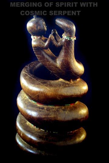
Chokwe Cosmic serpent
The above is also single sourced from the same Wayne Herschel,I posted it because it is interesting but I am in a bind as I like to triple independently source things like this before posting but if he is indeed the first then I must go along until further confirmation (grain o salt).
edit on 14-3-2013 by Spider879 because: (no reason given)
wysinger.homestead.com...
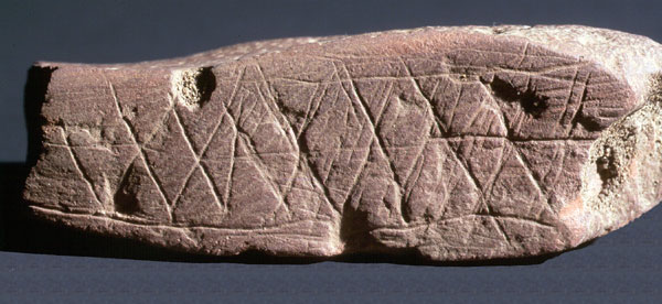
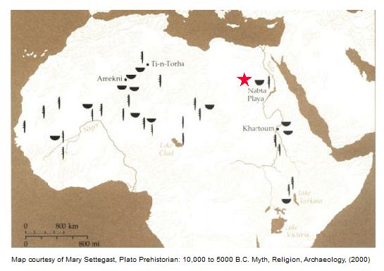
These miniature lithe while not imposing in the least a child could plant them in the sand they reveal more of the beginnings of Kemet's connection to the wet phase Sahara like nothing else it has caused researchers to drastically reconsider the origins of Kemetic civilization and that it did not developed in a vacuum,researchers like Robert Bauval and others had linked these liths to pyramid and temple constructions and star maps in a later Kemet AKA Egypt,thanks to these small stones in the sand our understanding of the origins Kemetic and Nile valley civilization has increased dramatically.
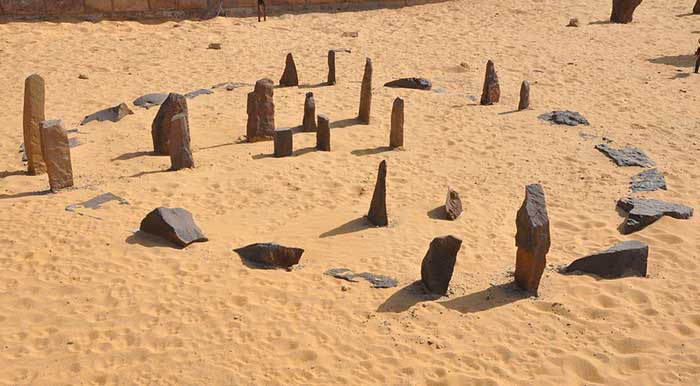
On the dusty planes of Nabta in southern Egypt, ancient nomads stopped for a short time to bask in the Nile's intense summer sunshine. Beneath the Tropic of Cancer, they erected stones that cast no shadows, aligned with the rising and setting of the sun. Location: A large basin known as Nabta Playa, located about 100 km west of Abu Simbel near the Egyptian-Sudanese border Latitude 22 32 00N. Longitude: 30 42 00E Alignments: The site, known as Nabta, is between 6,000 and 6,500 years old, or about 1,000 years older than Stonehenge. The Nabta site was discovered several years ago by a team led by Southern Methodist University anthropology Professor Fred Wendorf. It appears to have been constructed by nomadic cattle-herders living in southern Egypt. The complex isn't circular like Stonehenge. It is .8 miles wide and 1.8 miles long. It includes 10 slabs some 9 feet high, 30 rock-lined ovals, nine burial sites for cows, each under a pile of 40 to 50 rocks weighing up to 200 or 300 pounds apiece, and a "calendar circle" of stones. Many of these features line up in five radiating lines, one of them running east-west. The calendar circle is a 12-foot-wide arrangement of slabs about 18 inches long, most of them lying down. Because Nabta lies near the Tropic of Cancer, the noon sun is at its zenith about three weeks before and three weeks after the summer solstice, preventing upright objects from casting shadows. "These vertical sighting stones in the circle correspond to the zenith sun during the summer solstice," said Malville, an archeoastronomer at the University of Colorado. "For many cultures in the tropics, the zenith sun has been a major event for millennia." Two pairs of upright stones stand directly across the circle from each other, defining a view that would have displayed sunrise at the summer solstice. The circle also contains two other pairs of standing stones that defined a north-south view. webcache.googleusercontent.com...:h Read more: egyptsearchreloaded.proboards.com...
www.antiquityofman.com...
More info on Nabta Playa the site is associated with the burials of cattle a feature which will be important in kemet,A group and C group((Kush) burial sites this will link them in time and space to
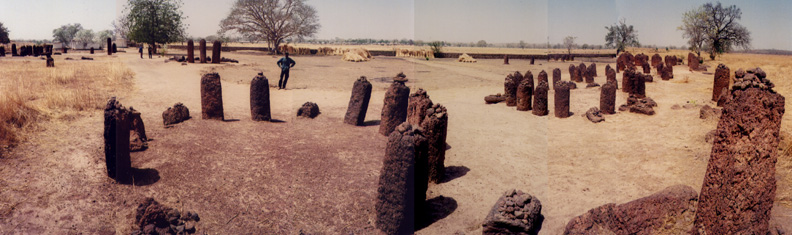
Namoratunga Kenya

Namoratunga
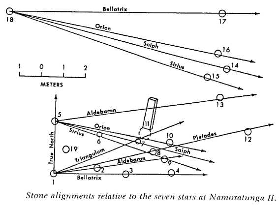
Ng'amoritung'a Kenya Namoratunga II is a site of 19 magnetic (Soper 1982, Doyle and Wilcox 1986) stone pillars cut with 4 sides and a slanted top and petroglyphs on them. Located near Lake Turkana in Kenya, Namoratunga means stone people in the local language. The site itself has not been dated, but similar petroglyphs at a burial site, Namoratunga I 100km to the south of it have caused archaeologists to give it the same date as that site - 300BC. It was discovered by B.M. Lynch and L.H Robbins in1978 and later studied by many, including L.R Doyle and Soper R. Lynch and Robbins put forth initial arguments that the pillars were astronomically aligned (Krupp, 1983 pg 170-171). Over the years the measurements and alignments of the pillars have been remeasured and reassessed. The pillars today are suggested to be aligned to the 7 stars of the Borana Calendar of the Cu#e people whose positions in the sky mark the months when they rise at the same position on the horizon with the phrases of the moon. The seven stars or star groups in order are Triangulum, Pleiades, Aldebarran, Belletrix, Orion, Saiph, and Sirius. Soper,Doyle and Edward Frank found in an 1983 expedition to the site that there were "25 two-pillar alignments with the 300 B.C. eastern rising positions of the Borana calendar stars". To prove that the alignments were not random, they generated 10,000 random star alignments, and only 0.41% of them had 25 or more random alignments. Thus it seems highly unlikely that the alignments were random. library.thinkquest.org... Read more: egyptsearchreloaded.proboards.com...
edit on 14-3-2013 by Spider879 because: (no reason given)

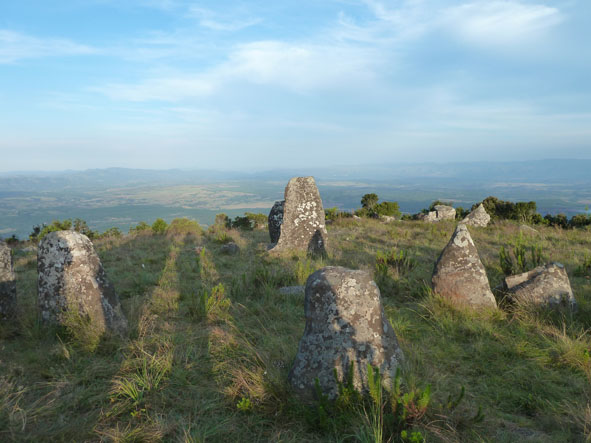
Bouar megaliths
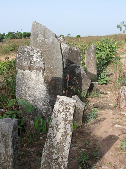
The Central African Republic, on the other hand, possesses quite spectacular megaliths in the Bouar region. This has yielded some important dates, one group lying in the lowest strata of the monuments: 7440 +/- 170 b.b, that is 5490 before our era.. we cannot be certain where the Bouar megaliths should be placed in the Neolithic period but the culture which erected them can at least be said to be contemporary with the Neolithic." --UNESCO General History of Africa: Methodology and African prehistory. 1981 "In some parts of Africa megaliths survive which are somewhat reminiscent of Stonehenge.
Hundreds of them are to be found in the borderland between Cameroon and Central African Republic. They are thought to be memorials, but contain no human remains, and were made by cultivators during the first millennium BCE. That they had the energy and resources to cut, transport and erect stones so large that they posed a danger to modern excavators shows the strength the religious or other beliefs which inspired them. It also reflects a culture which could afford this type of extravagance" Elizabeth Allo Isichei - 1997. A History of African Societies to 1870
Stay tuned more to come
Wassu Stone Circles Senegal
Between Wassau and Kau-Ur lay the mysterious Stone Circles. These circles to this day remain an anthropological and archeologically puzzle. Experts think that the stone circles are the only remaining evidence of an old unknown African civilisation. The circles remind us a bit of Stonehenge in Scotland, but it is not certain if these circles are in line with the solar circulation. No archaeological excavations have been made because the Village Chiefs think a curse will descent on everybody if the holy circles are disturbed
www.lamininthegambia.com...
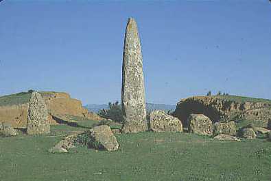
Moroccan Megalithic Menhirs of Mzora
The Mysterious Moroccan Megalithic Menhirs of Mzora In Morocco, not far from the Atlantic coast and away from major tourist attractions, lies a remarkable and enigmatic megalithic site. The Mzora stone ring (also spelled variously as Msoura/Mezorah) is situated roughly 11km from the nearest town of Asilah and about 27km from the ruins of ancient Lixus. It is not easy to reach and a small display in the archaeological museum at Tetouan is the most the majority of visitors see or hear of this very interesting site.
Plutarch, in the first century CE, may have referred to Mzora in his Life of Sertorius. He describes the Roman General Quintus Sertorius being told by local inhabitants about a site they knew as the tomb of the giant Antaeus who had been killed by Hercules. There are many other ancient accounts that place the tomb of Antaeus in close proximity to both Lixus and Tangier and it is quite plausible that Mzora is the inspiration behind these stories. The site itself is a Neolithic ellipse of 168 surviving stones of the 175 originally believed to have existed. The tallest of these stones is over 5m in height. The ellipse has a major axis of 59.29 metres and a minor axis of 56.18 metres. At the centre of the ring, and quite probably a much later addition, is a large tumulus, today almost disappeared. The bulk of the damage to it seems to have been done by excavations undertaken in 1935-6 by César Luis de Montalban. The only professional survey of the site was conducted in the 1970s by James Watt Mavor, Junior of the Woods Hole Oceanographic Institute in Massachusetts, USA.
It is this survey that revealed Mzora to be not only remarkable in its own right but to have implications for the history of megalithic sites in Britain. Mzora, incredibly, appears to have been constructed either by the same culture that erected the megalithic sites in France, Britain and Ireland or by one that was intimately connected with them. The ellipse is constructed using a Pythagorean right angled triangle of the ratio 12, 35, 37.
This same technique was used in the construction of British stone ellipses of which 30 good examples survive including the Sands of Forvie and Daviot rings. Furthermore it appears that the same unit of measure, the megalithic yard (or something remarkably close) used in the construction of the British sites surveyed by Professor Alexander Thom, was also used in the construction of Mzora. "If a 'megalithic yard' of 0.836 metres ... [is used] ... then the major axis and the perimeter of the ring take on values nearly integral," Robert Temple - visiting Professor of the History and Philosophy of Science at Tsinghua University in Beijing - wrote in his 'Egyptian Dawn' book. Thom proposed that achieving a circumference measured in whole numbers was of paramount importance to the builders of megalithic rings. But there is more: according to studies by James Watt Mavor, at least seven stones of the Mzora circle mark different astronomical phenomena: winter and sumer solstice sunrises/sunsets, equinoctial sunrises and sunsets. Mzora isn't the only stone circle in Africa to share its construction methodology with British sites. The Nabta Playa stone ring in Southern Egypt conforms to Alexander Thom's 'Type I egg' geometry. But at present Mzora is unmanaged, exposed and vulnerable, so this monument surely deserves better protection and further study. www.stonepages.com...
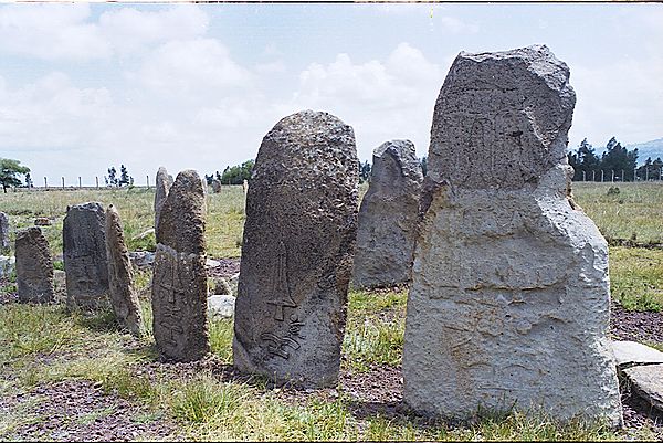
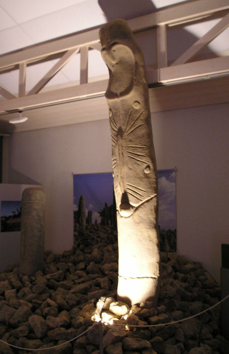
Ethiopian Menhirs
Don't they kind of remind you of GobekliTepe thousands of years earlier?
Ethiopian carved megalith reconstruction. When I visited the wonderful CAIRN Museum, St Hilaire-la-Foret, Vendée, France, there was a fabulous exhibition of megaliths recently discovered in Ethiopia. The similarity between this, and the Statue Menhirs found in southern France is immediately apparent, which makes you realise how similar people from all over the world are.
www.megalithic.co.uk...
new topics
-
President BIDEN Vows to Make Americans Pay More Federal Taxes in 2025 - Political Suicide.
2024 Elections: 1 hours ago -
Ode to Artemis
General Chit Chat: 2 hours ago -
Ditching physical money
History: 5 hours ago -
One Flame Throwing Robot Dog for Christmas Please!
Weaponry: 6 hours ago -
Don't take advantage of people just because it seems easy it will backfire
Rant: 6 hours ago -
VirginOfGrand says hello
Introductions: 7 hours ago -
Should Biden Replace Harris With AOC On the 2024 Democrat Ticket?
2024 Elections: 7 hours ago -
University student disciplined after saying veganism is wrong and gender fluidity is stupid
Education and Media: 10 hours ago -
Geddy Lee in Conversation with Alex Lifeson - My Effin’ Life
People: 11 hours ago -
God lived as a Devil Dog.
Short Stories: 11 hours ago
top topics
-
Hate makes for strange bedfellows
US Political Madness: 16 hours ago, 20 flags -
University student disciplined after saying veganism is wrong and gender fluidity is stupid
Education and Media: 10 hours ago, 12 flags -
Police clash with St George’s Day protesters at central London rally
Social Issues and Civil Unrest: 13 hours ago, 9 flags -
President BIDEN Vows to Make Americans Pay More Federal Taxes in 2025 - Political Suicide.
2024 Elections: 1 hours ago, 7 flags -
TLDR post about ATS and why I love it and hope we all stay together somewhere
General Chit Chat: 14 hours ago, 7 flags -
Should Biden Replace Harris With AOC On the 2024 Democrat Ticket?
2024 Elections: 7 hours ago, 6 flags -
Don't take advantage of people just because it seems easy it will backfire
Rant: 6 hours ago, 4 flags -
One Flame Throwing Robot Dog for Christmas Please!
Weaponry: 6 hours ago, 4 flags -
God lived as a Devil Dog.
Short Stories: 11 hours ago, 3 flags -
Ditching physical money
History: 5 hours ago, 3 flags
active topics
-
Why to avoid TikTok
Education and Media • 17 • : mooncake -
The Superstition of Full Moons Filling Hospitals Turns Out To Be True!
Medical Issues & Conspiracies • 22 • : mooncake -
University student disciplined after saying veganism is wrong and gender fluidity is stupid
Education and Media • 23 • : BigDuckEnergy -
President BIDEN Vows to Make Americans Pay More Federal Taxes in 2025 - Political Suicide.
2024 Elections • 3 • : BingoMcGoof -
Russia Ukraine Update Thread - part 3
World War Three • 5717 • : Arbitrageur -
Should Biden Replace Harris With AOC On the 2024 Democrat Ticket?
2024 Elections • 44 • : budzprime69 -
Hundreds of teenagers flood into downtown Chicago, smashing car windows
Other Current Events • 111 • : 777Vader -
British TV Presenter Refuses To Use Guest's Preferred Pronouns
Education and Media • 125 • : Annee -
Who guards the guards
US Political Madness • 4 • : kwaka -
New whistleblower Jason Sands speaks on Twitter Spaces last night.
Aliens and UFOs • 44 • : pianopraze
15