It looks like you're using an Ad Blocker.
Please white-list or disable AboveTopSecret.com in your ad-blocking tool.
Thank you.
Some features of ATS will be disabled while you continue to use an ad-blocker.

Quake Watch 2013
page: 193share:
reply to post by PuterMan
I find your 52-week rolling charts most useful. Any speculation on where or how large the earthquakes will be when this period of quiescence ends?
I find your 52-week rolling charts most useful. Any speculation on where or how large the earthquakes will be when this period of quiescence ends?
Not posted yet, but there's been a 4+M somewhere around Oklahoma/Texas/Arkansas. Most likely OK. Will post more info as soon as the USGS figures it
out.
While I wait, I have been watching Etna and her siemos. It's not wind this time as it was corresponding to the eruption. Awesome stuff. The tremor seems to be ebbing away now.
Oh Lordy, I'm off by a little bit. North. KANSAS???? 4.2M
earthquake.usgs.gov...
I shouldn't be surprised. It's on the Kansas Oklahoma border. And you can find wells and drilling on the Kansas side.
Looks like that big ole crack runs all the way from Texas to Southern Kansas.
Yup, Wells within 2Km. Maybe less if satellite map pictures are old.
edit on 16-12-2013 by ericblair4891 because: (no reason given)
reply to post by ericblair4891
Dang! How often does that area have quakes? Lawd... I am off to search for more answers. Thanks for the link.
Is it just me or does anyone notice fracking quakes come in at depths of 5? Its me isnt it? lol
Dang! How often does that area have quakes? Lawd... I am off to search for more answers. Thanks for the link.
Is it just me or does anyone notice fracking quakes come in at depths of 5? Its me isnt it? lol
edit on 16-12-2013 by MamaJ because: (no
reason given)
MamaJ
reply to post by ericblair4891
Dang! How often does that area have quakes? Lawd... I am off to search for more answers. Thanks for the link.
Is it just me or does anyone notice fracking quakes come in at depths of 5? Its me isnt it? loledit on 16-12-2013 by MamaJ because: (no reason given)
Here are all the posted quakes in Kansas since 1973....notta many!!
earthquake.usgs.gov...
edit on 16-12-2013 by radpetey because: (no reason given)
reply to post by radpetey
Thank you for that. Yeah not many and the depth is minimal as well. HMMMM?
Fracking quake perhaps? Hopefully nothing bigger comes our way. Im in TN so anything much bigger could possibly be felt here.
Thank you for that. Yeah not many and the depth is minimal as well. HMMMM?
Fracking quake perhaps? Hopefully nothing bigger comes our way. Im in TN so anything much bigger could possibly be felt here.
MamaJ
reply to post by radpetey
Thank you for that. Yeah not many and the depth is minimal as well. HMMMM?
Fracking quake perhaps? Hopefully nothing bigger comes our way. Im in TN so anything much bigger could possibly be felt here.
I am right down the street from you(memphis...eeewwww), so I often echo your concerns about living in this area
One of these days it could get very ugly!
reply to post by radpetey
Yep, so true!
There has yet to be ANY "I felt it reports" via earthquake-report.com...
I find that odd... considering the mag and depth.
This is an interesting read. I wonder which fault is... at fault?
Also, here is an article that excludes fracking in the area? There was a 2.8 that happened in September near this location. Maybe these are foreshocks? I have NO IDEA... just talking/typing aloud. sciencythoughts.blogspot.com...
Yep, so true!
There has yet to be ANY "I felt it reports" via earthquake-report.com...
I find that odd... considering the mag and depth.
This is an interesting read. I wonder which fault is... at fault?
On April 24, 1867, the 1867 Manhattan earthquake struck Riley County, Kansas. Measuring 5.1 on the Richter scale, the earthquake's epicenter was by the town of Manhattan, to this day, the strongest earthquake to originate in the state.
The earthquake had an intensity of VII on the Mercalli intensity scale, and was felt over an area of roughly 193,051 square miles (500,000 km2). It caused largely minor damage, reports of which were confined to Kansas, Iowa, and Missouri, according to the United States Geological Survey.
Manhattan is near the Nemaha Ridge, a long structure that is bounded by several faults. The nearby Humboldt Fault Zone in particular poses a threat to the city; though Kansas is not known for earthquake activity, an earthquake could occur at any time.
en.wikipedia.org...
Despite the fact that Kansas is not seismically active, a strong earthquake could pose significant threats to the state. If an earthquake were to occur, it would likely be along the Nemaha Ridge, which is still active.[8] The Humboldt Fault Zone, a fault just off the Ridge, lies just 12 miles (19 km) eastward of the Tuttle Creek Reservoir near Manhattan. If an earthquake were to occur here, it would likely destroy the dam, releasing 300,000 feet (91,440 m) of water per second and flooding the nearby area, also threatening roughly 13,000 people and 5,900 homes. A moderate earthquake "between 5.7 to 6.6 would cause sand underneath the dam to liquefy into quicksand, causing the dam to spread out and the top to drop up to three feet."[2] A large earthquake would spawn gaps, forcing water to leak and eventually cause the dam to collapse. Any earthquake that could pose a threat occurs on a cycle of roughly 1,800 years, according to the United States Army Corps of Engineers, who studied the area first in 1980.[2]
To counter this threat, the group has galvanized an effort to strengthen the dam. Replacing the sand, which could shift during an earthquake, with more than 350 walls, the group has equipped the dam with sensors. Alarms are connected to these sensors, which would alert nearby citizens to the earthquake.[2]
Also, here is an article that excludes fracking in the area? There was a 2.8 that happened in September near this location. Maybe these are foreshocks? I have NO IDEA... just talking/typing aloud. sciencythoughts.blogspot.com...
edit on 16-12-2013 by MamaJ because: (no reason
given)
4 hrs ago.
Thank goodness, this Topic was in danger of turning into a Fracking Topic, which it is not.!
170 felt reports, isolated area, early morning
other networks range from 5.6 to 5.7 depending on the magnitude type
a few aftershocks
(click image for interactive map,
opens in new tab/window)
NZ energy count graph was right again, on the 14th ER was below 10 (at 8)
Has been quiet right through December here, no 5's since 18th November!
Last M6 was 11thOct at the Kermadecs
Last M6 close in was the Cook Strait 6.5 on August 16th
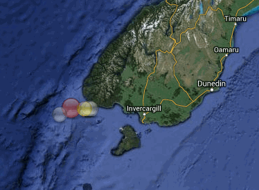
NZ 2013 M5+ map
Thank goodness, this Topic was in danger of turning into a Fracking Topic, which it is not.!
Public ID 2013p944608
Universal Time December 16 2013 at 12:07:26
NZ Daylight Time Tuesday, December 17 2013 at 1:07:26 am
Latitude, Longitude -46.28, 166.04
Intensity ? severe
Focal Depth 25 km
Magnitude 6.2 ML
Location offshore 125 km west of Tuatapere (Puysegur Bank)
www.geonet.org.nz...
170 felt reports, isolated area, early morning
other networks range from 5.6 to 5.7 depending on the magnitude type
a few aftershocks
(click image for interactive map,
opens in new tab/window)
NZ energy count graph was right again, on the 14th ER was below 10 (at 8)
Has been quiet right through December here, no 5's since 18th November!
Last M6 was 11thOct at the Kermadecs
Last M6 close in was the Cook Strait 6.5 on August 16th
NZ 2013 M5+ map
edit on 1200000034934913 by muzzy because: (no reason given)
reply to post by muzzy
How about this one? Larger than what i have seen in this area recently.
USGS
How about this one? Larger than what i have seen in this area recently.
M4.2 - 18km WNW of Caldwell, Kansas
2013-12-16 15:09:53 UTC
Event Time
2013-12-16 15:09:53 UTC
2013-12-16 09:09:53 UTC-06:00 at epicenter
2013-12-16 09:09:53 UTC-06:00 system time
Location
37.124°N 97.781°W depth=5.0km (3.1mi)
Nearby Cities
18km (11mi) WNW of Caldwell, Kansas
61km (38mi) SW of Haysville, Kansas
65km (40mi) SW of Derby, Kansas
66km (41mi) W of Arkansas City, Kansas
185km (115mi) N of Oklahoma City, Oklahoma
USGS
reply to post by Olivine
High 7 low 8 in Vanuatu/Santa Cruz
So it probably won't be just to prove me wrong!
High 7 low 8 in Vanuatu/Santa Cruz
So it probably won't be just to prove me wrong!
reply to post by PuterMan
Hey, PuterMan & Muzzy . . .
The green cluster of quakes in the below 3D
www.iris.edu... bl=1&zm=5&mt=ter&sz=med
seem to be MOSTLY on the East side of the fault line . . .
And the quakes closer to the surface seem to be mostly on the Western side of the fault line.
Might you "lay experts" be able to make some conjectures, inferences therefrom?
I've forgotten how to get the pic to post. I have the step by step printed out somewhere. LOL.
Sorry.
reply to post by BO XIAN
subduction, west under east, (Australian under Pacific Plate, or Pacific over Australian depending on which way you look)
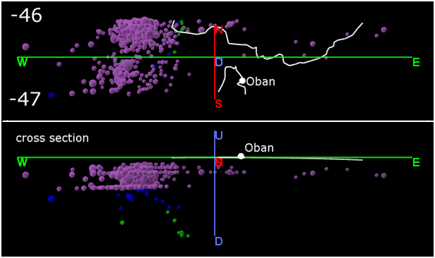
the next latitude above that one (-45.5) is even more of a pronounced "dive"
NZ cross Sections
I think this 6.2 is related to the 2009 M7.8 at Dusky Sound, may be along time after but there have been very few aftershocks from this particular event. The main bulk of the Dusky Sound aftershocks were north of this area.
that last linked page needs updating to i-frames, but I'm busy animating the cook strait 6's by the hour.
subduction, west under east, (Australian under Pacific Plate, or Pacific over Australian depending on which way you look)
the next latitude above that one (-45.5) is even more of a pronounced "dive"
NZ cross Sections
edit on 1200000035035013 by muzzy because: (no reason given)
I think this 6.2 is related to the 2009 M7.8 at Dusky Sound, may be along time after but there have been very few aftershocks from this particular event. The main bulk of the Dusky Sound aftershocks were north of this area.
edit on 12u35035013 by muzzy because: (no reason given)
that last linked page needs updating to i-frames, but I'm busy animating the cook strait 6's by the hour.
edit on 1200000035035013 by muzzy
because: (no reason given)
reply to post by muzzy
THX THX.
And if one doesn't buy into the subduction theory . . . what is the explanation?
NZ sure has . . . interesting . . . geology.
LOL.
I assume you keep your seat belt buckled!
THX THX.
And if one doesn't buy into the subduction theory . . . what is the explanation?
NZ sure has . . . interesting . . . geology.
LOL.
I assume you keep your seat belt buckled!
I think the 16+ day streak of no mag 6 quakes has come to an end via the Marianas Islands region:
GFZ --Mag 6.2
USGS --Mag 5.8 (much too low in my opinion, after looking at the waveforms)
GFZ --Mag 6.2
USGS --Mag 5.8 (much too low in my opinion, after looking at the waveforms)
edit on 12/17/2013 by Olivine because: reworking
edit on 12/17/2013 by Olivine because: fixing wonky linkage
reply to post by Olivine
LDEO have;
2013 12 17 23 38 16.0 21.00 147.00 33.0 6.4MS MARIANA ISLANDS REGION
LDEO have;
2013 12 17 23 38 16.0 21.00 147.00 33.0 6.4MS MARIANA ISLANDS REGION
BO XIAN
reply to post by muzzy
THX THX.
And if one doesn't buy into the subduction theory . . . what is the explanation?
NZ sure has . . . interesting . . . geology.
LOL.
I assume you keep your seat belt buckled!
yes indeed and always ready to survive the first week on our own while the place is in a shambles.
If its not subduction then there is a big crack between the plates at a 45 degree angle going down from west to east.
I noticed the Balleny Is quakes on LDEO on the 15th but hadn't looked again until the 16th and the Puysegur Bank 6.2, but put these 3 below together and the odds of a NZ SI quake did seem to be on the cards, Fiordland has been pretty quiet since the Cook Strait July/Aug quakes, like the movement there stablized things a bit. I wonder if this latest one brings more stress back on the lower SI or is reaction to Cook Straits?
2013 12 16 4 11 44.0 -59.00 149.00 33.0 5.6 WEST OF MACQUARIE ISLAND
2013 12 15 8 54 0.0 -61.75 153.75 33.0 4.9 BALLENY ISLANDS REGION
2013 12 15 5 46 0.0 -61.25 153.75 33.0 4.9 BALLENY ISLANDS REGION
edit on 12u35035013 by muzzy because: (no reason given)
reply to post by muzzy
Interesting points and perceptive observations, as usual.
THX.
Is South Island normally considered more stable than North Island . . . errrr perhaps until the Christchurch quakes? LOL.
Maybe I'm not paying enough attention. I know South Island has a lot of quakes. It just seems, stuck in my mind somehow, that North Island with the volcanoes etc. would have more quakes but I certainly haven't been counting them. LOL.
I wonder which side of NZ the purported "new land" is supposed to arise off of.
reply to post by muzzy
Which is probably about all we can say as there are many reasons why the 'crack' in the WBZ may exist including spherical lensing as well as many reasons why subduction cannot work as promoted if EMST is to be believed.
Very difficult to find any references for this as it is somewhat obscure!
If its not subduction then there is a big crack between the plates at a 45 degree angle going down from west to east.
Which is probably about all we can say as there are many reasons why the 'crack' in the WBZ may exist including spherical lensing as well as many reasons why subduction cannot work as promoted if EMST is to be believed.
Very difficult to find any references for this as it is somewhat obscure!
Whoa!
What did I see when I opened the quake page today?
A string of quakes along the far side of the 'ring'.
But the thing that really said, "Look at me!",
was the glaring nakedness of the U.S.!
The 2.5 & above map, only has a couple of little zits in Alaska.
Everything else is so bare!
Is something holding it's breath?
All the energy is mostly being released on one side.
I hope it's not going to be like a rubber band snapping back!
WOQ
Can't get the link to work!?
USGS I day, mag 2.5+ worldwide.
edit on 18-12-2013 by wasobservingquietly because: (no reason given)
edit on 18-12-2013 by wasobservingquietly because: (no
reason given)
edit on 18-12-2013 by wasobservingquietly because: (no reason given)
edit on 18-12-2013 by
wasobservingquietly because: (no reason given)
reply to post by wasobservingquietly
thats what happens when you don't watch over at your neighbours, some action at Jaun Fuca Plate today
Canada's got a handle on it even if USGS hasn't
goo.gl...
thats what happens when you don't watch over at your neighbours, some action at Jaun Fuca Plate today
Canada's got a handle on it even if USGS hasn't
goo.gl...
new topics
-
The Baloney aka BS Detection Kit
Social Issues and Civil Unrest: 3 hours ago -
Suspected Iranian agent working for Pentagon while U.S. coordinated defense of Israel
US Political Madness: 3 hours ago -
How does my computer know
Education and Media: 6 hours ago -
USO 10 miles west of caladesi island, Clearwater beach Florida
Aliens and UFOs: 10 hours ago
top topics
-
USO 10 miles west of caladesi island, Clearwater beach Florida
Aliens and UFOs: 10 hours ago, 8 flags -
Suspected Iranian agent working for Pentagon while U.S. coordinated defense of Israel
US Political Madness: 3 hours ago, 5 flags -
How does my computer know
Education and Media: 6 hours ago, 2 flags -
The Baloney aka BS Detection Kit
Social Issues and Civil Unrest: 3 hours ago, 1 flags
active topics
-
Candidate TRUMP Now Has Crazy Judge JUAN MERCHAN After Him - The Stormy Daniels Hush-Money Case.
Political Conspiracies • 191 • : SchrodingersRat -
Running Through Idiot Protestors Who Block The Road
Rant • 47 • : stu119 -
Suspected Iranian agent working for Pentagon while U.S. coordinated defense of Israel
US Political Madness • 5 • : ImagoDei -
Afterlife, unknown, so prepare, or just go into the unknown (bad)!!
ATS Skunk Works • 51 • : Kennyb75 -
It has begun... Iran begins attack on Israel, launches tons of drones towards the country
World War Three • 628 • : Lazy88 -
Mandela Effect - It Happened to Me!
The Gray Area • 99 • : ArMaP -
America's Infant Mortality Rate Increases for the First Time in 20 Years
Medical Issues & Conspiracies • 18 • : Kurokage -
OUT OF THE BLUE Chilling moment pulsating blue cigar-shaped UFO is filmed hovering over PHX AZ
Aliens and UFOs • 38 • : ArMaP -
How does my computer know
Education and Media • 9 • : BernnieJGato -
-@TH3WH17ERABB17- -Q- ---TIME TO SHOW THE WORLD--- -Part- --44--
Dissecting Disinformation • 474 • : McTech2