It looks like you're using an Ad Blocker.
Please white-list or disable AboveTopSecret.com in your ad-blocking tool.
Thank you.
Some features of ATS will be disabled while you continue to use an ad-blocker.

Quake Watch 2013
page: 192share:
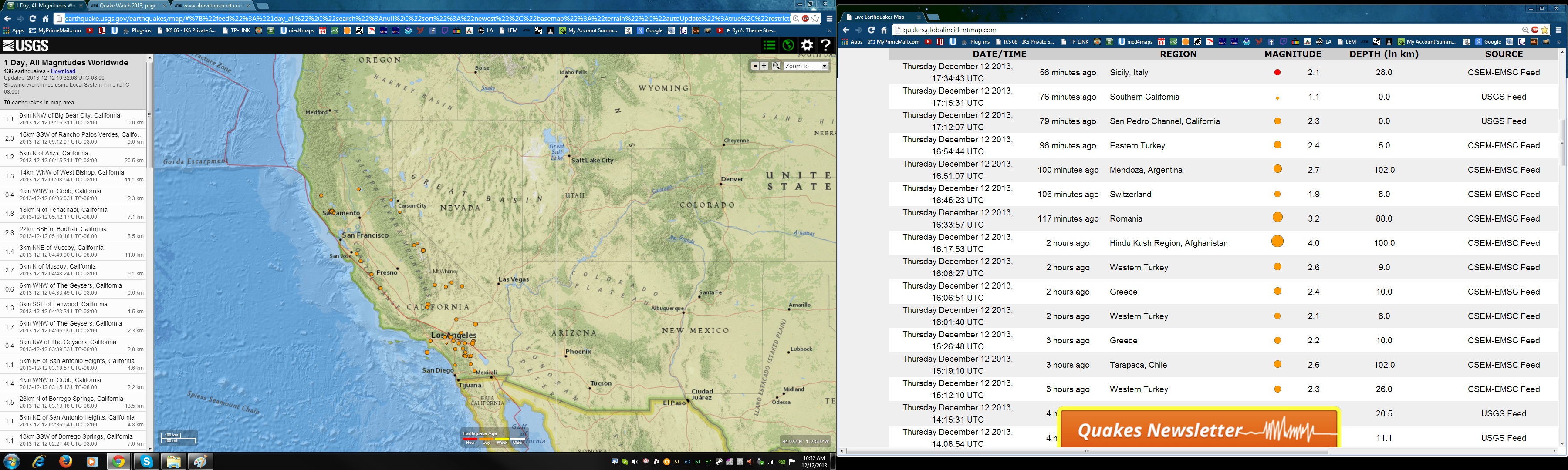
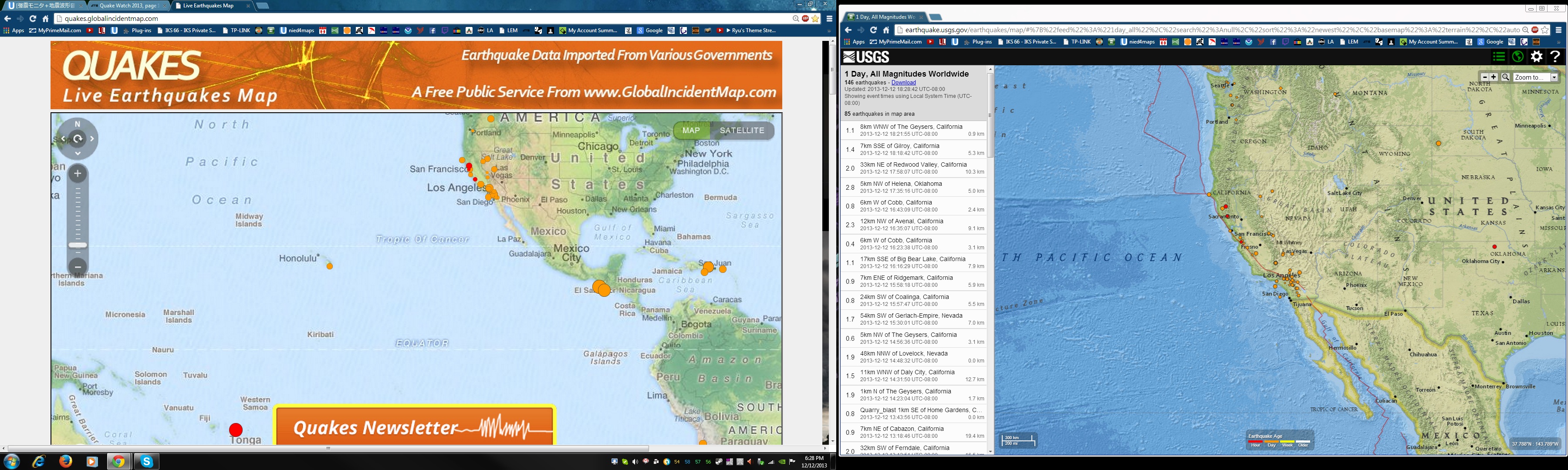
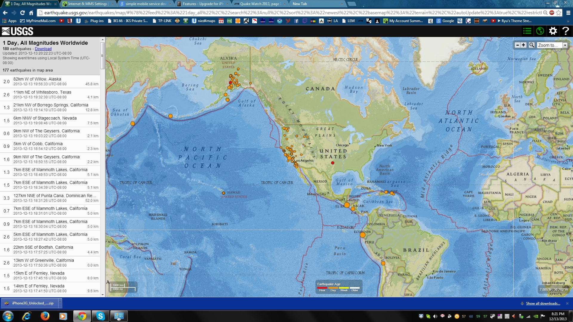
What is happening on the west coast?
dreamfox1
Im putting it out there. Im nervous tonight. (Pacific time)
Some part of the west coast of North America may get from a 7 or 9+ Mag quake by later this evening or by tomorrow morning.
I see too much activity tonight and all day long watching it.
I hope nothing happens and i am wrong but i would feel worse if i didn't let others know how i feel.edit on 7/30/2012 by dreamfox1 because: (no reason given)edit on 7/30/2012 by dreamfox1 because: (no reason given)
reply to post by AlexanderM
So far its been more focused on the south of California near Los Angeles were i live.
1.1
9km NNW of Big Bear City, California
2013-12-12 09:15:31 UTC-08:000.0 km
2.3
16km SSW of Rancho Palos Verdes, California
2013-12-12 09:12:07 UTC-08:000.0 km
0.9
25km ESE of Eatonville, Washington
2013-12-12 06:27:03 UTC-08:0014.3 km
1.2
5km N of Anza, California
2013-12-12 06:15:31 UTC-08:0020.5 km
1.3
14km WNW of West Bishop, California
2013-12-12 06:08:54 UTC-08:0011.1 km
0.4
4km WNW of Cobb, California
2013-12-12 06:06:03 UTC-08:002.3 km
1.8
18km N of Tehachapi, California
2013-12-12 05:42:17 UTC-08:007.1 km
2.8
22km SSE of Bodfish, California
2013-12-12 05:40:18 UTC-08:008.5 km
1.4
3km NNE of Muscoy, California
2013-12-12 04:49:00 UTC-08:0011.0 km
2.7
3km N of Muscoy, California
2013-12-12 04:48:24 UTC-08:009.1 km
0.6
6km WNW of The Geysers, California
2013-12-12 04:33:49 UTC-08:000.6 km
1.3
3km SSE of Lenwood, California
2013-12-12 04:23:31 UTC-08:001.5 km
1.7
6km WNW of The Geysers, California
2013-12-12 04:05:55 UTC-08:002.3 km
0.4
8km NW of The Geysers, California
2013-12-12 03:39:33 UTC-08:002.8 km
1.1
5km NE of San Antonio Heights, California
2013-12-12 03:18:57 UTC-08:004.6 km
1.4
4km WNW of Cobb, California
2013-12-12 03:15:13 UTC-08:002.2 km
1.5
23km N of Borrego Springs, California
2013-12-12 03:13:18 UTC-08:0013.5 km
1.1
5km NE of San Antonio Heights, California
2013-12-12 02:36:54 UTC-08:004.8 km
1.1
13km SSW of Borrego Springs, California
2013-12-12 02:21:40 UTC-08:007.0 km
0.8
3km ESE of The Geysers, California
2013-12-12 01:57:45 UTC-08:003.9 km
1.0
15km E of Seven Trees, California
2013-12-12 01:56:20 UTC-08:005.9 km
0.6
7km NW of The Geysers, California
2013-12-12 01:54:25 UTC-08:002.9 km
2.0
6km N of Sky Valley, California
2013-12-12 01:03:01 UTC-08:006.4 km
1.9
6km ESE of Willits, California
2013-12-12 00:41:29 UTC-08:009.6 km
0.9
7km NW of The Geysers, California
2013-12-12 00:33:18 UTC-08:002.8 km
1.5
8km ENE of Gilroy, California
2013-12-12 00:25:52 UTC-08:008.5 km
0.6
9km NW of The Geysers, California
2013-12-11 23:23:57 UTC-08:001.9 km
0.8
12km SSE of Gardnerville Ranchos, Nevada
2013-12-11 23:02:00 UTC-08:006.0 km
0.5
13km N of Seabeck, Washington
2013-12-11 22:41:01 UTC-08:0019.8 km
1.0
1km SE of Menifee, California
2013-12-11 22:05:59 UTC-08:009.1 km
0.9
7km WNW of The Geysers, California
2013-12-11 22:03:04 UTC-08:002.8 km
0.4
8km WNW of The Geysers, California
2013-12-11 22:02:06 UTC-08:005.5 km
0.5
3km W of Cobb, California
2013-12-11 21:59:53 UTC-08:001.5 km
1.4
3km SW of Los Angeles, California
2013-12-11 21:28:29 UTC-08:007.4 km
0.5
27km SSW of Morton, Washington
2013-12-11 21:27:16 UTC-08:0015.0 km
1.2
7km SSW of Mammoth Lakes, California
2013-12-11 21:26:50 UTC-08:005.3 km
0.3
22km W of Belfair, Washington
2013-12-11 21:15:18 UTC-08:004.1 km
1.1
4km W of Idyllwild-Pine Cove, California
2013-12-11 21:13:37 UTC-08:0021.6 km
1.3
12km S of Anza, California
2013-12-11 21:11:17 UTC-08:0011.5 km
0.2
28km S of Morton, Washington
2013-12-11 20:52:54 UTC-08:0015.9 km
1.1
8km ESE of Yelm, Washington
2013-12-11 20:42:33 UTC-08:0020.5 km
1.3
0km N of Beaumont, California
2013-12-11 20:33:02 UTC-08:0014.7 km
1.5
33km ENE of Soledad, California
2013-12-11 20:20:10 UTC-08:0024.1 km
0.3
12km NNW of Seabeck, Washington
2013-12-11 19:45:22 UTC-08:0018.6 km
1.8
28km SSW of Morton, Washington
2013-12-11 19:22:22 UTC-08:0014.3 km
1.5
62km NE of Searles Valley, California
2013-12-11 19:06:45 UTC-08:008.0 km
2.2
59km N of Joshua Tree, California
2013-12-11 19:06:23 UTC-08:004.1 km
1.3
25km ENE of Pine Valley, California
2013-12-11 18:56:50 UTC-08:006.9 km
1.1
19km ESE of Anza, California
2013-12-11 18:39:35 UTC-08:0014.8 km
1.2
50km N of Searles Valley, California
2013-12-11 18:32:50 UTC-08:0012.0 km
0.7
10km WNW of Cobb, California
2013-12-11 18:32:44 UTC-08:002.2 km
1.8
1km SW of Cobb, California
2013-12-11 17:50:59 UTC-08:003.0 km
1.1
37km NNW of Searles Valley, California
2013-12-11 17:21:28 UTC-08:001.1 km
0.4
6km NW of The Geysers, California
2013-12-11 17:19:07 UTC-08:003.2 km
0.3
3km SSE of Morton, Washington
2013-12-11 16:48:10 UTC-08:005.0 km
1.7
45km S of Lone Pine, California
2013-12-11 16:40:16 UTC-08:003.4 km
1.1
23km SW of Coalinga, California
2013-12-11 16:26:21 UTC-08:003.3 km
1.0
4km WNW of The Geysers, California
2013-12-11 16:23:56 UTC-08:001.3 km
1.7
3km ENE of Gold Bar, Washington
2013-12-11 16:19:16 UTC-08:0010.4 km
-0.4
32km S of Morton, Washington
2013-12-11 16:02:46 UTC-08:002.4 km
1.0
Quarry_blast 2km NE of Norco, California
2013-12-11 16:01:44 UTC-08:000.0 km
1.0
1km NNW of The Geysers, California
2013-12-11 15:38:36 UTC-08:002.1 km
0.8
10km ENE of Aguanga, California
2013-12-11 15:34:46 UTC-08:006.7 km
0.3
28km SSW of Morton, Washington
2013-12-11 15:28:09 UTC-08:0016.1 km
2.1
27km SSW of Morton, Washington
2013-12-11 15:09:25 UTC-08:0014.3 km
1.6
12km S of Joshua Tree, California
2013-12-11 14:46:48 UTC-08:009.2 km
2.8
17km S of Ucluelet, Canada
2013-12-11 14:40:44 UTC-08:0028.8 km
1.8
Quarry Blast 8km SW of Connell, Washington
2013-12-11 14:39:00 UTC-08:000.0 km
2.3
14km WNW of West Bishop, California
2013-12-11 14:26:35 UTC-08:0012.6 km
0.6
6km NW of The Geysers, California
2013-12-11 14:16:36 UTC-08:003.1 km
1.6
11km ENE of Cloverdale, California
2013-12-11 13:51:17 UTC-08:001.6 km
0.4
3km SSW of Tahoe Vista, California
2013-12-11 13:48:49 UTC-08:0011.7 km
0.6
2km NE of The Geysers, California
2013-12-11 13:33:32 UTC-08:002.1 km
0.6
6km NW of The Geysers, California
2013-12-11 13:00:46 UTC-08:003.4 km
1.0
Quarry_blast 3km W of Escondido, California
2013-12-11 12:41:24 UTC-08:000.0 km
2.3
Quarry Blast 9km NNW of Oroville, California
2013-12-11 12:40:00 UTC-08:000.0 km
2.1
28km W of Polson, Montana
2013-12-11 12:28:03 UTC-08:005.2 km
1.1
7km WNW of Cobb, California
2013-12-11 12:25:05 UTC-08:002.6 km
0.6
4km NE of San Antonio Heights, California
2013-12-11 12:17:28 UTC-08:003.0 km
0.5
9km ENE of Mammoth Lakes, California
2013-12-11 12:15:58 UTC-08:006.0 km
1.8
11km S of Joshua Tree, California
2013-12-11 12:15:55 UTC-08:008.1 km
0.6
10km ENE of Mammoth Lakes, California
2013-12-11 12:10:18 UTC-08:004.8 km
1.2
3km ESE of Loma Linda, California
2013-12-11 11:20:02 UTC-08:0016.7 km
1.1
9km ENE of Cabazon, California
2013-12-11 10:50:30 UTC-08:0015.5 km
0.5
4km NW of The Geysers, California
2013-12-11 10:44:51 UTC-08:003.6 km
files.abovetopsecret.com...
files.abovetopsecret.com...
files.abovetopsecret.com...
edit on 7/30/2012 by dreamfox1 because: (no reason given)
Just off the phone with my mom who lives in the Black Hills area in SW South Dakota. Said she heard on the news this morning of an earthquake.
I went and looked it up, and sure enough:
M3.5 - 16km ENE of Custer, South Dakota
2013-12-12 09:43:20 UTC
USGS source
Is this an off-shoot of the frequent (small) Yellowstone quakes? Or just a one-time fluke?
I went and looked it up, and sure enough:
M3.5 - 16km ENE of Custer, South Dakota
2013-12-12 09:43:20 UTC
USGS source
Is this an off-shoot of the frequent (small) Yellowstone quakes? Or just a one-time fluke?
reply to post by kalunom
I have been a quaker for two years now, and never remember seeing one in S. Dakota!
Here's a link for only two notables...the other lists for quakes in that area are not working
earthquake.usgs.gov...
A little, more comprehensive update on the quake list for this area....It is also highly unlikely that this is in any way related to Yellowstone.
earthquaketrack.com...
However, the DOOM side of me would love it to be so
edit on 12-12-2013 by radpetey because: (no reason given)
edit on
12-12-2013 by radpetey because: (no reason given)
reply to post by radpetey
Thank you for the links. So, they are just very rare apparently.
No Yellowstone connection...BUT, we could say that, since this earthquake was just a short distance south of Mount Rushmore that old Washington, Lincoln, and the other two I can't now remember...maybe they are just upset with the current political climate.
kalunom
reply to post by radpetey
Thank you for the links. So, they are just very rare apparently.
No Yellowstone connection...BUT, we could say that, since this earthquake was just a short distance south of Mount Rushmore that old Washington, Lincoln, and the other two I can't now remember...maybe they are just upset with the current political climate.
Heheheh! They probably just found out a bunch of 'lefties' are pushing to to have 'the anointed one's' face carved right next to them
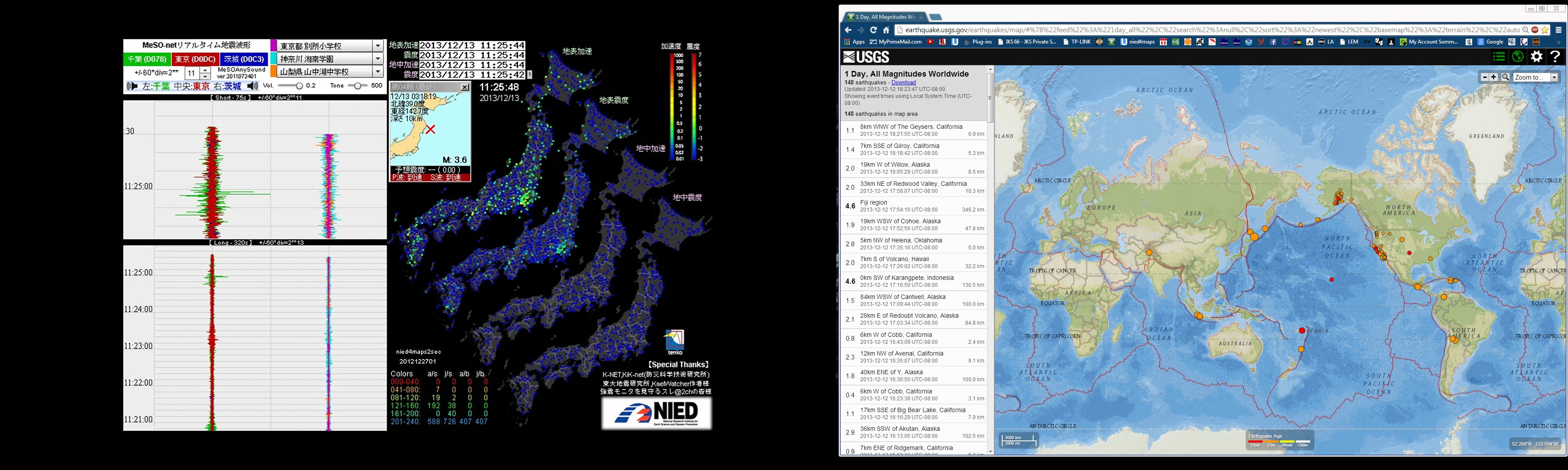
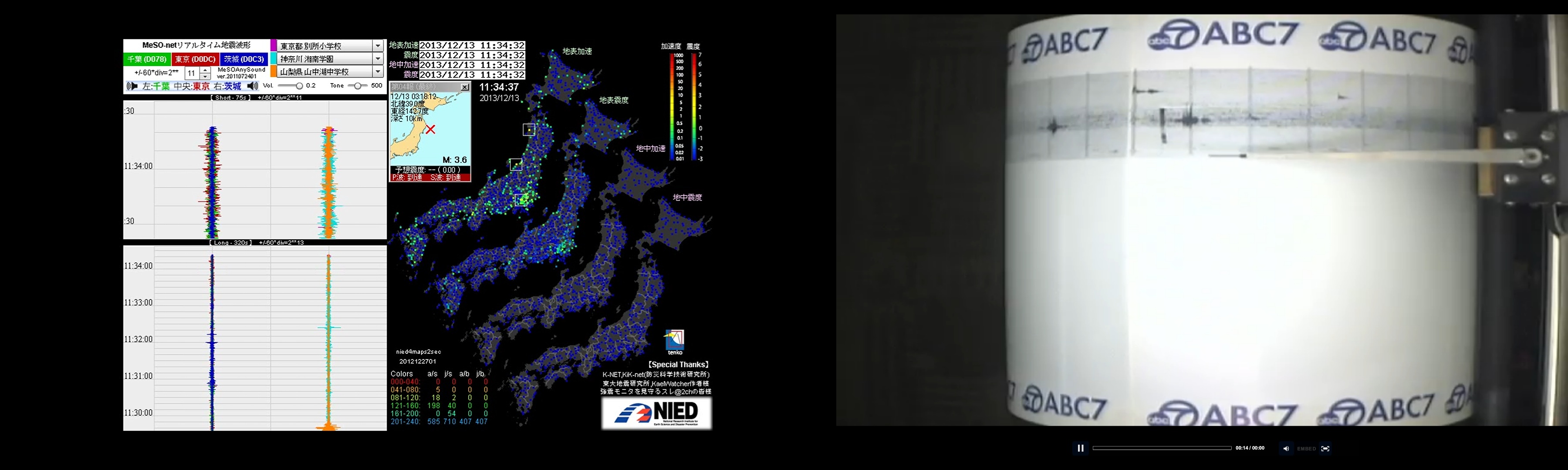
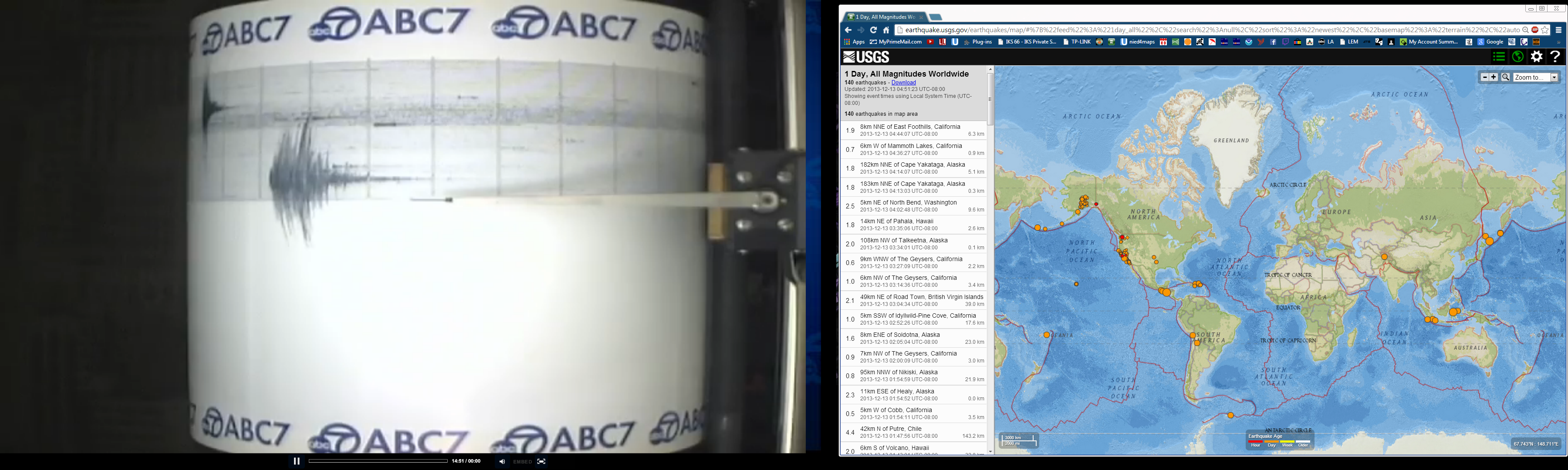
Japan is getting very active right now
www.ustream.tv...
files.abovetopsecret.com...
Also the westcoast
files.abovetopsecret.com...
files.abovetopsecret.com...
www.ustream.tv...
files.abovetopsecret.com...
edit on 7/30/2012 by dreamfox1 because: files.abovetopsecret.com...
Also the westcoast
files.abovetopsecret.com...
files.abovetopsecret.com...
edit on 7/30/2012 by dreamfox1 because: files.abovetopsecret.com...
dreamfox1
Japan is getting very active right now
Oh?
NIED's own data doesn't show that in the latest download
Japan gets approx. 160-300 quakes per day as background seismicity and from my observations it takes a big 6 or 7 to make those numbers jump higher above that norm. I haven't observed any spikes in smaller magnitude quakes on their own.
edit on
12u34634613 by muzzy because: (no reason given)
Like NZ I have noticed that prior to a M6 or M7 there may be a shortage of daily M4's for a week or so, but it is not as pronounced/obvious .
edit on 12u34634613 by muzzy because: (no reason given)
dreamfox1
Japan is getting very active right now
www.ustream.tv...
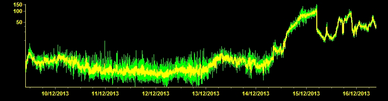
Erm, I bet to differ. There hasn't been anything listable on at least the USGS in 24 hours (I don't actually know when the last 4.5 or higher was. Yesterday or the day before?) Just because it looks like a lit-up Christmas tree on the map doesn't mean it's because it's all seismic activity (it actually goes pretty quiet, both in audio tones & the visual dots, during their overnight) You can easily see the difference between human influence and natural just by looking at the day & night over there. Daytime is "noisier", while their night is much quieter. Right now, it looks like a typical afternoon over there with some tiny quakes sprinkled in here & there (a daily norm, though) Don't get me wrong, I love the NIED maps channel and plug the crap out of it when the inspiration strikes me, but right now? It's quiet & boring. Has been all night (US night)
dreamfox1
Im putting it out there. Im nervous tonight. (Pacific time)
Some part of the west coast of North America may get from a 7 or 9+ Mag quake by later this evening or by tomorrow morning.
I see too much activity tonight and all day long watching it.
I hope nothing happens and i am wrong but i would feel worse if i didn't let others know how i feel.edit on 7/30/2012 by dreamfox1 because: (no reason given)edit on 7/30/2012 by dreamfox1 because: (no reason given)
Well, it wasn't a huge quake, but this mag 4.1 did go off near the San Andreas fault last night. Largest in a few months in the area.
Olivine
dreamfox1
Im putting it out there. Im nervous tonight. (Pacific time)
Some part of the west coast of North America may get from a 7 or 9+ Mag quake by later this evening or by tomorrow morning.
I see too much activity tonight and all day long watching it.
I hope nothing happens and i am wrong but i would feel worse if i didn't let others know how i feel.edit on 7/30/2012 by dreamfox1 because: (no reason given)edit on 7/30/2012 by dreamfox1 because: (no reason given)
Well, it wasn't a huge quake, but this mag 4.1 did go off near the San Andreas fault last night. Largest in a few months in the area.
Yea i just noticed that a few minutes ago as i woke up checking on quake activity. Will be keeping an eye on this area throughout the day.
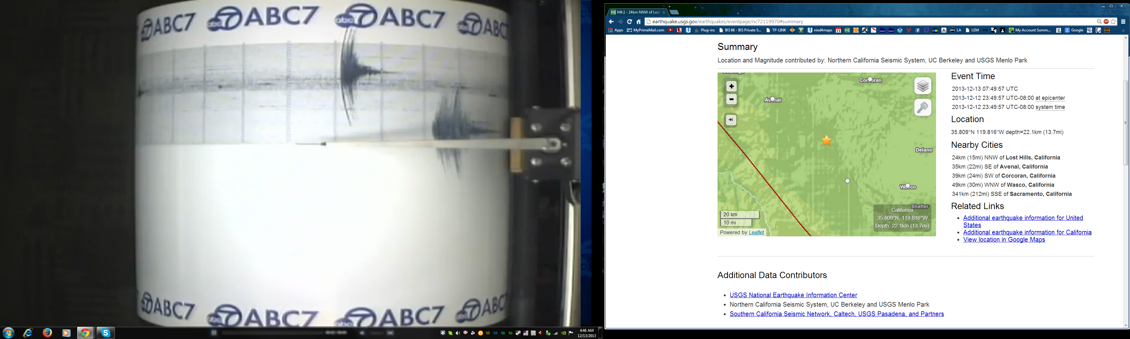
files.abovetopsecret.com...
M4.1
- 24km NNW of Lost Hills, California
2013-12-13 07:49:57 UTC
Event Time
2013-12-13 07:49:57 UTC
2013-12-12 23:49:57 UTC-08:00 at epicenter
2013-12-12 23:49:57 UTC-08:00 system time
Location
35.809°N 119.816°W depth=22.1km (13.7mi)
Nearby Cities
24km (15mi) NNW of Lost Hills, California
35km (22mi) SE of Avenal, California
39km (24mi) SW of Corcoran, California
49km (30mi) WNW of Wasco, California
341km (212mi) SSE of Sacramento, California
earthquake.usgs.gov...
edit on 7/30/2012 by dreamfox1 because:
earthquake.usgs.gov...
files.abovetopsecret.com...
edit on 7/30/2012 by dreamfox1 because:
files.abovetopsecret.com...
This New York Times bit is really good at explaining the basic facts about earthquakes and fracking, and explaining the difference between fracking
and injection. Oklahoma and Texas both had small quakes today. But it can't be fracking and injection- no. It must be that giant rift opening up and
Cthulhu will pop out.

Now, I know you must all be thinking, hey wait, Cthulhu is a sea monster. Yes, this is true. You have a point. But, you can't possibly know what future events are sure to occur. First, the entire mid-west suddenly has a giant methane fart after all the cracks from fracking open all at once. Many, many small earthquakes everywhere. Of course, with that much gas, and spark. Many areas went up in fire. Then the ground suddenly fell out. Not like the stock market bottom falling out. Well, yeah, kinda like that. The ground sank just like it had done in Cali, when back in da olden days of the fifties. Late forties anyway. Suddenly the mid-west sank and created a giant basin.
But you're future forgetting that at the same time, the other oil rigs out in the Gulf sparked the same methane release through earthquakes, and the water thrust upon the land in a tsunami. The newly formed basin of the mid-west now filled with water and now, Cthulhu can emerge through the giant rift formed by the artificial fault the oilboys created. "We're sorry." (When Tony Hayward... www.youtube.com... "
You see, Cthulhu doesn't like to admit he's afraid of sharks. This way, the sharks can stay out in the ocean.
Sorry, here's the very good video of fracking and injection.
www.nytimes.com...
And just a note, the Oklahoma epicenter was unusual. Meaning, it was in ta new location. 1.5km away from an injection well. A ten minute walk. Oh, I should go back and look for lakes. Yup, Great Salt Plains Lake.
Some other reading if you like.
m.livescience.com...
gizmodo.com...
mannfordeagle.com...
I checked the Texas quake and it's surrounded by injection wells.
edit on 13-12-2013 by ericblair4891 because: (no reason given)
edit on 13-12-2013 by ericblair4891 because: (no reason
given)
Anyone have a working link to the closest seismos on Mt. Etna? I can't find any that are working.
reply to post by westcoast
How about this site westcoast?
Link
How about this site westcoast?
Link
edit on 12/15/2013 by whatnext21 because: (no reason given)
reply to post by westcoast
I use these.
They are delayed 10-15 minutes, but automatically update. Once the page loads, if you click on station "STR8", you can see that tremor has eased off in the past hour or two, but the small earthquakes are still cracking.
I use these.
They are delayed 10-15 minutes, but automatically update. Once the page loads, if you click on station "STR8", you can see that tremor has eased off in the past hour or two, but the small earthquakes are still cracking.
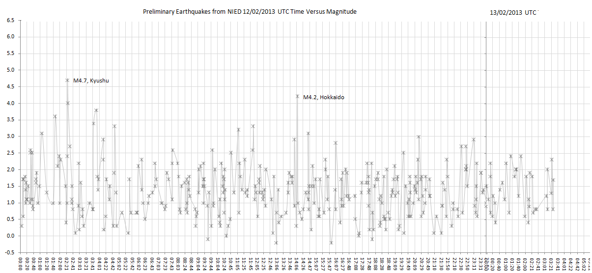
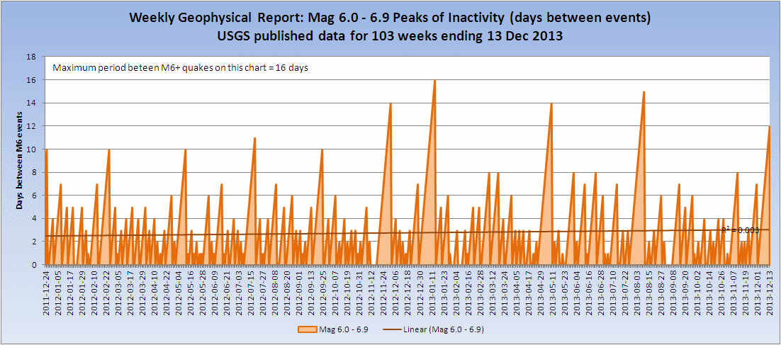
You may not recall but at the end of last year/beginning of this we had a lull in Mag 6+ earthquakes of 16 days that ended on the 15th January 2013
with an M6.1 on the Pacific-Antarctic ridge.
As of yesterday we are at 14 days and counting. If there is no Mag 6+ before Wednesday midnight UTC then that will be 17 days and the longest gap since I started the geophysical reports on 22 December 2011.
I will check back but from memory the longest gap in the last decade is 19 days, I think maybe perhaps.
Olivine
reply to post by westcoast
I use these.
They are delayed 10-15 minutes, but automatically update. Once the page loads, if you click on station "STR8", you can see that tremor has eased off in the past hour or two, but the small earthquakes are still cracking.
The tremor graph on the same site are much better, if it is VT/HT you are after, and the span a longer period. The slight increase on the 15th on the visible seismograms does not now, on the 16th, show that the tremor has subsided dramatically from the 14th.
Click for the source page (2 more images)
update to post by PuterMan
Here is the chart showing the 16 day 'gap'
Click the image to enlarge
I also note that as of today ALL three bands M6, M7, M8 are in the red i.e. have not had a quake in the band that is less than or equal to the average gap between quake - so ALL are overdue.
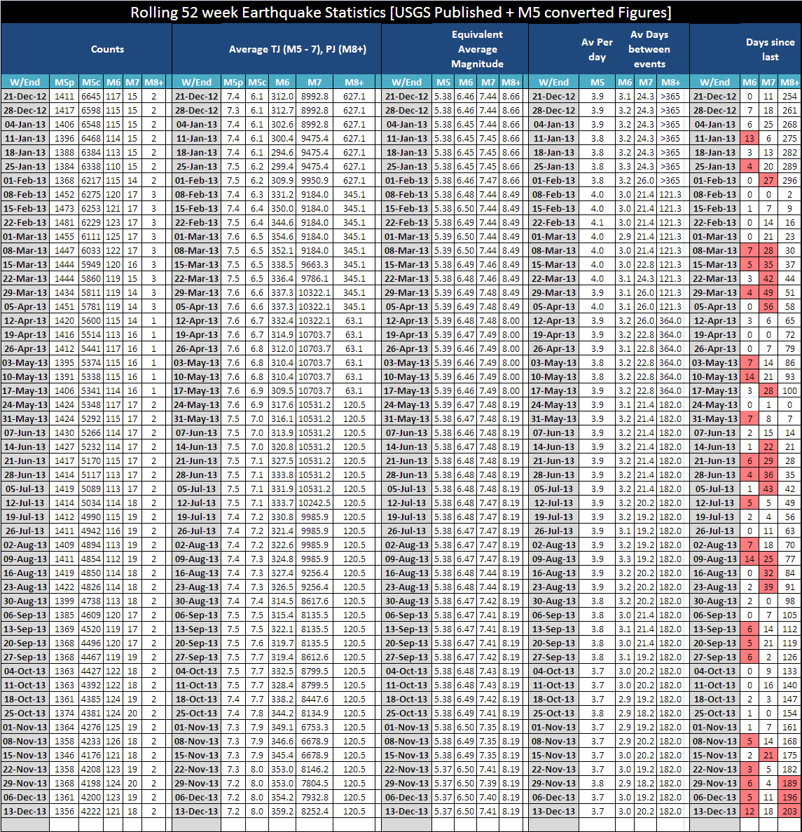
Click the image to enlarge
The Mag 7 band was not over on the date of the report (13th) just about to issue, but is now,
Here is the chart showing the 16 day 'gap'

Click the image to enlarge
I also note that as of today ALL three bands M6, M7, M8 are in the red i.e. have not had a quake in the band that is less than or equal to the average gap between quake - so ALL are overdue.

Click the image to enlarge
The Mag 7 band was not over on the date of the report (13th) just about to issue, but is now,
new topics
-
Former NYT Reporter Attacks Scientists For Misleading Him Over COVID Lab-Leak Theory
Education and Media: 52 minutes ago -
Why did Phizer team with nanobot maker
Medical Issues & Conspiracies: 1 hours ago -
Pro Hamas protesters at Columbia claim hit with chemical spray
World War Three: 1 hours ago -
Elites disapearing
Political Conspiracies: 3 hours ago -
A Personal Cigar UFO/UAP Video footage I have held onto and will release it here and now.
Aliens and UFOs: 3 hours ago -
Go Woke, Go Broke--Forbes Confirms Disney Has Lost Money On Star Wars
Movies: 5 hours ago -
Freddie Mercury
Paranormal Studies: 5 hours ago -
Nirvana - Immigrant Song
Music: 10 hours ago -
British TV Presenter Refuses To Use Guest's Preferred Pronouns
Education and Media: 11 hours ago
top topics
-
British TV Presenter Refuses To Use Guest's Preferred Pronouns
Education and Media: 11 hours ago, 16 flags -
Go Woke, Go Broke--Forbes Confirms Disney Has Lost Money On Star Wars
Movies: 5 hours ago, 12 flags -
Pro Hamas protesters at Columbia claim hit with chemical spray
World War Three: 1 hours ago, 9 flags -
Trump To Hold Dinner with President of Poland At Trump Tower Tonight
2024 Elections: 14 hours ago, 8 flags -
Tucker Carlson interviews Christian pastor from Bethlehem.
Middle East Issues: 13 hours ago, 7 flags -
Elites disapearing
Political Conspiracies: 3 hours ago, 7 flags -
A family from Kansas with six children moved to the Moscow region
Other Current Events: 17 hours ago, 6 flags -
Freddie Mercury
Paranormal Studies: 5 hours ago, 6 flags -
A Personal Cigar UFO/UAP Video footage I have held onto and will release it here and now.
Aliens and UFOs: 3 hours ago, 5 flags -
Nirvana - Immigrant Song
Music: 10 hours ago, 4 flags
active topics
-
Trump To Hold Dinner with President of Poland At Trump Tower Tonight
2024 Elections • 35 • : DBCowboy -
British TV Presenter Refuses To Use Guest's Preferred Pronouns
Education and Media • 46 • : Unknownparadox -
Elites disapearing
Political Conspiracies • 14 • : AwakeNotWoke -
Freddie Mercury
Paranormal Studies • 1 • : AwakeNotWoke -
Why did Phizer team with nanobot maker
Medical Issues & Conspiracies • 1 • : AwakeNotWoke -
Pro Hamas protesters at Columbia claim hit with chemical spray
World War Three • 6 • : DBCowboy -
Former NYT Reporter Attacks Scientists For Misleading Him Over COVID Lab-Leak Theory
Education and Media • 1 • : Dandandat3 -
Gold and silver prices....woo hoo
History • 75 • : SchrodingersRat -
-@TH3WH17ERABB17- -Q- ---TIME TO SHOW THE WORLD--- -Part- --44--
Dissecting Disinformation • 512 • : cherokeetroy -
A Personal Cigar UFO/UAP Video footage I have held onto and will release it here and now.
Aliens and UFOs • 9 • : Ophiuchus1