It looks like you're using an Ad Blocker.
Please white-list or disable AboveTopSecret.com in your ad-blocking tool.
Thank you.
Some features of ATS will be disabled while you continue to use an ad-blocker.

Quake Watch 2013
page: 188share:
Would any of you quake experts care to comment on this thread?? We need experience on this.
www.abovetopsecret.com...
www.abovetopsecret.com...

DANGER.......DANGER
www.isthisthingon.org...
Yellowstone SWARM
2.8
18km NNE of West Yellowstone, Montana
2013-11-23 12:23:48 UTC-08:0011.4 km
2.6
18km NNE of West Yellowstone, Montana
2013-11-23 12:38:12 UTC-08:0011.9 km
2.6
18km NNE of West Yellowstone, Montana
2013-11-23 12:38:12 UTC-08:0011.9 km
3.3
18km NNE of West Yellowstone, Montana
2013-11-23 12:47:35 UTC-08:0011.9 km
2.2
18km NNE of West Yellowstone, Montana
2013-11-23 14:25:44 UTC-08:0011.2 km
2.9
18km NNE of West Yellowstone, Montana
2013-11-23 15:03:06 UTC-08:0011.7 km
earthquake.usgs.gov...
edit on 7/30/2012 by dreamfox1 because: USGS
edit on
7/30/2012 by dreamfox1 because: (no reason given)
reply to post by Cherryontop
yep but nobodyseems to cares....its something they are eager to shove it under the carpet....
couse nobody knows wat the sighnes of an eruption off an super volcano is
and the continues swarms the last year is something that is new for YVO
and still use the criteria of an "normal" strato volcano...
lets see how it works out...
edit on 23-11-2013 by ressiv because: (no reason given)
What's wrong with Quake watch page 188???
I've been trying to get it to scroll for 2 hours!
Can only see the first post!
I tried other pages & other threads, they are working!
SUP???
Obviously, I won't be able to see any answers,
but hopefully someone knows what's wrong.
If it's just my computer, somebody PM me with a solution!
Pretty please!
WOQ
The last swarm never really died down. The numbers would drop into the single digits but then would go back up into the 20s and 30s. Now it seems to
be heating back up with an uncharacteristic string of 2.x plus tremors. But even this is extremely mild compared to a swarm that happened a few years
back that had FEMA preparing for the worst. So, just how far will this swarm go?????
reply to post by mcvities
Uhhhhhhhhhhhhhhhhhhhh
PERSEVERATION . . . particularly angry perseveration . . . is not usually considered to be a healthy thing.
This thread has a LOT to offer those of us who are interested in earthquakes . . . and potentially, millions who NEED to be interested in order to save their lives.
IF a game fosters THAT level of perseverated anger . . . perhaps it's time to find a past time that would be healthier for you.
reply to post by muzzy
I would definitelty agree that IRIS do the best seismograms. I note there is a difference between the one I got from BBNet (the right hand side saye 15000 on GFZ and 5000 on BBNet so they have scaled it down)

Click the image to enlarge
and the one off the GFZ site.
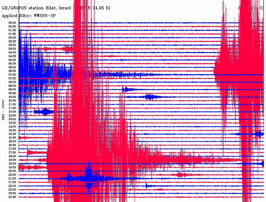
Click the image to enlarge
I would definitelty agree that IRIS do the best seismograms. I note there is a difference between the one I got from BBNet (the right hand side saye 15000 on GFZ and 5000 on BBNet so they have scaled it down)

Click the image to enlarge
and the one off the GFZ site.

Click the image to enlarge
edit on 24/11/2013 by PuterMan because: to add more information
reply to post by PuterMan
THX MUCH. I guess I need to go to the site to see the magnitude.
Appreciate all you do. LUB
THX MUCH. I guess I need to go to the site to see the magnitude.
Appreciate all you do. LUB
reply to post by ressiv
It would appear to be something that has continued from september, but in different areaa. This current Hebgen Lake area is increasing
Curiously however it is just going up and not producing larger quakes in addition to the smaller ones, i.e. the smaller ones are vanishing off the radar.
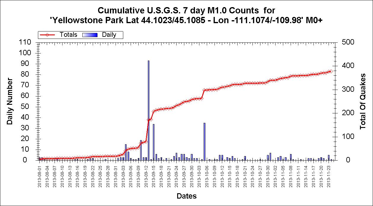
Click the image to enlarge
The energy released shows a slightly different pattern because of the recent M2+
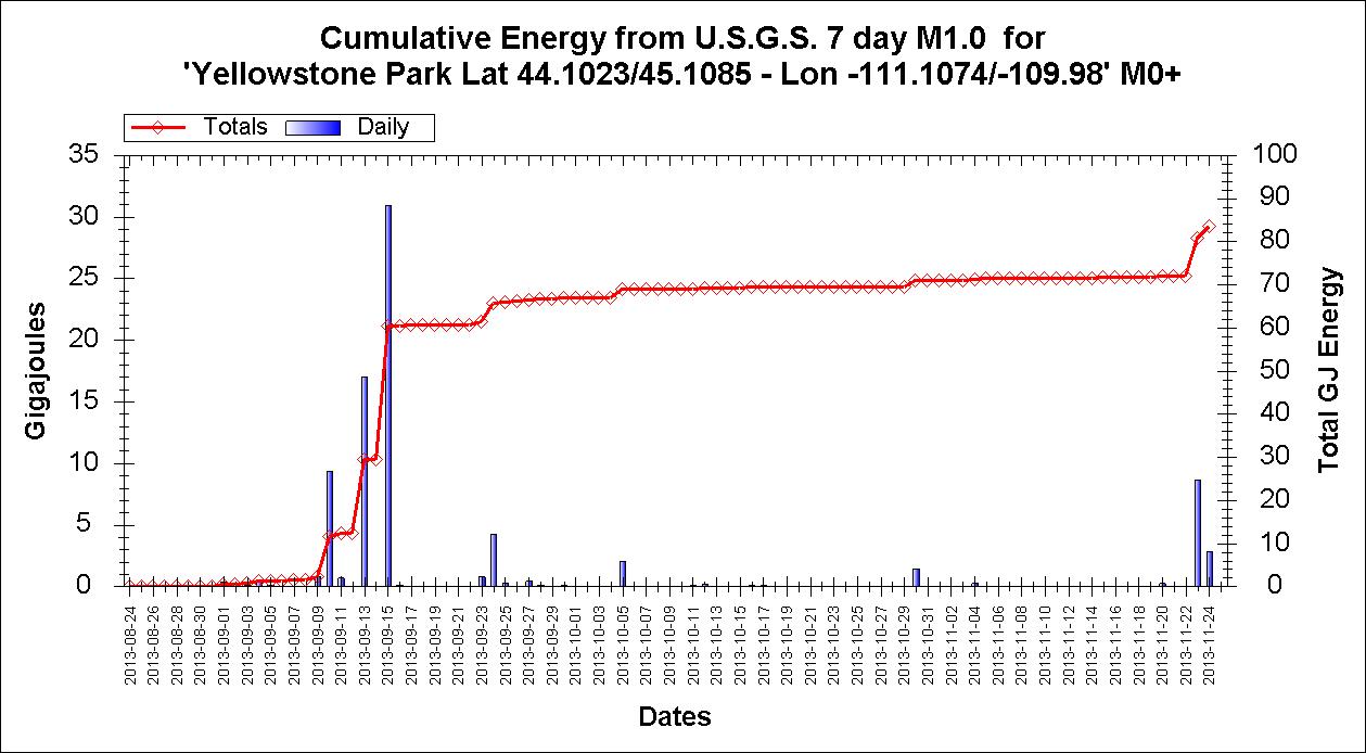
Click the image to enlarge
Time to break out the popcorn?
It would appear to be something that has continued from september, but in different areaa. This current Hebgen Lake area is increasing
Prov,Date/Time UTC,Latitude,Longitude,Magnitude,Depth(Km),Location
usgs,2013-11-24 07:18:35, 44.820, -111.021, 3.1, 11.5, Hebgen Lake Region (458)
usgs,2013-11-23 23:03:06, 44.823, -111.024, 2.9, 11.7, Hebgen Lake Region (458)
usgs,2013-11-23 22:25:44, 44.818, -111.022, 2.2, 11.2, Hebgen Lake Region (458)
usgs,2013-11-23 20:47:35, 44.822, -111.025, 3.3, 11.9, Hebgen Lake Region (458)
usgs,2013-11-23 20:38:12, 44.815, -111.021, 2.6, 11.9, Hebgen Lake Region (458)
usgs,2013-11-23 20:23:48, 44.814, -111.018, 2.8, 11.4, Hebgen Lake Region (458)
usgs,2013-11-21 15:31:43, 44.763, -111.093, 1.4, 14.2, Hebgen Lake Region (458)
usgs,2013-11-20 00:27:49, 44.762, -111.089, 1.5, 10.2, Hebgen Lake Region (458)
usgs,2013-11-19 22:18:38, 44.766, -111.081, 1.3, 10.7, Hebgen Lake Region (458)
usgs,2013-11-19 16:12:07, 44.761, -111.090, 1.5, 10.6, Hebgen Lake Region (458)
usgs,2013-11-16 09:16:15, 44.745, -111.098, 1.2, 10.9, Hebgen Lake Region (458)
usgs,2013-11-15 23:49:47, 44.742, -111.101, 1.1, 11.7, Hebgen Lake Region (458)
usgs,2013-11-15 22:56:25, 44.746, -111.097, 2.0, 11.9, Hebgen Lake Region (458)
usgs,2013-11-08 07:45:26, 44.554, -111.007, 1.1, 12.3, Hebgen Lake Region (458)
usgs,2013-11-08 07:42:44, 44.534, -111.009, 1.4, 9.3, Hebgen Lake Region (458)
usgs,2013-11-08 05:13:52, 44.712, -111.015, 1.4, 10.0, Hebgen Lake Region (458)
usgs,2013-11-08 03:41:34, 44.543, -111.005, 1.3, 10.7, Hebgen Lake Region (458)
usgs,2013-11-08 03:34:21, 44.539, -111.000, 1.0, 10.4, Hebgen Lake Region (458)
usgs,2013-11-08 03:29:58, 44.544, -111.020, 1.4, 4.9, Hebgen Lake Region (458)
Curiously however it is just going up and not producing larger quakes in addition to the smaller ones, i.e. the smaller ones are vanishing off the radar.

Click the image to enlarge
The energy released shows a slightly different pattern because of the recent M2+

Click the image to enlarge
Time to break out the popcorn?
Wow, finally managed to get the weekly report out in a timely manner instead of a week late as it has been.
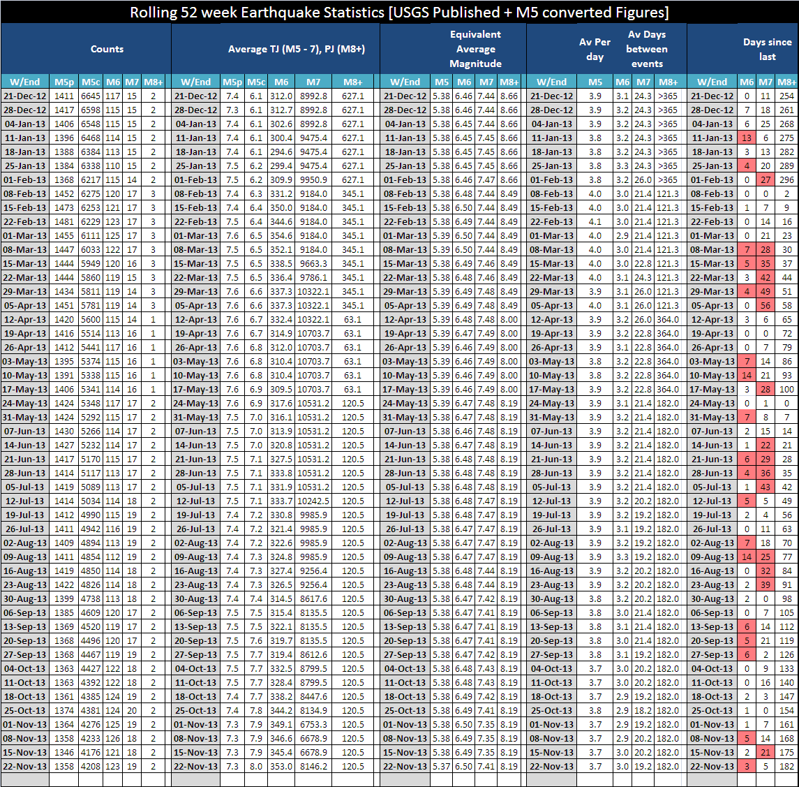
Click the image to enlarge
Link to full report is in my signature as always.

Click the image to enlarge
Link to full report is in my signature as always.
reply to post by ressiv
I care .............. Yellowstone
Apart from August there are 1-3 swarms there each month in 2013.
I wouldn't be overly concerned, when those swarms are 100 x M4 sized then it is time to get out of Dodge.
I care .............. Yellowstone
Apart from August there are 1-3 swarms there each month in 2013.
I wouldn't be overly concerned, when those swarms are 100 x M4 sized then it is time to get out of Dodge.
30 days since the M7.1 FAR E OFF NORTH HONSHU
I have archived each day since then on Global Seismic Archive Interactive Maps. click on the navigation text above the map (below the title) to go forwards in time, or click the October category to see from 25th to 31st Oct then on the November category for ..... November.
The data for Japan 25-31Oct is from the JMA Unified Catalog, which is reviewed data. Jap Nov data is Preliminary data (automatic)
I'm stopping there as I will have to redo the lot, just noticed the Canadian data is missing.
Also added IRIS webicorders
South Pole
Scott Base
Port Moresby, PNG
Matsushiro, Japan to the webicorders drop down menu along with Raoul IS and Wellington which were there already
can't go back any further than 5th November on those as IRIS don't archive them (thats why I'm doing it)
edit on 1100000032732713 by muzzy
because: (no reason given)
Thank you to the mod who removed the post of 616 frowning face icons!!!!
Apparently, that's what was freaking out the page in IE for me.
It worked fine when I switched to Chrome & when I saw them I figured!
Now back to reading quake talk!
I was so afraid I would miss something important,
like Yellowstone, until I thought of trying Chrome! Lol!
WOQ
Apparently, that's what was freaking out the page in IE for me.
It worked fine when I switched to Chrome & when I saw them I figured!
Now back to reading quake talk!
I was so afraid I would miss something important,
like Yellowstone, until I thought of trying Chrome! Lol!
WOQ
opposite ends of the World
geofon.gfz-potsdam.de...
2013-11-25 06:27:11 M6.5 54.03°S 55.26°W 10 A Falkland Islands Region
2013-11-25 05:56:46 M6.0 45.59°N 151.05°E 10 A Kuril Islands
geofon.gfz-potsdam.de...
reply to post by muzzy
I have a feeling that those two won't be the only 2 x 6+'s over the coming 24 hours...
I'm picking maybe another 1-2 in that time-frame...
I have a feeling that those two won't be the only 2 x 6+'s over the coming 24 hours...
I'm picking maybe another 1-2 in that time-frame...
reply to post by muzzy
USGS has this one now at 7.0
USGS
EMSC 6.7
USGS has this one now at 7.0
M7.0 - South Atlantic Ocean
2013-11-25 06:27:33 UTC
Event Time
2013-11-25 06:27:33 UTC
2013-11-25 02:27:33 UTC-04:00 at epicenter
2013-11-25 00:27:33 UTC-06:00 system time
Location
53.881°S 54.882°W depth=10.0km (6.2mi)
Nearby Cities
314km (195mi) SE of Stanley, Falkland Islands
877km (545mi) E of Ushuaia, Argentina
998km (620mi) ESE of Rio Gallegos, Argentina
1031km (641mi) SE of Puerto Deseado, Argentina
314km (195mi) SE of Stanley, Falkland Islands
USGS
EMSC 6.7
edit on 25-11-2013 by lurksoften because: (no reason
given)
reply to post by lurksoften
yeah looking more that size, GFZ have 6.9 now been reviewed by Senor Manual
quite a few M5 aftershocks
Surprisingly South Pole IRIS not showing anything, unlike the Scotia Sea M7 and M6's
however..............
EFI- Mount Kent, East Falkland Island IRIS graph

yeah looking more that size, GFZ have 6.9 now been reviewed by Senor Manual
quite a few M5 aftershocks
Surprisingly South Pole IRIS not showing anything, unlike the Scotia Sea M7 and M6's
however..............
EFI- Mount Kent, East Falkland Island IRIS graph
new topics
-
Las Vegas UFO Spotting Teen Traumatized by Demon Creature in Backyard
Aliens and UFOs: 1 hours ago -
2024 Pigeon Forge Rod Run - On the Strip (Video made for you)
Automotive Discussion: 2 hours ago -
Gaza Terrorists Attack US Humanitarian Pier During Construction
Middle East Issues: 2 hours ago -
The functionality of boldening and italics is clunky and no post char limit warning?
ATS Freshman's Forum: 3 hours ago -
Meadows, Giuliani Among 11 Indicted in Arizona in Latest 2020 Election Subversion Case
Mainstream News: 4 hours ago -
Massachusetts Drag Queen Leads Young Kids in Free Palestine Chant
Social Issues and Civil Unrest: 4 hours ago -
Weinstein's conviction overturned
Mainstream News: 6 hours ago -
Supreme Court Oral Arguments 4.25.2024 - Are PRESIDENTS IMMUNE From Later Being Prosecuted.
Above Politics: 7 hours ago -
Krystalnacht on today's most elite Universities?
Social Issues and Civil Unrest: 7 hours ago -
Chris Christie Wishes Death Upon Trump and Ramaswamy
Politicians & People: 8 hours ago
top topics
-
Krystalnacht on today's most elite Universities?
Social Issues and Civil Unrest: 7 hours ago, 9 flags -
Weinstein's conviction overturned
Mainstream News: 6 hours ago, 6 flags -
University of Texas Instantly Shuts Down Anti Israel Protests
Education and Media: 10 hours ago, 6 flags -
Supreme Court Oral Arguments 4.25.2024 - Are PRESIDENTS IMMUNE From Later Being Prosecuted.
Above Politics: 7 hours ago, 5 flags -
Massachusetts Drag Queen Leads Young Kids in Free Palestine Chant
Social Issues and Civil Unrest: 4 hours ago, 4 flags -
Meadows, Giuliani Among 11 Indicted in Arizona in Latest 2020 Election Subversion Case
Mainstream News: 4 hours ago, 4 flags -
Chris Christie Wishes Death Upon Trump and Ramaswamy
Politicians & People: 8 hours ago, 2 flags -
Any one suspicious of fever promotions events, major investor Goldman Sachs card only.
The Gray Area: 12 hours ago, 2 flags -
Gaza Terrorists Attack US Humanitarian Pier During Construction
Middle East Issues: 2 hours ago, 2 flags -
2024 Pigeon Forge Rod Run - On the Strip (Video made for you)
Automotive Discussion: 2 hours ago, 1 flags
active topics
-
University of Texas Instantly Shuts Down Anti Israel Protests
Education and Media • 195 • : CriticalStinker -
Supreme Court Oral Arguments 4.25.2024 - Are PRESIDENTS IMMUNE From Later Being Prosecuted.
Above Politics • 70 • : Annee -
Weinstein's conviction overturned
Mainstream News • 20 • : Xtrozero -
Cats Used as Live Bait to Train Ferocious Pitbulls in Illegal NYC Dogfighting
Social Issues and Civil Unrest • 22 • : NoviceStoic4 -
Sunak spinning the sickness figures
Other Current Events • 22 • : angelchemuel -
Massachusetts Drag Queen Leads Young Kids in Free Palestine Chant
Social Issues and Civil Unrest • 10 • : Cre8chaos79 -
Nearly 70% Of Americans Want Talks To End War In Ukraine
Political Issues • 93 • : Xtrozero -
Fossils in Greece Suggest Human Ancestors Evolved in Europe, Not Africa
Origins and Creationism • 88 • : Xtrozero -
Gaza Terrorists Attack US Humanitarian Pier During Construction
Middle East Issues • 20 • : Justsomeboreddude3 -
Thousands Of Young Ukrainian Men Trying To Flee The Country To Avoid Conscription And The War
Other Current Events • 141 • : Consvoli