It looks like you're using an Ad Blocker.
Please white-list or disable AboveTopSecret.com in your ad-blocking tool.
Thank you.
Some features of ATS will be disabled while you continue to use an ad-blocker.

Bolivia's Mysterious Ancient El Fuerte (The Fortress)
page: 1share:
I'm about ready to post another long unrelated Ancient civilization's thread but thought I'd first share with you one of my favorites sites in Bolivia this time. El Fuerte [The Fortress] I'm sure some here are already familiar with this site.
El Fuerte Bolivia
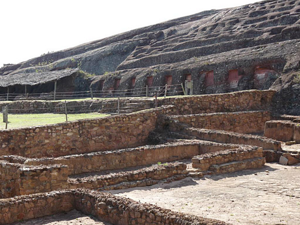
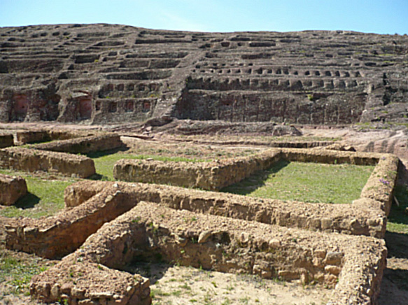
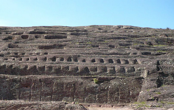
Not far away from Samaipata, one of the most important archeological monuments of pre-Columbian time in Bolivia can be found: El Fuerte (The Fortress). This archeological place has been declared Cultural Patrimony of Humanity by UNESCO. This mysterious place has been given many hypothetical explanations for its origins. It is supposed that El Fuerte is the work of the Amazonian pre-Incan 'Chané' culture, and later on was used as an advanced city by the Incas and finally by the Spanish colonists that turned El Fuerte into a fortress.
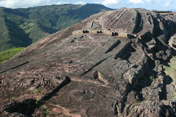
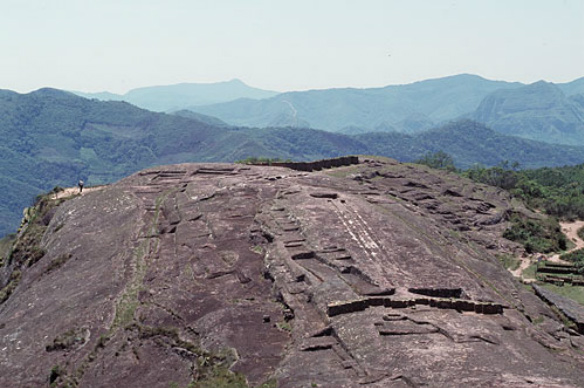
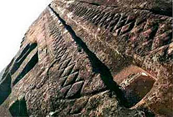
El Fuerte near Samaipata from aside village near el fuerte El Fuerte is the largest carved stone in the world. This archaeological monument reaches a height of 1.949 metres above sea level and is on the ridge of a hill of a sandy rock where ancient cultures sculptured figures but emphasized snakes and pumas, as well as waterways and wells, triangular and rectangular seats, vaulted niches, among other details.
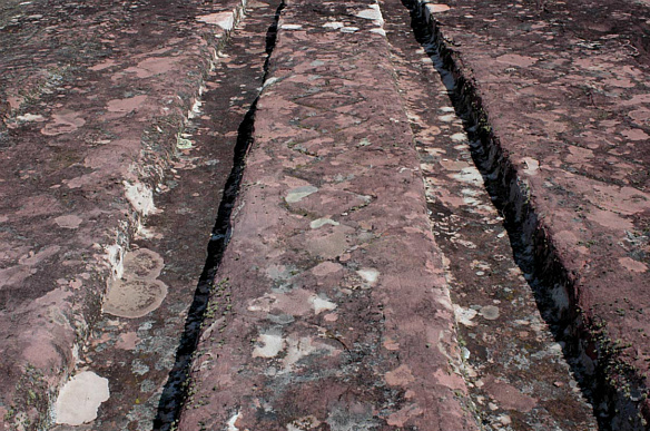
In the next few images you'll notice the two parallel running grooves carved into the rock point out into the sky. Von Daniken speculated they were a launching mechanism of some sort for either ETs or Early manned flight by humans. Now, I don't know about that. To me the site seems to have gone through many phases.
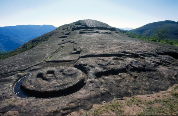
Here are a couple of close ups of the grooves. You'll notice there are some stylized decorative carvings along side them. What was their true purpose? I've read quite a few explanations. To be honest I'm not convinced of any of them [Including Von Danikens]
Now around the base of the site we find these rather interesting carvings. It does resemble doorways. Were they meant as spiritual portholes into another realm? Possibly, in their creators minds, who knows what they were thinking. I'll post a few images.
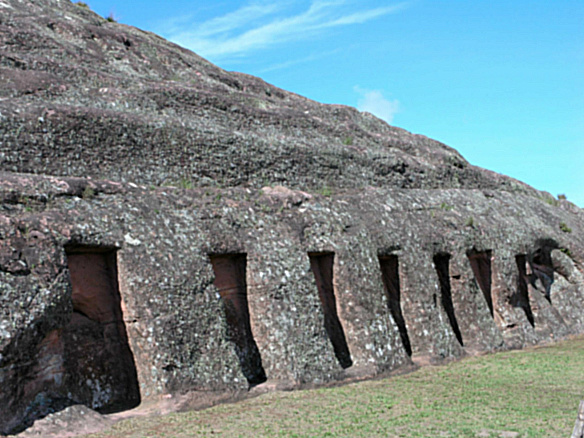
Some of speculated that during one of the many phases the site has gone through that it may have been even used as a quarry. These last two images show signs in my opinion of the site being used at one time as either a quarry or possible a location where young stone carvers may have learned, practiced and perfected their trade.
And finally a short video with more images of this wonderfully strange location.
Enjoy
Anyhoo.
That's all for now. I'll be posting what I hope will be an interesting angle on a very well known and controversial location later today.
Stay tuned
edit on 22-9-2012 by SLAYER69 because: (no reason given)
Star & Flagged, I can honestly say that I am impressed with the structure, but as you say, I don't quite agree with Von Daniken's theory.
I've looked more into this before and it seems more along the lines of an area for a lord and peasant village of the European Middle Ages, where Feudalism was a rampant way of life.
It looks like those carved areas on the rock surface were for ancient plumbing or runoff, the structures on the land look like work areas for peasantry if not housing.
But there's nothing that leads me to believe this was a launch area or in relation to the ancient alien theory.
fascinating, I never seen those images before, nice post.
I doubt that its a launch pad for von dankens aliens. I would guess those channels dug into the rock could be for some ritual water cerermony or possibly to observe the shadow of the sun on certain times of the year like how the shadow runs down the side of the pyramid at Chitzen itza. thats just a guess of course.
I doubt that its a launch pad for von dankens aliens. I would guess those channels dug into the rock could be for some ritual water cerermony or possibly to observe the shadow of the sun on certain times of the year like how the shadow runs down the side of the pyramid at Chitzen itza. thats just a guess of course.
reply to post by SLAYER69
it seem that those two parralell groves might collect rain water? it hard to tell with out actully being there and observing, if u could be there to see if water flows down those groves maybe that may be a away to get inside "the fortress"
it seem that those two parralell groves might collect rain water? it hard to tell with out actully being there and observing, if u could be there to see if water flows down those groves maybe that may be a away to get inside "the fortress"
s +f again... you're one of the few reasons i keep coming back to this site slayer! love your threads, still!
reply to post by FoxStriker
There is a lost of speculation to it's origin and purpose. I posted this to read others perspectives and get some feedback. Your reply and contribution is appreciated.
There is a lost of speculation to it's origin and purpose. I posted this to read others perspectives and get some feedback. Your reply and contribution is appreciated.
Thanks Slayer I`d never even heard of this place. Excellent photos and a very interesting site. I shall look forwards to your thread on it all.
reply to post by Angrybadger
The water speculation seems to be the big theory.
The issue there is that in this location the average rain fall is ample for local farming. So, unless the site is much older than believed and created during a period where the local environment was much dryer then in that case either rain god worship or water collection would have been it's original purpose...
reply to post by DocHolidaze
I wonder if they have or had an astronomical correlation of some sort that may not be apparent presently. Which could indicate a much older site than is presently believed.
I wonder if they have or had an astronomical correlation of some sort that may not be apparent presently. Which could indicate a much older site than is presently believed.
Originally posted by ladyteeny
s +f again... you're one of the few reasons i keep coming back to this site slayer! love your threads, still!
Thank you.
The feedback is appreciated.
Another excellent post, Slayer, thankyou for sharing this. I also agree that it doesn't really "cry" ancient alien to me upon viewing the grooves.
Irrigation was the first thing that came to mind. But I find location, up high on a hilltop, to once again be the most interesting feature of this
site. Maybe the site is post flood, (not the creationist version of the flood but the ice age meltdown), which would explain its builders choice of
location and possible reverence/worship of a water deity.

reply to post by TheSparrowSings
I know.
With South America it's always like at the top of some high up location.
"Let's build on a spot way up top of a mountain and use HUGE boulders and create something completely unusual"
I know.
With South America it's always like at the top of some high up location.
"Let's build on a spot way up top of a mountain and use HUGE boulders and create something completely unusual"
I have never heard of this amazing site before, thank you for posting this, it's absolutely amazing!!!
And do the mysterious tracks remind anyone else of the even more enigmatic "cart tracks" of Malta? Very similar but many more of them, going up and down hills and even over cliffs if I recall correctly. Water collection would seem an odd purpose given the far more practical methods known elsewhere in the areas.
One question tho -and forgive me if I missed it - but I'm not sure the scale of this place? Is the rail system by the "doorways" cut into the side in the lower pictures human sized hand rails? Trying to get a sense how large it all is.
Added: oh there it is, a scale key - thank you! And now even more impressive!
But again, thank you for a most fascinating post of a place I'd never come across and I love reading upon all the mysterious ancient sites of our sadly mundane modern world that was apparently once far more interesting (or perhaps just seems that way because we can't know the real purposes or manner of construction of many of these sites). But the similarity to the Malta tracks - and heck, the site as a whole even reminds me of Yonaguni, though a bit more dry of course. :-)
Awesome, thanks mate!
edit on 22-9-2012 by NewtonDKC because: (no reason given)
That's actually pretty impressive...
thanks for posting it..good find..
thanks for posting it..good find..
reply to post by SLAYER69
Perhaps they poured the blood of their captured rivals in those grooves for some sort of ritual purpose.
Perhaps they poured the blood of their captured rivals in those grooves for some sort of ritual purpose.
Well, I never heard of this! Learn something new everyday.
I do not believe it was *aliens*.
Very skilled artist, some of the best of their time.
Story is fascinating some times a little fantasist
Maybe it WAS aliens
S and F OP
I do not believe it was *aliens*.
Very skilled artist, some of the best of their time.
Story is fascinating some times a little fantasist
Maybe it WAS aliens
S and F OP
Dang you Slayer!!!! Been reading up on possibilities for the last two hours.
I'm not too big on the water collection theory.
I may be off but I will throw it out there. The area reminds me of a big bird. Maybe it started off like that and later generations changed the design.
I see a bird like this photowhen I look at it from this angle
As far as the parallel lines, well I have no explanation for that.
Great thread... Enjoy my wild imagination.
edit on 22-9-2012 by jam321 because: (no reason given)
- The old name of El Fuerte (Samaipata, Bolivia) is not lost as many historians believe. It is misunderstood because the name of El Fuerte is very wellknown: Huanacauri ('rainbow').
After the Qorikancha (Coricancha) in Cuzco the second most important shrine of the Inca's. (from: the Incas, Terence N. D'Altroy, 2002:51): "Their meandering journey eventually led the company to the top of a mountain beyond which they could see a fruitfull valley graced by a rainbow- a manifest sign of their long-sought homeland. Before they could descend the slopes, however brother Ayar Uchu was transformed into a stone. (Both the stone and the mountain became known as Huanacauri and were revered as shrines of surpassing sanctity.) At Managua, Mama Waqo- some said Manqo Qhapaq (Manco Ccapac)called hist brother Ayar Awka to him and said, "Brother! Do you remember that we agreed that you would take possession of the land we would inhabit? Now then, look at that rock! Fly over there (for they said he had been born with wings), sit down on it, and claim the seat where the marker is, because we are going to occupy it and live [here]!" (Sarmiento 1960:217)
On p. 163 (The Inca's by Terence d'Altroy)we can read: "the name Huanacauri was applied repeatedly to locations around Cuzco and to important peaks in the empire, as the Incas imprinted their mythical past on an expanded domain (Van de Guchte 1990:53-4). In fact there were more than one 'Huanacauri's'. But El Fuerte deserves the title of the second important shrine in the Inca empire because it has a marker (see next) which can be dated and it is, indeed, Pre-Inca. - the two parallel shafts of El Cascabel mark the parallel rising of Regulus and Venus on august 17 of the year 1066 AD. It is a very special year because in this year the soul of a mythical king could be watched in the morning and/or evening sky.
Many cultures around the world believed that the tail of a comet marked the death of a king. Every about 76-79 years Halley's comet passes by and it sure did in march of the year 1066 AD. It could easily been seen by the naked eye and it freightened millions of people around the world. Because of the viewing direction of El Cascabel (71 degrees) and precession we know that Regulus must have been visible between 1000 BC and 1100 BC. But not al the dates show a parallel rise of Venus and Regulus in the viewing direction of 71 degrees. There was only one appearance of Halley's comet and in the same year the parallel rising of Venus and Regulus could be watched.
El Fuerte de Samaipata
I believe it was Planetary, in its building.
S&F
reply to post by SLAYER69
maybe its me. but the looks sooooo much like the represention of some type of craft/ship.
maybe its me. but the looks sooooo much like the represention of some type of craft/ship.
new topics
-
Former NYT Reporter Attacks Scientists For Misleading Him Over COVID Lab-Leak Theory
Education and Media: 3 minutes ago -
Why did Phizer team with nanobot maker
Medical Issues & Conspiracies: 18 minutes ago -
Pro Hamas protesters at Columbia claim hit with chemical spray
World War Three: 38 minutes ago -
Elites disapearing
Political Conspiracies: 2 hours ago -
A Personal Cigar UFO/UAP Video footage I have held onto and will release it here and now.
Aliens and UFOs: 2 hours ago -
Go Woke, Go Broke--Forbes Confirms Disney Has Lost Money On Star Wars
Movies: 4 hours ago -
Freddie Mercury
Paranormal Studies: 5 hours ago -
Nirvana - Immigrant Song
Music: 9 hours ago -
British TV Presenter Refuses To Use Guest's Preferred Pronouns
Education and Media: 10 hours ago
top topics
-
British TV Presenter Refuses To Use Guest's Preferred Pronouns
Education and Media: 10 hours ago, 16 flags -
Go Woke, Go Broke--Forbes Confirms Disney Has Lost Money On Star Wars
Movies: 4 hours ago, 12 flags -
Trump To Hold Dinner with President of Poland At Trump Tower Tonight
2024 Elections: 13 hours ago, 8 flags -
Tucker Carlson interviews Christian pastor from Bethlehem.
Middle East Issues: 12 hours ago, 7 flags -
Elites disapearing
Political Conspiracies: 2 hours ago, 7 flags -
Pro Hamas protesters at Columbia claim hit with chemical spray
World War Three: 38 minutes ago, 6 flags -
A family from Kansas with six children moved to the Moscow region
Other Current Events: 16 hours ago, 6 flags -
A Personal Cigar UFO/UAP Video footage I have held onto and will release it here and now.
Aliens and UFOs: 2 hours ago, 5 flags -
Freddie Mercury
Paranormal Studies: 5 hours ago, 5 flags -
Nirvana - Immigrant Song
Music: 9 hours ago, 4 flags
active topics
-
-@TH3WH17ERABB17- -Q- ---TIME TO SHOW THE WORLD--- -Part- --44--
Dissecting Disinformation • 512 • : cherokeetroy -
A Personal Cigar UFO/UAP Video footage I have held onto and will release it here and now.
Aliens and UFOs • 9 • : Ophiuchus1 -
Former NYT Reporter Attacks Scientists For Misleading Him Over COVID Lab-Leak Theory
Education and Media • 0 • : Consvoli -
Terrifying Encounters With The Black Eyed Kids
Paranormal Studies • 42 • : daskakik -
Elites disapearing
Political Conspiracies • 12 • : Degradation33 -
Candidate TRUMP Now Has Crazy Judge JUAN MERCHAN After Him - The Stormy Daniels Hush-Money Case.
Political Conspiracies • 318 • : matafuchs -
The Shed 26
General Chit Chat • 836 • : MRTrismegistus -
British TV Presenter Refuses To Use Guest's Preferred Pronouns
Education and Media • 44 • : ImagoDei -
Pro Hamas protesters at Columbia claim hit with chemical spray
World War Three • 3 • : Lumenari -
Why did Phizer team with nanobot maker
Medical Issues & Conspiracies • 0 • : annonentity