It looks like you're using an Ad Blocker.
Please white-list or disable AboveTopSecret.com in your ad-blocking tool.
Thank you.
Some features of ATS will be disabled while you continue to use an ad-blocker.

Sol 3's images just in. All in glorious colour!
page: 4share:
I keep getting an error message when I click on the link in the OP. Is it just me?
It's says "ERROR: The link could not be satisfied."
EDIT: Nevermind. I finally got in. I think the site is experiencing heavy traffic.
It's says "ERROR: The link could not be satisfied."
EDIT: Nevermind. I finally got in. I think the site is experiencing heavy traffic.
edit on 8/10/2012 by gemineye because: (no reason
given)
reply to post by gemineye
The images are mostly the thumbnails which were used to assemble the panorama.
photojournal.jpl.nasa.gov...
The images are mostly the thumbnails which were used to assemble the panorama.
photojournal.jpl.nasa.gov...
Originally posted by Wrabbit2000
reply to post by AmatuerSkyWatcher
Seriously, was this where they meant to land? I understand safety in not wanting to hit anything..but it looks so barren? Won't they have some real travel distance to get to something more interesting than the field of endless loose stones?
I'm sure they planned all this out...but that is why I ask, is this actually the target landing zone? Thanks anyone who can help.
The answer to your question is yes. This is precisely where the team was expecting MSL to land. I believe they only missed the actual target by 800 feet or so. Not bad at all.
Cheers
LOL it would be funny if this was all being shot at the Arizona desert
Originally posted by Soylent Green Is People
Originally posted by Wrabbit2000
reply to post by AmatuerSkyWatcher
Err... they went millions of miles to land their Buck Rogers rover..in Barstow? lol....
Seriously, was this where they meant to land? I understand safety in not wanting to hit anything..but it looks so barren? Won't they have some real travel distance to get to something more interesting than the field of endless loose stones?
I'm sure they planned all this out...but that is why I ask, is this actually the target landing zone? Thanks anyone who can help.
There is a very good chance Gale Crater (the landing site) is an ancient lake bed. NASA landed there because it shows several signs of once being a very wet place.
Perhaps some of that lakebed (the crater floor) has been covered by dust over time, but there are higher areas around nearby Mt. Sharp that have exposed rock strata -- strata which may have been formed from sediment laid down by the lake that was once there.
So Gale Crater was picked by NASA for its geology and because it looks like a place that could have been suitable for the formation of life.
If Mars ever had water and clouds and was much like Earth...don't you think that evidence of water should be found everywhere on Mars..?
With other words......why not sent the rover to a more diverse (flat) landscape?
reply to post by zatara
Do a test. Get a plate and poor half a glass of water on it. Then do the same but using a bowl instead of a plate.
Do a test. Get a plate and poor half a glass of water on it. Then do the same but using a bowl instead of a plate.
Why is it "cool" to pretend that scientists and engineers are teh stupidz?
Newsflash: they are smarter than you. and me.
I see.
I asked because we know (or at least we are pretty sure) that there are underground water reservoirs in at least two moons (Enceladus was one, I don't remember the other) where from time to time water surfaces via "geysers".
I was wondering if in past mars there may have been considerable amounts of H2O in the atmosphere or maybe there are/were undergound reservoirs that regularly surface near to places with volcanic activity.
Thanks for your answer!
Newsflash: they are smarter than you. and me.
Originally posted by AmatuerSkyWatcher
reply to post by drakus
Well considering Mars' similarities with Earth, if there was a significant amount of water, I'd expect to see similar results as Earth (including weather effects).
So I think both are very likely and aren't mutually exclusive to one another. For there to be water coming from spings, the water will be coming from elsewhere, getting heated, then being thrust back to the surface. It won't be being created by the spring as I understand it.
EDIT: What I'm basically saying is, there will be some kind of cycle, very similar to Earth, in regard to H2O distribution.edit on 10-8-2012 by AmatuerSkyWatcher because: (no reason given)
I see.
I asked because we know (or at least we are pretty sure) that there are underground water reservoirs in at least two moons (Enceladus was one, I don't remember the other) where from time to time water surfaces via "geysers".
I was wondering if in past mars there may have been considerable amounts of H2O in the atmosphere or maybe there are/were undergound reservoirs that regularly surface near to places with volcanic activity.
Thanks for your answer!
I have to say I have never been more excited for a planet, rock to be investigated. Unless of course, Titan actually plays out. I would pay to go
there, one way trip and die there.
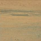
At first glance I was incredibly disappointed as others have been, but this barren field shows signs of volcanic activity, as well as plenty of iron, which along with water and lightning produce the fundamental strands of protein for life to form. Every little bit counts, and it seems to many were hoping for the rover to explore the "face" or "pyramids". I will admit I too would like to see the sights from a ground level perspective, how ever the gale crater has some significant images sent back already. I've noticed in a few of the images, there are patches of an almost clay coloured soil among a sea of orange. This could suggest many things, how ever my first thought was water. The thumbnails are annoying but I will try to link to the ones I'm referencing.
These could be patches left from volcanic activity as well, but my first thought was water.
mars.jpl.nasa.gov...
mars.jpl.nasa.gov...
mars.jpl.nasa.gov...
mars.jpl.nasa.gov...
There is a lot to how different minerals are formed and dispersed, a majority of these minerals are present at the formation of the planet, volcanic activity, water, and life happen to move and deposit these things into different densities rather than violent dust storms turning it into one finely mixed powder.
Originally posted by Wrabbit2000
reply to post by AmatuerSkyWatcher
Err... they went millions of miles to land their Buck Rogers rover..in Barstow? lol....
Seriously, was this where they meant to land? I understand safety in not wanting to hit anything..but it looks so barren? Won't they have some real travel distance to get to something more interesting than the field of endless loose stones?
I'm sure they planned all this out...but that is why I ask, is this actually the target landing zone? Thanks anyone who can help.
The "target" is under the surface.
Originally posted by ChaoticOrder
reply to post by wildapache
I'm not asking for aliens... I'm asking for something other than close up pics of dirt. Like nice scenic landscape views which can give us a nice feel of the area.
Do People realize that this is a science expedition and not some tourism/lets visit the aliens houses over there expedition?edit on 10/8/2012 by ChaoticOrder because: (no reason given)
NASA has sent up a "lab on wheels" intended to take samples of the soil and look for certain organic markers. Anyone expecting a sign saying "ET was here" or ruins of an ancient temple will be disappointed. It landed in a crater in order to increase the possibility of discovering organic compounds in the soil.
reply to post by drakus
Well I am sure there are old volcanic chambers that were emptied of magma and were sealed off for some reason. Hawaii has loads of such chambers dotted here, there and everywhere as a good example. They will naturally be filled with water that seeps in through fissures etc, over time.
Obviously, the bigger the chamber, the more water it will hold. The more water held, the more likely that water would outlast the surface water.
I suppose it's possible for these reservoirs to still exist on Mars, but they would surely have to be completely sealed from the outside world, so finding such would be highly unlikely (if not impossible) at the moment.
I'm not sure I have ever heard of a reservoir completely sealed off. Although, wasn't there an example in Africa somewhere lately?
reply to post by zatara
>>
So Gale Crater was picked by NASA for its geology
>>
It is not so much Gale Crater they want to examine, but Mt. Sharp in the middle of it. Mt. Sharp because it exposes several sediment layers, corresponding to various geological pasts of Mars. Any of those layers might contain information about whether life was on Mars at a specific time back - which is a common assumption.
I am not sure myself whether the crater *itself* has any relevance, beside that it's convenient, flat and close to the mountain.
>>
So Gale Crater was picked by NASA for its geology
>>
It is not so much Gale Crater they want to examine, but Mt. Sharp in the middle of it. Mt. Sharp because it exposes several sediment layers, corresponding to various geological pasts of Mars. Any of those layers might contain information about whether life was on Mars at a specific time back - which is a common assumption.
I am not sure myself whether the crater *itself* has any relevance, beside that it's convenient, flat and close to the mountain.
edit on 10-8-2012 by flexy123 because: (no reason given)
reply to post by AmatuerSkyWatcher
There is evidence of vast areas of ice under the Martian surface. However, if that ice ever melts, and if it makes it to the surface, it cannot last long. The atmospheric pressure is too low to allow liquid water to persist. It would "boil" away.
It is possible that liquid water heavy with salts would last longer than pure water but it would still evaporate quite quickly.
www.space.com...
Why din't come to Cydonia with the infamous face?
Could be interesting!!
SNC.
Could be interesting!!
SNC.
edit on 8/10/2012 by snc24 because: (no reason given)
Originally posted by snc24
Why din't come to Cydonia with the inafamous face?
Could be interesting!!
SNC.
You missed this by about 14 years. They imaged the cydonia region in 1998 with the MOC (Mars Orbiter Camera).
This one looks "pretty":
(or at least it will in the full version)
I'd like to know what those dark patches are...
Yes, it was in the news a while ago.

SOURCE
(or at least it will in the full version)
I'd like to know what those dark patches are...
Originally posted by AmatuerSkyWatcher
reply to post by drakus
I'm not sure I have ever heard of a reservoir completely sealed off. Although, wasn't there an example in Africa somewhere lately?
Yes, it was in the news a while ago.
SOURCE
reply to post by Phage
Indeed. I think the underground reservoirs Drakus was talking about are very different to to the ice left beneath the surface by retreating glaciers though.
Theoretically, it's possible for a very briny water solution to still be in liquid form deep beneath the Martian surface. Chances are very slim, but you never know. There are vast regions that were once volcanically active, so it would take a very detailed search to try and such a place.
Time is better spent elsewhere at the moment.
reply to post by drakus
I don't want to jump the gun too much, but I noticed those patches straight away when they released the images. There are more examples of the same coloured deposits further up the mountain.
I hope they are the remnants of clays.
I don't want to jump the gun too much, but I noticed those patches straight away when they released the images. There are more examples of the same coloured deposits further up the mountain.
I hope they are the remnants of clays.
new topics
-
A man of the people
Diseases and Pandemics: 48 minutes ago -
Ramblings on DNA, blood, and Spirit.
Philosophy and Metaphysics: 1 hours ago -
4 plans of US elites to defeat Russia
New World Order: 2 hours ago -
Thousands Of Young Ukrainian Men Trying To Flee The Country To Avoid Conscription And The War
Other Current Events: 6 hours ago -
12 jurors selected in Trump criminal trial
US Political Madness: 8 hours ago -
Iran launches Retalliation Strike 4.18.24
World War Three: 9 hours ago -
Israeli Missile Strikes in Iran, Explosions in Syria + Iraq
World War Three: 9 hours ago
top topics
-
George Knapp AMA on DI
Area 51 and other Facilities: 15 hours ago, 26 flags -
Israeli Missile Strikes in Iran, Explosions in Syria + Iraq
World War Three: 9 hours ago, 16 flags -
Louisiana Lawmakers Seek to Limit Public Access to Government Records
Political Issues: 17 hours ago, 7 flags -
Iran launches Retalliation Strike 4.18.24
World War Three: 9 hours ago, 6 flags -
Not Aliens but a Nazi Occult Inspired and then Science Rendered Design.
Aliens and UFOs: 15 hours ago, 5 flags -
Thousands Of Young Ukrainian Men Trying To Flee The Country To Avoid Conscription And The War
Other Current Events: 6 hours ago, 5 flags -
12 jurors selected in Trump criminal trial
US Political Madness: 8 hours ago, 4 flags -
4 plans of US elites to defeat Russia
New World Order: 2 hours ago, 2 flags -
Ramblings on DNA, blood, and Spirit.
Philosophy and Metaphysics: 1 hours ago, 1 flags -
A man of the people
Diseases and Pandemics: 48 minutes ago, 0 flags
active topics
-
Mood Music Part VI
Music • 3060 • : TheWoker -
4 plans of US elites to defeat Russia
New World Order • 10 • : andy06shake -
Elites disapearing
Political Conspiracies • 32 • : SchrodingersRat -
A man of the people
Diseases and Pandemics • 1 • : chr0naut -
Thousands Of Young Ukrainian Men Trying To Flee The Country To Avoid Conscription And The War
Other Current Events • 3 • : Consvoli -
British TV Presenter Refuses To Use Guest's Preferred Pronouns
Education and Media • 67 • : Consvoli -
The Fight for Election Integrity Continues -- Audits, Criminal Investigations, Legislative Reform
2024 Elections • 4138 • : IndieA -
Fossils in Greece Suggest Human Ancestors Evolved in Europe, Not Africa
Origins and Creationism • 63 • : Consvoli -
Mandela Effect - It Happened to Me!
The Gray Area • 112 • : CCoburn -
So I saw about 30 UFOs in formation last night.
Aliens and UFOs • 31 • : Encia22