It looks like you're using an Ad Blocker.
Please white-list or disable AboveTopSecret.com in your ad-blocking tool.
Thank you.
Some features of ATS will be disabled while you continue to use an ad-blocker.

NoC versus SoC issue. Let's set the facts straight, once and for all.
page: 1share:
DRAWING
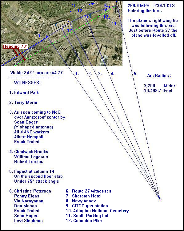
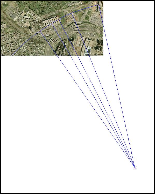
Blue flight path is the NoC one.
Green flight path is the officially endorsed SoC one.
Both flight paths were up to the FDR's last fully readable (by the NTSB) data block, at a steady heading of 070°, which is also an identical 60.25° true north heading.
That last data block contained the latitudinal and longitudinal positions that indicated a position just south of the Sheraton Hotel's southern facade.
That's just under my cipher 7 in my below drawing.
We do not have ANY officially endorsed further positional data offered by the NTSB investigators, only 4 seconds of further data extracted by Warren Stutt, an Australian IT man who has no former experience with officially decoding recovered FDR data, as he admits himself. He used a home made FDR data extraction program he wrote himself. The NTSB has never reacted on mails he send to them that their decoding technique must have a bug, since he found 4 extra seconds of blocks with more and more missing data, but still with positional data.
Those are the four missing positional data seconds it took the plane to cover that slight NoC arc flown from below the Sheraton Hotel (the last official NTSB position) up to impact.
I have extensive experience as explained in my 9/11 Watergate thread, that decoding FDR data and especially positional data, can be very tricky. You have to use various decoding techniques and math to at last end up with the real D 26 departure gate for AA 77 at Dulles International Airport.
So I expect that the same problems will arise when decoding the last flight seconds for AA 77 its FDR. Many corrections will have to be implemented to arrive at the exact positions on a map. Just as I found out for the beginning part of AA 77 its flight, namely the taxiing to the runway part of the flight. When you used the original lat. and long. data, the planes position on a Dulles Airport map was offset for hundreds of meters, and took off from a field beside the runway, that's why you know that you have to use corrections to arrive at the real-time positions of the plane at Dulles.
This is the NoC (blue) and SoC (green) flight paths drawing, both at a steady 070° heading up to a spot south of the Sheraton Hotel, where the NTSB stopped providing positional data from the FDR.
Note that the green, SoC line does not fit the eye witnesses at all :
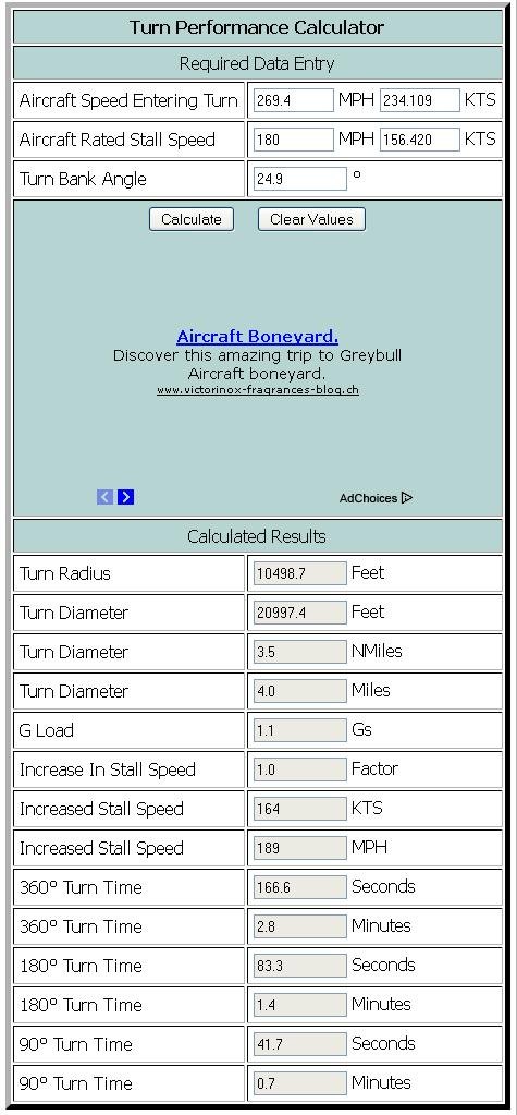
CALCULATION done in the online Turn Performance Calculator :
files.abovetopsecret.com...
It's quite easy to give hundreds of slightly different bank angles at slightly different speeds in slightly different turns and with slightly different arc radii for Flight AA 77, which all will cover all the known North of CITGO gas station witnesses their reported positions within acceptable error ranges, and which all will lead to AA 77 still impacting the west wall of the Pentagon at its second floor slab height, and near or at facade-column number 14.
But all these turns and radii will never ever follow a flight path like the officially pushed South of CITGO gas station trajectory. Which is a straight attack path, under a 42° angle to the normal of the Pentagon's west wall.
Which should also be, according to the data found in the recovered FDR, a 60.25° true north straight flight path.
The problem with that is, that the recovered FDR stopped giving data 4 seconds before impact. And that was at a spot just south of the Sheraton Hotel's southern facade.
Here's a drawing I remembered I found in the Purdue University animation files texts :
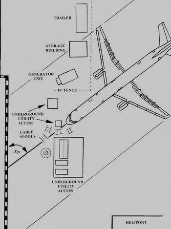
1. As you know by now, I do not believe anyone at first sight, so I checked that SoC impact angle depicted in the above drawing.
It's not 52°, but exactly 55°.
Which is by far not the 42° impact angle advocated by the ASCE Pentagon Building Performance Report, and from then on taken over by all official institutions and thus also by all debunkers of the real, true 9/11-history facts.
2. I also checked the position of that generator unit, which we always have called the generator trailer. That position is not even the end position of it after impact, it is depicted as far too far pushed around (It is photographed just after impact shifted around at about 45° max to the long fence). That generator trailer unit stood in fact exactly parallel to the fence, just as the other depicted trailer and that storage building, at the moment in flight of that plane which is depicted in the above position. Before it passed over that area.
3. The short fence is positioned wrong, it stood meters back to the south (upwards to the top of the drawing), and lead in reality towards that small protruding piece of the west wall facade.
4. Do yourself a favor, and draw a line through the impact point of that nose cone, under a real angle of 42°. Observe where the body of the plane should be drawn in reality.
And realize again, that not one guide rail under that wing could have made a gouge, without causing the right jet engine to fully impact at the side panel of that generator trailer unit.
Which would have obliterated that whole unit. But we see it still standing quite unharmed in all photo's shot within minutes after plane impact at the west wall.
5. I'll do you all a favor and draw that 42° attack angle line myself. Here it is, quite disturbing don't you think? It does not fit the 5 downed light poles at all. So, I hear the debunkers already : Then that 42° conclusion of the ASCE report must be false.
Well, one slight problem with that is that you need that 42° angle according to the ASCE guys, to construct a flight and internal damage path which leads through the 5 downed light poles, column 14 and ends at the "exit hole" in the C-ring corridor.
Which, as you can see below, is total humbug.
So, I measured that SoC attack angle which really runs through the 5 downed light poles, and you know what? It has an 52° angle, just as is typed inside the above Purdue drawing, which was in fact a 55° angle.
Can you still follow all deceptions laid upon you by all these early officially appointed 9/11 investigators from ASCE, Purdue University, NTSB who decoded the AA 77 its FDR, and the RADES radar mapping team which concluded that there were two final positions in front of the west wall which their radars recorded, one just before impact at a NoC position, and one just after impact (impossible) at a SoC position..? I have those photo's from the two radar recordings of AA 77 its position put up here below this following map :
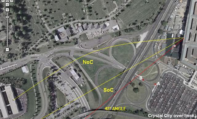
This is the last radar return at a NoC position recorded by the RADES team just moments before impact :
And this is the impossible SoC position radar return recorded by the RADES team just AFTER the impact :
This is another drawing, but now from the ASCE Pentagon Building Performance Report :
1. Notice please, that the impact angle depicted as 42° is in fact 46°. Check it with your graduated arc.
Most officially revealed material regarding 9/11 is riddled with these kind of HUGE DECEPTIONS which already should make you VERY AWARE of the many lies brought upon you by deceptive US government institutions.
By the way, many other western governments are just as guilty, since they could know just as easily as I, how one can find all these GLARING discrepancies in the officially pushed 9/11 history, which is obviously not the real and truthful history of that day.
And I will keep working relentlessly to make you aware of that and to unearth the true history.
2. Notice also that if the plane followed the depicted flight path and angle, its right wing's jet engine would have cut through that generator as butter, and the whole generator would have been obliterated. Just check the height of the nose cone impact point at the second floor slab on column 14. And the height of the generator trailer.
If that right jet engine's bottom has passed freely over the trailer's roof, the plane was in a ridiculous sharp vertical attack angle which does not cope with all known observations at all.
I hope you understand that the plane's nose cone in that case was much higher above that generator trailer, than the height of the second floor slab, where the ASCE report says it impacted.
3. Notice also that if the jet engine would have missed the trailer, in other words would have passed above its generator section's roof, there can not be ONE part of that right wing that could have made the so clearly photographed gouge in its roof, since all 4 guard rails that stick out from under that right wing are much higher placed then the bottom of the right jet engine.
Conclusion : that plane flew much lower, under a vertical attack angle of 8.18° and a horizontal attack angle of much more than 42° as the ASCE report touts, according to that roof-gouge made by one of the guide rails under that right wing at an horizontal angle of about 62°, and its right jet engine must have past beside that whole generator trailer. To offer room for the guide rail to cut at an 62° angle through the roof of that generator trailer.
4. Notice also that if you draw a straight line in above map, from column 14 under a real angle of 42°, that it ends not at the "exit hole", but many meters to the right of it.
Blue flight path is the NoC one.
Green flight path is the officially endorsed SoC one.
Both flight paths were up to the FDR's last fully readable (by the NTSB) data block, at a steady heading of 070°, which is also an identical 60.25° true north heading.
That last data block contained the latitudinal and longitudinal positions that indicated a position just south of the Sheraton Hotel's southern facade.
That's just under my cipher 7 in my below drawing.
We do not have ANY officially endorsed further positional data offered by the NTSB investigators, only 4 seconds of further data extracted by Warren Stutt, an Australian IT man who has no former experience with officially decoding recovered FDR data, as he admits himself. He used a home made FDR data extraction program he wrote himself. The NTSB has never reacted on mails he send to them that their decoding technique must have a bug, since he found 4 extra seconds of blocks with more and more missing data, but still with positional data.
Those are the four missing positional data seconds it took the plane to cover that slight NoC arc flown from below the Sheraton Hotel (the last official NTSB position) up to impact.
I have extensive experience as explained in my 9/11 Watergate thread, that decoding FDR data and especially positional data, can be very tricky. You have to use various decoding techniques and math to at last end up with the real D 26 departure gate for AA 77 at Dulles International Airport.
So I expect that the same problems will arise when decoding the last flight seconds for AA 77 its FDR. Many corrections will have to be implemented to arrive at the exact positions on a map. Just as I found out for the beginning part of AA 77 its flight, namely the taxiing to the runway part of the flight. When you used the original lat. and long. data, the planes position on a Dulles Airport map was offset for hundreds of meters, and took off from a field beside the runway, that's why you know that you have to use corrections to arrive at the real-time positions of the plane at Dulles.
This is the NoC (blue) and SoC (green) flight paths drawing, both at a steady 070° heading up to a spot south of the Sheraton Hotel, where the NTSB stopped providing positional data from the FDR.
Note that the green, SoC line does not fit the eye witnesses at all :
CALCULATION done in the online Turn Performance Calculator :
files.abovetopsecret.com...
It's quite easy to give hundreds of slightly different bank angles at slightly different speeds in slightly different turns and with slightly different arc radii for Flight AA 77, which all will cover all the known North of CITGO gas station witnesses their reported positions within acceptable error ranges, and which all will lead to AA 77 still impacting the west wall of the Pentagon at its second floor slab height, and near or at facade-column number 14.
But all these turns and radii will never ever follow a flight path like the officially pushed South of CITGO gas station trajectory. Which is a straight attack path, under a 42° angle to the normal of the Pentagon's west wall.
Which should also be, according to the data found in the recovered FDR, a 60.25° true north straight flight path.
The problem with that is, that the recovered FDR stopped giving data 4 seconds before impact. And that was at a spot just south of the Sheraton Hotel's southern facade.
Here's a drawing I remembered I found in the Purdue University animation files texts :
1. As you know by now, I do not believe anyone at first sight, so I checked that SoC impact angle depicted in the above drawing.
It's not 52°, but exactly 55°.
Which is by far not the 42° impact angle advocated by the ASCE Pentagon Building Performance Report, and from then on taken over by all official institutions and thus also by all debunkers of the real, true 9/11-history facts.
2. I also checked the position of that generator unit, which we always have called the generator trailer. That position is not even the end position of it after impact, it is depicted as far too far pushed around (It is photographed just after impact shifted around at about 45° max to the long fence). That generator trailer unit stood in fact exactly parallel to the fence, just as the other depicted trailer and that storage building, at the moment in flight of that plane which is depicted in the above position. Before it passed over that area.
3. The short fence is positioned wrong, it stood meters back to the south (upwards to the top of the drawing), and lead in reality towards that small protruding piece of the west wall facade.
4. Do yourself a favor, and draw a line through the impact point of that nose cone, under a real angle of 42°. Observe where the body of the plane should be drawn in reality.
And realize again, that not one guide rail under that wing could have made a gouge, without causing the right jet engine to fully impact at the side panel of that generator trailer unit.
Which would have obliterated that whole unit. But we see it still standing quite unharmed in all photo's shot within minutes after plane impact at the west wall.
5. I'll do you all a favor and draw that 42° attack angle line myself. Here it is, quite disturbing don't you think? It does not fit the 5 downed light poles at all. So, I hear the debunkers already : Then that 42° conclusion of the ASCE report must be false.
Well, one slight problem with that is that you need that 42° angle according to the ASCE guys, to construct a flight and internal damage path which leads through the 5 downed light poles, column 14 and ends at the "exit hole" in the C-ring corridor.
Which, as you can see below, is total humbug.
So, I measured that SoC attack angle which really runs through the 5 downed light poles, and you know what? It has an 52° angle, just as is typed inside the above Purdue drawing, which was in fact a 55° angle.
Can you still follow all deceptions laid upon you by all these early officially appointed 9/11 investigators from ASCE, Purdue University, NTSB who decoded the AA 77 its FDR, and the RADES radar mapping team which concluded that there were two final positions in front of the west wall which their radars recorded, one just before impact at a NoC position, and one just after impact (impossible) at a SoC position..? I have those photo's from the two radar recordings of AA 77 its position put up here below this following map :
This is the last radar return at a NoC position recorded by the RADES team just moments before impact :
And this is the impossible SoC position radar return recorded by the RADES team just AFTER the impact :
This is another drawing, but now from the ASCE Pentagon Building Performance Report :
1. Notice please, that the impact angle depicted as 42° is in fact 46°. Check it with your graduated arc.
Most officially revealed material regarding 9/11 is riddled with these kind of HUGE DECEPTIONS which already should make you VERY AWARE of the many lies brought upon you by deceptive US government institutions.
By the way, many other western governments are just as guilty, since they could know just as easily as I, how one can find all these GLARING discrepancies in the officially pushed 9/11 history, which is obviously not the real and truthful history of that day.
And I will keep working relentlessly to make you aware of that and to unearth the true history.
2. Notice also that if the plane followed the depicted flight path and angle, its right wing's jet engine would have cut through that generator as butter, and the whole generator would have been obliterated. Just check the height of the nose cone impact point at the second floor slab on column 14. And the height of the generator trailer.
If that right jet engine's bottom has passed freely over the trailer's roof, the plane was in a ridiculous sharp vertical attack angle which does not cope with all known observations at all.
I hope you understand that the plane's nose cone in that case was much higher above that generator trailer, than the height of the second floor slab, where the ASCE report says it impacted.
3. Notice also that if the jet engine would have missed the trailer, in other words would have passed above its generator section's roof, there can not be ONE part of that right wing that could have made the so clearly photographed gouge in its roof, since all 4 guard rails that stick out from under that right wing are much higher placed then the bottom of the right jet engine.
Conclusion : that plane flew much lower, under a vertical attack angle of 8.18° and a horizontal attack angle of much more than 42° as the ASCE report touts, according to that roof-gouge made by one of the guide rails under that right wing at an horizontal angle of about 62°, and its right jet engine must have past beside that whole generator trailer. To offer room for the guide rail to cut at an 62° angle through the roof of that generator trailer.
4. Notice also that if you draw a straight line in above map, from column 14 under a real angle of 42°, that it ends not at the "exit hole", but many meters to the right of it.
It's advisable to also read this thread by me (8 pages now), titled :
The Generator-trailer its cabin roof-gouge is made by a NoC flying AA 77.
www.abovetopsecret.com...
And this one too, where I embarked with a stiff conviction that Flight AA 77 departed from another gate at Dulles than the government institutions like the NTSB and the FBI interviews of Dulles gate personnel told us.
To end up with the fact that I had to admit that the real departure gate was D 26, just as the NTSB and those FBI interviews told us :
At last, THE "WATERGATE" OF 9/11 :
www.abovetopsecret.com...
There are a few more interesting ones, but I will post those after the distracted ones have arrived.
Always double-check, so here's another Turning Performance (Bank Angle) Calculator :
www.pilotoutlook.com...
When you enter the same data I used in my above OP in this one, you end up with the same figures as the above posted calculator came up with :
So we may again conclude that my proposed particular NoC flight path for AA 77 is easily possible.
PS : the link to the turn calculator shown in the OP is :
www.csgnetwork.com...
www.pilotoutlook.com...
When you enter the same data I used in my above OP in this one, you end up with the same figures as the above posted calculator came up with :
Turning Performance (Bank Angle) Calculator
Formula:-
radius = speed2 / (gravity x tangent (bank angle))
time = 2 x PI x speed / (gravity x tangent (bank angle))
where: speed=feet per second (fps = mph x 1.47), mph to fps conversion is done for you on form below
gravity =32.2 fps
SPEED MPH : 269.4 mph.
BANK ANGLE: 24.9°
Turn Size :
RADIUS: 10498.7 feet. (3200.0037 meters, 3.2 KM)
DIAMETER: 20997.4 feet. (6400.0075 meters; 6.4 KM)
TIME FOR 360 DEG TURN IN SECONDS: 167 seconds.
IN MINUTES: 2.78 minutes.
So we may again conclude that my proposed particular NoC flight path for AA 77 is easily possible.
PS : the link to the turn calculator shown in the OP is :
www.csgnetwork.com...
edit on 7/6/12 by LaBTop because: Added turn calculator link.
Here you go again... There are several errors, but I stopped at the Turn Radius. Your turn radius is GROSSLY WRONG. It's not even close.
No need to go further than that....
You need to pursue another hobby, you're not very good at this one...
You need to pursue another hobby, you're not very good at this one...
reply to post by Reheat
That's clearly a worthless post, identical to many more before. You have never offered any explanation at all.
I am waiting.
That's clearly a worthless post, identical to many more before. You have never offered any explanation at all.
I am waiting.
Ok, so if it was NoC, then when did the secret stealth agents run out and knock over the lamp posts, damage the taxi, and plant the eyewitnesses that
said they saw the plane clip lamp posts, and then repair the interior of the Pentagon and rearrange it to line up with the SoC line?
Remember, this all had to be done in front of hundreds of gawkers on the highways and byways, and let us not forget the folks in traffic, first responders and the newscrews.
I'm sure you will find a good excuse for that.
Remember, this all had to be done in front of hundreds of gawkers on the highways and byways, and let us not forget the folks in traffic, first responders and the newscrews.
I'm sure you will find a good excuse for that.
edit on 6/7/2012 by GenRadek because: edit to add
Originally posted by LaBTop
reply to post by Reheat
That's clearly a worthless post, identical to many more before. You have never offered any explanation at all.
I am waiting.
Speaking of worthless..... All of your garbage is a prime example. You're pretending to be an expert, yet you don't have a clue about what you're doing. I have told you REPEATEDLY from the very beginning that your turn radius is not correct. You have repeatedly argued as if you knew better. You also don't know how to make a turn fit within a properly calculated turn radius.
You have incessantly refused to follow Morin's description of what he saw, but instead tried to make your (it's actually not yours it CIT crap) path fit with your concocted delusion so that it all fits..
You next error is the stall speed of a B-757. If you can't get a fixed number correct how in the hades can you come up with all of this concocted BS and expect anyone to accept anything you say.
Go find another hobby, you suck at this one...
Also, your arc. That would mean the plane was in a right wing down left wing up bank. Yet, Mr. Hemphill stated the plane flew over his position with
a left wing down right wing up bank. How can a plane be turning to the right if it has its wings banked left? it is no fighter jet either.
reply to post by GenRadek
My favorite and one that cracks me up every time I think about it is the guy "they" persuaded to go up in a cherry picker and meticulously prune with a chain saw that engine shaped gouge in the top of that tree... That took some practice to get it just right. I can imagine there are trees all around Arlington on which he practiced to get it just right.
He wouldn't have needed practice to get the damage to the radio antenna just right, but that tree took some real artistic talent and practice!
Originally posted by Reheat
Here you go again... There are several errors, but I stopped at the Turn Radius. Your turn radius is GROSSLY WRONG. It's not even close. No need to go further than that....
You need to pursue another hobby, you're not very good at this one...
Originally posted by Reheat
reply to post by LaBTop
You're waiting for what?
For this calculation you are seemingly incapable of, or unwilling to perform, to show that my arc radius length is perfectly right :
For my really interested readers :
Start with blowing up my viable arc map as big as you can in your browser on your monitor, by using the Ctrl/+ keys.
View then my second (the SoC) radar return photo in my OP.
Note that there are two length given in the bottom left. A 200 meter and a 500 feet one.
I measured that 200 meter length to be 4.0 cm. And the length of all 8 Navy Annex wing roofs as 6.0 cm.
4.0 : 200 = 6.0 : X
4.0 X = 1200
X = 1200 / 4.0 = 300 meters length of the Navy Annex roofs.
Now I measured in my max blown up 'Viable 24.9° turn arc for Flight AA 77' drawing in my OP:
The length of the Annex its 8 white roofs total length = 5.50 cm which is 300 meters as now known.
My arc radius length is 58.80 cm = X meters.
5.50 : 300 = 58.80 : X
5.50 X = 300 x 58.80
X = 17640 / 5.50 = 3207.27 meters.
I used 3200 meters to fill-in as my arc radius, in the online Aircraft Turn Information Calculator you provided in your own signature-link. That few 7.27 extra meters fall away against the intrinsic errors in the measurements.
Which signature-link's inherent text is no more than a pathetic joke, since no one ever believed your impossible proposal for a return from a NoC path to the official SoC path within that short distance, by performing a fast but totally impossible right-left bank, to make the NoC path eventually working inside the so defended by you, SoC path.
You proved to yourself that the NoC path can't ever be combined with the officially proposed SoC path.
And you gave no further arguments to counter all these video taped eyewitnesses who all saw with their own eyes how AA 77 flew north of the CITGO gas station's canopy.
Btw, 3200 meters = 3200 meters : 0.3048 feet = 10.498 feet.
Any contra-arguments?
edit on 8/6/12 by LaBTop because: (no reason given)
Originally posted by GenRadek
Also, your arc. That would mean the plane was in a right wing down left wing up bank. Yet, Mr. Hemphill stated the plane flew over his position with a left wing down right wing up bank. How can a plane be turning to the right if it has its wings banked left? it is no fighter jet either.
Do you even realize that the position of Mr Hemphill in his far northernly office at the top floor of the 8th Annex wing (which was lower than the 7th Annex wing) indicates that the plane he saw was not a SoC STRAIGHT flying plane?
Look it up again, what did he say where he saw the plane when it started crossing his eyesight?
For my still doubting readers :
Title : A message for Frank Legge regarding Albert Hemphill's evidence.
www.911oz.com...
Note especially the photo with the straight blue line into the Pentagon, with the text line "Line of sight to impact point".
Note the words "Line of sight" !
It's not the plane's flight path, which he also cleared up by his words that the plane was flying a left bank :
Your quoted words : ""Mr. Hemphill stated the plane flew over his position with a left wing down right wing up bank. How can a plane be turning to the right if it has its wings banked left? ""
Thus, that plane flew in a TURN over the Navy Annex roofs already, which also nullifies the SoC theory : ""Hemphill: right over the top"" when he first saw it, and NOT STRAIGHT !!!!
And then it changed to a right curve again, obviously, since all the eyewitnesses said so, even Hemphill states it flew over the CITGO roof........
This was btw posted by KP from New Zealand, who is the Admin at the PfTruth forums.
He acted aggressively after he found out that I proposed a NoC impact, not as a friend when I posted there, and he and Balsamo first moved my big thread out of the main forums there, then they banned me and they both still vehemently defend the fly-over theory.
But this is still holding water :
You can call it cherry picking, I call it asking questions of a witness and listening to the answers.
Here is part of the transcript of Craig's call with Hemphill taken from
www.citizeninvestigationteam.com...
Ranke: are you saying he was off to the side of the Navy Annex, or ...
Hemphill: yeah, he would have been over my right shoulder
Ranke: but you saw the fuselage appear, was it directly over the top of the Navy Annex or ...
Hemphill: right over the top
So Hemphill believes the plane flew right over the top of the Navy Annex - over his right shoulder because his office was towards the north end of the Annex.
Ranke: when you saw it pass the gas station, which side of the gas station was it on, was it on the Arlington Cemetery or north side or else perhaps the south side, the other side?
Hemphill: you know it's hard to say, it looked like it went right over the top .....
Ranke: would you say, if you had to say it was leaning towards one side or the other of the gas station, perhaps a portion of the plane, did it look directly over the top or what do you think?
Hemphill: yeah, I'd say more towards the cemetery side.
You can listen to the interview again - Hemphill has no problem recalling the gas station and believes it went pretty much straight over the top of the gas station, slightly to the Arlington Cemetery side of the gas station. This isn't cherry picking, this is his evidence and it corroborates the witnesses at the gas station, the witnesses at in the Arlington Cemetery maintenance buildings car park and Sean Boger at the Pentagon. Given the line of sight that Hemphill had, if the plane flew on the "official path" there is no way he would mistakenly believe that it flew over the gas station. He also would not mistakenly believe that it flew over the Navy Annex.
Read the whole Australian thread there.
Do you also realize that if he saw a left banking plane, he also did not see a straight steady 070° heading flying plane?
Which makes the FDR's last 4 recorded seconds by Warren Stutt moot, again.
And thanks again for helping me proving my points by getting Albert Hemphill into the discussion.
Btw, where are you guys with addressing the meat of the matter in my OP.
Only the same repeated insults and "making fun of" distractions from my OP. As usual.
Originally posted by GenRadek
Ok, so if it was NoC, then when did the secret stealth agents run out and knock over the lamp posts, damage the taxi, and plant the eyewitnesses that said they saw the plane clip lamp posts, and then repair the interior of the Pentagon and rearrange it to line up with the SoC line?
Remember, this all had to be done in front of hundreds of gawkers on the highways and byways, and let us not forget the folks in traffic, first responders and the newscrews.
I'm sure you will find a good excuse for that.edit on 6/7/2012 by GenRadek because: edit to add
The lamp poles were already downed in the night, nobody would have noticed it at such a high security facility. So now you know who for sure were involved, important parts of the military, since they had to safely clear the premises during that nightly black operation.
The taxi driver even said in his last interview with CIT, when driving together with them along Route 27 in the night, that the real accident occurred somewhere beside the last part of that huge stone wall keeping the grounds of the Arlington Cemetery from falling on Route 27. Go listen again to that famous CIT video interview.
Which is exactly where I proposed that AA 77 flew over Route 27, just as you can see in the Italian blogger animation of a photo taken from the north in the south going lane, with the inserted 757 passing near perpendicular over Route 27.
And that first photo shooting photographer admitted later that that was exactly what he saw on 9/11.
It is however more logical that he was in with the planners, and that the already damaged parts of that pole were brought to lay down near the overpass bridge and that the piece that should have speared his windshield was placed on the road by those two clearly Agency guys photographed guarding him all the time. His windshield was probably already broken in advance with a piece of that broken lamp pole which was there after laid beside the bridge.
Would you be so kind to list here ""the eyewitnesses that said they saw the plane clip lamp posts.""
There is up till now not one of them who stood up against firm scrutiny, they all retracted that they saw such thing, most of them changed their words, or admitted to have added them since they were aware from day one (9/11) of the media coverage of those 5 downed lamp poles. It's called "nicing-up" a story line.
""and then repair the interior of the Pentagon and rearrange it to line up with the SoC line?""
I told you now so many times already that a few minutes after the first photographer at the scene started to take his famous pictures, he caught a huge white-hot explosion spitting out of the entrance hole in the west wall.
The plane entered the building at a much bigger angle than the ASCE promoted 42°, more like 62°, and was stopped mostly by all the reinforcement measures in the newly renovated portion of WEDGE 1.
Even the ASCE engineers admitted that the plane did not get further in the building than its own initial length.
All the rest of the internal damage does not fit the generator roof-gouge trajectory indication of a horizontal attack angle of about 62°.
It also does not fit any of the NoC eyewitnesses.
The CITGO video also has a suspicious bright reflective flash at its north side in it, exactly when AA 77 must have passed northernly of its northern canopy.
You even see clearly that sergeant Lagasse is filling up his gas tank of his Pentagon Police cruiser when that occurs. Immediately there after he ran around his car to the driver side, radioed in that the Pentagon was hit and he sped backwards out of the CITGO grounds.
Originally posted by Reheat
Originally posted by LaBTop
reply to post by Reheat
That's clearly a worthless post, identical to many more before. You have never offered any explanation at all.
I am waiting.
Speaking of worthless..... All of your garbage is a prime example. You're pretending to be an expert, yet you don't have a clue about what you're doing. I have told you REPEATEDLY from the very beginning that your turn radius is not correct. You have repeatedly argued as if you knew better. You also don't know how to make a turn fit within a properly calculated turn radius.
You have incessantly refused to follow Morin's description of what he saw, but instead tried to make your (it's actually not yours it CIT crap) path fit with your concocted delusion so that it all fits..
You next error is the stall speed of a B-757. If you can't get a fixed number correct how in the hades can you come up with all of this concocted BS and expect anyone to accept anything you say.
Go find another hobby, you suck at this one...
And I have repeatedly told you to prove with solid calculations, as I did, why you are so sure that my turn radius is not correct. I just proved you utterly wrong on that subject.
Please explain also this snidely remark of you :
""You also don't know how to make a turn fit within a properly calculated turn radius.""
So I can counter just as well your eventual arguments.
Terry Morin's last phone interview made it totally clear, he stood 10 feet within the space between the 4th and 5th wing of the Navy Annex. Do your best to prove me wrong, we can hear him tell us the exact spot where he saw the plane when looking up. Stop repeating this kind of untruest dis-info.
""You next error is the stall speed of a B-757.""
Well, than you are the deluded one, since I got the stall speed of a Boeing 757-200 from a post by ProudBird, who actually flew these exact birds. He will know these kind of important flight data by heart, don't you think so?
As you can see ProudBird chose a safe stall speed of 180 MPH, which is a bit more than the 'Clean' stall speed (no flaps or undercarriage) which is in the region of 150 Knots (172.650 MPH).
answers.yahoo.com...
Best Answer - Chosen by Voters
Heres all the info I've got....Takeoff (rotation) speed at a weight of 108, 305kg is 140 knots (160 MPH) (V1 is at 130 Knots). Landing speed is 160 Knots Indicated air speed to give plenty of speed in event of go around.. Rate of climb, the aircraft usually performs in the region of 1,200 Feet per minute (FPM) to a 2,500 FPM. Stall speed with the aircraft 'dirty' so all flaps and undercarrige out is 107 Knots. Pilots tend to fly 30% greater than the stall speed so minum 140Knots at landing.
'Clean' stall speed (no flaps or undercarrige) is in the region of 150 Knots.
I get more and more the impression that you randomly throw in untrue dis-info, just to wreck my threads.
I just proved you wrong on your accusation that my arc radius was blatantly false, now it turns out that your accusations are the real blatantly false ones.
Please perform better, or leave my threads alone.
Originally posted by LaBTop
And I have repeatedly told you to prove with solid calculations, as I did, why you are so sure that my turn radius is not correct. I just proved you utterly wrong on that subject.
Your calculated turn radius for your arc is about % 40 larger than it actually is... I've been telling you this for months (perhaps even over a year). If that's not plain enough I don't know how to make it any plainer. You need to figure out why it's wrong. I'm not willing to help you with that at all.. I don't know the length of the Navy Annex and don't care. I am using proper measurement tools to calculate a turn radius and I know how to do it. You obviously don't....
Originally posted by LaBTop
Please explain also this snidely remark of you :
""You also don't know how to make a turn fit within a properly calculated turn radius.""
So I can counter just as well your eventual arguments.
On more than one occasion you have calculated turn parameters with a larger turn radius than shown by your own mis calculated radius... I'm simply not willing to go search through your garbage to find it, so find it yourself...
Originally posted by LaBTop
Terry Morin's last phone interview made it totally clear, he stood 10 feet within the space between the 4th and 5th wing of the Navy Annex. Do your best to prove me wrong, we can hear him tell us the exact spot where he saw the plane when looking up. Stop repeating this kind of untruest dis-info.
Show me proof that the person the CIT lying morons interviewed was Terry Morin. You can't. All you are doing is taking the word of proven liars... Even so, what he said in that supposed second interview still does not fit with your path...
Originally posted by LaBTop
""You next error is the stall speed of a B-757.""
Well, than you are the deluded one, since I got the stall speed of a Boeing 757-200 from a post by ProudBird, who actually flew these exact birds. He will know these kind of important flight data by heart, don't you think so?
The freaking stall speed of a Boeing 757 in a clean configuration is 160 Knots. Prove that Proudbird said anything differently.
If you work at it long enough you might eventually figure out where you've made the error in measuring the turn radius of that arc... Use proper tools and you might eventually get it right. Keep doing it the way you're doing it is not the solution...
Find a new hobby, you suck at this one....
Originally posted by LaBTop
Any contra-arguments?edit on 8/6/12 by LaBTop because: (no reason given)
Yea, your turn radius is about % 40 too large.
With the kind of garbage you've written so far, you fail miserably to set any facts straight... If you calculate the wrong turn radius for the arc
you've drawn, no calculator or no formula is going to help... Until such time that you calculate a correct turn radius for that arc you will
continue your delusion...
It's simply a regurgitation of some of your previous garbage in order to prove some kind of conspiracy. It is a totally ridiculous proposition on it's face. You are mostly using CIT's debunked crap as your premise for argument in the first place.
In fact, CIT's premise of a fly-over makes more sense than this imaginary delusion. Why in the world a conspiracy plan would include all of the obvious damage path evidence, yet fly a different path to accomplish the goal of crashing an aircraft into the building perhaps only those who promote this type of crap know. If "they" did not intend a different path then how in the heck was all of that obvious damage accomplished on a spur-of-the-moment basis with thousands of people watching both in person and TV cameras all over the place within moments of the crash... All of that is amazing capability that "they" have for which there is no rational explanation... Furthermore it would accomplish the same goal to fly the path shown by the damage leading up to the building, so why fly a different path and have idiots question as you and you're ilk persist in doing in order to satisfy your conspiracy delusions...
You keep repeating the phrase that I said an NOC path was impossible just as CIT has done... What I actually said and still say is that an NOC path that complies with the primary witness statements is impossible... You have deliberately and carefully chosen the only path and speed that is even close to being reasonable. Yet you still have the MAJOR problem that NO ONE, NOT EVEN ONE witness described the large bank angle necessary to fly the path you've drawn. Your calculated turn radius is wrong resulting in a shallower bank angle than is necessary to fly the arc you've drawn. That is a FACT and if you'll calculate a proper radius for that arc you'll eventually discover that I am correct. I am simply not willing at this point to obtain and draw a diagram large enough to show the distances involved for the proper radius calculation. Your measurements are WRONG no matter how many times you post them...
Originally posted by Reheat
Originally posted by LaBTop
Any contra-arguments?edit on 8/6/12 by LaBTop because: (no reason given)
Yea, your turn radius is about % 40 too large.
Show me your calculations to refute mine, not your avoidance of the subject by hoping the reader will believe your online credibility.
I showed you my calculations for my turn radius, do us a favor and show me were I made a miscalculation in my above post.
You can't, because it's perfectly right calculated.
With an error margin of 7 meters on a radius of 3200 meter....... Can you do better ?
I repeat, I used your OWN POSTED Turn Performance Calculator.
From your own signature link ( Debunking the North of Citgo Theory ) that you advised yourself to us, to use, because of its easy handling.
Which I gladly admit, other sites use it too, as I showed you in one of my above posts :
--- This is an easy turn calculator to use once the required turn radius is determined or alternatively a turn radius can be derived by plugging in proposed numbers. This calculator may also be used to check the numbers in the chart.
Others are encouraged to post this work on other web sites or link to the pages. In addition, anyone qualified to do so is free to examine this work. I claim no copyright to the material. ---
I have objectively examined your work, and you did not pass any truly argumentative NoC flight path test.
You did not offer any contradictions at all, you just tried to make fun of the witnesses, who swear to have seen A 77 fly north of the CITGO canopy.
This is an excerpt of the Frank Legge, (B.Sc.(Hons.), Ph.D.) and Warren Stutt, ( B.Sc.(Hons.) Comp. Sci.), January 2011 thesis in PDF form, that said
that additional seconds were decoded from the recovered AA 77 its FDR by Warren Stutt.
They said at the time of publication in Jan 2011 that the bolded by me data information in the following excerpt could be collected from an additional amount of seconds (6 or 8) on top of the official NTSB decoded part of the FDR.
Title : Flight AA77 on 9/11: New FDR Analysis Supports the
Official Flight Path Leading to Impact with the Pentagon
www.journalof911studies.com...
I had a long discussion with ProudBird about the Captain's Clock data, which I proved to be set correctly by both pilots after engine start-up.
I have compared the times from the CVR, the FAA clocked transcripts of the Air Controllers communications with the AA 77 cockpit, and there was no discernible discrepancy between ground-based times and times recorded in the plane.
My conclusion, based on lots of evidence : the Captain's Clock in the aircraft functioned correctly, all the time.
Fig. 1. Final track through light poles to the Pentagon.
The external attack angle of the depicted plane in this fig. 1, is 55° to the west wall. Check it yourself with a graduated arc. Blow-up/enlarge the above figure in your browser again by using repeatedly the key-combination CTRL/+ to the max enlargement.
The internal damage angle from C-ring hole (yellow-orange block at the end of that big shining-through whitish arrow, covering the wingspan of that 3 times shown 757-200) to column 14 where the nose cone impacted according to the ASCE Report, is easily measurable with a ruler and is depicted in this figure 1 as a 48° angle.
Column 14 in this above fig 1 is the fifth red dot counted from the bottom part of the E-ring west wall facade.
If you do not trust me for that, have a look at one of my copied ASCE drawings :
I conclude from this external flight path its angle of 55°, that the ASCE Pentagon Building Performance Report conclusion that the internal horizontal damage path is depicted AND concluded by them as a 42° attack angle for the impacting plane, is humbug.
First, since the measurable internal damage angle is not 42°, but 48°, use your graduated arc.
Second, since there would be a huge difference in angles between the internal and external paths at the impact point at column 14, namely a difference of 13°.
Of course they had to conclude to a 42° internal damage angle, otherwise that line would not fit the 5 downed light poles snugly, but would show that those light poles were artificially downed the night before. Check it yourself with the real 48° angle from the above drawing, see where it leads through the 5 light poles.......
Or the external horizontal flight path angle is humbug.
One of both, or both two of them have to be false.
They do not fit smoothly onto each other. There is a knick of 7° at the impact point at column 14, if you adhere to both, largely differing, attack angle conclusions in fig 1 that originally came from the ASCE Report. Just as the above big drawing, it shows internal angle of 48° and an external angle of 55°.
Just 2 or more degrees attack angle difference ends up already with missed downed light poles.
They showed us that the wing tips cut some of them down..... If those two wing tips shift a few meters to the right or left, they miss already one or more of those poles.
They had to enforce in our minds that 42° angle through publication of that ASCE Report, to be able to fit all those specific 5 poles....
And if you still believe that that C-ring wall "exit hole" was made by a heavy plane part that did not flew all the way further to the other wall in that corridor between the C-ring and B-ring walls, but fell "dead" in front of, or just one meter out of that "exit hole", you should pay more attention to your physics books.
I showed in former posts years ago already that that hole bears full resemblance with the use of a wall-breaching unit, used by the military to quickly enter through an enemy's stronghold's blown up walls.
In fact it looks as a perfect copy of the photo of a wall-breaching unit's resulting hole I posted many times now already.
An additional effect of this fig.1 is that you can see that the generator trailer was placed tightly in the fence corner and with its longitudinal length parallel to the long fence around the contractors facilities area. Which fence ran perfectly parallel with the west wall.
They said at the time of publication in Jan 2011 that the bolded by me data information in the following excerpt could be collected from an additional amount of seconds (6 or 8) on top of the official NTSB decoded part of the FDR.
Title : Flight AA77 on 9/11: New FDR Analysis Supports the
Official Flight Path Leading to Impact with the Pentagon
www.journalof911studies.com...
Some time ago one of the authors, Warren Stutt, who independently received a copy of the FDR file as a result of his FOIA request, discovered more data at the end of the file which had not previously been decoded. He recently managed to decode the last frame and has made the information freely available.13 The file contains a vast amount of data, including the following essential information: the vertical acceleration every eighth of a second; longitudinal acceleration, roll angle and pitch every quarter of a second; air speed, ground speed, pressure altitude, radio height, heading and position every second; all finishing at points within the last second. The last time stated in the file is 9:37:49, which is in the 4th last subframe. Three more subframes were recorded, one second each, bringing the time of the last recording to 9:37:52, 6 or 8 seconds later than the two official times of impact. We do not assert that this accurately represents the time of impact as the clock in the aircraft may have been incorrect.
I had a long discussion with ProudBird about the Captain's Clock data, which I proved to be set correctly by both pilots after engine start-up.
I have compared the times from the CVR, the FAA clocked transcripts of the Air Controllers communications with the AA 77 cockpit, and there was no discernible discrepancy between ground-based times and times recorded in the plane.
My conclusion, based on lots of evidence : the Captain's Clock in the aircraft functioned correctly, all the time.
Fig. 1. Final track through light poles to the Pentagon.
The external attack angle of the depicted plane in this fig. 1, is 55° to the west wall. Check it yourself with a graduated arc. Blow-up/enlarge the above figure in your browser again by using repeatedly the key-combination CTRL/+ to the max enlargement.
The internal damage angle from C-ring hole (yellow-orange block at the end of that big shining-through whitish arrow, covering the wingspan of that 3 times shown 757-200) to column 14 where the nose cone impacted according to the ASCE Report, is easily measurable with a ruler and is depicted in this figure 1 as a 48° angle.
Column 14 in this above fig 1 is the fifth red dot counted from the bottom part of the E-ring west wall facade.
If you do not trust me for that, have a look at one of my copied ASCE drawings :
I conclude from this external flight path its angle of 55°, that the ASCE Pentagon Building Performance Report conclusion that the internal horizontal damage path is depicted AND concluded by them as a 42° attack angle for the impacting plane, is humbug.
First, since the measurable internal damage angle is not 42°, but 48°, use your graduated arc.
Second, since there would be a huge difference in angles between the internal and external paths at the impact point at column 14, namely a difference of 13°.
Of course they had to conclude to a 42° internal damage angle, otherwise that line would not fit the 5 downed light poles snugly, but would show that those light poles were artificially downed the night before. Check it yourself with the real 48° angle from the above drawing, see where it leads through the 5 light poles.......
Or the external horizontal flight path angle is humbug.
One of both, or both two of them have to be false.
They do not fit smoothly onto each other. There is a knick of 7° at the impact point at column 14, if you adhere to both, largely differing, attack angle conclusions in fig 1 that originally came from the ASCE Report. Just as the above big drawing, it shows internal angle of 48° and an external angle of 55°.
Just 2 or more degrees attack angle difference ends up already with missed downed light poles.
They showed us that the wing tips cut some of them down..... If those two wing tips shift a few meters to the right or left, they miss already one or more of those poles.
They had to enforce in our minds that 42° angle through publication of that ASCE Report, to be able to fit all those specific 5 poles....
And if you still believe that that C-ring wall "exit hole" was made by a heavy plane part that did not flew all the way further to the other wall in that corridor between the C-ring and B-ring walls, but fell "dead" in front of, or just one meter out of that "exit hole", you should pay more attention to your physics books.
I showed in former posts years ago already that that hole bears full resemblance with the use of a wall-breaching unit, used by the military to quickly enter through an enemy's stronghold's blown up walls.
In fact it looks as a perfect copy of the photo of a wall-breaching unit's resulting hole I posted many times now already.
An additional effect of this fig.1 is that you can see that the generator trailer was placed tightly in the fence corner and with its longitudinal length parallel to the long fence around the contractors facilities area. Which fence ran perfectly parallel with the west wall.
Title : Debunking the North of Citgo Theory
www.911myths.com...
It's basically an attempt by him through an impossible short, right-left banks turn, to return from a flight path north of the CITGO gas station (NoC), back to the official advocated SoC path.
Such an impossible flight path, you should particularly note, NOBODY ever advocated...!
He clearly based that fairy tale on his strong believe that the US government or its agencies will never lie to him. And thus he strongly holds to the SoC straight flight path as the only possible true flight path end. Because his governments institutions tell him so....
Up till now he triumphantly sig-links that text as if it truly is a solid debunking of the North of Citgo NoC flight path.
However, it is not at all what its title advocates, and its eventual deceptive influence on 9/11 forum readers should end, here and now.
Let's exchange arguments, and you, the reader may decide who is right or wrong.
His text in his sig-link shows not even a shimmer of a solid calculated attempt to prove the impossibility (in his eyes) of a real-time observed slightly curved NoC flight path of AA 77 by many witnesses (now 23), some of who expressed their certainty of a north of the CITGO gas station passing Flight AA 77 Boeing 757-200.
He can't prove it to be impossible. Never. Ever.
Because I proved it to be easily possible, and on top of it, my curved flight path covers all video-interviewed NoC flight path witnesses their positions on 9/11, within a few meters exact.
And all their observations of how the plane flew towards, above, or away from them.
Some of those witnesses were in such a place on or beside Route 27 or in their car, under or beside the passing plane crossing Route 27, that solely their existence and description of the place where AA 77 passed above or beside them (very near those 2 trees in front of the Heli pad) is enough indication that the south of the CITGO gas station flight path ending in an impact, is totally impossible.
An impact under a proposed angle of 42° with the Pentagon's west wall (ASCE report), and as advocated by so many officially endorsed US institutions.
The real flight path began starting to curve near the south side facade of the Sheraton Hotel, then leading over the south and center parts of the 5 roofs of the Navy Annex building-wings and curved then around the north side of the CITGO gas station towards the two trees along Route 27 and passed then with its left wing tip beside the square white concrete of the Heli-pad, and then impacted at a height that went along the second floor slab of the Pentagon's west wall.
Its nose cone impacting at column 14 in that just reinforced with thick limestone cover plates, concrete with re-bar, thick steel bars and KEVLAR reinforced, west wall facade.
Note particularly that the position of the plane where it started its curve towards the north side of the CITGO gas station, namely just south of the southern facade of the Sheraton Hotel, is also the exact position as indicated in the recovered DFDR of Flight AA 77, where the data of that FDR ended. As we were told in the first few years after 9/11.
So, note that for all coming discussion, that FDR data OFFICIALLY ended just south of the Sheraton, and that is exactly the spot where all the discussion between official story believers and searchers for the real 9/11 truth starts.
The OS believers say that the plane went on in the same 070° direction, in a straight flight path and impacted the west wall under an angle of 42°.
Which I proved wrong with my generator trailer roof gouge-angle measurements, which show an 51° up to 62° angle of that gouge, depending on which of my two gouge photo's you take.
The last recorded latitudinal and longitudinal position of that plane (in the last full data block of that FDR) was at that exact spot, south of the Sheraton. After that point, we never got any more officially endorsed positional data from the NTSB or any other institution or agency, based on that FDR.
We later got more specifics from the RADES team, but that were positions based on military main and commercial radar registrations.
Those RADES team details I have spent numerous posts on, to show my readers that the RADES team came up with a set of TWO radar registered last recorded positions, one on a NoC flight path just moments before impact, and one on a SoC flight path but after more than one second AFTER the moment of impact.
Readers here like Reheat and ProudBird tried to wave that away as ghost signals from that radar disk, caused by building or smoke reflections. Note that the RADES team gave that reason, but did not react on the posts informing them of the impossibility of their theory.
I proved to them that that did not count for the NoC radar positional data point, since there was no smoke yet, the plane had not impacted yet ! And the same worked for that strange SoC radar signal return at more than 1 second AFTER impact, because that point was clearly measured by the radar beam while passing in front of the then early developing smoke columns that were blown in a southeasterly direction. That radar beam passed unhindered in front of that smoke.!
Then, years later, Warren Stutt, an Australian IT specialist who had no former experience with decoding recovered FDR's, came to the Internet with a
And this following text by me, holds the bulk of my arguments that showed him that he is not only wrong, but also in a grave denial stage.
There is no problem at all, for flight AA 77 to have flown, as all NoC witnesses and a lot of other witnesses also reported, in a turn radius of 2.7 Km up to 3.2 Km and in a slight right bank angle attitude of 22° up to 24.9° at an initial speed when entering the turn, of 200 KTS ( 230.2 MPH), even up to 434.5 KNOTS (500 MPH), but then it would have followed a much wider turn radius, which would not cover all witness positions, only one or two.
Only the radius of the turn will differ with higher speeds, the turn will be getting more light, getting nearer to a much less curved line; the higher the speed that's entered in the online turn calculator.
And also 180 MPH filled in that online calculator as the rated stall speed of a 757, when entering that turn after it had just passed over the roof of the Navy Annex its Wing 8.
I showed him that already in page 9 on 4/10/11 in this thread posted by me :
Title : At last, The "Watergate" Of 9/11.
www.abovetopsecret.com...
And in later threads and posts, with other radii and speeds. And ALL with very SLIGHT bank angles, under 25° angles.
All perfectly possible.
Reheat shows in fact to have no firm grip on calculating flight paths, for huge passenger planes, when he accused me of this :
It is however in fact describing a 3.2 KM turn radius (due to a slight comparison fault of the arc-radius with the length of the Navy Annex) at a very slight right bank angle of 24.9° at a speed of 230.2 MPH, which is the same one as shown by the 4 ANC workers with a model plane in their hand, when asked by CIT who were interviewing them, if they could show how the plane was approaching them :
www.911myths.com...
It's basically an attempt by him through an impossible short, right-left banks turn, to return from a flight path north of the CITGO gas station (NoC), back to the official advocated SoC path.
Such an impossible flight path, you should particularly note, NOBODY ever advocated...!
He clearly based that fairy tale on his strong believe that the US government or its agencies will never lie to him. And thus he strongly holds to the SoC straight flight path as the only possible true flight path end. Because his governments institutions tell him so....
Up till now he triumphantly sig-links that text as if it truly is a solid debunking of the North of Citgo NoC flight path.
However, it is not at all what its title advocates, and its eventual deceptive influence on 9/11 forum readers should end, here and now.
Let's exchange arguments, and you, the reader may decide who is right or wrong.
His text in his sig-link shows not even a shimmer of a solid calculated attempt to prove the impossibility (in his eyes) of a real-time observed slightly curved NoC flight path of AA 77 by many witnesses (now 23), some of who expressed their certainty of a north of the CITGO gas station passing Flight AA 77 Boeing 757-200.
He can't prove it to be impossible. Never. Ever.
Because I proved it to be easily possible, and on top of it, my curved flight path covers all video-interviewed NoC flight path witnesses their positions on 9/11, within a few meters exact.
And all their observations of how the plane flew towards, above, or away from them.
Some of those witnesses were in such a place on or beside Route 27 or in their car, under or beside the passing plane crossing Route 27, that solely their existence and description of the place where AA 77 passed above or beside them (very near those 2 trees in front of the Heli pad) is enough indication that the south of the CITGO gas station flight path ending in an impact, is totally impossible.
An impact under a proposed angle of 42° with the Pentagon's west wall (ASCE report), and as advocated by so many officially endorsed US institutions.
The real flight path began starting to curve near the south side facade of the Sheraton Hotel, then leading over the south and center parts of the 5 roofs of the Navy Annex building-wings and curved then around the north side of the CITGO gas station towards the two trees along Route 27 and passed then with its left wing tip beside the square white concrete of the Heli-pad, and then impacted at a height that went along the second floor slab of the Pentagon's west wall.
Its nose cone impacting at column 14 in that just reinforced with thick limestone cover plates, concrete with re-bar, thick steel bars and KEVLAR reinforced, west wall facade.
Note particularly that the position of the plane where it started its curve towards the north side of the CITGO gas station, namely just south of the southern facade of the Sheraton Hotel, is also the exact position as indicated in the recovered DFDR of Flight AA 77, where the data of that FDR ended. As we were told in the first few years after 9/11.
So, note that for all coming discussion, that FDR data OFFICIALLY ended just south of the Sheraton, and that is exactly the spot where all the discussion between official story believers and searchers for the real 9/11 truth starts.
The OS believers say that the plane went on in the same 070° direction, in a straight flight path and impacted the west wall under an angle of 42°.
Which I proved wrong with my generator trailer roof gouge-angle measurements, which show an 51° up to 62° angle of that gouge, depending on which of my two gouge photo's you take.
The last recorded latitudinal and longitudinal position of that plane (in the last full data block of that FDR) was at that exact spot, south of the Sheraton. After that point, we never got any more officially endorsed positional data from the NTSB or any other institution or agency, based on that FDR.
We later got more specifics from the RADES team, but that were positions based on military main and commercial radar registrations.
Those RADES team details I have spent numerous posts on, to show my readers that the RADES team came up with a set of TWO radar registered last recorded positions, one on a NoC flight path just moments before impact, and one on a SoC flight path but after more than one second AFTER the moment of impact.
Readers here like Reheat and ProudBird tried to wave that away as ghost signals from that radar disk, caused by building or smoke reflections. Note that the RADES team gave that reason, but did not react on the posts informing them of the impossibility of their theory.
I proved to them that that did not count for the NoC radar positional data point, since there was no smoke yet, the plane had not impacted yet ! And the same worked for that strange SoC radar signal return at more than 1 second AFTER impact, because that point was clearly measured by the radar beam while passing in front of the then early developing smoke columns that were blown in a southeasterly direction. That radar beam passed unhindered in front of that smoke.!
Then, years later, Warren Stutt, an Australian IT specialist who had no former experience with decoding recovered FDR's, came to the Internet with a
And this following text by me, holds the bulk of my arguments that showed him that he is not only wrong, but also in a grave denial stage.
There is no problem at all, for flight AA 77 to have flown, as all NoC witnesses and a lot of other witnesses also reported, in a turn radius of 2.7 Km up to 3.2 Km and in a slight right bank angle attitude of 22° up to 24.9° at an initial speed when entering the turn, of 200 KTS ( 230.2 MPH), even up to 434.5 KNOTS (500 MPH), but then it would have followed a much wider turn radius, which would not cover all witness positions, only one or two.
Only the radius of the turn will differ with higher speeds, the turn will be getting more light, getting nearer to a much less curved line; the higher the speed that's entered in the online turn calculator.
And also 180 MPH filled in that online calculator as the rated stall speed of a 757, when entering that turn after it had just passed over the roof of the Navy Annex its Wing 8.
I showed him that already in page 9 on 4/10/11 in this thread posted by me :
Title : At last, The "Watergate" Of 9/11.
www.abovetopsecret.com...
And in later threads and posts, with other radii and speeds. And ALL with very SLIGHT bank angles, under 25° angles.
All perfectly possible.
Reheat shows in fact to have no firm grip on calculating flight paths, for huge passenger planes, when he accused me of this :
Reheat : There is no need to argue anything about this any further. He can't get past the LARGE bank angle REQUIRED to make the turn no matter how hard he tries. It's a dead issue before he even gets past the CITGO...
LaBTop : I was trying to find a speed to feed your own linked online calculator with, the one from your signature link, a speed at which the bank angle is so small, that it would not trigger the aw-effect I know now, that would have occurred, when flown with a 40° or more, bank angle.
The 200 KTS speed I found after many tries, with a turn diameter of 3.3 miles (which means a turn RADIUS of 2.7 kilometer, as shown in my earlier post and in my viable arc drawing), has a very slight right bank angle of 22°.
And an initial speed of 200 KTS (230.200 MPH) which is a 34 KTS surplus in speed above its known stall speed of 160 KTS (184.160 MPH).
That 22° bank angle is for any observing lay-men, a near level flight.
It is however in fact describing a 3.2 KM turn radius (due to a slight comparison fault of the arc-radius with the length of the Navy Annex) at a very slight right bank angle of 24.9° at a speed of 230.2 MPH, which is the same one as shown by the 4 ANC workers with a model plane in their hand, when asked by CIT who were interviewing them, if they could show how the plane was approaching them :
new topics
-
Russian intelligence officer: explosions at defense factories in the USA and Wales may be sabotage
Weaponry: 1 hours ago -
African "Newcomers" Tell NYC They Don't Like the Free Food or Shelter They've Been Given
Social Issues and Civil Unrest: 2 hours ago -
Russia Flooding
Other Current Events: 4 hours ago -
MULTIPLE SKYMASTER MESSAGES GOING OUT
World War Three: 4 hours ago -
Two Serious Crimes Committed by President JOE BIDEN that are Easy to Impeach Him For.
US Political Madness: 5 hours ago -
911 emergency lines are DOWN across multiple states
Breaking Alternative News: 5 hours ago -
Former NYT Reporter Attacks Scientists For Misleading Him Over COVID Lab-Leak Theory
Education and Media: 7 hours ago -
Why did Phizer team with nanobot maker
Medical Issues & Conspiracies: 7 hours ago -
Pro Hamas protesters at Columbia claim hit with chemical spray
World War Three: 8 hours ago -
Elites disapearing
Political Conspiracies: 10 hours ago
top topics
-
Go Woke, Go Broke--Forbes Confirms Disney Has Lost Money On Star Wars
Movies: 12 hours ago, 13 flags -
Pro Hamas protesters at Columbia claim hit with chemical spray
World War Three: 8 hours ago, 11 flags -
Elites disapearing
Political Conspiracies: 10 hours ago, 9 flags -
Freddie Mercury
Paranormal Studies: 12 hours ago, 7 flags -
Nirvana - Immigrant Song
Music: 17 hours ago, 5 flags -
A Personal Cigar UFO/UAP Video footage I have held onto and will release it here and now.
Aliens and UFOs: 10 hours ago, 5 flags -
African "Newcomers" Tell NYC They Don't Like the Free Food or Shelter They've Been Given
Social Issues and Civil Unrest: 2 hours ago, 5 flags -
Two Serious Crimes Committed by President JOE BIDEN that are Easy to Impeach Him For.
US Political Madness: 5 hours ago, 5 flags -
911 emergency lines are DOWN across multiple states
Breaking Alternative News: 5 hours ago, 4 flags -
Former NYT Reporter Attacks Scientists For Misleading Him Over COVID Lab-Leak Theory
Education and Media: 7 hours ago, 4 flags
active topics
-
I Guess Cloud Seeding Works
Fragile Earth • 21 • : BrucellaOrchitis -
Elites disapearing
Political Conspiracies • 20 • : HerbertWest -
What Time is it on the Moon ?
Space Exploration • 50 • : wildespace2 -
Russian intelligence officer: explosions at defense factories in the USA and Wales may be sabotage
Weaponry • 18 • : Lazy88 -
Why did Phizer team with nanobot maker
Medical Issues & Conspiracies • 6 • : annonentity -
Israel ufo shoot down drones?
Aliens and UFOs • 26 • : GENERAL EYES -
African "Newcomers" Tell NYC They Don't Like the Free Food or Shelter They've Been Given
Social Issues and Civil Unrest • 4 • : GENERAL EYES -
The Acronym Game .. Pt.3
General Chit Chat • 7722 • : bally001 -
Two Serious Crimes Committed by President JOE BIDEN that are Easy to Impeach Him For.
US Political Madness • 7 • : Disgusted123 -
Russia Flooding
Other Current Events • 1 • : ksihkahe