It looks like you're using an Ad Blocker.
Please white-list or disable AboveTopSecret.com in your ad-blocking tool.
Thank you.
Some features of ATS will be disabled while you continue to use an ad-blocker.

The wech-o-meter takes over all of Cascadia
page: 19
share:
Deep non-volcanic tremor monitoring by the PNSN now covers all of Cascadia from north-central California to northern Vancouver Island. After starting monitoring a small region in northern Washington in 2005 the Interactive Tremor Map (wech-o-meter) first expanded into northern Oregon, then with the cooperation of the Canadian Geological Survey into southern Vancouver Island followed by expansion to the California-Oregon border area and just this past month it expanded to the whole subduction zone. Tomorrow the world.
Source: PNSN Blog
I am linking to this basically because it is good to see that things do progress in other areas than the military industrial complex and that progress is being made in understanding this region that has great potential for disaster.
No one can prevent such disasters from happening but as monitoring progresses and understanding increases one would hope that better warning facilities can be put in place to save lives in the event that such a major event as a large earthquake in Cascadia occurs.
edit on 23/4/2012 by PuterMan because: (no reason given)
Hi Puterman and thanks for posting that.
Definitely good to see them making progress in expanding their data collection, which has to be helpful in improving modelling of movements in the region and possibly even in revising existing theories or developing new ones. Hopefully they will eventually be able to expand this network still further.
Best regards,
Mike
edit on 23/4/12 by JustMike because: removed a bit
The tremor link is pnsn.org...
If one plots 4/7 through 4/11, clicking "color vs time" on the "type" pul-down menu, there is a strange explosion of activity on the 11th, several hours before the M8s in Sumatra. Probably unrelated to the Sumatra seismicity, but why activity should light up all along Cascadia is not clear.
If one plots 4/7 through 4/11, clicking "color vs time" on the "type" pul-down menu, there is a strange explosion of activity on the 11th, several hours before the M8s in Sumatra. Probably unrelated to the Sumatra seismicity, but why activity should light up all along Cascadia is not clear.
reply to post by JohnVidale
Are there any other instances where a big earthquake has caused that sort of activity John?
Obviously something to take a look at when one has a spare minute!!
Are there any other instances where a big earthquake has caused that sort of activity John?
Obviously something to take a look at when one has a spare minute!!
reply to post by PuterMan
This one preceded the big earthquake. There have been several other instances when tremor within a week or so lit up spots along most of the length of the Cascadia subduction zone, but we don't know of any way that activity across such a large stretch of fault could self-organize.
This one preceded the big earthquake. There have been several other instances when tremor within a week or so lit up spots along most of the length of the Cascadia subduction zone, but we don't know of any way that activity across such a large stretch of fault could self-organize.
reply to post by JohnVidale
Hi John, mind if I pick your brain for a bit?
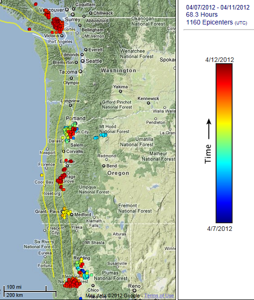
So here is the tremor map from the 7th -11th of this month; before the double Mag 8's across the globe:
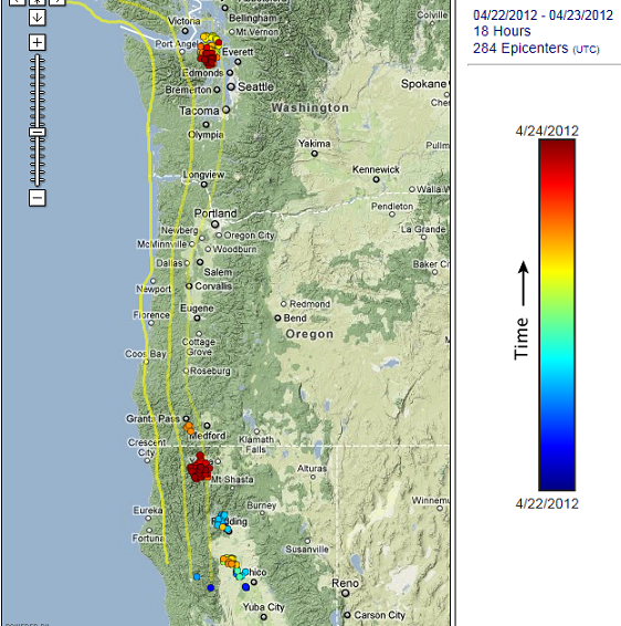
And here is the map from the past 2 days:
Source for above maps
Now, I see that the activity is not up to the level of the earlier "swarm", but maybe it is building?
If I'm learning to interpret the spectrograms correctly, it looks as if the tremor is continuing as I type. Maybe even expanding into southern Oregon. I base this on my purely self-taught correlation of these faint vertical lines, between 2 and 7 Hz, and tremor noted on the map the next day---so scientific. (Watch, it will turn out to be electrical transmission difficulties, and I will be back at square one again.)
While on my internet rounds of earthquake and volcano data, I came across this small sulfur dioxide concentration just near Medicine Lake in northern California. And another well east of Mt. Lassen. NASA SO2 image for 23April -- Pacific NW
Is it posssible for tremor to release gases? Um, is possible for the tremor to "excite" nearby volcanoes into releasing gases?
In the past year of sporadically checking the above site, I've never seen such a concentration. I've checked the US Forest Service site in Modoc, no prescribed burns are going on. And Medicine Lake has only had 6 tiny earthquakes in the past month. I just thought it was curious.
Is there access to Japan's tremor monitoring data, to see if it also showed fault wide activity before the big quakes on April 11th? Maybe the whole of the earth was agitated, and that plate bore the brunt of it.
Lastly, good luck on your presentation tomorrow. Any chance it will be filmed?
Hi John, mind if I pick your brain for a bit?
So here is the tremor map from the 7th -11th of this month; before the double Mag 8's across the globe:
And here is the map from the past 2 days:
Source for above maps
Now, I see that the activity is not up to the level of the earlier "swarm", but maybe it is building?
If I'm learning to interpret the spectrograms correctly, it looks as if the tremor is continuing as I type. Maybe even expanding into southern Oregon. I base this on my purely self-taught correlation of these faint vertical lines, between 2 and 7 Hz, and tremor noted on the map the next day---so scientific. (Watch, it will turn out to be electrical transmission difficulties, and I will be back at square one again.)
While on my internet rounds of earthquake and volcano data, I came across this small sulfur dioxide concentration just near Medicine Lake in northern California. And another well east of Mt. Lassen. NASA SO2 image for 23April -- Pacific NW
Is it posssible for tremor to release gases? Um, is possible for the tremor to "excite" nearby volcanoes into releasing gases?
In the past year of sporadically checking the above site, I've never seen such a concentration. I've checked the US Forest Service site in Modoc, no prescribed burns are going on. And Medicine Lake has only had 6 tiny earthquakes in the past month. I just thought it was curious.
Is there access to Japan's tremor monitoring data, to see if it also showed fault wide activity before the big quakes on April 11th? Maybe the whole of the earth was agitated, and that plate bore the brunt of it.
Lastly, good luck on your presentation tomorrow. Any chance it will be filmed?
edit on 4/24/2012 by Olivine because: (no reason given)
edit on 4/24/2012 by Olivine because: adding more
questions
edit on 4/24/2012 by Olivine because: my spell checking sucks
reply to post by Olivine
Lots of sensible questions.
First, our talks tomorrow will apparently be taped and available, from the flyer
www.crew.org...:
"This presentation will be recorded. Please visit www.crew.org to view a recording of this presentation after April 30, 2012."
Second, I have no idea about gas emissions. Maybe I should, but I feel lucky to remember my own name today.
Third, before speculating about forces acting across the Pacific Plate, remember that any motion has to be smaller than that detectable by GPS, less than a cm, so it is hard to imagine that stress can span between Japan and Cascadia.
Now I'd better piece together a talk for tomorrow.
John
new topics
-
Who guards the guards
US Political Madness: 51 minutes ago -
Has Tesla manipulated data logs to cover up auto pilot crash?
Automotive Discussion: 2 hours ago -
whistleblower Captain Bill Uhouse on the Kingman UFO recovery
Aliens and UFOs: 7 hours ago -
1980s Arcade
General Chit Chat: 9 hours ago -
Deadpool and Wolverine
Movies: 10 hours ago -
Teenager makes chess history becoming the youngest challenger for the world championship crown
Other Current Events: 11 hours ago
top topics
-
Lawsuit Seeks to ‘Ban the Jab’ in Florida
Diseases and Pandemics: 15 hours ago, 20 flags -
Starburst galaxy M82 - Webb Vs Hubble
Space Exploration: 17 hours ago, 13 flags -
CIA botched its handling of sexual assault allegations, House intel report says
Breaking Alternative News: 12 hours ago, 8 flags -
15 Unhealthiest Sodas On The Market
Health & Wellness: 17 hours ago, 6 flags -
whistleblower Captain Bill Uhouse on the Kingman UFO recovery
Aliens and UFOs: 7 hours ago, 6 flags -
1980s Arcade
General Chit Chat: 9 hours ago, 4 flags -
Deadpool and Wolverine
Movies: 10 hours ago, 3 flags -
Teenager makes chess history becoming the youngest challenger for the world championship crown
Other Current Events: 11 hours ago, 3 flags -
Who guards the guards
US Political Madness: 51 minutes ago, 1 flags -
Has Tesla manipulated data logs to cover up auto pilot crash?
Automotive Discussion: 2 hours ago, 0 flags
active topics
-
-@TH3WH17ERABB17- -Q- ---TIME TO SHOW THE WORLD--- -Part- --44--
Dissecting Disinformation • 609 • : Justoneman -
whistleblower Captain Bill Uhouse on the Kingman UFO recovery
Aliens and UFOs • 7 • : pianopraze -
CIA botched its handling of sexual assault allegations, House intel report says
Breaking Alternative News • 6 • : watchitburn -
They Killed Dr. Who for Good
Rant • 63 • : grey580 -
Scientists Say Even Insects May Be Sentient
Science & Technology • 52 • : Scratchpost -
House Overwhelmingly Passes Funding for Ukraine, Israel and Taiwan
US Political Madness • 58 • : IndieA -
A Better Choice I Think
2024 Elections • 30 • : SchrodingersRat -
Michael Avenatti Says He Will Testify FOR Trump
US Political Madness • 60 • : Justoneman -
The Superstition of Full Moons Filling Hospitals Turns Out To Be True!
Medical Issues & Conspiracies • 17 • : Scratchpost -
1980s Arcade
General Chit Chat • 9 • : theatreboy
9