It looks like you're using an Ad Blocker.
Please white-list or disable AboveTopSecret.com in your ad-blocking tool.
Thank you.
Some features of ATS will be disabled while you continue to use an ad-blocker.

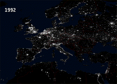
Earth From Space: Night Lights Europe increasing between 1992 And 2010...
page: 18
share:
This very impressive comparison was created using the DMSP satellites images; we can clearly see the increasing intensity of lights from cities and
along the roads in Europe:
Hi-resolution GIF can be seen here
By indicating population and economic growth, bright spots on these images also represent areas of high energy consumption, emissions and pollution – factors that greatly contribute to climate change.
Read the whole article here
This animation is made up of two images of Europe at night showing lights from sources in cities and along roads in 1992 and 2010. Bright areas highly correlate with high population density – such as the densely populated cities like London, Paris and Rome. Coastal areas are also more populated than inland regions, making the outline of Europe clearly visible in these night images.
The images were acquired by the United States’ DMSP satellites. The DMSP satellites are run by the National Oceanic and Atmospheric Administration, monitoring the meteorological, oceanographic and solar–terrestrial physics environments for the US Department of Defense. Data from DMSP’s Operational Linescan System can be used to see city lights.
Hi-resolution GIF can be seen here
By indicating population and economic growth, bright spots on these images also represent areas of high energy consumption, emissions and pollution – factors that greatly contribute to climate change.
Read the whole article here
I don't mind saying that your threads are coming to be some I look forward to finding when I log in each day. I always enjoy the new perspective and
flat out wonder you manage to bring with your material.
reply to post by elevenaugust
The UK does not get much brigther
But the rest of Europe looks like its been dragged out of the dark ages
Good post
SnF
The UK does not get much brigther
But the rest of Europe looks like its been dragged out of the dark ages
Good post
SnF
reply to post by elevenaugust
Whoa.
That's kind of pretty, in a scary kind of way.
Why is the Nile so lit up??
Whoa.
That's kind of pretty, in a scary kind of way.
Why is the Nile so lit up??
reply to post by elevenaugust
Cool pics... but to think that we humans are capable of changing the climate of an entire planet, especially in such a short amount of time, is not only arrogant, but it is absurd.
Cool pics... but to think that we humans are capable of changing the climate of an entire planet, especially in such a short amount of time, is not only arrogant, but it is absurd.
That's actually quite scary.
Imagine what it'll be like in 20 years. Will there be any countryside left?
Imagine what it'll be like in 20 years. Will there be any countryside left?
reply to post by OptimusSubprime
Is it really, i don't think so.
look at this document, and start thinking.
Can be a little heavy.
www.nap.edu...
Thread i made on that topic which got nowhere, propably because people don't care, not their problem..
www.abovetopsecret.com...
Is it really, i don't think so.
look at this document, and start thinking.
Can be a little heavy.
www.nap.edu...
Thread i made on that topic which got nowhere, propably because people don't care, not their problem..
www.abovetopsecret.com...
edit on 3-4-2012 by Mianeye because: (no reason given)
edit on 3-4-2012 by
Mianeye because: (no reason given)
Originally posted by Mianeye
reply to post by OptimusSubprime
Is it really, i don't think so.
look at this dokument, and start thinking.
Can be a little heavy.
www.nap.edu...
Yeah, so can this one:
The Hockey Stick Illusion: Climategate and the Corruption of Science
I know the Global Warming Kool Aid tastes good, but don't swallow it until you've read this.
Thank you everyone!
I just created another one using China as a reference point with the ndgc.nooa datas. The progression year by year can be seen on this site as well.
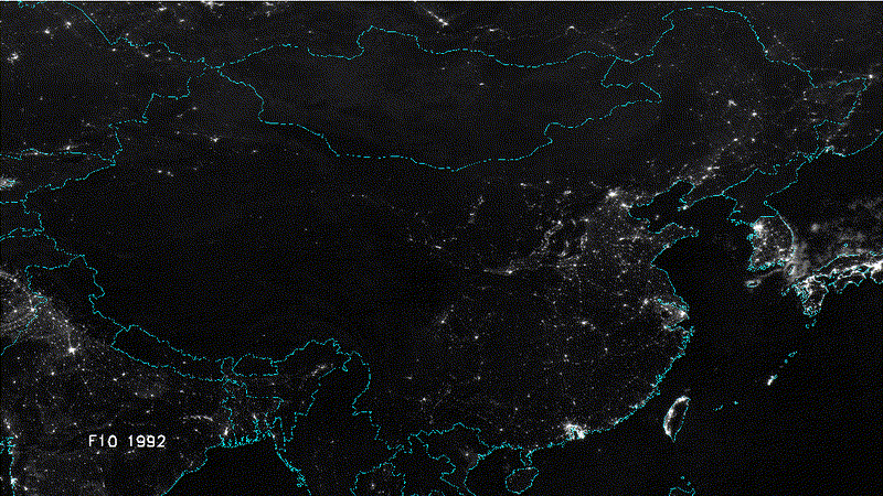
I'm currently working on a USA map as well... Stay tuned!!
I just created another one using China as a reference point with the ndgc.nooa datas. The progression year by year can be seen on this site as well.
I'm currently working on a USA map as well... Stay tuned!!
edit on 3-4-2012 by elevenaugust because: (no reason given)
reply to post by schuyler
Yeah, seen that a thousend times now, and i really don't care if they have faked the story about global warming, the last 10 years the weather around me has changed to something crazy, i follow that story, it tells it much better than any scientist.
And i will bet you didn't read the document...
Yeah, seen that a thousend times now, and i really don't care if they have faked the story about global warming, the last 10 years the weather around me has changed to something crazy, i follow that story, it tells it much better than any scientist.
And i will bet you didn't read the document...
edit on 3-4-2012 by Mianeye because: (no reason given)
edit on 3-4-2012 by Mianeye because: (no reason given)
extra DIV reply to post by Mianeye
A document created by someone or a group of people with an established bias beforehand is of no interest to me. The Earth is more than capable of handling us humans... she has been through far worse.
A document created by someone or a group of people with an established bias beforehand is of no interest to me. The Earth is more than capable of handling us humans... she has been through far worse.
Originally posted by Mianeye
reply to post by OptimusSubprime
I won the bet.
But thank you for your opinion.
Congratulations... and thank you for thanking me. To me this argument has become old and redundant, and if you've read one document from the church of climatology you've read them all.
reply to post by elevenaugust
Look at North Korea.
They're so energy efficient!
hahahahahahahahaha
As to the Global warming issue. The numbers are milked and the science isn't there. I don't mean it's not happening, but what I do mean is that it is something beyond our wee control.
It seems to be a cycle of sorts. Maybe we are still coming out of the Ice age? Maybe this part of space has ambient radiation, like an energy cloud we may be going through? Maybe the 5th sun is on the horizon?
who knows? The whole humans are evil thing is so old, and it's meant to keep you down, where you belong. Go back to sleep.
New thread that supports me
Look at North Korea.
They're so energy efficient!
hahahahahahahahaha
As to the Global warming issue. The numbers are milked and the science isn't there. I don't mean it's not happening, but what I do mean is that it is something beyond our wee control.
It seems to be a cycle of sorts. Maybe we are still coming out of the Ice age? Maybe this part of space has ambient radiation, like an energy cloud we may be going through? Maybe the 5th sun is on the horizon?
who knows? The whole humans are evil thing is so old, and it's meant to keep you down, where you belong. Go back to sleep.
edit on 4/3/2012 by
Dustytoad because: (no reason given)
edit on 4/3/2012 by Dustytoad because: (no reason given)
edit on 4/3/2012 by
Dustytoad because: (no reason given)
edit on 4/3/2012 by Dustytoad because: (no reason given)
New thread that supports me
edit on 4/3/2012 by Dustytoad because: (no reason
given)
new topics
-
Any one suspicious of fever promotions events, major investor Goldman Sachs card only.
The Gray Area: 1 hours ago -
God's Righteousness is Greater than Our Wrath
Religion, Faith, And Theology: 5 hours ago -
Electrical tricks for saving money
Education and Media: 9 hours ago -
VP's Secret Service agent brawls with other agents at Andrews
Mainstream News: 10 hours ago -
Sunak spinning the sickness figures
Other Current Events: 11 hours ago -
Nearly 70% Of Americans Want Talks To End War In Ukraine
Political Issues: 11 hours ago
top topics
-
VP's Secret Service agent brawls with other agents at Andrews
Mainstream News: 10 hours ago, 9 flags -
Cats Used as Live Bait to Train Ferocious Pitbulls in Illegal NYC Dogfighting
Social Issues and Civil Unrest: 14 hours ago, 8 flags -
Electrical tricks for saving money
Education and Media: 9 hours ago, 4 flags -
Nearly 70% Of Americans Want Talks To End War In Ukraine
Political Issues: 11 hours ago, 3 flags -
Sunak spinning the sickness figures
Other Current Events: 11 hours ago, 3 flags -
Late Night with the Devil - a really good unusual modern horror film.
Movies: 13 hours ago, 2 flags -
Any one suspicious of fever promotions events, major investor Goldman Sachs card only.
The Gray Area: 1 hours ago, 2 flags -
The Good News According to Jesus - Episode 1
Religion, Faith, And Theology: 16 hours ago, 1 flags -
God's Righteousness is Greater than Our Wrath
Religion, Faith, And Theology: 5 hours ago, 0 flags
active topics
-
SETI chief says US has no evidence for alien technology. 'And we never have'
Aliens and UFOs • 60 • : Scratchpost -
Election Year 2024 - Interesting Election-Related Tidbits as They Happen.
2024 Elections • 73 • : Threadbarer -
Sunak spinning the sickness figures
Other Current Events • 8 • : McUrnsalso -
God's Righteousness is Greater than Our Wrath
Religion, Faith, And Theology • 10 • : randomuser2034 -
-@TH3WH17ERABB17- -Q- ---TIME TO SHOW THE WORLD--- -Part- --44--
Dissecting Disinformation • 661 • : Justoneman -
HORRIBLE !! Russian Soldier Drinking Own Urine To Survive In Battle
World War Three • 36 • : TheMisguidedAngel -
British TV Presenter Refuses To Use Guest's Preferred Pronouns
Education and Media • 146 • : Consvoli -
Nearly 70% Of Americans Want Talks To End War In Ukraine
Political Issues • 19 • : Consvoli -
Terrifying Encounters With The Black Eyed Kids
Paranormal Studies • 76 • : Consvoli -
Samuel Aun Woer
Religion, Faith, And Theology • 27 • : helebi20
8