It looks like you're using an Ad Blocker.
Please white-list or disable AboveTopSecret.com in your ad-blocking tool.
Thank you.
Some features of ATS will be disabled while you continue to use an ad-blocker.

UFOs? Motherships? naaah. Hole Punch Clouds and their possible source
page: 13
share:
In light of the much chatted about controversy concerning the recent Moscow Mothership event and some other similar events, it seems that maybe Mother
Nature for some reason or other is teaching Meteorology something new and perhaps pointing to something much older than they suspected.
There have been many speculative theories bandied about concerning this cloud phenomenon. We have seen and read everything from the much speculated reasoning of being caused by a craft of some sort by possibly being "punched through" by the craft itself all the way over to the less speculative end's hypothesized guess of sudden updrafts or to the much more readily accepted response of ice crystals combined with the Jet Stream. In my opinion, and I stress my opinion, it is not UFOs creating this phenomenon unless of course it is a UFO in the strictest sense of the definition and not the Pleiadians or the Zetas.
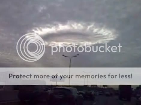
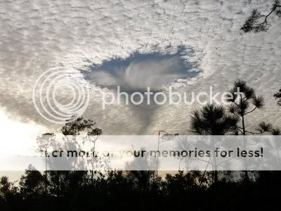
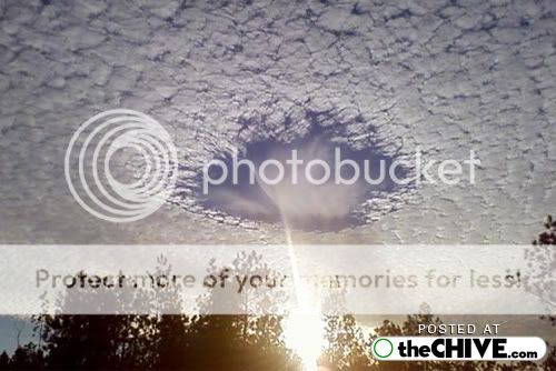
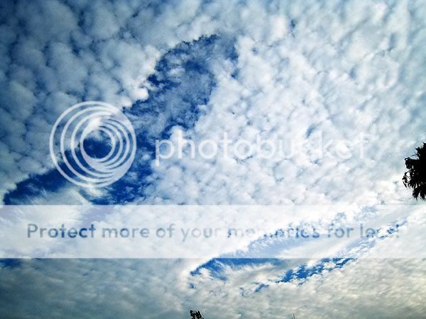
Below are examples of Hole Punch Clouds.


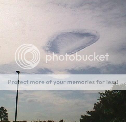
And of course the now infamous one over Moscow as of recent.
Here is another possible explanation:
Source and rest of story
A weather columnist in Florida has this to say about the peculiar cloud formations:
Source
It appears that there isn't anybody nailing down an absolute cause at a meteorological level as yet although the latest explanations certainly seem the most viable.
There are of course, two more most definite sources for the Hole Punch Cloud formations. No theorizing is necessary. It is a quick lesson in absolute quintessential obviousness. Although I should think that the safest place to watch them form is on board the ISS such as the first example below.
Here is also this nice slide show of volcanic related Hole Punch Cloud formation from the ISS.
However, there is possibly no safe place to witness the last type of Hole Punch Cloud formation and I pray that none of us ever see it in this capacity or in our collective lifetimes.
I would much enjoy other Meteorologist types to join in on this thread and expand and expound on so that perhaps some of the confusion can be put to rest. OZ the Weatherman?! Are you here? Jump in, Buddy!
Please enjoy this thread. It was fun creating it and I felt it was necessary so that this factor of UFOlogy can perhaps be for once deductively eliminated.
Cheers,
Erik
[edit on 22/OctpmWed, 14 Oct 2009 22:36:57 -0500/08 by redwoodjedi]
[edit on 22/OctpmWed, 14 Oct 2009 22:37:49 -0500/08 by redwoodjedi]
There have been many speculative theories bandied about concerning this cloud phenomenon. We have seen and read everything from the much speculated reasoning of being caused by a craft of some sort by possibly being "punched through" by the craft itself all the way over to the less speculative end's hypothesized guess of sudden updrafts or to the much more readily accepted response of ice crystals combined with the Jet Stream. In my opinion, and I stress my opinion, it is not UFOs creating this phenomenon unless of course it is a UFO in the strictest sense of the definition and not the Pleiadians or the Zetas.
Below are examples of Hole Punch Clouds.
And of course the now infamous one over Moscow as of recent.
Here is another possible explanation:
The unusual clouds formed from an aircraft dissipation hole or trail is given the name of Hole Punch. This type of cloud is in round or oval shape. This appears in thin layers. This type of cloud is common in areas where jet flight paths intersect altocumulus or cirrocumulus layers. On 11th December 2003 the usually cloud were formed over the Mobile, Alabama area. The clouds were given the name of Hole Punch. These clouds were also seen in south Florida, the Carolinas and even Australia and Canada. It means that it is not uncommon but happens on an infrequent basis.
Source and rest of story
A weather columnist in Florida has this to say about the peculiar cloud formations:
Ice crystals, jet stream winds combine for rare display By David Larimer FLORIDA TODAY weather columnist A unusual cloud formation appeared in skies over the Space Coast on Thursday caused by ice crystals and enhanced by the jet stream. There is no scientific term for the cloud display you see above. The National Weather Service calls the formation "hole-punch" clouds because of the oval-shaped opening. The image was captured by meteorologists Matt Bragaw and Peter Blottman at the weather service office in Melbourne on Thursday morning. The display is rare but has occurred in Melbourne skies in years past. In 1993, the weather service's Dennis Decker photographed a similar display. His dramatic photo was published in a national weather magazine. Randy Lascody, a senior meteorologist at the weather service office, explained the conditions that led to the striking formation: "The atmosphere on Thursday was very dry from about 5000 to 28,000 feet. There was a rather extensive deck of cirrocumulus (mixture of 'super cooled' water droplets and ice crystals) invading the sky associated with strong westerly jet stream winds. "However, the 'hole-punch' features were aligned north/south. This suggests that there was some sort of 'wave' in the atmosphere that was causing rising/sinking air couplets. "This would cause ice crystals in the descending portion of the wave to fall into the super cooled (liquid) cloud layer. When this occurs, the ice crystals grow (at the expense of the liquid droplets). Therefore, a hole opened in the deck of cirrocumulus. "This process is similar to the principle used in cloud seeding to make cloud particles larger and produce precipitation. In this case, the precipitation aloft (meteorological term is 'virga') descended into the dry air below 28,000 feet and evaporated (actually, the proper term for this process is 'sublimated'). "The virga is evident in a few of the pictures descending from the center of the hole in the clouds. This resulted in a cone-shaped cloud high in the atmosphere that I'm sure a few people thought was a funnel cloud."
Source
It appears that there isn't anybody nailing down an absolute cause at a meteorological level as yet although the latest explanations certainly seem the most viable.
There are of course, two more most definite sources for the Hole Punch Cloud formations. No theorizing is necessary. It is a quick lesson in absolute quintessential obviousness. Although I should think that the safest place to watch them form is on board the ISS such as the first example below.
Here is also this nice slide show of volcanic related Hole Punch Cloud formation from the ISS.
However, there is possibly no safe place to witness the last type of Hole Punch Cloud formation and I pray that none of us ever see it in this capacity or in our collective lifetimes.
I would much enjoy other Meteorologist types to join in on this thread and expand and expound on so that perhaps some of the confusion can be put to rest. OZ the Weatherman?! Are you here? Jump in, Buddy!
Please enjoy this thread. It was fun creating it and I felt it was necessary so that this factor of UFOlogy can perhaps be for once deductively eliminated.
Cheers,
Erik
[edit on 22/OctpmWed, 14 Oct 2009 22:36:57 -0500/08 by redwoodjedi]
[edit on 22/OctpmWed, 14 Oct 2009 22:37:49 -0500/08 by redwoodjedi]
The first three pictures you showed are a perfect example of virga pushing through a layer of altocumlus, you can actually see the cirrus in the
middle of the hole
There was also a good picture of a jet creating a line through an altocumulus layer, I will try to find it.
Also, the description given by the meteorologist is pretty much dead on. I dont think I could expand on that at all.
Maybe we should call for observations of this phenomen to be posted here as a sticky. I can post the weather balloon data and we could compare the observations to this information. Just an idea
reply to post by OzWeatherman
Cool Beans, OZ!! I thought you might enjoy this thread. It was long overdue in my humble opinion, what with all of the Moscow mess going on.
Cheers and Thanks in advance!
Erik
Cool Beans, OZ!! I thought you might enjoy this thread. It was long overdue in my humble opinion, what with all of the Moscow mess going on.
Cheers and Thanks in advance!
Erik
reply to post by redwoodjedi
Yep no worries
I think this should be moved to the fragile earth froum though....esepcially if we are able to make it into a sticky
Yep no worries
I think this should be moved to the fragile earth froum though....esepcially if we are able to make it into a sticky
Originally posted by OzWeatherman
reply to post by redwoodjedi
Yep no worries
I think this should be moved to the fragile earth froum though....esepcially if we are able to make it into a sticky
I agree except I think the Saucer Folks should take a boo at it first before it drifts over into the Never, Never.
Cheers,
Erik
Ice crystals is the lupus of anomalies.
[edit on 14-10-2009 by Unregistered]
[edit on 14-10-2009 by Unregistered]
circles and spheres are very common shapes that occur in nature. Uncommon cloud anomalies shouldn't be dubbed supernatural or otherwise without full
understanding of what's going on . . .
as for me, i wouldn't presume to know what causes those cloud formations.
as for me, i wouldn't presume to know what causes those cloud formations.
I think before we go jumping on to the Supernatural or Paranormal bandwagon for this phenomenon, we should first look for something quite prosaic and
Earthly in the form of answers. Only when we shake our collective heads in abject awe after having thrown every resource of known knowledge at it can
we then hypothesize on something "beyond" knowing, scope and understanding.
Thanks for the responses thus far!
Cheers,
Erik
Thanks for the responses thus far!
Cheers,
Erik
Originally posted by OzWeatherman
The first three pictures you showed are a perfect example of virga pushing through a layer of altocumlus, you can actually see the cirrus in the middle of the hole
There was also a good picture of a jet creating a line through an altocumulus layer, I will try to find it.
Also, the description given by the meteorologist is pretty much dead on. I dont think I could expand on that at all.
Maybe we should call for observations of this phenomen to be posted here as a sticky. I can post the weather balloon data and we could compare the observations to this information. Just an idea
Hey there, OZ,
Are you going to post the photo of the jet/altocumulus event? I would be very much interested in seeing that. Also the weather balloon data would be most beneficial to have on board as well.
Thanks for your expertise. It is much appreciated.
Cheers,
Erik
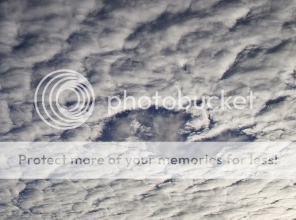
Here are some more absolutely gorgeous examples of Hole Punch Cloud formations to reference, admire and marvel over. I find them fantastically
intriguing in no small way. Beauty. Wondrous beauty.

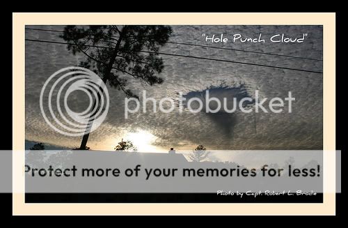


Some of these just still my breath. The orangey sunset one is a killer!
Cheers,
Erik
Some of these just still my breath. The orangey sunset one is a killer!
Cheers,
Erik
reply to post by redwoodjedi
wow. what incredible pics. I think I am gonna save them to a slide show and make it my screen saver. Meteorologically speaking it seems that a higher layer of colder air dropped down through a altostratus layer and created virga, not a cirrostratus layer dropping virga through a altostratus layer. I think each pic needs its own evaluation. The sunset is the one I was referencing (among a few others) Do not discount how far up a micro-climate can cause srange cloud formations, i.e. the punch hole pic with the foreground being a mountainous area and a large lake. Also, for the ufo's are the cause type people. First, aerodynamics don't work that way, clouds can be moved, not removed. Although? Secondly, if there are ufo's built by us or "others" and want to not be seen. A daylight decent through through a cloud layer, thereby rendering and "cloaking device" void. Unless the military is testing a new system over one of the densist city in Russia. If they had went 100 miles east nothing but wildlife would have seen it
edit to add: how /why in the first pic of the OP that there are two holes of seemingly identical proportion so close together with no virga decending from it? or
[edit on 15-10-2009 by jacksmoke]
IT IS mothership (Supreme Command Starship) , You WILL not Spread Lies (Falsitudes) anymo-re
Originally posted by jacksmoke
reply to post by redwoodjedi
edit to add: how /why in the first pic of the OP that there are two holes of seemingly identical proportion so close together with no virga decending from it? or
[edit on 15-10-2009 by jacksmoke]
What we can see in these great photographs does not really match the theory, so the theory needs to be explained for each example. Cause and effect need to be worked out for each one, or at least as much as can be worked out from the visual evidence.
How do you get so many different shapes when it is the same process? I have only read of the process for the creation of circles and yet it is assumed that this process also creates all hole punch clouds? It especially needs to be investigated and explained for the long clearings.
similar cloud to the moscow hole punch cloud
(can someone let me know how to post images on the forum, thanks!)
But for the moscow hole punch cloud the cloud seems much thicker and it also has a central circle of cloud. The image above is the only image i could find that is close to the moscow hole punch cloud.
One thing is that the clouds surrounding the whole in a lot of them seem to be the same type.
The shape of the virga also should be examined as it seems to be precise. In some of them there is a central line with the virga coming from that, looks like a butterfly. In others the virga is pulled or pushed to one side, seeming to show a strong wind or is it something else pulling or pushing it?
[edit on 16-10-2009 by lightning rodney]
reply to post by lightning rodney
I would agree with the theory that aircraft caused some, especially the 'butterfly' shaped virga. If a aircraft is flying in or slightly above a alto stratus layer, the particulate in the exhaust may attach itself to the suspended ice crystals causing them to be heavier than the surrounding ice crystals, also what can give shape to these could be the wake turbulence created as the plane flys. Wake turbulence sinks as it disapates. Wake turb. are like little side-ways tornados that is a by-product of creating lift. So, with the addition of exhuast, rotational wake turb. vorticies, creates the virga then prevailing winds blows and finish giving it its' shape. O.K. one down. Who has the answer for the Moscow cloud?
I would agree with the theory that aircraft caused some, especially the 'butterfly' shaped virga. If a aircraft is flying in or slightly above a alto stratus layer, the particulate in the exhaust may attach itself to the suspended ice crystals causing them to be heavier than the surrounding ice crystals, also what can give shape to these could be the wake turbulence created as the plane flys. Wake turbulence sinks as it disapates. Wake turb. are like little side-ways tornados that is a by-product of creating lift. So, with the addition of exhuast, rotational wake turb. vorticies, creates the virga then prevailing winds blows and finish giving it its' shape. O.K. one down. Who has the answer for the Moscow cloud?
reply to post by fishspeaker
Back your statement up with evidence. Your statement is pretty weak by itself. Making "IT IS" all caps didn't do anything to convince me either, really.
I'm sticking with the mundane, myself...until you come back with the evidence, of course.
Good thread Jedi!. S+F
Cuhail
Back your statement up with evidence. Your statement is pretty weak by itself. Making "IT IS" all caps didn't do anything to convince me either, really.
I'm sticking with the mundane, myself...until you come back with the evidence, of course.
Good thread Jedi!. S+F
Cuhail
Originally posted by lightning rodney
Originally posted by jacksmoke
reply to post by redwoodjedi
edit to add: how /why in the first pic of the OP that there are two holes of seemingly identical proportion so close together with no virga decending from it? or
[edit on 15-10-2009 by jacksmoke]
What we can see in these great photographs does not really match the theory, so the theory needs to be explained for each example. Cause and effect need to be worked out for each one, or at least as much as can be worked out from the visual evidence.
similar cloud to the moscow hole punch cloud
(can someone let me know how to post images on the forum, thanks!)
[edit on 16-10-2009 by lightning rodney]
Hey, LR!
Yeah there might be other contingencies to forming these things. I myself not being a qualified Meteorologist to begin to expound on these formations' causations and implications, can't even begin to explain this phenomenon beyond a rudimentary understanding of heated and cooled layers of air and ice crystals.
Now, let's have a lesson that I can give. Photo uploading. My favorite way to do it is, I have a FREE Photo Bucket account.
Go here
After you have your photobucket account set up in a jif! you can now begin saving images to your computer from all over the place. Fun!
Now you can upload your images to your PB account. You can even adjust the size of the file during the upload process. Once you have the images up in your album, roll over the image you want to post with the cursor. You will notice a drop down menu for four different options of posting. For this site you want the IMG code which is the one on the bottom of the menu. Copy that sucker and paste it on your post!
Cheers,
Erik
Here is a short article I found on the Moscow Hole Punch Cloud. Enjoy!
Source
Meteorology still says "Not a UFO". However, their still not saying what it is exactly...
Cheers,
Erik
[edit on 22/OctpmFri, 16 Oct 2009 16:54:02 -0500/08 by redwoodjedi]
Hole Punch Cloud – Not UFO – Spotted over Moscow
Posted by Jay Michaels on 10/12/09 •
A rare cloud formation was spotted over Moscow this week, inciting widespread discussion of UFO sightings throughout the city – concerns which spread across the globe instantly via the internet. The British tabloid The Sun reported as a “Mystery UFO Halo” over Moscow although it was likely simply an interesting phenomenon created by planes flying through layers of thin high-altitude clouds. A "hole punch cloud" as seen over Moscow last week. Such clouds are rare and awe-inspiring as their cause is still somewhat mysterious. A "hole punch cloud" as seen over Moscow last week. Such clouds are rare and awe-inspiring as their cause is still somewhat mysterious. Hole punch clouds are often attention-grabbers, as they are relatively rare. When they do form, they tend to persist and are large enough to be seen for miles around. The foundation of a hole punch cloud is traditionally a mid- or high-altitude cloud type such as cirrus or cirro-stratus. Such clouds generally form above 20,000 feet or so in the atmosphere. The National Weather Service has explained that such clouds are frequently composed of both ice crystals and super-cooled water droplets – water that is below the freezing temperature but still exists in liquid form. When such a delicate balance occurs, only a slight disruption of this delicate balance may lead to a striking result. This hole punch cloud is a particularly vibrant example of both the foundational cloud form and the evaporation of the water droplets in the surrounding environment. Some hold punch clouds are even referred to as "crop circles in the sky." This hole punch cloud is a particularly vibrant example of both the foundational cloud form and the evaporation of the water droplets in the surrounding environment. Some hold punch clouds are even referred to as "crop circles in the sky." A hole punch cloud photographed over Alabama in 2003. Photo Source: Gary Beeler, Warning Coordination Meteorologist, National Weather Service Mobile, Alabama. A hole punch cloud photographed over Alabama in 2003. Photo Source: Gary Beeler, Warning Coordination Meteorologist, National Weather Service Mobile, Alabama. Frequently, the ice crystals may slowly grow and expand at the expense of the liquid droplets. But when the balance is disrupted, the droplets may freeze instantly and thus permit the liquid droplets in the environment to evaporate, resulting in a “hole” in the cloud. Another hole punch cloud, this one photographed over Colorado in 2007. Photo source: Colorado Uerlings:
www.neatorama.com...
Another hole punch cloud, this one photographed over Colorado in 2007. Photo source: Colorado Uerlings:
www.neatorama.com...
It is believed that a cloud may be disrupted in this manner when a a jet flies through the thin cloud layer. Such a disruption may spur the quick freezing of liquid droplets and evaporation of other droplets. This would create the void in the space in which the jet passed through the layer. While the source of hole punch clouds may be somewhat uncertain, they are certain to cause quite a vigorous discussion.
Source
Meteorology still says "Not a UFO". However, their still not saying what it is exactly...
Cheers,
Erik
[edit on 22/OctpmFri, 16 Oct 2009 16:54:02 -0500/08 by redwoodjedi]
When I saw one of these 'holes' for the first time it was clean. A perfect circle, with no trails, swooshes or remnants of other clouds. It looked
like something had heated, rather than cooled, the cloud, much like the effect of dipping a finger covered in washing up liquid in to oil floating on
water.
It got me thinking.
The next day there was an earthquake in the Far East, Bangladesh or some such.
Then the thought suddenly came to me. What if it was an orbiting satellite of some kind that created the wave/pulse/jet/laser that created the hole.
No proof. Just a thought.
It got me thinking.
The next day there was an earthquake in the Far East, Bangladesh or some such.
Then the thought suddenly came to me. What if it was an orbiting satellite of some kind that created the wave/pulse/jet/laser that created the hole.
No proof. Just a thought.
new topics
-
Massachusetts Drag Queen Leads Young Kids in Free Palestine Chant
Social Issues and Civil Unrest: 12 seconds ago -
Weinstein's conviction overturned
Mainstream News: 1 hours ago -
Supreme Court Oral Arguments 4.25.2024 - Are PRESIDENTS IMMUNE From Later Being Prosecuted.
Above Politics: 2 hours ago -
Krystalnacht on today's most elite Universities?
Social Issues and Civil Unrest: 2 hours ago -
Chris Christie Wishes Death Upon Trump and Ramaswamy
Politicians & People: 3 hours ago -
University of Texas Instantly Shuts Down Anti Israel Protests
Education and Media: 5 hours ago -
Any one suspicious of fever promotions events, major investor Goldman Sachs card only.
The Gray Area: 7 hours ago
top topics
-
VP's Secret Service agent brawls with other agents at Andrews
Mainstream News: 16 hours ago, 11 flags -
Krystalnacht on today's most elite Universities?
Social Issues and Civil Unrest: 2 hours ago, 7 flags -
Nearly 70% Of Americans Want Talks To End War In Ukraine
Political Issues: 17 hours ago, 6 flags -
Sunak spinning the sickness figures
Other Current Events: 17 hours ago, 5 flags -
Electrical tricks for saving money
Education and Media: 15 hours ago, 5 flags -
Weinstein's conviction overturned
Mainstream News: 1 hours ago, 5 flags -
Supreme Court Oral Arguments 4.25.2024 - Are PRESIDENTS IMMUNE From Later Being Prosecuted.
Above Politics: 2 hours ago, 5 flags -
University of Texas Instantly Shuts Down Anti Israel Protests
Education and Media: 5 hours ago, 3 flags -
Any one suspicious of fever promotions events, major investor Goldman Sachs card only.
The Gray Area: 7 hours ago, 2 flags -
Chris Christie Wishes Death Upon Trump and Ramaswamy
Politicians & People: 3 hours ago, 1 flags
active topics
-
Massachusetts Drag Queen Leads Young Kids in Free Palestine Chant
Social Issues and Civil Unrest • 0 • : FlyersFan -
University of Texas Instantly Shuts Down Anti Israel Protests
Education and Media • 109 • : Consvoli -
British TV Presenter Refuses To Use Guest's Preferred Pronouns
Education and Media • 160 • : WakeUpBeer -
Candidate TRUMP Now Has Crazy Judge JUAN MERCHAN After Him - The Stormy Daniels Hush-Money Case.
Political Conspiracies • 749 • : Justoneman -
God's Righteousness is Greater than Our Wrath
Religion, Faith, And Theology • 26 • : CristianVictoria -
Weinstein's conviction overturned
Mainstream News • 12 • : CristianVictoria -
Nearly 70% Of Americans Want Talks To End War In Ukraine
Political Issues • 82 • : gortex -
Supreme Court Oral Arguments 4.25.2024 - Are PRESIDENTS IMMUNE From Later Being Prosecuted.
Above Politics • 39 • : xuenchen -
Chris Christie Wishes Death Upon Trump and Ramaswamy
Politicians & People • 13 • : mysterioustranger -
"We're All Hamas" Heard at Columbia University Protests
Social Issues and Civil Unrest • 283 • : FlyersFan
3