It looks like you're using an Ad Blocker.
Please white-list or disable AboveTopSecret.com in your ad-blocking tool.
Thank you.
Some features of ATS will be disabled while you continue to use an ad-blocker.

Lloyde England and His Taxi Cab - The Eye Of The Storm
page: 2share:
Originally posted by Anonymous ATS
The north side flight path in the opening post requires over 82 degrees of bank and o over 7.9 Gs. Simple math equations can be used to see your flight path is impossible based on aircraft limits, and witness testimony.
Really?
Sorry mr anonymous but obviously it's impossible to come to those figures without knowing the most relevant value....SPEED!
Great job fabricating equations and values.
Please look into what was depicted in a recently released animation by the FAA and let me know how far off you were.
Why present flawed flight paths and make fun of a person who experienced 9/11 up close and personal?
Please quote where we "made fun of" Lloyde or concede that you are fabricating this claim just like you did your false calculations.
No wonder you're anonymous!
Originally posted by SlightlyAbovePar
In one fell swoop, you have now implicated any and all courts of law. We have gone from Mr. England having his facts mixed up to Mr. England being "in on it", to Mr. England being a 'deep covert operative given the assignment of a lifetime' to Mr. England being the victim of brainwashing to Mr. England and every single court in the land being a 'sham' and therefore "in on it".
Great comment. Another crystal clear explanation why this whole Troofer movement is a joke. The Grand Conspiracy - "EVERYONE is In On It!!" defense is better suited for mental competency hearings than 9/11 scenarios.
It is far easier to take Mr England and disparage him to the max because he's elderly and can't do anything about a bunch of Internet "Playtime Invetsigators" call him a liar and a government stooge than to engage in real, hardcore analysis.
If everyone is in on it, every courtroom in the world, you might as well pack it in. There's no hope for you. Wait. Tezz lives in Aussie land. Who cares what he thinks, anyhow?
[edit on 3-11-2008 by pinch]
Originally posted by pinch
Wait. Tezz lives in Aussie land. Who cares what he thinks, anyhow?
pinch, if you believe that any 'Justice' system is professional and honest, then I really feel sorry for you, mate. We had a recent case in Australia where an ex-Judge pleaded guilty to perjury over not paying a $77 speeding fine. He will still collect his $180,000+ yearly tax-payer funded pension. There were no rules written that could strip him of that money! Justice? No way. All he had to do was pay his $77 speeding fine, instead of lying about it.
Condy Rice lied when she said they could never imagine planes being used as weapons. What has happened to her? Nothing! Justice? No way.
Cheney held Bush's hand when they went together to testify, unsworn, to collectively get their stories straight before the panel. Don't you find that highly suspicious? Justice? No way. They should have been questioned alone. Even ThroatYogurt agrees with this, he stated so in another thread.
General Larry Arnold informed the Commission that NORAD knew about the alleged Flight 77 at 9.24am, which is contrary to the Commission's findings. Why would the Commission not include his evidence? He was a NORAD General, not some shmuck off the street! Justice? No way.
I won't drag this thread off topic, as it's important that Lloyde's story be shown for what he said. He had no explanation for how he could pull out a light pole without scratching his bonnet. He doggedly stated that he was North of the bridge, when he wasn't.
If US 'Justice' can turn a blind-eye to Condy's lies, Cheney coaching Bush and dismiss the evidence of a NORAD General, then how seriously do you think they will take CIT's evidence regarding Lloyde?
It's got NOTHING to do with your inflation theory - it's reality.
reply to post by pinch
Pinch, cut the drama and stick to the facts. The plane flew NoC. 13 corroborating witnesses is enough to convince a jury. How many witnesses saw the light poles get clipped, saw a pole impale Lloyd's cab, saw the plane enter the Pentagon? Ok, let's interview those few witnesses on the record to recount their stories and verify it for inconsistencies and/or lying. Many impact witnesses were caught lying because they were not in a position to see the impact. Just the fact these people lied should make you suspicious as to why they lied. Who told them to lie?
You also need to weed out those who deduced versus those who actually saw. Everyone of the NoC witnesses SAW and did not deduce. Most impact and pole witnesses DEDUCED.
Pinch, whomever you work for, or maybe your denial prohibits you from realizing the truth, please do not insult those who are taking the time to investigate 9/11.
The evidence is what it is.
I'm sorry that it happens to implicate our own government and many others right down to Lloyde England but that is not my fault.
We can't ignore the evidence because we don't like what it proves.
I notice how nobody is contesting the evidence in this thread.
This alone speaks volumes.
I'm sorry that it happens to implicate our own government and many others right down to Lloyde England but that is not my fault.
We can't ignore the evidence because we don't like what it proves.
I notice how nobody is contesting the evidence in this thread.
This alone speaks volumes.
Originally posted by Craig Ranke CIT
I notice how nobody is contesting the evidence in this thread.
This alone speaks volumes.
What evidence? Could you highlight it for us? Evidence that you obviously feel so strong about you'd rather stay on an internet discussion board hyping it than bring it to the attention of a prosecutor or a grand jury or at the very least hold a press conference?
Perhaps you could get your buds at the OC Weekly to help out with that press conf, Craig.
I ask again...WHAT evidence?
posted by jthomas
Did AA77 actually crash on the other side of The Pentagon?
posted by tezzajw
Who knows what happened to the alleged Flight AA77, jthomas? No one has shown the parts of the aircraft tail number N644AA, so it's probably safe to presume that it's missing.
What did you think of the interview with Lloyde? Do you have any thoughts that actually relate to the topic of this thread?
Yes, tail number N644AA has not yet turned up at any aircraft boneyards; although some of the rusty parts allegedly from Flts 77 and 93 appear to have been scrounged up from aircraft boneyards. More likely tail number N644AA resides in the Atlantic Ocean boneyard which is a bit too deep to search.
Unfortunately jthomas is usually stumped by actual thoughts relating to actual evidence in existence. His modus operandi deals more effectively through strawman arguments and red herrings using imaginary evidence and ordinary BS.
Hello.. I have been on this board for many many years and love to read about new things in the 9/11 Movement. I watched this video about a taxi
driver, Lloyd, and I have to say that I am ashamed sometimes to even admit that i'm a truth seeker for 9/11. In my honest opinion, Lloyd was telling
the truth but CIT was to thick headed to realise what the man was trying to say to them. LLoyd only change his story after CIT did because he felt he
may have been wrong or confused. CIT told Lloyd "EVERYONE" says the plane came from the Left of the Citgo...Last time i checked, 13 people is not
everybody, not even close.
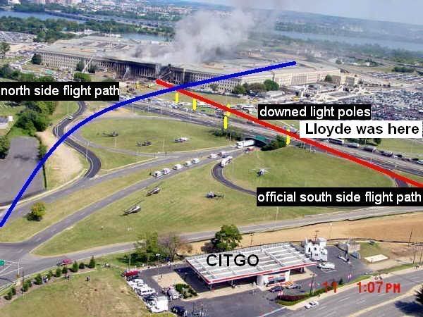
Now, the official flight path has the plane coming over to the right of the Citgo. Lloyd had a lightpole that was pulled by its foundation by an airplane and went straight thru his windshield. What does this tell you? CIT is so stuck on proving this older gentleman wrong about his location, location, location that CIT does not even realise what they are saying to us: If Lloyd WAS by the bridge CIT says he was, and if that lightpole is a real lightpole laying next to his car (lightpole # 1), and there are other lightpoles knocked down next to Lightpole # 1, common sense would tell me that the PLANE CAME FROM WHERE THE OFFICIAL FLIGHT PATH SAID IT DID..LLOYD PROVED IT. So lets solve one case at a time, please: If Lloyd was south of the bridge, then the official flight path is correct? CIT can not be serious when they mention that after 2 planes crashed into the WTC, 1 in Penn state, with all that going on that there were actually black ops driving around with bend light poles in their trucks to lay on the street and to fool us people into believing that this is where the plane flew over. CIT, do not let something as simple as common sense get in the way of your truth seeking.
The #1 Lightpole was pulled from its foundation and bent before hitting the ground, which means the plane was approx 20-30 feet above the roof of Lloyds card as it came over, did Lloyd or did he not feel this plane go over top of him?
Calling Lloyd a liar in his own home is senseless and unprofessional. Lloyd wanted to help, even thou Big Momma said supper was ready, Lloyd wanted to go look at that car with you, he wanted to help you, it had seemed that you brought new life to Lloyd when you arrived at his home.
Just my opinion,thank you
Bud
posted by bud316
Just my opinion,thank you
Bud
Common sense would tell me that the reason Lloyde tried to move his taxi north up Hwy 27 in the 2nd interview, was because he knew the Official Conspiracy Theory (OCT) at the Pentagon was a LIE.
Common sense would tell me that a 90 ton 535 mph 757 aircraft cannot strike a 337 pound light pole with its swept back right wing and knock this light pole past its fuselage and up the road to its left.

Common sense would tell me that a 90 ton 535 mph 757 aircraft cannot strike four other 337 pound 40 foot tall light poles and lay them down gently a few feet from their bases, at the same time ripping several main poles into two pieces.
Common sense would tell me that the 33 foot long light pole in the windshield and sticking out 22 feet in front of the bumper fairy tale was impossible and a LIE.
Common sense would tell me that the 13+ eyewitnesses placing the aircraft above the Naval Annex was the truth and the tale Lloyde was telling a LIE.
Common sense would tell me that a jet aircraft needs jet engines to fly, and that a woman and little boy directly in its path should have been shredded into thin strips and completely burned up. But they were not were they? April Gallup told us NO JET FUEL in her office in the Pentagon Wedge One area.
[edit on 11/7/08 by SPreston]
Common sense would tell me that a 90 ton 535 mph 757 aircraft cannot strike four other 337 pound 40 foot tall light poles and lay them down gently a
few feet from their bases, at the same time ripping several main poles into two pieces.
Sir,
Please relook at those pictures. Your perception of total footage has been distorted. The poles were knocked further then you think. The first pole was hit so hard it seemed to knock the pole end over end till it crashed thru Lloyds windshield. Nothing was sent down "GENTLY" after being hit by the 757 as you have stated above.. How far were the poles supposed to fly anyways? Each one of those poles shows being bent toward the top where the wing or engine had hit it. The plane was so close to the ground i do not personally believe it would have projected the poles that far. Why are the only people interviewed in CITS video say the same thing? I thought it was a truth finding documentary?? They all say (Yep, all 13 of them) "IT CAME FROM THE NORTH SIDE OF THE CITGO, NEXT TO THE ANNEX".. You mean to tell me there is not ONE soul that seen this 757 fly over the highway, knock 5 poles down and explode into the side of the building? The scenerios you are providing us are close to being cartoonish in a sense. In order for Lloyd to be lying, we must be made to believe that he is hiding something. What is he hiding? Is CIT serious when they say Lloyd was actually part of a cover up? There was more then 1 car on that highway with Lloyd at the time, did they all just stop their cars and watch these 5 poles blown from their foundation for no reason (explosives were suggested earlier)? And with all that was going on, you still want us to believe some guy in a van drove by, in front of all these people, as the Pentagon is burning, jumped out of his truck and threw a rock or hammer thru Lloyds windshield to make the actual flight path seem more logical??
THINK!
Remember, I believe in the 9/11 Conspiracy as much as you, and I want to believe, but you can not let your imagination run wild and there is a time when you have to lay this out for yourself and see that what CIT is saying is not 100% accurate. Just like the cop in CITS video that says " I"LL BET MY LIFE ON IT" when asked about the general direction of F77. We'll, i'll bet my life that Lloyd is telling the truth and by no means has anything to hide. I appreciate the hard work being done but I think they are doing nothing but chasing rabbits...
Just my Opinion, Thanks!
Bud316
posted by SPreston
Common sense would tell me that a 90 ton 535 mph 757 aircraft cannot strike four other 337 pound 40 foot tall light poles and lay them down gently a few feet from their bases, at the same time ripping several main poles into two pieces.
posted by bud316
Please relook at those pictures. Your perception of total footage has been distorted. The poles were knocked further then you think. The first pole was hit so hard it seemed to knock the pole end over end till it crashed thru Lloyds windshield. Nothing was sent down "GENTLY" after being hit by the 757 as you have stated above.. How far were the poles supposed to fly anyways? Each one of those poles shows being bent toward the top where the wing or engine had hit it. The plane was so close to the ground i do not personally believe it would have projected the poles that far.
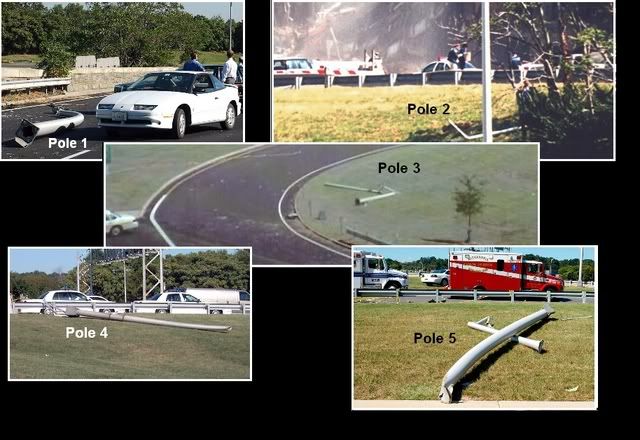
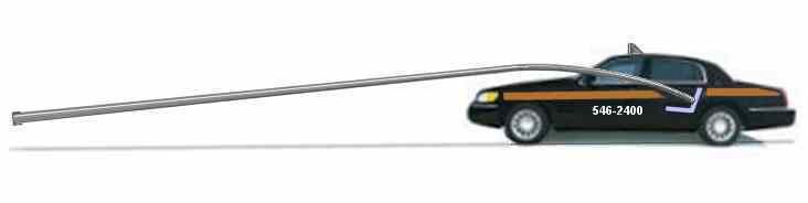
The red dots are locations of the bases.
The white lines are locations of their final resting places
I suggest you need further research before correcting those who have been researching 9-11 for years. Poles #3 #4 and #5 are laying near to their bases, as is #1 pole. There is no apparent damage to the ground nor roadway from violent impact by a 337 pound light pole struck by an alleged 90 ton aircraft flying at 535 mph.
If Lloyde's #1 light pole was knocked end over end before it hit the windshield; then the #1 light pole would continue end over end after it hit the windshield and tear the roof off. It did not.
All the light poles in their final positions
Yet main poles #1 #4 and #5 are severed in two indicating a violent impact which should have hurled them hundreds of feet; not laid them down gently near to their bases. I do not know how to explain it more simply.
[edit on 11/7/08 by SPreston]
Originally posted by bud316
The first pole was hit so hard it seemed to knock the pole end over end till it crashed thru Lloyds windshield. Nothing was sent down "GENTLY" after being hit by the 757 as you have stated above..
Then please explain how the hood, windshield frame, and roof of the car could remain completely undamaged after a 90 ton Boeing traveling 535 mph in the opposite direction of the approximately 40 mph cab while the cab comes to a sliding sideways stop with the pole still in the windshield!
(imagine the big long pole still sticking out of the windshield as Lloyde describes)
And please explain why you feel that this story told by Lloyde is more credible than all 13 north side witnesses?
There is no logic in stating that you don't believe the official story but that you believe this single outrageous and impossible account that supports the official story over all these other accounts that prove it false.
You are having a knee-jerk emotional reaction and are forced to suspend all logic in order to support it.
All in defense of the official story.
Why?
[edit on 7-11-2008 by Craig Ranke CIT]
posted by bud316
Why are the only people interviewed in CITS video say the same thing? I thought it was a truth finding documentary?? They all say (Yep, all 13 of them) "IT CAME FROM THE NORTH SIDE OF THE CITGO, NEXT TO THE ANNEX".. You mean to tell me there is not ONE soul that seen this 757 fly over the highway, knock 5 poles down and explode into the side of the building?
Yep, you figured it out already. A TRUTH Finding Documentary. Now that was quick. Those eyewitnesses all say the same thing because that was what they saw. They had no reason to lie. They just told the truth as they saw it. If an aircraft did fly over the Naval Annex, shouldn't that be what the people beneath it actually saw? Review the videos again. They sure seem honest and sure of what they saw, don't they?
Nope, not one single verifiable eyewitness can be found that saw a lightpole hitting the windshield of the taxi. Not one single verifiable eyewitness can be found that saw a lightpole sticking out of the windshield of the taxi. Not one single verifiable eyewitness can be found seeing two men pulling a lightpole out of the windshield of the taxi.
Not even one eyewitness can be found who saw an aircraft hitting the light poles nor even hitting the Pentagon wall. When defenders of the Official Flight 77 flight path recently went to Arlington County to dig up eyewitnesses to support their story, they found NOBODY. When the Citizen Investigation Team goes down there, they always find SOMEBODY.
Unfortunately the official story witnesses turn out to be somebody without a last name and untraceable, or turn out to be in an office building 10 miles away and a 3rd hand witness, or turn out to be on the bus platform at Reagan National and out of sight of the event and no witness at all, or they turn out to be a MSM reporter who has changed his story because it was convenient, or they turn out to actually be north side Over the Naval Annex eyewitnesses. Isn't that odd? Are you starting to detect a picture here?
So far no verifiable eyewitnesses to the south path have been relocated nor been verified nor been reinterviewed on camera to provide a public eyewitness data base, which everyday Americans can view and decide for themselves if the eyewitness is lying or not.
It seems that would be a good job for you. Go down to Arlington County and find and interview eyewitnesses on camera who can verify Lloyde's pole through the windshield. Maybe some of them even have photos. None of the fanatical pseudoskeptics seem to want to assist the official story line they are such powerful proponents of. Why is that?
You know, The more I learn of this guy = the more he comes off as a BS artist... you know, it would not surprise me one bit, if he picked up the pole
on the road and did that to his cab so he could have a claim... claim equal money... what are the odds of this being true.
posted by BornPatriot
You know, The more I learn of this guy = the more he comes off as a BS artist... you know, it would not surprise me one bit, if he picked up the pole on the road and did that to his cab so he could have a claim... claim equal money... what are the odds of this being true.
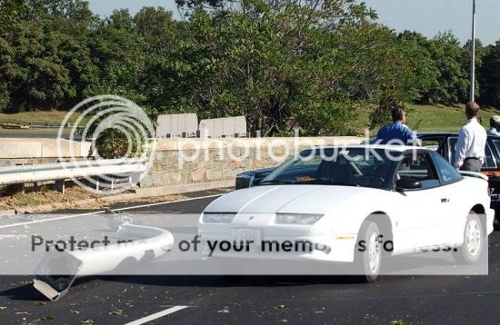
Not likely. The bent pole laying on the road weighed over 200 pounds and was about 33 feet long. It would be almost too heavy and awkward for two men to handle; let alone one old man by himself.
That is probably why it was never stuck through the windshield and left there for photo ops. It would be too heavy for the FBI/Secret Service agents to lift through the windshield, and they would have needed a pole handling machine with a small crane lift and that would have attracted too much attention. So they just dragged it across the road from its hiding place next to the wall and left it laying there near the front of the taxi. Then they took the bag of broken glass and sprinkled it there on the road and placed the other pieces they had brought along. Presto; all ready for photo ops. Simple job of staging which any idiot should have been able to handle without screwing it up.
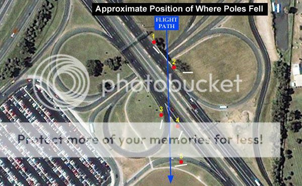
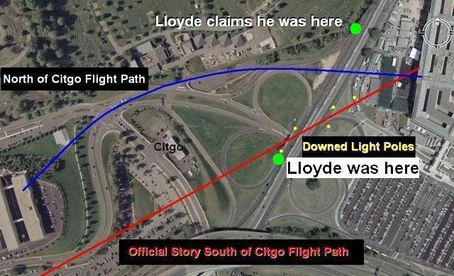
Craig or SPreston, could either of you post an overhead map that shows both where Lloyde's taxi was when it was allegedly hit, and also where he
claims it was when it was allegedly hit?
Not everyone (including me) is familiar with the roads around the Pentagon. So when Lloyde mentions the heliport being near him, it would help to know his alleged location if we could see it on a map?
Seeing the distance between the two locations from overhead will be handy. I kind of have an idea of where he meant, as you were driving in the car with him, Craig, and he was talking to you - but I'd like to know for certain where Lloyde thinks he was, when the taxi was allegedly hit as a pin on a map.
Thanks if you can do it.
Originally posted by tezzajw
Craig or SPreston, could either of you post an overhead map that shows both where Lloyde's taxi was when it was allegedly hit, and also where he claims it was when it was allegedly hit?
Not everyone (including me) is familiar with the roads around the Pentagon. So when Lloyde mentions the heliport being near him, it would help to know his alleged location if we could see it on a map?
Seeing the distance between the two locations from overhead will be handy. I kind of have an idea of where he meant, as you were driving in the car with him, Craig, and he was talking to you - but I'd like to know for certain where Lloyde thinks he was, when the taxi was allegedly hit as a pin on a map.
Thanks if you can do it.
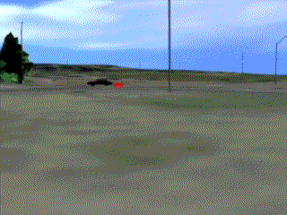
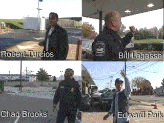
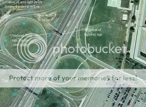
I made up this little plan (2nd image) from a pre-911 aerial photo showing the location of the area light poles and bases. Lloyde wanted to move his taxi north up Hwy 27 to about where the CitGo and ANC eyewitnesses and the newly released September 12 2008 FAA video place the decoy aircraft flight path. The decoy aircraft flew directly over the northern of the two highway signs as indicated by Robert Turcios.
Pentagon Army Heliport
Airport in Arlington County, Virginia, USA.
Latitude: 38.87 : Longitude: -77.06056 : Elevation: 37 ft
www.placenames.com...
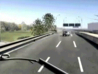
This diagram shows a rough compilation of the flight path according to all the north side eyewitnesses. It is above all the light poles and the overhead sign in its path. The ground level (MSL) altitude is higher than the helipad (37 feet (MSL)) at Hwy 27 and higher yet towards the Citgo and ANC parking lot which the decoy aircraft flew over. If it were a 757, the 124 ft 10 in wingspan would be much too great to slip between the light poles. Therefore the decoy aircraft had to be above them and about at Pentagon rooftop level.
The official flight path aircraft wings are allegedly below the 40 ft tops of the alleged downed light poles at 535 mph, and officially pulled up to level flight inches above the lawn in order to allegedly hit the Pentagon 1st floor and not the building foundation.
Lloyde is much closer to the helipad here, and maybe moreso 'in front of the Pentagon' from his description. That gash in the lawn is pointed almost directly at the 'place of impact' and in alignment with the decoy aircraft flight path from ONA and NOC.
The light poles are a bit more densely packed along the decoy aircraft flight path plus the big overhead sign, yet none of them were laying on the ground. Therefore the decoy aircraft had to be above them, and much too high to impact the 1st floor, and much too far away to hit the #1 pole. Even the #5 light pole would be out of reach of the right wing. This is my understanding of the spot Lloyde indicated; Craig will need to verify and perhaps clarify this a bit.
This aerial view shows about where the downed light poles were staged in comparison to the original location of their bases. Red dots are bases.
]
[edit on 11/9/08 by SPreston]

Actually SPreston he places himself far north from where you indicated.
This gets nailed down in the final segment when we went to the highway at night with all the lightening.
This gets nailed down in the final segment when we went to the highway at night with all the lightening.
new topics
-
A man of the people
Diseases and Pandemics: 22 minutes ago -
Ramblings on DNA, blood, and Spirit.
Philosophy and Metaphysics: 45 minutes ago -
4 plans of US elites to defeat Russia
New World Order: 2 hours ago -
Thousands Of Young Ukrainian Men Trying To Flee The Country To Avoid Conscription And The War
Other Current Events: 5 hours ago -
12 jurors selected in Trump criminal trial
US Political Madness: 8 hours ago -
Iran launches Retalliation Strike 4.18.24
World War Three: 8 hours ago -
Israeli Missile Strikes in Iran, Explosions in Syria + Iraq
World War Three: 9 hours ago
top topics
-
George Knapp AMA on DI
Area 51 and other Facilities: 14 hours ago, 25 flags -
Israeli Missile Strikes in Iran, Explosions in Syria + Iraq
World War Three: 9 hours ago, 16 flags -
Louisiana Lawmakers Seek to Limit Public Access to Government Records
Political Issues: 17 hours ago, 7 flags -
Iran launches Retalliation Strike 4.18.24
World War Three: 8 hours ago, 6 flags -
Not Aliens but a Nazi Occult Inspired and then Science Rendered Design.
Aliens and UFOs: 14 hours ago, 5 flags -
Thousands Of Young Ukrainian Men Trying To Flee The Country To Avoid Conscription And The War
Other Current Events: 5 hours ago, 4 flags -
12 jurors selected in Trump criminal trial
US Political Madness: 8 hours ago, 4 flags -
4 plans of US elites to defeat Russia
New World Order: 2 hours ago, 2 flags -
Ramblings on DNA, blood, and Spirit.
Philosophy and Metaphysics: 45 minutes ago, 1 flags -
A man of the people
Diseases and Pandemics: 22 minutes ago, 0 flags
active topics
-
Mandela Effect - It Happened to Me!
The Gray Area • 111 • : CCoburn -
So I saw about 30 UFOs in formation last night.
Aliens and UFOs • 31 • : Encia22 -
4 plans of US elites to defeat Russia
New World Order • 7 • : Lazy88 -
AARO/Dr Kirkpatrick-Caught Lying in UAP report.
Aliens and UFOs • 25 • : Jukiodone -
Russia Flooding
Fragile Earth • 17 • : Kurokage -
A man of the people
Diseases and Pandemics • 0 • : PrivateAngel -
The Acronym Game .. Pt.3
General Chit Chat • 7729 • : CCoburn -
It has begun... Iran begins attack on Israel, launches tons of drones towards the country
World War Three • 889 • : bally001 -
12 jurors selected in Trump criminal trial
US Political Madness • 23 • : gspatfound -
Ramblings on DNA, blood, and Spirit.
Philosophy and Metaphysics • 0 • : BrotherKinsMan