It looks like you're using an Ad Blocker.
Please white-list or disable AboveTopSecret.com in your ad-blocking tool.
Thank you.
Some features of ATS will be disabled while you continue to use an ad-blocker.

Huge Anomaly Over South Pacific Ocean Right Now
page: 2share:
So now I´m using the NASA Application World Wind to get the accurate cloud formation data.
Just as I am about to go to bed I find Stevie floating near the north pole.
Who is this? Stevie Wonder in a knitted sweater? Are those wings with a round aft?
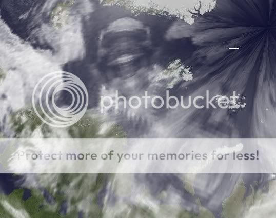
How can artifacts in the cloud data be symmetrical like that?
Stevie is 2300km long and curves nicely along the earth.
Time for bed I guess, I´m starting to see things.
MoonMine
[edit on 12-10-2008 by MoonMine]
Just as I am about to go to bed I find Stevie floating near the north pole.
Who is this? Stevie Wonder in a knitted sweater? Are those wings with a round aft?
How can artifacts in the cloud data be symmetrical like that?
Stevie is 2300km long and curves nicely along the earth.
Time for bed I guess, I´m starting to see things.
MoonMine
[edit on 12-10-2008 by MoonMine]
Originally posted by broli
reply to post by Alxandro
To correct MoonMine the data updates every 3 hours. So sure it could have gotten messed up on a certain run but to be messed for at least 24 hours now or longer is strange.
No, it's not. The positioning of all the satellites used to piece together images are sometimes at certain times of the year in a position to leave little patches dataless. It happened back when I was using Google Earth bata quite a bit. The more advanced the systems get, the less of this will happen. Updating has nothing to do with the piecing together, especially when you realize that the satellites we're using are orbiting the equator at different speeds, sometimes patches are left and it makes the same concept as shining little lights at a globe, at times there's darkness. I'm not saying anyone is wrong in any of their ideas, but 1. If it were a spacecraft, it would have to be between the satellite and the Earth, which means it would be in eyesight distance, 2. If they have the ability to fly at lightspeed or greater without vaporizing then become not only invisible but transparent, they'd know that Google Earth has a weather layer 3. If we see an outline, the government sees inside and has communicated, which means they'd know to prepare for the masses of ignorant people to be flooding the streets going what the hell?
All I'm saying is this is normal and has happened plenty of times before, even when there weren't all these predictions floating around.
reply to post by MoonMine
That's strange, I do 3d and that looks like the verticies on the part of the wireframe has been left there to see, and the verticies are the dots.
Strange, I don't know.
[edit on 12-10-2008 by _Phoenix_]
That's strange, I do 3d and that looks like the verticies on the part of the wireframe has been left there to see, and the verticies are the dots.
Strange, I don't know.
[edit on 12-10-2008 by _Phoenix_]
Originally posted by _Phoenix_
reply to post by MoonMine
That's strange, I do 3d and that looks like the verticies on the part of the wireframe has been left there to see, and the verticies are the dots.
Strange, I don't know.
[edit on 12-10-2008 by _Phoenix_]
Phoenix,
Explain in laymen terms. Thanks
I think more people want to know what this could be?
How do you email Google Earth? I did email that station in Antartica, who usually responds, and i never got an answer from them at all.
Originally posted by Realtruth
Originally posted by _Phoenix_
reply to post by MoonMine
That's strange, I do 3d and that looks like the verticies on the part of the wireframe has been left there to see, and the verticies are the dots.
Strange, I don't know.
[edit on 12-10-2008 by _Phoenix_]
Phoenix,
Explain in laymen terms. Thanks
I think more people want to know what this could be?
Here's a simple wireframe, the dots are verticies. To make a 3d sphere they would have to make something similar, but obviously more round.
Anyway it kind of looks like you can see part of the wireframe, like some sort of mistake or glitch, but it doesn't make sense.
[edit on 12-10-2008 by _Phoenix_]
reply to post by _Phoenix_
If you are referring to the OPs "wireframe" - he drew that on top of the map. Google Earth offers tools to draw lines and connect them (also measure distances from different points), etc...
Otherwise, I am not sure what "wireframe" you are talking about.
Thanks!
If you are referring to the OPs "wireframe" - he drew that on top of the map. Google Earth offers tools to draw lines and connect them (also measure distances from different points), etc...
Otherwise, I am not sure what "wireframe" you are talking about.
Thanks!
reply to post by isilex
I think what Phoenix is referring to is wireframe, like what you would encounter as a virtual 3D image meshing before the outer texture layer is applied on top of it.
Think of creating a wireframe of a skull, out of only, of course, wire. Then appyling rubber on top of that to simulate muscle tissue...and so on...
Satellite images are "sewn" together much in the same way on top of the "wireframe" of the virtual globe. Typically the reasoning for handling thing using this method is, that in the scope of something so dynamic and so large, you want to conserve as much computing power as you can to apply anything that has changed only. This allows for less processing of image data of a 3 dimensional object which translates to faster image response time. Kind of like the same reason web browsers cache images in the Temp Internet Files. THAT and obviously a particular satellite can not possibly be in a particular location that someone wants to view at any one time...so it needs to apply sewn pieces of cached images over a wireframe that is typically indexed.
AB1
[edit on 12-10-2008 by alphabetaone]
Originally posted by MoonMine
Originally posted by jasperaldo
aargh i cant wait anymore! need to know if it's true!
I'm having really bad headaches past days..
Now that you mention it....
I have had them for the last two weeks. Almost always fierce and around the left eye, mostly at night. I think it might be some form of Cluster Headaches which is quite a rare condition (less than 1%)
I have been feeling extremely lethargic the last few days. Maybe it´s all the October 14th anticipation?
We´ll know in 48 hours so we can all go back to our normal lives. (or not)
PS: IF there is something there near Antarctica I am not saying Google is aware of this and covering it up, but rather something is interfering with the satellite data.
MoonMine
I don't buy into this October 14th stuff, but I find it odd that you just described exactly how I've been feeling this past week. Headaches every day, mostly around my left eye, and extremely lethargic. I find that a tad bit odd.
Originally posted by isilex
reply to post by _Phoenix_
If you are referring to the OPs "wireframe" - he drew that on top of the map. Google Earth offers tools to draw lines and connect them (also measure distances from different points), etc...
Otherwise, I am not sure what "wireframe" you are talking about.
Thanks!
Ah thanks now it all makes sense, that came to my mind but I didn't know that.
But I do think the texturing on the wireframe could be the reason why we see these holes, they are probably part of the wireframe not filled in?
Also in the north and south pole there is an odd texture problem that is similar to the shape of this type of wireframe. Look at the top and bottom shape. Now go to the south and north pole on google earth and you can see the same shape on the sea and on Antartica.
I really think it's related to the weather too.
[edit on 12-10-2008 by _Phoenix_]
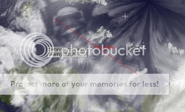
from same source as above I have cropped image for easy posting, haven't added anything - bottom of image shows taken at 00:00 UTC 13th Oct. If you
measure from beginning of line to end, it's roughly 2000 miles give or take.
Source - amrc.ssec.wisc.edu...
Edit: OK that's a bit wierd, most of the web site has gone down, the xcomp gif is still up though. FTP is still working too, but imagery is only from 11th in the archive folder, probably because their backups archive files there and it hasn't caught up.
[edit on 13/10/08 by _EyesOpen_]
Donald Duck
Take a look at the vector graphic on top of some cheap satellites garbage sensory. It doesn't take millions of dollars of funding to build satellites. Satellites are cheap to make and are made of inexpensive materials fabricated in China. A dime a dozen. Paper lanterns if you will. It is obvious that NASA, JPL, and such are a drain on the United States economy. They waste money. Nothing ever arises Discovery except hoaxes and coverups. And of course leaving no mention to fake planned out hardware glitches. Take for instance shares of Google Earth. A complete failure for fraud. NASA needs to be shutdown and dismantled. New companies would emerge much the same way as NASA of course and the great never ending funnel will again take its toll on the dollar.
This is not an image of a black triangle. To all you rock hounds and data merchants that insist putting tilt on the big dipper. The wrecking ball is coming.
HAIL TO THE KING
reply to post by MoonMine
What is more realistic? The presence of an alien spaceship eliminating all activity in the troposphere, or satellites failing to transmit data, or more simply a software bug in Google Earth?
Oh, you're completely wrong here. NASA is operated by the government. It is in no way a private company. With private ventures, you have individuals seeking profit, so there is no room for inefficiency. There would be no blatant government spending, along with the present lack of discourse on that which is being spent (blame this on the government's blind trust in NASA) in such a privatized space industry. You'd have several thousand companies emerge tomorrow, all competing in totally unique niches, if NASA were dismantled immediately. You'd see investment in the order of hundreds of billions of dollars in less than a week. NASA is a complete waste of taxpayer dollars; it's inefficient, it's expensive, and produces very little (compared to that which could be done in an equivalent private sector) for the amount spent.
NASA is undermining billions of dollars of capital production in the form of investment, because no one individual can afford to penetrate this industry without great personal risk and liability. This would all be corrected within a few decades if NASA were just dismantled. So right now I'm hoping countries such as China and Japan back off on their national space administration goals, and provide greater incentive for civilian participation. This is starting to happen in the form of space prizes in the U.S. and Richard Branson's Virgin Galactic. But it's easy enough for one of the richest businessmen on the planet to produce the capital for whatever he pleases, so that doesn't really count.
[edit on 14-10-2008 by cognoscente]
What is more realistic? The presence of an alien spaceship eliminating all activity in the troposphere, or satellites failing to transmit data, or more simply a software bug in Google Earth?
Originally posted by WISHADOWNew companies would emerge much the same way as NASA of course and the great never ending funnel will again take its toll on the dollar.
Oh, you're completely wrong here. NASA is operated by the government. It is in no way a private company. With private ventures, you have individuals seeking profit, so there is no room for inefficiency. There would be no blatant government spending, along with the present lack of discourse on that which is being spent (blame this on the government's blind trust in NASA) in such a privatized space industry. You'd have several thousand companies emerge tomorrow, all competing in totally unique niches, if NASA were dismantled immediately. You'd see investment in the order of hundreds of billions of dollars in less than a week. NASA is a complete waste of taxpayer dollars; it's inefficient, it's expensive, and produces very little (compared to that which could be done in an equivalent private sector) for the amount spent.
NASA is undermining billions of dollars of capital production in the form of investment, because no one individual can afford to penetrate this industry without great personal risk and liability. This would all be corrected within a few decades if NASA were just dismantled. So right now I'm hoping countries such as China and Japan back off on their national space administration goals, and provide greater incentive for civilian participation. This is starting to happen in the form of space prizes in the U.S. and Richard Branson's Virgin Galactic. But it's easy enough for one of the richest businessmen on the planet to produce the capital for whatever he pleases, so that doesn't really count.
[edit on 14-10-2008 by cognoscente]
Originally posted by stringue
Missing data, other satellite imagery of the region shows nothing unusual;
here composite updated image
here as well composite and movies a few hours behind.
GOES full disk nice easy to glance at.
EUMETSAT imagery also really great up2date information
Don't use google earths weather function, its buggy and 2nd hand, get data direct from the sat's if you can, looking forward to 14-10 !
archived imagery
hi stringue,
I found this at one of your links, there is a black bit missing over antartica.
Is this normal for this paticular satellite??
[edit on 14-10-2008 by afaik]
[edit on 14-10-2008 by afaik]
These are not anomalies. They are data sets that are not rendered. Depending on the data that is streamed from the servers from NWS or satellite
imaging services, sometimes the data gets corrupted and has to be refreshed.
Unless you have the very expensive pro-version of Google Earth, you get much older data and surface images. Also, everyone can get little glitches locally in your systems for many reasons, too numerous to mention.
Render problems like this are common and no need for alarm. It's like getting static on your radio as a truck goes by. Not a reason to think all radio communication is being turned off for an alien announcement.
Let's just take a big breath. When an advanced species wants to communicate with us it will. You and everyone else will know it.
Chill pill recommended.
ZG
reply to post by afaik
Hi I checked the link atm it is ok, these images vary over time, I am no expert so there is a better thread here created by Ozweatherman explaining some of the issues.
The first image in that thread shows most polar sats are not at exactly 90deg inclination so do not pass directly over the pole - hence the pole gets patchy coverage. Hope that helps! [scurrys back to 10-14 thread]
Are we STILL giving credence to these Google Earth anomalies? Folks, kids, and grown ups, they are loss in data streams. I'm sorry, they are NOT
space ships. I can't believe people are thinking these are spaceships. The "aliens" say that a craft of great size will be seen for 3 days so
there'll be no mistaken. Um, I'd say with these Google Earth images that there is still question, no?
It's simply amazing the depth for the desire to want this to happen. The snow cone at the south pole has been there ever since I can remember, and I use GE all the time. Data streams like this triangle occur all the time, but usually they are smaller, but sometimes they're bigger as well.
Folks, please, it's not alien ships what you are seeing. A wonderful thread was made by OzWeatherman here. Please check it out. www.abovetopsecret.com...
I'm in the midst of getting someone from Google Earth and interview them, but I suppose that won't satisfy either?
Here is some MSTAT visible and infra red images from
www.goes.noaa.gov...
images are updated every 6 hours. if there is something hanging around for a while. we'll see it there.
Here are some GOES images infra red and visible.
I hope this helps to show there isn't anything out there.
www.goes.noaa.gov...
images are updated every 6 hours. if there is something hanging around for a while. we'll see it there.
Here are some GOES images infra red and visible.
I hope this helps to show there isn't anything out there.
Originally posted by OneNationUnder
...
I'm in the midst of getting someone from Google Earth and interview them, but I suppose that won't satisfy either?
Not unless he says that it is indeed a mega alien ship, and it's all a government cover-up to demolish the economy, impose martial law, and bring the illuminati to power to form a world government, with their alien lizard mind-controlling side-kicks.
Anything less than that and he is lying.
new topics
-
Has Tesla manipulated data logs to cover up auto pilot crash?
Automotive Discussion: 25 minutes ago -
whistleblower Captain Bill Uhouse on the Kingman UFO recovery
Aliens and UFOs: 5 hours ago -
1980s Arcade
General Chit Chat: 7 hours ago -
Deadpool and Wolverine
Movies: 8 hours ago -
Teenager makes chess history becoming the youngest challenger for the world championship crown
Other Current Events: 9 hours ago -
CIA botched its handling of sexual assault allegations, House intel report says
Breaking Alternative News: 10 hours ago
top topics
-
Lawsuit Seeks to ‘Ban the Jab’ in Florida
Diseases and Pandemics: 12 hours ago, 20 flags -
Starburst galaxy M82 - Webb Vs Hubble
Space Exploration: 14 hours ago, 13 flags -
The Superstition of Full Moons Filling Hospitals Turns Out To Be True!
Medical Issues & Conspiracies: 16 hours ago, 8 flags -
CIA botched its handling of sexual assault allegations, House intel report says
Breaking Alternative News: 10 hours ago, 8 flags -
15 Unhealthiest Sodas On The Market
Health & Wellness: 15 hours ago, 6 flags -
whistleblower Captain Bill Uhouse on the Kingman UFO recovery
Aliens and UFOs: 5 hours ago, 6 flags -
1980s Arcade
General Chit Chat: 7 hours ago, 4 flags -
Deadpool and Wolverine
Movies: 8 hours ago, 3 flags -
Teenager makes chess history becoming the youngest challenger for the world championship crown
Other Current Events: 9 hours ago, 3 flags -
Has Tesla manipulated data logs to cover up auto pilot crash?
Automotive Discussion: 25 minutes ago, 0 flags
active topics
-
15 Unhealthiest Sodas On The Market
Health & Wellness • 34 • : tanstaafl -
"We're All Hamas" Heard at Columbia University Protests
Social Issues and Civil Unrest • 199 • : FlyersFan -
It takes One to Be; Two to Tango; Three to Create.
Philosophy and Metaphysics • 7 • : Terpene -
Take it to the Media when you protest.. Don't let them ignore you!
Education and Media • 4 • : SchrodingersRat -
They Killed Dr. Who for Good
Rant • 62 • : FlyersFan -
Has Tesla manipulated data logs to cover up auto pilot crash?
Automotive Discussion • 0 • : Cavemannick -
Lawsuit Seeks to ‘Ban the Jab’ in Florida
Diseases and Pandemics • 22 • : Disgusted123 -
Definitive 9.11 Pentagon EVIDENCE.
9/11 Conspiracies • 421 • : Lazy88 -
1980s Arcade
General Chit Chat • 8 • : F2d5thCavv2 -
What is a dream
The Gray Area • 27 • : wrayth