It looks like you're using an Ad Blocker.
Please white-list or disable AboveTopSecret.com in your ad-blocking tool.
Thank you.
Some features of ATS will be disabled while you continue to use an ad-blocker.

Mars Object changes direction TWICE
page: 2share:
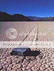
they look to me kinda like the 'rolling rocks' of death valley which are regularly found with huge trails in the sand (just like slugs but without
the slime!). here is a site discussing them, not a very good site mind, but at least you can get what I'm talking about!
Rolling Rocks
Rolling Rocks
Originally posted by zorgon
Originally posted by super70
Very well put phage, the most likely cause of the tracks.
Nice work fellows... Post rolling rocks then identify them as rolling rocks
The point was a seemingly anomalous occurrence posted for debate as to the cause of the object in question's tracks. That debate indeed took place and the logical scientific deduction resulted through intelligent analysis. Once again, thanks to the wealth of knowledge pooled by ATS members.
Originally posted by TheGreensGoblin
they look to me kinda like the 'rolling rocks' of death valley which are regularly found with huge trails in the sand (just like slugs but without the slime!). here is a site discussing them, not a very good site mind, but at least you can get what I'm talking about!
Well the Death Valley rocks do not ROLL across a FLAT plane... the current 'best guess' is that when the salt bed gets wet from run off the salt becomes slippery and the high winds in the area then move them..
But since no one has to date actually SEEN them move... its purely speculation.
So comparing this phenomena to the 'objects' on Mars is irrelevant and misleading
Then there is the one on the Moon that moves across depressions and goes uphill. This 'boulder' has been calculated to be 'house size' based on the pixel per kilometer data supplied with the original image...

The light colored area is the central peak... still lit by the sun, the dark area is the floor of the crater already in shadow...
Image number is LO-5-168... I am sure Phage has the LO resources at his fingertips to drag up the original
Then there are the tracks Mike Singh found some time ago


Found on the HiRISE image PSP_001415_1875
Enjoy
[edit on 30-9-2008 by zorgon]
Found on the HiRISE image PSP_001415_1875
Enjoy
[edit on 30-9-2008 by zorgon]
What kind of tracks are they zorgon? Does the rover leave such a signature or is it something else?
Originally posted by antar
What kind of tracks are they zorgon? Does the rover leave such a signature or is it something else?
The one on the Moon was before 1968 and the ones on Mars are nowhere near the current Rovers.
It is most certainly the TRACK PATTERN that is of interest here...
How does a rolling rock on Mars leave a figure 8 track?
How does a rolling rock the size of a house leaves such a regular strange pattern moving over hill and dale without missing a beat?
Yep I've been over that one Zorgon, thanks. That image is where I found "the building", you can find it at these coordinates:
X: 8981
Y: 15328
Check that one out, same JP2 image.
X: 8981
Y: 15328
Check that one out, same JP2 image.
reply to post by zorgon
aha, thanks for that Zorgon. You're right, upon reflection my post was misleading and irrelevant but it wasn't my intention, I was just making the point that this kind of thing is known to occur on Earth... But I am wrong, this is a very different matter. I had seen Singh's uphill images and the fig.8 but had never contemplated the fact that these trails must be HUGE!
Thanks for your response guys, I had never thought about the size of the boulders...the size of a HOUSE?!? WOW!!!
Argh, Zorgon, you are always keeping me up in the evening with your brilliant threads and posts. Rock ('n'Roll!) on dude.
Originally posted by chapter29
reply to post by Soylent Green Is People
so I can easily see a rock rolling downhill, then changing direction slightly as it encounters little mounds and valleys.
Question - if someone had said they could EASILY see the trail being created from a martian walking/driving around, wouldn't you take objection with that? Assumption here, but a good one I think...
I see other objects that look very similar in size and formation around the same vicinity; and I also take note with the angles and turns the "object' has taken. You would assume that if someone or something of higher intelligence did go for a drive or walk, why waste all that energy in going in so many different directions? Unless there was a martian party and someone forgot to lock up the rover...
So, one probable explanation is that it is indeed a rock that has been moved via nature...but nothing can be EASILY determined from the pictures we get.
Yes -- I would take exception to that.
1. We know Mars has rocks.
2. We know Mars has craters and hills
3. We know Mars has wind erosion
4. We know Mars has landslides (probes have documented landslides)
5. We know rocks occasionally roll down hills and craters on Mars.
So I think it's pretty safe to say that "I can easily see (meaning imagine) a rock rolling downhill, then changing direction slightly as it encounters little mounds and valleys."
We don't know (yet) of any Martians walking/driving around. I based my response on facts we know anout Mars.
[edit on 9/30/2008 by Soylent Green Is People]
Originally posted by TheGreensGoblin
reply to post by zorgon
aha, thanks for that Zorgon. You're right, upon reflection my post was misleading and irrelevant but it wasn't my intention, I was just making the point that this kind of thing is known to occur on Earth...
Hold on a sec, your post was far from irrelevant and misleading, i was also reminded of that, don't give the guy any undeserved praise, his point that it hasn't been seen is whats irrelevant, the fact is these rocks do move and the same can happen on mars, rocks can roll or slide under the right conditions, these images might be of interest to geologists but they show nothing of interest to do with the subject of this forum, remember logic and reason, the most likely answer is usually the right one and theres zero evidence that these tracks are created by anything other than rocks.
Thanks to super70 for having spotted yet again something of intriguing and difficult to spot: in my opinion he has a very good eye for spotting this
type of stuff and his finds are always worthy to be discussed.
The problem is the same once again: rolling boulders are the most likely explanation, even despite in the same photo we see other boulders drawing straight paths: the inclination of the terrain, the altitude of every single foot of terrain, are UNKNOWN. Both amount and relevance of unknown data rule out every chance to make any valid, a conclusive assessment on what we see.
What we would need in a case like this one is MOLA, but at the SAME resolution of HIRISE, and able to indicate even the variations of one foot, if not less:
MOLA (Mars Orbiter Laser Altimeter)
The Mars Orbiter Laser Altimeter (MOLA) on the Mars Global Surveyor is designed to map the martian global topography and can also be used to measure the height of water and carbon dioxide clouds. This information will be used for scientific objectives including:
Topographic maps produced by the Mars Orbiter Laser Altimeter (MOLA)
Tharsis hemisphere
www.astro.virginia.edu...
Hellas hemisphere
www.astro.virginia.edu...
Color coding is for altitude: blue is lowest, red high, white is highest:
Full res
High-resolution gravity draped over a shaded relief map of part of the northern hemisphere showing evidence for buried channels: (A) observed free-air gravity and (B) predicted gravity due to attraction of surface topography. The fact that (A) and (B) differ indicates that the gravity lows (in blue) in the northern lowlands shown in (A) are due to subsurface mass deficit. The plot is a Hammer projection from 30° S to 90° N latitude, 270° to 360° E longitude. North is at the top of each panel. Valles Marineris is the prominent feature at the lower left.
(Credit: MGS RS and MOLA Science Teams)
A mercator version of previous image. High-resolution gravity draped over a shaded relief map of part of the northern hemisphere showing evidence for buried channels: (TOP) observed free-air gravity and (BOTTOM) predicted gravity due to attraction of surface topography. The fact that the top and bottom figures differ indicates that the gravity lows (in blue) in the northern lowlands shown in the top frame are due to subsurface mass deficit. Valles Marineris is the prominent feature
at the lower left of each frame.
(Credit: MGS RS and MOLA Science Teams)
Documentation:
MOLA at Goddard Space Flight Center
Mission Experiment Gridded Data Records
Mars MOLA Viewer
AN OVERVIEW OF LITHOSPHERIC FLEXURE ON MARS: IMPLICATIONS OF INITIAL MOLA OBSERVATIONS (PDF).
now, after looking at a 2D image, we have ZERO chances to say for sure that what we see is a flat surface: and even knowing it, a straight pattern and a curved one in the same image may be the result of two different events occurred in two different situation, given also both the huge difference between Earthy and Martian gravity and the impossibility to calculate the Specific weight of what we see: not to mention what did originate the event. Of course to prove that what we see is all flat would almost (if not at all) rule out the boulder theory, but there's no way to prove it: with some Laser Altimeter results, (at the same resolution ) we could be way more precise, but what we can do so far is to guess: anyway, this is the strangest track i've seen so far, chicane included
[edit on 30/9/2008 by internos]
The problem is the same once again: rolling boulders are the most likely explanation, even despite in the same photo we see other boulders drawing straight paths: the inclination of the terrain, the altitude of every single foot of terrain, are UNKNOWN. Both amount and relevance of unknown data rule out every chance to make any valid, a conclusive assessment on what we see.
What we would need in a case like this one is MOLA, but at the SAME resolution of HIRISE, and able to indicate even the variations of one foot, if not less:
MOLA (Mars Orbiter Laser Altimeter)


The Mars Orbiter Laser Altimeter (MOLA) on the Mars Global Surveyor is designed to map the martian global topography and can also be used to measure the height of water and carbon dioxide clouds. This information will be used for scientific objectives including:
- 1) to study the surface processes on Mars, including the formation and evolution of volcanoes, basins, channels and the polar ice
caps;
- 2) combined with gravity and other data, to study the structure and evolution of the interior of Mars, including the lithospheric
thickness and strength, internal convection, composition, thermal history, and release of water and carbon dioxide to the surface;
- 3) to calculate the volume and seasonal changes in the polar ice deposits;
- 4) to measure the altitude and distribution of water and carbon dioxide clouds, for the purpose of constraining the
volatile budget in the martian atmosphere.
The MOLA works by transmitting a laser pulse down towards the surface. The pulse is reflected off the surface (or cloud) back to the instrument, where the return is detected. The two-way travel time is recorded, giving a measure of the distance between the spacecraft and the surface. Corrections are made to this distance based on atmospheric effects and accurate tracking of the spacecraft position allows an estimate of the surface altitude or cloud height. A large number of surface altimetry measurements will be taken, and combined to produce a global topographic map.
The MOLA consists of a diode pumped, Q-switched Nd:YAG laser transmitter with a pulse energy of 40-45 mJ. It can send continuous bursts of 10 pulses/sec, each pulse having a beam diameter of 1 cm and a divergence of 0.45 mrad. The reciever is a 50 cm parabolic antenna with a Si APD detector and four electronic filters (20, 60, 180, and 540 ns). The reciever field of view is 0.85 mrad with a 10 degree cone about the mirror exclusion. The vertical resolution is 2 m local (relative) and 30 m
global (absolute). The horizontal resolution is 160 m. The altimeter is run by a 80C86 microprocessor with 54HC family logic.
The altimeter is mounted to the Mars Global Surveyor instrument panel.
Topographic maps produced by the Mars Orbiter Laser Altimeter (MOLA)
Tharsis hemisphere

www.astro.virginia.edu...
Hellas hemisphere

www.astro.virginia.edu...
Color coding is for altitude: blue is lowest, red high, white is highest:

Full res

High-resolution gravity draped over a shaded relief map of part of the northern hemisphere showing evidence for buried channels: (A) observed free-air gravity and (B) predicted gravity due to attraction of surface topography. The fact that (A) and (B) differ indicates that the gravity lows (in blue) in the northern lowlands shown in (A) are due to subsurface mass deficit. The plot is a Hammer projection from 30° S to 90° N latitude, 270° to 360° E longitude. North is at the top of each panel. Valles Marineris is the prominent feature at the lower left.
(Credit: MGS RS and MOLA Science Teams)

A mercator version of previous image. High-resolution gravity draped over a shaded relief map of part of the northern hemisphere showing evidence for buried channels: (TOP) observed free-air gravity and (BOTTOM) predicted gravity due to attraction of surface topography. The fact that the top and bottom figures differ indicates that the gravity lows (in blue) in the northern lowlands shown in the top frame are due to subsurface mass deficit. Valles Marineris is the prominent feature
at the lower left of each frame.
(Credit: MGS RS and MOLA Science Teams)
Documentation:
MOLA at Goddard Space Flight Center
Mission Experiment Gridded Data Records
Mars MOLA Viewer
AN OVERVIEW OF LITHOSPHERIC FLEXURE ON MARS: IMPLICATIONS OF INITIAL MOLA OBSERVATIONS (PDF).
now, after looking at a 2D image, we have ZERO chances to say for sure that what we see is a flat surface: and even knowing it, a straight pattern and a curved one in the same image may be the result of two different events occurred in two different situation, given also both the huge difference between Earthy and Martian gravity and the impossibility to calculate the Specific weight of what we see: not to mention what did originate the event. Of course to prove that what we see is all flat would almost (if not at all) rule out the boulder theory, but there's no way to prove it: with some Laser Altimeter results, (at the same resolution ) we could be way more precise, but what we can do so far is to guess: anyway, this is the strangest track i've seen so far, chicane included
[edit on 30/9/2008 by internos]
Originally posted by just theory the fact is these rocks do move and the same can happen on mars, rocks can roll or slide under the right conditions,
Oh yes.. I am quite sure that we can get the same conditions on Mars for the rocks to slide around on wet salt... after all Spirit dug up a lot of salt flats
these images might be of interest to geologists but they show nothing of interest to do with the subject of this forum,
Umm the subject of this 'forum' at least this thread is moving objects most likely rocks...
reply to post by internos
All that to say the area is hilly and its most likely rocks rolling on uneven terrain?
Pretty colors in the pics though
Though personally I think its these guys messing with our heads

All that to say the area is hilly and its most likely rocks rolling on uneven terrain?
Pretty colors in the pics though
Though personally I think its these guys messing with our heads
Originally posted by zorgon
All that to say the area is hilly and its most likely rocks rolling on uneven terrain?
Ron, its purpose was just to show, roughly, the difference between a visual observation and an instrumental one That the one in the OP is an uneven terrain is a guess, because it's based on a visual observation, in top-view. A MOLA imageering would determine the actual conformation of the terrain, giving us the chance to explain the paths of all the boulders that we see. Basically we are guessing the conformation of the terrain basing our constructions on the boulders (or whatever they are) tracks, while it should work on the contrary ...
reply to post by zorgon
Perhaps we are not aware of everything that has been sent.
I mean.. its not unlike the governments to do secret missions and keep the public in the dark right?
We should always consider these things when we come across this sort of evidence.
Perhaps we are not aware of everything that has been sent.
I mean.. its not unlike the governments to do secret missions and keep the public in the dark right?
We should always consider these things when we come across this sort of evidence.
Originally posted by NephraTari
Perhaps we are not aware of everything that has been sent.
Now THAT is the 64 million dollar question...
It is also likely that if there was something they REALLY didn't want us to see... they would either..
A) Turn of the cameras
B) Have a 'glitch
C) Data 'loss' at a key moment
or
D) Just cover it up like they do on Google Earth
If THEY don't want you to see it... YOU WON'T
proof ya say? Why certainly
Internos will like this one too, as it involves his country
Here are some of the US Nuclear Arsenals OUTSIDE the USA

You will see Volkel Netherlands listed..
Go to Google Earth or Maps and have a look at how they cover things up they don't want you to see...
Volkel, Uden, The Netherlands
+51° 39' 33.29", +5° 41' 37.19"

I have many spots on Google that are covered like Wake Island and Johnston Atoll but THIS on has got to be the worst job ever... but its best case for coverup
[edit on 1-10-2008 by zorgon]
Fantastic information internos. Your consideration of every detail in your research never ceases to amaze. You certainly make your points well. The
data you provide shows sides of analysis that I never would have considered. A real credit to ATS!
Hi, well done OP for this thread.
Now there IS a photo that brings something:
Posted by Zorgon:
Given that the double track has limits, it can't be the rover's tracks, I deduct. Otherwise we'd see a continuation to it, it can't fly and land wherever it pleases, leave tracks and get teleported to elsewhere, OK?
So THAT IS INTERESTING.
The other track, CURVED: rocks do NOT roll 'down' in such a big and perfect curve. As pointed by Zorgon, I agree 100%, they do NOT do that.
So LOL for the previous forever-'logical' explanations to eveything by anything else. Well done Zorgon!
It needs a good look in fair edition. It seems, and not just for these tracks, that there is a relief, in height, not in depth, formed by a movement UNDER the GROUND, leaving shapes we call tracks, or, 'OVERTRACKS'. I only say it SEEMS before the usual quick hair-pullers pull.
So it COULD be, COULD, same precaution I use, that the 'something' that the skeptos call "ROCKS", TRAVELS UNDER, UNDERNEATH, like moles do, for a quick description of what I want to suggest.
By the way on some other examples, don't we get the feeling that the 'somethings' emerge from the ground? All those wholes, as they seem to be...I 've always said, and I'm far from alone in the idea, that it well could be an underground world there.
(Would you leave ON the ground when it's bombarded with asteroids etc and threatened, invaded by dust-storms?)
I'd like to see the full picture for the OP's first photo, to see where the thing which leaves a curved trajectory emerges from, if available.
If these travelling things are an animal-form, they are pretty geometry -minded!
[edit on 1-10-2008 by MarsFanMag]
Food for thoughts! I like your abvatar super70. I copied your photo , edited to put your name on+ATS.
Originally posted by super70
I'm 90% sure this is a rock, I have posted like images before. But when I find an object that seems to defy what like objects are doing in the same vicinity, I post it. My point was that the other objects left straight tracks over the same ground, and the object in question maneuvered multiple times. As you can see on "turn 1", the angle of direction turns extremely sharp. What did the object hit? There is no larger stone in its path, and the tracks left never jumped or had a noticeable impact on its very defined track. It seems to me that if indeed there were an impact against some solid object, that the track would be altered in a visible way. It simply "turned" and swirved, then turned again. I might mention that no obviouse hill is present on its downhill course.
Here is another object that I found and posted in the past...
Same remark, do you have the fuller photo, to see where the 'walking''creature' comes from?
new topics
-
Nearly 70% Of Americans Want Talks To End War In Ukraine
Political Issues: 7 minutes ago -
Late Night with the Devil - a really good unusual modern horror film.
Movies: 1 hours ago -
Cats Used as Live Bait to Train Ferocious Pitbulls in Illegal NYC Dogfighting
Social Issues and Civil Unrest: 3 hours ago -
The Good News According to Jesus - Episode 1
Religion, Faith, And Theology: 5 hours ago -
HORRIBLE !! Russian Soldier Drinking Own Urine To Survive In Battle
World War Three: 7 hours ago -
Bobiverse
Fantasy & Science Fiction: 10 hours ago -
Florida man's trip overseas ends in shock over $143,000 T-Mobile phone bill
Social Issues and Civil Unrest: 10 hours ago
top topics
-
Florida man's trip overseas ends in shock over $143,000 T-Mobile phone bill
Social Issues and Civil Unrest: 10 hours ago, 8 flags -
SETI chief says US has no evidence for alien technology. 'And we never have'
Aliens and UFOs: 14 hours ago, 7 flags -
Cats Used as Live Bait to Train Ferocious Pitbulls in Illegal NYC Dogfighting
Social Issues and Civil Unrest: 3 hours ago, 7 flags -
This is our Story
General Entertainment: 16 hours ago, 4 flags -
Former Labour minister Frank Field dies aged 81
People: 12 hours ago, 4 flags -
Bobiverse
Fantasy & Science Fiction: 10 hours ago, 3 flags -
Late Night with the Devil - a really good unusual modern horror film.
Movies: 1 hours ago, 2 flags -
HORRIBLE !! Russian Soldier Drinking Own Urine To Survive In Battle
World War Three: 7 hours ago, 2 flags -
The Good News According to Jesus - Episode 1
Religion, Faith, And Theology: 5 hours ago, 0 flags -
Nearly 70% Of Americans Want Talks To End War In Ukraine
Political Issues: 7 minutes ago, 0 flags
active topics
-
Nearly 70% Of Americans Want Talks To End War In Ukraine
Political Issues • 1 • : Disgusted123 -
British TV Presenter Refuses To Use Guest's Preferred Pronouns
Education and Media • 144 • : Consvoli -
Cats Used as Live Bait to Train Ferocious Pitbulls in Illegal NYC Dogfighting
Social Issues and Civil Unrest • 9 • : ImagoDei -
President BIDEN Vows to Make Americans Pay More Federal Taxes in 2025 - Political Suicide.
2024 Elections • 101 • : ImagoDei -
Late Night with the Devil - a really good unusual modern horror film.
Movies • 3 • : Hecate666 -
HORRIBLE !! Russian Soldier Drinking Own Urine To Survive In Battle
World War Three • 23 • : Disgusted123 -
Hi folks I'm Leon Grad
Introductions • 9 • : leongrad -
The Reality of the Laser
Military Projects • 41 • : 5thHead -
Thousands Of Young Ukrainian Men Trying To Flee The Country To Avoid Conscription And The War
Other Current Events • 136 • : NorthOS -
Florida man's trip overseas ends in shock over $143,000 T-Mobile phone bill
Social Issues and Civil Unrest • 16 • : grey580