It looks like you're using an Ad Blocker.
Please white-list or disable AboveTopSecret.com in your ad-blocking tool.
Thank you.
Some features of ATS will be disabled while you continue to use an ad-blocker.

Water on mars see for yourself to believe it!!!
page: 1share:
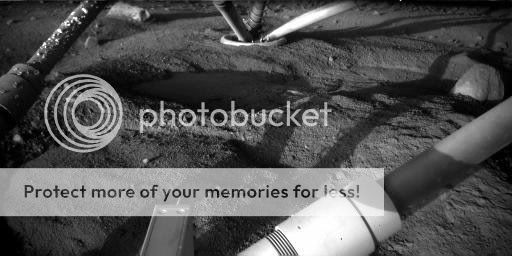
Hi everyone came across this in the HIRISE images collection it is titled, "Dark Spot Near Olypmus Mons Volcano".
The image was apparently taken near the olympus mons volcano, the largest volcano in the solar system, and it is inactive one, and in the image, there is this blue lake, though NASA release states that it is basaltic sand or dust free bedrock, it doesnt look like that all, the image clearly shows liquid water and also the proximity to the volcano suggests that the water might have been collected through the crater.
Here's the link, see for yourself,
hirise.lpl.arizona.edu...
The image was apparently taken near the olympus mons volcano, the largest volcano in the solar system, and it is inactive one, and in the image, there is this blue lake, though NASA release states that it is basaltic sand or dust free bedrock, it doesnt look like that all, the image clearly shows liquid water and also the proximity to the volcano suggests that the water might have been collected through the crater.
These dark spots are distinctive because much of the surrounding area appears to be covered by light-toned dust. In pre-HiRISE images, the origin of this dark spot was ambiguous. This HiRISE image reveals that the dark color is likely the result of accumulations of basaltic sand (smooth, blue-colored material in the color swath) on top of otherwise relatively dust-free bedrock.
Here's the link, see for yourself,
hirise.lpl.arizona.edu...

it's not water.... apart from looking at the picture below and realising that when water is laid down on a surface it remains flat. the bottom of the
picture looks like a huge wave there but is actually raised ground...
As quoted from the website that you provided: which im guessing you didn't read.
hirise.lpl.arizona.edu...
"This image covers a relatively dark-toned patch of ground west of the Olympus Mons volcano. This spot is one of several dark areas in this region of Mars.
These dark spots are distinctive because much of the surrounding area appears to be covered by light-toned dust. In pre-HiRISE images, the origin of this dark spot was ambiguous. This HiRISE image reveals that the dark color is likely the result of accumulations of basaltic sand (smooth, blue-colored material in the color swath) on top of otherwise relatively dust-free bedrock."
reply to post by DaRAGE
I see your point, but just look below the upper rock and you will see that the sand is distributed in the form of waves, and if it is only sand why is its colour instensity different at various points, it should have been even,
I see your point, but just look below the upper rock and you will see that the sand is distributed in the form of waves, and if it is only sand why is its colour instensity different at various points, it should have been even,
Just to let you know, neither the shades of gray or the blue in that picture are the true real color. It's some sort of camera mode that makes it
out to be like that. So if you were basing your decision on the color, then rethink it.
Whether or not that's water is a topic i don't really care for, besides, wasn't it confirmed a few weeks back that they have found frozen water on mars with the phoenix lander? Maybe my memory is messing me up.
Whether or not that's water is a topic i don't really care for, besides, wasn't it confirmed a few weeks back that they have found frozen water on mars with the phoenix lander? Maybe my memory is messing me up.
Oh come on guys please do post your opinion regarding this, I am waiting for your replies.
To be honest, to me, it doesn't look like water, I can't help noticing a 'grained effect' on it, yet for all I know, NASA has photoshopped this
bad boy, afterall, what was photoshop invented for?
The waves also seem to be 'wind disturbances' on the sand, they're to far apart to be waves I think, although, I'm probably wrong.
I do think there is water on Mars, and possibly alot more, but IMO, this isn't conclusive, could be, but it may not be aswell, the colours are beautiful though. IF you want to see water on Mars, have a look at this, seems to be a puddle underneath the Rover?:
I'm sure this has been shown before but oh well.
EMM
Edit to add: If this was water, I doubt NASA would leave it blue, they would hue it with red, so as to divert attention, the fact that it is blue makes me question.
[edit on 27-9-2008 by ElectroMagnetic Multivers]
Although I am not qualified or smart enough to make an indepth analysis of this pic. Even NASA has said Mars was once a water world.
To believe pockets still exist is not outside the realm of imagination.
To believe pockets still exist is not outside the realm of imagination.
reply to post by peacejet
Why should the color be even?
On Mars (and on Earth) there are many places that dust and soil deposits are darker in some places than in other places -- i.e. not all dirt is the same color.
Plus, he sand you said is distributed in the form of waves simply looks like parallel sand dunes -- the type that are very common on Mars.
So besides the fact that the picture is blue (which is false color, by the way -- blue is often used in fasle color images because it contrasts well with the browns and yellow) I don't see any evidence that is a picture of water.
I know it was proven that water ice exists on Mars, but water itself would sublimate away due to the low atmospheric pressures.
[edit on 9/27/2008 by Soylent Green Is People]
Originally posted by ElectroMagnetic Multivers
Edit to add: If this was water, I doubt NASA would leave it blue, they would hue it with red, so as to divert attention, the fact that it is blue makes me question.
Yes, I accept your opinion, but it looked so much like water, and had me amazed for a moment, thats why I posted it here.
Originally posted by jpm1602
To believe pockets still exist is not outside the realm of imagination.
Yes, there is a possibility, and the close proximity to the extinct olympus mons suggest that if it is water, it might be a overflow of water from the crater caught in the form of the reservoir between the two mountains, and it sure looks more like a lake seeing that the bottom half is more in slope than the top half.
Originally posted by Soylent Green Is People
reply to post by peacejet
I know it was proven that water ice exists on Mars, but water itself would sublimate away due to the low atmospheric pressures.
[edit on 9/27/2008 by Soylent Green Is People]
Liquid water is found during the early morning times when the temperature is a lot cooler as you would have seen in the phoenix mission images of the liquid water and frost forming in the early morning time, and considering that it is near olympus mons and it is higher than the plains the temperature if a lot cooler and can allow water to exist without evaporating.
I'm one to think Mars is abundant with water, but in this case, I don't think we are looking at water.
Pros:
-The "wave-like" eroded sand.
-The small rock inside the dark blue, just above the lower large rock.
-It's blue. Although false color, it kind of makes the mind think water.
Cons:
-It's blue! Although false color, NASA wouldn't make it so easy. Usually when water is pictured, they turn it to sand.
-Where's the source/s?
-The other so-called dark spots in the image.
-Did I mention it's blue?
That's my take. Thanks for posting. Flagged.
When looking for water I think we should also remember that the gravity on mars is lower compared to earth. How would this affect how the water
behaves?
www.marsanomalyresearch.com...
Note that the interior contents of these two depressions are a very light and very bright color. One might assume that this may be because of the presence of highly reflective ice conditions. Such an assumption would conveniently in turn enable the perception and following arguments that this ice is probably CO2 ice. However that just isn't the case here. Note that the flat level interior surface and the obvious narrow band of sloped bare shore between the true liquid waterline and the darker background shore as pointed out by my labeling are both very light color. In my opinion, this is because of an application of light color semitransparent (opaque) smudge image tampering was mapped and applied equally to both the bare sloped shore narrow band and the flat water surface together.
Now, if it had been applied thick enough in enough layers, the evidence of flat level liquid waterline as differentiated from the narrow band of sloped shore evidence would have been merged together and eliminated. That is typical of how effectively obscuring water sites goes in this planetary Mars imaging as it has been released to us. Fortunately for us liquid water depth because of its transparency absorbs more light than it reflects and is normally a darker color preserving the water here as a very slightly darker color and thereby the faintly seen waterline demarcation line effect is preserved. Also, the narrow band of reflective sloped shore as above water terrain was already a lighter reflective color in the natural sunlight. So the tampering application made it even lighter maintaining to some extent the contrast difference between the water and narrow band of sloped shore to preserve the irregular waterline demarcation line.
This type of tampering is typical of how the visuals of the natural visual qualities of liquid surface water are hidden from view in the Mars satellite science data imaging. I have seen a great many much more effective applications, especially around and on the South Polar Cap itself. Most of the time these applications are successful at merging the water and shore into a false single flattened visual effect intended to and relatively effectively mimicking an ice field, at least as it appears in the compromised quality distant satellite imaging as released to us. Remember, if it can be made to appear to be solid form ice, then it can in turn be argued that it is CO2 ice rather than water ice. At the very least, doubt is introduced and, when in doubt, who are you going to believe a lone individual like me or the whole scientific world?
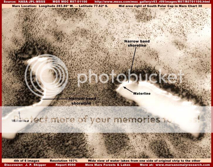

The photos are tampered with before they reach our eyes, and Nasa attempts to make us conclude standing water is co2 ice. There are many analysts that catch these things.
Then there's the forest....
[edit on 27-9-2008 by mystiq]
new topics
-
Ditching physical money
History: 2 hours ago -
One Flame Throwing Robot Dog for Christmas Please!
Weaponry: 2 hours ago -
Don't take advantage of people just because it seems easy it will backfire
Rant: 2 hours ago -
VirginOfGrand says hello
Introductions: 3 hours ago -
Should Biden Replace Harris With AOC On the 2024 Democrat Ticket?
2024 Elections: 4 hours ago -
University student disciplined after saying veganism is wrong and gender fluidity is stupid
Education and Media: 6 hours ago -
Geddy Lee in Conversation with Alex Lifeson - My Effin’ Life
People: 7 hours ago -
God lived as a Devil Dog.
Short Stories: 8 hours ago -
Police clash with St George’s Day protesters at central London rally
Social Issues and Civil Unrest: 9 hours ago -
TLDR post about ATS and why I love it and hope we all stay together somewhere
General Chit Chat: 10 hours ago
top topics
-
Hate makes for strange bedfellows
US Political Madness: 12 hours ago, 19 flags -
Who guards the guards
US Political Madness: 15 hours ago, 13 flags -
University student disciplined after saying veganism is wrong and gender fluidity is stupid
Education and Media: 6 hours ago, 12 flags -
Police clash with St George’s Day protesters at central London rally
Social Issues and Civil Unrest: 9 hours ago, 9 flags -
TLDR post about ATS and why I love it and hope we all stay together somewhere
General Chit Chat: 10 hours ago, 7 flags -
Should Biden Replace Harris With AOC On the 2024 Democrat Ticket?
2024 Elections: 4 hours ago, 5 flags -
Has Tesla manipulated data logs to cover up auto pilot crash?
Automotive Discussion: 17 hours ago, 3 flags -
God lived as a Devil Dog.
Short Stories: 8 hours ago, 3 flags -
Don't take advantage of people just because it seems easy it will backfire
Rant: 2 hours ago, 3 flags -
One Flame Throwing Robot Dog for Christmas Please!
Weaponry: 2 hours ago, 2 flags
active topics
-
Hate makes for strange bedfellows
US Political Madness • 37 • : YourFaceAgain -
Candidate TRUMP Now Has Crazy Judge JUAN MERCHAN After Him - The Stormy Daniels Hush-Money Case.
Political Conspiracies • 742 • : Annee -
Ditching physical money
History • 11 • : BernnieJGato -
Should Biden Replace Harris With AOC On the 2024 Democrat Ticket?
2024 Elections • 35 • : budzprime69 -
1980s Arcade
General Chit Chat • 24 • : 5thHead -
Don't take advantage of people just because it seems easy it will backfire
Rant • 4 • : VirginOfGrand -
The Superstition of Full Moons Filling Hospitals Turns Out To Be True!
Medical Issues & Conspiracies • 21 • : VirginOfGrand -
-@TH3WH17ERABB17- -Q- ---TIME TO SHOW THE WORLD--- -Part- --44--
Dissecting Disinformation • 633 • : Justoneman -
VirginOfGrand says hello
Introductions • 1 • : VirginOfGrand -
Gold and silver prices....woo hoo
History • 84 • : annonentity