It looks like you're using an Ad Blocker.
Please white-list or disable AboveTopSecret.com in your ad-blocking tool.
Thank you.
Some features of ATS will be disabled while you continue to use an ad-blocker.

Actual C-130 Interaction With The Pentaplane helps reveal the TRUE flight path.
page: 2share:
Originally posted by Boone 870
O'Brien did not state how far past the mall he was. Also, he did not state how far south of the mall he was.
He states he was passed the mall headed westbound after traveling north and west. This is not what the RADES data shows.
You're using nonspecific information to make specific claims. All the statements O'Brien made were relative to his position during the flight.
You are interpreting his words to match your theory.
Huh? That is what YOU are doing by ignoring the fact that he says north and west while the RADES data shows southwest.
North and west is VERY specific.
How could he be any more specific?
Just because you don't believe that a 4-5 mile vantage point from an aircraft can be considered a ''wonderful veiw'' doesn't mean that O'Brien should have been right above the mall to have that veiw.
It's the reference point he uses after having traveled north and west.
If he traveled southwest he would not use the mall as a reference point plus if his view of the mall from 5 or 6 miles away traveling southwest was so great his view of the plane coming directly in front of him at 9:34:25 would be even better.
North and west. Two separate words, two separate directions. You are the one that believes he flew northwest. He departed to the north and then flew west.
GREEN=Northwest flightpath
RED=Actual flightpath
BLUE=West
WHITE=Southwest
Red and white are both southwest.
Blue is west.
But O'Brien says he traveled NORTH and west.
Blue is northwest.
Red is north and west.
Both end up south of the mall.
You ignore the FACT that he says north when the RADES data shows the opposite.
The two yellow thumbtacks represent positions from the radar data. As you can see by the redline, Gopher06 flew closer to west than it did to the southwest.
But he says he flew north and west.
Why do you keep ignoring what he says and stating there is no contradiction?
Originally posted by Zaphod58
As to the visibility question, you're lucky to see a 747 at two-three miles when it's on final approach sometimes. Seeing a 757 at beyond 4-5 miles, with no aid to help you other than a rough area to look is all but impossible. A 757 is NOT a large aircraft. It's a narrow body which makes it even harder if it's in a head on approach to you.
Ok got it.
So then there is no way he would have a beautiful view of the mall according to the RADES data.
Originally posted by Zaphod58
As Seeing a 757 at beyond 4-5 miles, with no aid to help you other than a rough area to look is all but impossible.
You see zaphod.....according to the X that Boone made O'Brien would have been about 5 miles from the plane at that point.
In fact there is never a point where he is closer than 5 miles according to the data.
So basically you are suggesting that it's impossible for him to have seen the plane.
But I don't disagree with your assertion. He was likely much closer to the plane when he saw it north of the Pentagon and Potomac River just after he had passed the mall traveling westbound.
You simply help prove why the RADES data is irreconcilable with O'Brien's account.
Thanks for your expert input.
[edit on 9-12-2007 by Craig Ranke CIT]
What I said was that BEYOND four to five miles it would have been almost impossible to see it, depending on the angle it was coming at them.
If it was in a head on approach to the C-130 it would have been a tiny little black speck heading towards them. IF however it was coming from one
side of them, crossing to the other, they would have had a slightly easier time in finding it, even though it still would have been hard to find.
Five miles is about as far as I would say you could see a 757 on a beautiful day.
How can you say that they were never closer than five miles according to the RADES data? It sure looks like they were a lot closer than five miles going by the flight paths of both aircraft, as flight 77 is turning around to line up. Gopher 06 is right over the top of him.
How can you say that they were never closer than five miles according to the RADES data? It sure looks like they were a lot closer than five miles going by the flight paths of both aircraft, as flight 77 is turning around to line up. Gopher 06 is right over the top of him.
Originally posted by Zaphod58
How can you say that they were never closer than five miles according to the RADES data? It sure looks like they were a lot closer than five miles going by the flight paths of both aircraft, as flight 77 is turning around to line up. Gopher 06 is right over the top of him.
Regardless.....the data shows him about 5 miles away when Boone claims he first saw the plane and it shows him NOWHERE near the mall let alone just passing it going westbound like he says.
No matter how you slice it he says he flew north and west to the south side of the mall and first saw the plane after passing the mall going westbound.
That is nothing like the southwest path that the RADES data shows.
Wouldn't you agree?
[edit on 9-12-2007 by Craig Ranke CIT]
reply to post by Craig Ranke CIT
North and west is not very specific.
Every airplane has a heading indicator. The heading indicator is labeled with degrees. 010, 020, 030, and so on..... until you get back to 360 which is north. East is 090, South is 180, West is 270. I don't believe that the heading indicator even has the east, south, west, or north label on them.
If he was being specific, he would have given a number for his heading instead of north and west.
He wasn't giving or receiving headings from ATC during the interview, he used north and west as a layman's term.
If you think north and west is very specific in the aviation universe, then go to this web site www.liveatc.net and listen to the live feeds and then come back and tell me that north and west is specific.
O'Brien said:
How long is "just after" to you? Two seconds? Two minutes?
White is southwest. Blue is west. Red is westsouthwest, which is closer to west that it is southwest.
North and west is VERY specific.
How could he be any more specific?
North and west is not very specific.
Every airplane has a heading indicator. The heading indicator is labeled with degrees. 010, 020, 030, and so on..... until you get back to 360 which is north. East is 090, South is 180, West is 270. I don't believe that the heading indicator even has the east, south, west, or north label on them.
If he was being specific, he would have given a number for his heading instead of north and west.
He wasn't giving or receiving headings from ATC during the interview, he used north and west as a layman's term.
If you think north and west is very specific in the aviation universe, then go to this web site www.liveatc.net and listen to the live feeds and then come back and tell me that north and west is specific.
O'Brien said:
Our first sighting of the AA flight was just after we had gone by the mall westbound.
How long is "just after" to you? Two seconds? Two minutes?
GREEN=Northwest flightpath
RED=Actual flightpath
BLUE=West
WHITE=Southwest
originally posted by Craig Ranke
Red and white are both southwest.
White is southwest. Blue is west. Red is westsouthwest, which is closer to west that it is southwest.
reply to post by Boone 870
"westsouthwest"?
Bro.......O'Brien says he traveled north and west to the south side of the mall which is in fact northwest of Andrews.
The RADES data shows no such thing.
The RADES data says he traveled southwest.
This is not what he says.
You are resorting to making up cardinal points like "westsouthwest" and dismissing others like "north" in order to continue this discussion without conceding.
Please answer the following questions with yes or no answers.
Do you agree that O'Brien claims he traveled north and west?
Do you agree that the RADES data shows him traveling southwest?
reply to post by Craig Ranke CIT
Yes
No
I have already shown that the flight path was closer to West then it was southwest.
The radar data map that shows the C-130 flight path is not oriented north.
I re-created the flight path on a map that was oriented north. Why do you keep saying Southwest?
Did you look at the air traffic control link I posted? How many times did you hear a controller issuing directions using North, East, South, or West?
How long is "just after" to you?
How far is"south of the mall" to you? 20 feet? 2 miles?
Do you agree that O'Brien claims he traveled north and west?
Do you agree that the RADES data shows him traveling southwest?
Yes
No
I have already shown that the flight path was closer to West then it was southwest.
The radar data map that shows the C-130 flight path is not oriented north.
I re-created the flight path on a map that was oriented north. Why do you keep saying Southwest?
Did you look at the air traffic control link I posted? How many times did you hear a controller issuing directions using North, East, South, or West?
How long is "just after" to you?
How far is"south of the mall" to you? 20 feet? 2 miles?
Craig, it is like the feeling one gets when discussing the Towers truning into dust: You want to tear your hair out in frustration because some people
just CANNOT GET IT!! When you have donw the work and nailed down a point and it MEANS something to the world, you expect a little enthusiasm and
agreement, even if some details remain to be ironed out.
But as I read all this you work all the time putting this together and I just hope that the people will study it and take it to heart. If south is south and west is west then the official story is ONCE again proved a lie. I applaud your effrrots and I agre with many of your premises..and for sure the flight paths are a critical key to the crime. Good work!!
But as I read all this you work all the time putting this together and I just hope that the people will study it and take it to heart. If south is south and west is west then the official story is ONCE again proved a lie. I applaud your effrrots and I agre with many of your premises..and for sure the flight paths are a critical key to the crime. Good work!!
Originally posted by Boone 870
reply to post by Craig Ranke CIT
Do you agree that O'Brien claims he traveled north and west?
Do you agree that the RADES data shows him traveling southwest?
Yes
Ok then do you claim that the RADES data shows him traveling north after take off?
No
I have already shown that the flight path was closer to West then it was southwest.
The radar data map that shows the C-130 flight path is not oriented north.
I re-created the flight path on a map that was oriented north. Why do you keep saying Southwest?
Because it is STILL southwest even when oriented perfectly to north.
Are you really denying this?
Are you suggesting that there is only one angle that is southwest?
I don't get it.
Do you really think that "westsouthwest" is even a word?
Please explain.
Did you look at the air traffic control link I posted? How many times did you hear a controller issuing directions using North, East, South, or West?
What does that have to do with the fact that O'Brien used those terms?
You already agreed that he says north and west.
The RADES data does not depict this which right away proves a contradiction between the two.
How long is "just after" to you?
How far is"south of the mall" to you? 20 feet? 2 miles?
Doesn't matter.
Point is he says he was headed westbound (not southwest) and was at the south side of the mall after traveling north and west from Andrews.
The RADES data shows no such thing
reply to post by eyewitness86
Thanks.
It's quite refreshing to hear from someone with basic common sense.
Thanks.
It's quite refreshing to hear from someone with basic common sense.
reply to post by Craig Ranke CIT
Yes. For a short amount of time.
It has everything to do with this conversation.
I suggested that north and west was vague.
You said that they were very specific.
I said no they weren't. If O'Brien was being specific, he would have given heading numbers.
Then I posted a link that has live air traffic control transmissions and asked you to listen to the controllers and report back telling me how many times you heard the terms north, east, south, or west when the controllers were telling the aircraft what direction to head.
Did you go to the link and listen to the controllers?
Yes it does matter. Your interpretation of those phrases is the basis of your proof that the RADES data was fabricated to fit the official story.
Ok then do you claim that the RADES data shows him traveling north after take off?
Yes. For a short amount of time.
Are you suggesting that there is only one angle that is southwest?
I don't get it.
Do you really think that "westsouthwest" is even a word?
Please explain.
Dictionary.com
a point on the compass midway between west and southwest.
What does that have to do with the fact that O'Brien used those terms?
You already agreed that he says north and west.
It has everything to do with this conversation.
I suggested that north and west was vague.
You said that they were very specific.
I said no they weren't. If O'Brien was being specific, he would have given heading numbers.
Then I posted a link that has live air traffic control transmissions and asked you to listen to the controllers and report back telling me how many times you heard the terms north, east, south, or west when the controllers were telling the aircraft what direction to head.
Did you go to the link and listen to the controllers?
Doesn't matter.
Yes it does matter. Your interpretation of those phrases is the basis of your proof that the RADES data was fabricated to fit the official story.
I stand corrected in the notion that westsouthwest isn't a word.
I guess I never heard it referred to as that.
But my point is still 100% correct.
O'Brien claims he traveled north and west to the south side of the mall.
The RADES data shows him traveling westsouthwest.
That is a direct contradiction and adds to the multiple independent sources of evidence we have proving the RADES and NTSB data fraudulent.
reply to post by Craig Ranke CIT
I have to disagree.
O'Brien didn't claim that he traveled north and west to the south side of the mall. He said, "which took us by the south side of the mall".
The next time you go to Washington, DC, head over to the local airport and spend a hundred bucks for a scenic flight and ask the pilot to fly you as close to the mall as he can get. Take notes on how far away you can see it.
But my point is still 100% correct.
O'Brien claims he traveled north and west to the south side of the mall.
I have to disagree.
O'Brien didn't claim that he traveled north and west to the south side of the mall. He said, "which took us by the south side of the mall".
The next time you go to Washington, DC, head over to the local airport and spend a hundred bucks for a scenic flight and ask the pilot to fly you as close to the mall as he can get. Take notes on how far away you can see it.
Originally posted by Boone 870
reply to post by Craig Ranke CIT
But my point is still 100% correct.
O'Brien claims he traveled north and west to the south side of the mall.
I have to disagree.
O'Brien didn't claim that he traveled north and west to the south side of the mall. He said, "which took us by the south side of the mall".
That is the the same thing.
Are you now going to deny what the word "to" means?
The south side of the mall is north and west from Andrews.
The RADES flight path is NOT.
The next time you go to Washington, DC, head over to the local airport and spend a hundred bucks for a scenic flight and ask the pilot to fly you as close to the mall as he can get. Take notes on how far away you can see it.
It doesn't matter how far away it is possible to see it.
He doesn't say....."and I was able to see the mall in the distance."
He says he went north and west to the south side of the mall.
He does not say he went westsouthwest to the RADES flight path.
He would not say "which took us to the south side of the mall" if he was way south of the River and the Pentagon headed in a different direction!
The fact that you will attempt to argue this is blowing my mind.
reply to post by Craig Ranke CIT
The fact that you use the above quotes to end up with this map-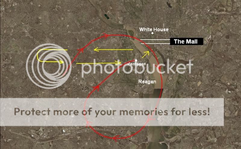 -is
blowing mine!
-is
blowing mine!
Why do you have the C-130 turning left in the above image?
originally posted by Craig Ranke
The fact that you will attempt to argue this is blowing my mind.
Steve O'Brien
"When we took off, we headed north and west and had a beautiful view of the Mall,"
"I noticed this airplane up and to the left of us, at 10 o'clock. He was descending to our altitude, four miles away or so."
"we turned back to the east to follow it per a request from Wash. Departure Control."
The fact that you use the above quotes to end up with this map-
Why do you have the C-130 turning left in the above image?
Originally posted by Boone 870
Why do you have the C-130 turning left in the above image?
Why not?
He could have turned left or right to go back "east" after heading "west" and nothing changes.
Either way he is describing doing a U-turn to try and locate the plane again per ATC's request.
But at that point, after he turned around, he saw the explosion and was too far away to be able to tell that it came from the Pentagon let alone see the plane hit.
reply to post by Craig Ranke CIT
Because the radar data shows him turning right. You are claiming that the radar data is fake, why would they show him turning to the left rather than the right?
Why not?
Because the radar data shows him turning right. You are claiming that the radar data is fake, why would they show him turning to the left rather than the right?
Originally posted by Boone 870
Because the radar data shows him turning right. You are claiming that the radar data is fake, why would they show him turning to the left rather than the right?
Now you are confusing right and left.
I really don't get your point.
The radar data shows something completely different from what he describes.
He went NORTH and west to the south side of the mall.
That is not westsouthwest.
reply to post by Craig Ranke CIT
Why do you have him turning left in your diagram of what you thought the flight path should be? What makes you think he turned to the left instead of to the right?
Why do you have him turning left in your diagram of what you thought the flight path should be? What makes you think he turned to the left instead of to the right?
new topics
-
An Apology From the Dunderbeck Sausage Company
Music: 1 hours ago -
Tucker on Joe Rogan talking Kona Blue and UFOs
Aliens and UFOs: 2 hours ago -
Remember These Attacks When President Trump 2.0 Retribution-Justice Commences.
2024 Elections: 2 hours ago -
Predicting The Future: The Satanic Temple v. Florida
Conspiracies in Religions: 3 hours ago -
WF Killer Patents & Secret Science Vol. 1 | Free Energy & Anti-Gravity Cover-Ups
General Conspiracies: 5 hours ago -
Hurt my hip; should I go see a Doctor
General Chit Chat: 5 hours ago -
Israel attacking Iran again.
Middle East Issues: 7 hours ago -
Michigan school district cancels lesson on gender identity and pronouns after backlash
Education and Media: 7 hours ago -
When an Angel gets his or her wings
Religion, Faith, And Theology: 8 hours ago -
Comparing the theology of Paul and Hebrews
Religion, Faith, And Theology: 8 hours ago
top topics
-
The Democrats Take Control the House - Look what happened while you were sleeping
US Political Madness: 13 hours ago, 18 flags -
In an Historic First, In N Out Burger Permanently Closes a Location
Mainstream News: 15 hours ago, 16 flags -
Biden says little kids flip him the bird all the time.
Politicians & People: 12 hours ago, 9 flags -
Man sets himself on fire outside Donald Trump trial
Mainstream News: 12 hours ago, 9 flags -
WF Killer Patents & Secret Science Vol. 1 | Free Energy & Anti-Gravity Cover-Ups
General Conspiracies: 5 hours ago, 7 flags -
Michigan school district cancels lesson on gender identity and pronouns after backlash
Education and Media: 7 hours ago, 7 flags -
Pentagon acknowledges secret UFO project, the Kona Blue program | Vargas Reports
Aliens and UFOs: 9 hours ago, 6 flags -
Israel attacking Iran again.
Middle East Issues: 7 hours ago, 5 flags -
Remember These Attacks When President Trump 2.0 Retribution-Justice Commences.
2024 Elections: 2 hours ago, 5 flags -
Boston Dynamics say Farewell to Atlas
Science & Technology: 9 hours ago, 4 flags
active topics
-
Michigan school district cancels lesson on gender identity and pronouns after backlash
Education and Media • 10 • : Freeborn -
Israel attacking Iran again.
Middle East Issues • 31 • : Freeborn -
MULTIPLE SKYMASTER MESSAGES GOING OUT
World War Three • 57 • : SchrodingersRat -
Man sets himself on fire outside Donald Trump trial
Mainstream News • 45 • : ByeByeAmericanPie -
The Democrats Take Control the House - Look what happened while you were sleeping
US Political Madness • 69 • : Astyanax -
The Good News According to Jesus
Religion, Faith, And Theology • 4 • : randomuser2034 -
Are you ready for the return of Jesus Christ? Have you been cleansed by His blood?
Religion, Faith, And Theology • 22 • : glend -
Predicting The Future: The Satanic Temple v. Florida
Conspiracies in Religions • 7 • : randomuser2034 -
Tucker on Joe Rogan talking Kona Blue and UFOs
Aliens and UFOs • 1 • : NoCorruptionAllowed -
An Apology From the Dunderbeck Sausage Company
Music • 0 • : TheMichiganSwampBuck