It looks like you're using an Ad Blocker.
Please white-list or disable AboveTopSecret.com in your ad-blocking tool.
Thank you.
Some features of ATS will be disabled while you continue to use an ad-blocker.

Pentagon "NTSB animation" is wrong!
page: 17share:
Originally posted by scrapple
NTSB to make a perfect forgery would want to 'rotate the map' clockwise ~10* through the center of the Pentagon (figuratively) to match their story of the strike run......and do so slowly over the course of the flight's simulation so that they are not initially shown taking off in a farmer's field at Dulles.
Originally posted by nick7261
In fact, it seems to me more likely just the opposite of what you said. It looks more like somebody wanted to show the flight path coming in VISUALLY north of the Citgo so the map was rotated counter-clockwise on the approach to the Pentagon.
Yes - but in your twist scenario the forgers (who may be cohorts with a quasi-professional pilots group) twists the terrain “opposite” of their sacred “TRUE VIRGINS MAKE DULL COMPANIONS and East is Least, West is Best” rule?
This seems an unlikely scenario to me.
Im very new to photoshop so i dont know how to rotate layers yet...
But it is clear if you rotate the the bottom picture to the same orientation as the top.. it is clear the pentgon is not rotated itself in P4T picture... nice try Nicky.. i'll expect your retraction anytime now..
typos
[edit on 8-6-2007 by johndoex]
But it is clear if you rotate the the bottom picture to the same orientation as the top.. it is clear the pentgon is not rotated itself in P4T picture... nice try Nicky.. i'll expect your retraction anytime now..
typos
[edit on 8-6-2007 by johndoex]
Originally posted by johndoex
Try lining them both up in the same orientation first my friend.
Exactly!
Originally posted by nick7261
Rob has shown me nothing to make me believe that he actually can authenticate that the animation came from the NTSB. He is now referencing a poster on the JREF forum named SLOB that supposedly put up his own animation file that matches P49T's animation file. SLOB registered on JREF in Oct. 2006, about 1 month after P49T.org was registered, and about 1 month before pentacon.com was registered. The link to download SLOB's animation only shows that the animation has been downloaded 1 time. I tried downloading it and it didn't work.
I'm presuming the torrent channel was only working long enough to get it on Google, and that that is the one posted May 26. It's the same animation, or in other words, Pandora's Black Box Chapter 1 sans credits. Unfortunately, its previous dissemination by definition casts doubt on all future re-posts of this animation.
We are in mystery land. No proof either way, just cirumstantial evidece.
Good finds, Nick. Regarding this one:
Rob then became angry at anybody who disagreed with him and challenged the authenticity of what he was claiming, and began banning people from his P49T forum who questioned him. He even ignored UnderTow's request to get some sort of time stamp off the data file from the NTSB animation CD, claiming that the time stamp was contained in the animation itself.
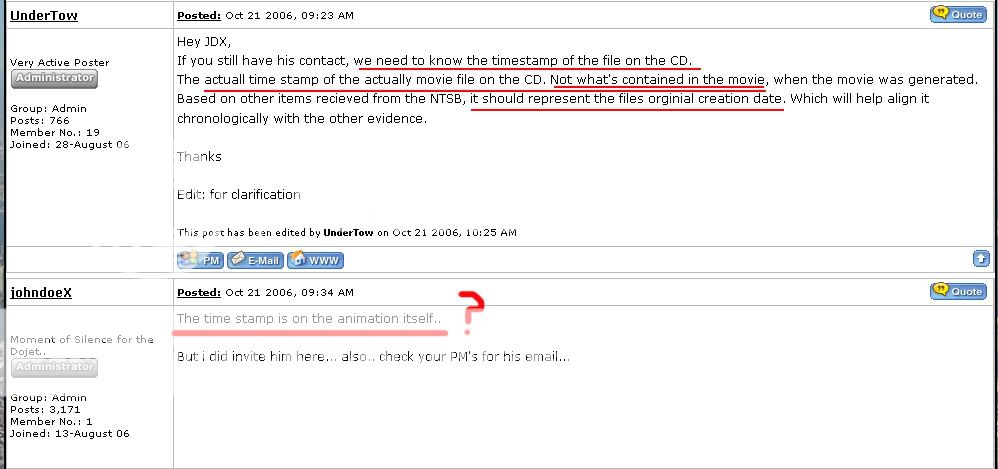
The created date is IN the animation? At what point? Possibly just a message board misuderstanding, he didn't see your double-underline... But where is the created date and what is it?
(BTW For what it's worth, Undertow at least seems pretty honest from what I've seen.)
[edit on 8-6-2007 by UM_Gazz]
edit to fix italics and bold my main thots, sorry for misunderstanding
[edit on 8-6-2007 by Caustic Logic]
Originally posted by johndoex
Im very new to photoshop so i dont know how to rotate layers yet...
Simple
highlight layer you are working on
'edit' pull down
'transform' tab
'rotate'
-scrap
If Nicky would do his homework.. he would find the same FULL photo i used for that crop at our website pentagon page in the right margin.. which also
has a Compass in the picture!
pilotsfor911truth.org...
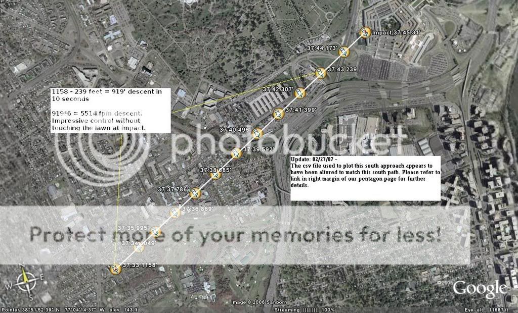
(click the link in right margin that say "Final Approach Path". It was made with csv file headings prior to getting the animation.)
I guess Nicky is the ultimate conspiracy theorist...
By the way.. you guys are using the raw file readout csv.. you need to use the original csv file directly from the NTSB.
here is the link for the tenth time...
z9.invisionfree.com...
pilotsfor911truth.org...
(click the link in right margin that say "Final Approach Path". It was made with csv file headings prior to getting the animation.)
I guess Nicky is the ultimate conspiracy theorist...
By the way.. you guys are using the raw file readout csv.. you need to use the original csv file directly from the NTSB.
here is the link for the tenth time...
z9.invisionfree.com...
Originally posted by scrapple
Originally posted by scrapple
NTSB to make a perfect forgery would want to 'rotate the map' clockwise ~10* through the center of the Pentagon (figuratively) to match their story of the strike run......and do so slowly over the course of the flight's simulation so that they are not initially shown taking off in a farmer's field at Dulles.
Originally posted by nick7261
In fact, it seems to me more likely just the opposite of what you said. It looks more like somebody wanted to show the flight path coming in VISUALLY north of the Citgo so the map was rotated counter-clockwise on the approach to the Pentagon.
Yes - but in your twist scenario the forgers (who may be cohorts with a quasi-professional pilots group) twists the terrain “opposite” of their sacred “TRUE VIRGINS MAKE DULL COMPANIONS and East is Least, West is Best” rule?
This seems an unlikely scenario to me.
If that's what they were doing, that's how they'd do it, virgins and rules of thumb aside. Is there really a preferred map rotation direction? Or just what works to show what you want? Maybe I'm missing something...
I was under the impression that the Pentagon, separate from anything else, was mis-located relative to the real-world.
Are you simply saying that the map, and everything on it, was rotated? Whati s the big deal about that? So long as North is correctly marked, does it matter?
Are you simply saying that the map, and everything on it, was rotated? Whati s the big deal about that? So long as North is correctly marked, does it matter?
JDX: On frequent charges the csv was altered to show a south path (rather than showing the real path, which also seems at least distantly possible):
what is this based on? What are you comparing to that shows the "real" path? The eyewitnesses? The animation? A link will do...
JDX,
One last clarification question (really for the thread's record) before beer time.
Could you reply to if the animated compass and its corresponding hard data on take-off are sync'd with the 3D animation cockpit view for the reported departure runway?
Thanx,
night all
One last clarification question (really for the thread's record) before beer time.
Could you reply to if the animated compass and its corresponding hard data on take-off are sync'd with the 3D animation cockpit view for the reported departure runway?
Thanx,
night all
The created date is IN the animation? At what point? Possibly just a message board misuderstanding, he didn't see your double-underline... But where is the created date and what i it?
(BTW For what it's worth, Undertow at least seems pretty honest from what I've seen.)
[edit on 8-6-2007 by UM_Gazz]
You guys are really bad at noticing dates and times. Notice the date of UT's original post... notice the time of mine. Then notice the time of UT's EDIT FOR CLARIFICATION. (i really hate using caps.. but you guys are thick!)
We havent found the date/time of animation production. Honestly.. i havent even looked for it. Now, i have about 5 emails from David Ray i have been neglecting to spend time and clear up BS for you guys... Have a nice day...
scrappy,
I havent look thoroughly into it as the flight path is not really a major concern for us as it is for CIT. Our individual films and time spent on the actual flight path reflect this point.
We are more concerned with altitude, vertical speed and other factors.
I defer you to John Farmers work based on your question. feel free to email or call him.. i think he left his contact info a few posts back.
[edit on 8-6-2007 by johndoex]
Originally posted by Caustic Logic
If that's what they were doing, that's how they'd do it, virgins and rules of thumb aside. Is there really a preferred map rotation direction? Or just what works to show what you want? Maybe I'm missing something...
Honestly I am not 100% and will consider correction.
The Preferences (IMO)
Those who see a Government Conspiracy would like to keep the present (NTSB) terrain animation supporting the North Navy Exchange/CITGO eye witnesses
Those who smell public conspiracy would like to keep the present (NTSB) magnetic compass heading of 70* and argue that there is a rotated (counter-clockwise) relative terrain shift seen by the public prior to impact.
These two opposing desires are shown together in animation. It is physically impossible for a real plane to simulate this disparity in actual flight.
IMO somebody sat in a top-line simulator and flew the take-off and attack run to produce the flight data. This file is then tweaked to ‘assist’ the magnetic compass heading to reflect the official story attack orientation. The data and animation are packaged for consumption using this tweaked compass display; however (for reasons beyond me) they (the government) didn’t shift the terrain ‘clockwise through pentagon’ enough to match the true crash heading (as would have been seen by a real pilot out a real FT77 cockpit window).
Originally posted by scrapple
So to be clearer on your position-
-you are insinuating that someone has tampered with the animated terrain referent of the simualtion.
That's what I'm thinking. I was 50/50 on this until Rob said that's what he thought might be the case too. He's the expert, so I'll go with his first hunch. Also, it seems more feasible that the software would load maps for different areas, and that the map of an area can be defined by the user. If the user rotated a map of the Pentagon, the heading would still read 70 but the visual path would be different. Of course I'm just guessing.
-About this disparity - (of which it seems you are ok with the displayed 70* mag/60*actual - i.e. offical story) you are really more troubled by the 3D visual reference which backs North of Citgo and conspiracy.
The visual doesn't match the magnetic heading at the end of the animation. it matches at the beginning. So something is amiss between the visual and the heading data.
And while I dont want to put words on your screen, If I am hearing you right it is also your opinion that this tampering was probably not done by NTSB or other official story body.
I'm in no position to make any comment on who did the tampering. Like I said, maybe Rob's story is 100% legit. Maybe the NTSB REALLY is sending out these data disks with bad information. Who knows?
What makes Rob's story most suspect, imo, are two things:
1) His focus on WHAT the bad data shows, and not just on the fact that the NTSB is sending out faked data. "What" faked data shows is unimportant since it's faked. Rob seems to be clinging to what the faked data shows since it supports the north-of-Citgo/flyover scenario, and
2) What Rob is doing with this evidence. If he has CDs with faked data from the NTSB, he has a *real* smoking gun of a criminal conspiracy to cover-up the murders that occurred at the Pentagon. Why make a YouTube movie with this? These CDs should be taken immediately to some authority who has the power to conduct and investigation. Instead, Rob is moving on to make another movie about Flight 93.
That's just my opinion.
Originally posted by scrapple
Yes - but in your twist scenario the forgers (who may be cohorts with a quasi-professional pilots group) twists the terrain “opposite” of their sacred “TRUE VIRGINS MAKE DULL COMPANIONS and East is Least, West is Best” rule?
This seems an unlikely scenario to me.
If the terrain was twisted, then SOMEBODY had to do it. If the goal was to show FL 77 coming in visually north of the Citgo then it doesn't matter what the rules are, does it? Or maybe somebody at the NTSB was feeding Rob disinfo that they would later use to debunk Rob and Craig. Who knows?
Originally posted by johndoex
scrappy,
I havent look thoroughly into it as the flight path is not really a major concern for us as it is for CIT. Our individual films and time spent on the actual flight path reflect this point.
We are more concerned with altitude, vertical speed and other factors.
I defer you to John Farmers work based on your question. feel free to email or call him.. i think he left his contact info a few posts back.
[edit on 8-6-2007 by johndoex]
My fault.
From page 9 - JDX’s quote from the math/stat expert who is ?Space/Engineer? John Farmer, Farmer Lear? What ever.
"This frame is right at take-off from Dulles while Flight 77 is still over the runway. I would ask that the folks at P4T correct me in comments on any misconceptions that I may have about aviation stuff. What follows is my understanding of flight stuff based on more of an engineering perspective than that of a pilot. I have indicated the magnetic heading indicator which at this point reads 300 degrees. It is known that the runway at Dulles is oriented to 290 degrees. This enables me to verify that everything is good up to this point and the animation agrees with the fdr and csv file headings. It appears that the indicator is pulling the value stored in the fdr file for display."
**The 3D terrain map is not out of sync at the start of simulaiton.**
From a drunken place I will pretend the world is better.
Originally posted by johndoex
Im very new to photoshop so i dont know how to rotate layers yet...
But it is clear if you rotate the the bottom picture to the same orientation as the top.. it is clear the pentgon is not rotated itself in P4T picture... nice try Nicky.. i'll expect your retraction anytime now..
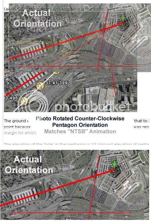
Rob, you're wrong. The photo on your site has the Pentagon rotated about 10 degrees counter-clockwise from what it shows it to be on Google maps.
I'm not sure how you can even begin to deny this. Look at the west face of the Pentagon in your photo. It points at an angle left of a vertical north-south line. The bottom photo shows the same west-wall pointing *right* of the n-s vertical line.
Take a few minutes to digest what I'm talking about here.
Well nick, you do try too hard sometimes, and I'm not sure I follow as to whether or not this graphic is misleading, but...
So the photo was rotated - not just the building but the whole photo, right?
The only way this is deceptive is if the Nav points pinned on were then placed AS IF up was north. If they are mapped in accurate to north on that map, then we just have a case of an accurate charting just turned a bit, for graphics reasons perhaps.
Is there informational miseladig going on here or just rotation?
Please clarify...
Originally posted by nick7261
Originally posted by scrapple
Yes - but in your twist scenario the forgers (who may be cohorts with a quasi-professional pilots group) twists the terrain “opposite” of their sacred “TRUE VIRGINS MAKE DULL COMPANIONS and East is Least, West is Best” rule?
This seems an unlikely scenario to me.
.... If the goal was to show FL 77 coming in visually north of the Citgo then it doesn't matter what the rules are, does it?
I disagree. This is a black box recreation. The animation is a record of actual flight - physical rules apply. Even if data was tampered with the TVMDC must still prevail.
As it stands the compass reads 70*. In the REAL WORLD this "reading" requires a visual shift of the pilot's view to the right ~10*. (or relative to a clockwise turn of the pentagon around its center as the plane stays still).
Why would they accept, not catch , or push a fundamental error to the rules of navigation leaving the animation as is? And why didnt they while tampering alter the displayed compass to ~90*mag to match the North visual?
(again if it comes to light that it was citizens who altered data I will eat my words!)
Originally posted by scrapple
Originally posted by nick7261
.... If the goal was to show FL 77 coming in visually north of the Citgo then it doesn't matter what the rules are, does it?
I disagree. This is a black box recreation. The animation is a record of actual flight - physical rules apply. Even if data was tampered with the TVMDC must still prevail.
Now where did you get that idea, Scrap? That's an actual question, not rhetorical. The data is altered as JDX explains, in part anyway, or however exactly he put it. Including the animation, it's 'not proof of anuthing real' to paraphrase. Part of what got me in trouble here is believing that's what the Pilots meant to imply, but it's the impression you seem to have...
Why would they accept, not catch , or push a fundamental error to the rules of navigation leaving the animation as is? And why didnt they while tampering alter the displayed compass to ~90*mag to match the North visual?
I also thought the Pilots had said this animation matches the FDR. One of the more common things known about the FDR is it's final bearing - 70. So IF you wanted to fake people out like this is what the FDR shows, you'd use the number 70 and a different picture.
Otherwise, I dunno.
Maybe it was just an errored NTSB map rotation after all.
If so they've sure gotten us to waste a lot of time.
new topics
-
God's Righteousness is Greater than Our Wrath
Religion, Faith, And Theology: 1 hours ago -
Electrical tricks for saving money
Education and Media: 4 hours ago -
VP's Secret Service agent brawls with other agents at Andrews
Mainstream News: 5 hours ago -
Sunak spinning the sickness figures
Other Current Events: 6 hours ago -
Nearly 70% Of Americans Want Talks To End War In Ukraine
Political Issues: 6 hours ago -
Late Night with the Devil - a really good unusual modern horror film.
Movies: 8 hours ago -
Cats Used as Live Bait to Train Ferocious Pitbulls in Illegal NYC Dogfighting
Social Issues and Civil Unrest: 9 hours ago -
The Good News According to Jesus - Episode 1
Religion, Faith, And Theology: 11 hours ago
top topics
-
Florida man's trip overseas ends in shock over $143,000 T-Mobile phone bill
Social Issues and Civil Unrest: 16 hours ago, 8 flags -
Cats Used as Live Bait to Train Ferocious Pitbulls in Illegal NYC Dogfighting
Social Issues and Civil Unrest: 9 hours ago, 8 flags -
VP's Secret Service agent brawls with other agents at Andrews
Mainstream News: 5 hours ago, 8 flags -
Bobiverse
Fantasy & Science Fiction: 16 hours ago, 3 flags -
HORRIBLE !! Russian Soldier Drinking Own Urine To Survive In Battle
World War Three: 13 hours ago, 3 flags -
Electrical tricks for saving money
Education and Media: 4 hours ago, 3 flags -
Nearly 70% Of Americans Want Talks To End War In Ukraine
Political Issues: 6 hours ago, 3 flags -
Sunak spinning the sickness figures
Other Current Events: 6 hours ago, 3 flags -
Late Night with the Devil - a really good unusual modern horror film.
Movies: 8 hours ago, 2 flags -
The Good News According to Jesus - Episode 1
Religion, Faith, And Theology: 11 hours ago, 1 flags
active topics
-
VP's Secret Service agent brawls with other agents at Andrews
Mainstream News • 35 • : SchrodingersRat -
The Acronym Game .. Pt.3
General Chit Chat • 7744 • : bally001 -
Truth Social goes public, be careful not to lose your money
Mainstream News • 128 • : Astyanax -
New whistleblower Jason Sands speaks on Twitter Spaces last night.
Aliens and UFOs • 53 • : pianopraze -
Sunak spinning the sickness figures
Other Current Events • 5 • : glen200376 -
SETI chief says US has no evidence for alien technology. 'And we never have'
Aliens and UFOs • 44 • : MikeDeGrasseTyson -
HORRIBLE !! Russian Soldier Drinking Own Urine To Survive In Battle
World War Three • 31 • : budzprime69 -
How ageing is" immune deficiency"
Medical Issues & Conspiracies • 33 • : rickymouse -
The Reality of the Laser
Military Projects • 46 • : Zaphod58 -
God's Righteousness is Greater than Our Wrath
Religion, Faith, And Theology • 0 • : randomuser2034