It looks like you're using an Ad Blocker.
Please white-list or disable AboveTopSecret.com in your ad-blocking tool.
Thank you.
Some features of ATS will be disabled while you continue to use an ad-blocker.

Surviving evidence of the Caribbean disaster
page: 1share:
There are two images that have been presented in speculative studies on Atlantis and the pyramids of the world. These two images are clearly
identified as Mesoamerican art. The question of the matter is, are they original works of the Native people of Central America? They do seem to back
up the legends reported by Montezuma, the Aztec ruler, when Cortez arrived from Spain. Montezuma informed Cortez that his people migrated to
Tenochtitlan (now modern day Mexico City) from their original home land called Aztlan, somewhere in the east. When they were wandering to find their
new home they called themselves the Chichimec, which means savage or nomadic. However, they named their original ancestors as
Toltec which means civilized. There's more to discover about the legends reported by Montezuma.
Here's the first image, which many have already been seen before.
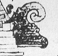
This photo was taken by Teobert Maler (1842-1917) from an unknown spot deep in the jungles of the Yucatan. Author Robert B. Stacy-Judd, who produced “Atlantis-Mother of Empires (1939) holds the original photo in his possession. Robert Stacy-Judd says that before Teobert’s death he said that the stone-frieze was just a portion of a continuous frieze which surrounded the interior of an underground chamber.
No one has ever discovered the underground ruins that Teobert Maler found.
Anyone ready for an expedition?
The pyramid in the frieze matches the design of the Castillo pyramid located at Chichen Itza.

The Mesoamerican warrior in the boat resembles the Toltec worriors of Tula.
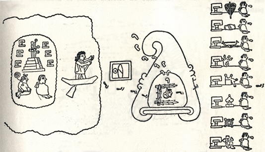
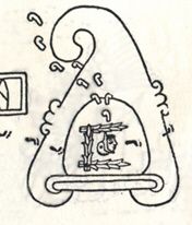
The second evidence of the Caribbean disaster is this painting:
Author, Peter Tompkins displayed this photo in his work entitled, “Mysteries of the Mexican pyramids.” Peter Tompkins didn’t directly identify the source of the painting in the section where he displayed it, so it’s hard to research the original source. There is a bibliography at the end of the book, but it’s in alphabetical order. The painting is very interesting because the warriors are oblivious to the monster tsunamis crashing into the temples.
The tsunami has the features of the bent mountain image illustrated from the Aztec codex in the Boturini
collection. Notice that the stone frieze mentioned earlier shows tsunamis being formed.
www.freewebs.com...
It is believed that Aztlan may be represented by the island with the seven temples.
Some may consider these pictures as representations of the Biblical flood of Noah’s day, but I doubt that’s the case. This looks like an isolated disaster, that is particular to Central America.
Here’s some Mayan temples that might resemble the one in the painting:

This is the Temple of the Sun at Palenque.

This is Temple II at Tikal.
There’s more evidence to be described, such as Conch shells and ADC...
Here's the first image, which many have already been seen before.
This photo was taken by Teobert Maler (1842-1917) from an unknown spot deep in the jungles of the Yucatan. Author Robert B. Stacy-Judd, who produced “Atlantis-Mother of Empires (1939) holds the original photo in his possession. Robert Stacy-Judd says that before Teobert’s death he said that the stone-frieze was just a portion of a continuous frieze which surrounded the interior of an underground chamber.
No one has ever discovered the underground ruins that Teobert Maler found.
Anyone ready for an expedition?
The pyramid in the frieze matches the design of the Castillo pyramid located at Chichen Itza.
The Mesoamerican warrior in the boat resembles the Toltec worriors of Tula.
The second evidence of the Caribbean disaster is this painting:
Author, Peter Tompkins displayed this photo in his work entitled, “Mysteries of the Mexican pyramids.” Peter Tompkins didn’t directly identify the source of the painting in the section where he displayed it, so it’s hard to research the original source. There is a bibliography at the end of the book, but it’s in alphabetical order. The painting is very interesting because the warriors are oblivious to the monster tsunamis crashing into the temples.
The tsunami has the features of the bent mountain image illustrated from the Aztec codex in the Boturini
collection. Notice that the stone frieze mentioned earlier shows tsunamis being formed.
www.freewebs.com...
It is believed that Aztlan may be represented by the island with the seven temples.
Some may consider these pictures as representations of the Biblical flood of Noah’s day, but I doubt that’s the case. This looks like an isolated disaster, that is particular to Central America.
Here’s some Mayan temples that might resemble the one in the painting:
This is the Temple of the Sun at Palenque.
This is Temple II at Tikal.
There’s more evidence to be described, such as Conch shells and ADC...
boy you need to take a course in mesoamerican art
that is not a temple in the first picture
it is a volcano
the rest of your conclusions are just as bad
ask byrd to help you with this
shes quite an expert
that is not a temple in the first picture
it is a volcano
the rest of your conclusions are just as bad
ask byrd to help you with this
shes quite an expert
That's right Marduk,
Also...
...check next to the volcano (left as you see it), its a pyramid crubmling
That's what Lostinspace is getting up
Edit: vocabulary correction
[edit on 24-2-2007 by Dragonlike]
Also...
...check next to the volcano (left as you see it), its a pyramid crubmling
That's what Lostinspace is getting up
Edit: vocabulary correction
[edit on 24-2-2007 by Dragonlike]
Granted, a volcano is pictured, but is that not a collapsing temple in the left side background?
Seeing the rest of the frieze would be very interesting.
Lostinspace, your name disappears into your avatar.
I couldn't see it until it came up in the reply post section.
Good start to what appears to be an interesting discussion.
You have voted lostinspace for the Way Above Top Secret award. You have one more vote left for this month.
well in that case it'd be easy to find the temple wouldn't it
Lost inspace says it matches the design of el castillo
which was built around 600CE
the boat that the character is using also isn't mesoamerican
they used boats made from reeds
looks more like a coracle
and seeing as the first picture is completely unsupported
you can't really base any theories on it
and the designs of temples all vary according to the period
there is no other temple like el castillo anywhere in the americas
and it hasn't collapsed
that was just the civilisation that built it
Originally posted by Marduk there is no other temple like el castillo anywhere in the americas
and it hasn't collapsed
It's becouse parts of Yakatan have been sunked
s8int.com...
The collapse of that island happened by the eruption of a volcano. According to the scientist’s theory, 15,000 years ago the Yucatan peninsula and Cuba were united by a land bridge in the form of a mountain range. Paulina Zelitsky and her collaborators discovered that this same mountain range still exists now, but under the sea.
Does it sounds similar with the picture of Lostinspace above?
*I wonder what Marduk ascribe me this time*
Paulina Zelitsky
don't get me started
side scan sonar isn't that reliable
and we already proved that nothing in cuba sunk in that time frame in another thread
thats just more nonsense from the cuba is atlantis brigade
First, a volcano exists:
Santamaria
Second, a newly (active) volcano has been created in 1939.
Kick-Em-Jenny
As we can see the the Caribbean Plate is thought to be a large igneous province that formed in the Pacific Ocean tens of millions of years ago. As the Atlantic ocean widened, North America and South America were pushed westward, and the Pacific Ocean floor began to subduct under the western edges of the American continents.
But
The Caribbean Plate is thicker and lay higher than the rest of the Pacific Ocean floor, and instead overrode the Atlantic Ocean floor, moving eastward relative to North America and South America, and, with the formation of the Isthmus of Panama 2–3 million years ago, ultimately losing its connection to the Pacific. (That's what created the Kick-em-Jenny)
Caribbean plate
Let's sum up:
The volcano we see in Lostinspace's picture is a volcano created when the Caribbean plate headed westwards and collide with the Pacific one. At that time, the Yukatan as we know it didn't exist but was a piece of land today is submerged at the caribbean. That's volcano is today santamaria. When their plate submerged they headed westwards in the land newly created and started building their new world... That's the boat going to the reef we see...
Today we see the Caribbean plate heading eastward and that's what created the submerged volcano.
I am expecting an ultimate debunking from Marduk, but this time i tried to stick with science and abandon my imagination...
[edit on 24-2-2007 by Dragonlike]
[edit on 24-2-2007 by Dragonlike]
Santamaria
Eruptions at Santamaría are estimated to have begun about 30,000 years ago. For several thousand years, eruptions seem to have been small and frequent, building up the large cone of the volcano, reaching about 1,400 m above the plain on which the nearby city of Quetzaltenango sits
Second, a newly (active) volcano has been created in 1939.
Kick-Em-Jenny
Kick-'em-Jenny is an active submarine volcano on the Caribbean sea floor 8 km north of the island of Grenada and about 8 km west of Ronde Island in the Grenadines at Latitude: 12.300°N. Longitude: 61.640°W. Kick-'em-Jenny rises 1,300 meters (4,300 feet) above the sea floor on the steep inner western slope of the Lesser Antilles ridge. The North American tectonic plate is subducting the Caribbean tectonic plate to the east of this ridge and under the Lesser Antilles island arc.
As we can see the the Caribbean Plate is thought to be a large igneous province that formed in the Pacific Ocean tens of millions of years ago. As the Atlantic ocean widened, North America and South America were pushed westward, and the Pacific Ocean floor began to subduct under the western edges of the American continents.
But
The Caribbean Plate is thicker and lay higher than the rest of the Pacific Ocean floor, and instead overrode the Atlantic Ocean floor, moving eastward relative to North America and South America, and, with the formation of the Isthmus of Panama 2–3 million years ago, ultimately losing its connection to the Pacific. (That's what created the Kick-em-Jenny)
The eastern boundary is a subduction zone, but since the boundary between the North and South American Plates in the Atlantic is as yet undefined, it is unclear which one, or possibly both, is descending under the Caribbean Plate. Subduction forms the volcanic islands of the Lesser Antilles island arc from the Virgin Islands in the north to the islands off the coast of Venezuela in the south. This boundary contains seventeen active volcanoes, most notably Soufriere Hills on Montserrat, Mount Pelée on Martinique, La Grande Soufrière on Guadeloupe, Soufrière Saint Vincent on Saint Vincent, and the submarine volcano Kick-'em-Jenny which lies about 10 km north of Grenada.
Caribbean plate
Let's sum up:
The volcano we see in Lostinspace's picture is a volcano created when the Caribbean plate headed westwards and collide with the Pacific one. At that time, the Yukatan as we know it didn't exist but was a piece of land today is submerged at the caribbean. That's volcano is today santamaria. When their plate submerged they headed westwards in the land newly created and started building their new world... That's the boat going to the reef we see...
Today we see the Caribbean plate heading eastward and that's what created the submerged volcano.
I am expecting an ultimate debunking from Marduk, but this time i tried to stick with science and abandon my imagination...
[edit on 24-2-2007 by Dragonlike]
[edit on 24-2-2007 by Dragonlike]
so what youre saying is
that a volcano is Guatemala is somehow relevant to a site in Mexico
two questions i need you to answer Dragonlike
1) do you know where Mexico is
2) do you know where Guatemala is
if thats first I can't wait to see what you come up with for second
[edit on 24-2-2007 by Marduk]
that a volcano is Guatemala is somehow relevant to a site in Mexico
two questions i need you to answer Dragonlike
1) do you know where Mexico is
2) do you know where Guatemala is
First, a volcano exists:
if thats first I can't wait to see what you come up with for second
[edit on 24-2-2007 by Marduk]
This comment made by you (Marduk) proves one thing, that you did not care for the subject matter. Your immediate reaction was to post that I was in
error and gullible to believe such a thing. You need to think before you pass judgement.
I was really hoping that the skeptics would give a break down of the images. The problem with the boat style was a good comment.
What makes the images seem legit or hoax?
The image of the erupting mountain was published in a book in 1939, so its not photo-shopped. The only way it could be a hoax is if someone carved it out of stone in the modern era. Well, it's a fine piece of art if someone did it in 19th century to try to push their belief.
I want to hear analysis on the different aspects of the stone-frieze. What's the flying object near the volcano? What is causing the large downward wave in the far right of the image? Do you notice the finger of another drowning individual in the far left?
I can't believe no one commented on the paiting of the four warriors. I've seen Kung Fu warriors have the same hair piece as the warriors in the painting. The painting has a style similar to the works in the Boturini collection. They both have the same "J" patterns going in various directions. They both have the same pyramid style at the base. Why the difference in the top portions of the temples? I did notice that the painting with the tsunami had more realistic human characters, compared to the ones in the Boturini collection. The humans in the Boturini collection look cartoonish.
Please try to prove that these are Hoaxes.
[edit on 24-2-2007 by lostinspace]
[edit on 24-2-2007 by lostinspace]
What came first?
The chicken or the egg?
Take note of the three ripples in both pictures.
Both these images have to represent the same thing.
files.abovetopsecret.com...
www.freewebs.com...
Is it a tsunami or a crooked mountian?
Mountains don't curl or crest, as waves do.
[edit on 25-2-2007 by lostinspace]
The chicken or the egg?
Take note of the three ripples in both pictures.
Both these images have to represent the same thing.
files.abovetopsecret.com...
www.freewebs.com...
Is it a tsunami or a crooked mountian?
Mountains don't curl or crest, as waves do.
[edit on 25-2-2007 by lostinspace]
Take note of the three ripples in both pictures. They have to represent the same thing.
From what i see,
In the first one: the surge is heading left-wards
and
in the second one: the surge is heading right-wards
Did Maya design the wave in reverse?
[edit on 25-2-2007 by Dragonlike]
Usually when waves or tsunamis approach a coast they will crest toward the land. The coast could have been on the left side of the Mayan temple and
the tsunami crested after it hit.
Check out this movie clip from Youtube.com
www.youtube.com...
This is a combination of movies involving a meteor impact to earth.
The fist 1:48 minutes is from the movie Armageddon. The final portion is from the movie Deep Impact. The portion that relates to this topic starts at 3:24. This is how CG engineers feel how a giant tsunami would travel.
The clip is quite moving.
[edit on 25-2-2007 by lostinspace]
Tsunamis don't curl. They're not a "wave", but are instead just a surge of water. Look at some footage of teh tsunami that hit Indonedia in 2005.
There is no crest, it's just like the ocean rose several feet and surged inland.
A tsunami, basicly, is an oceanic flood.
A tsunami, basicly, is an oceanic flood.
Uhm... WHAT Caribbean disaster??
Marduk called it into question, so I started looking at Mesoamerican art.
He's right. That's not art done by any Mayan, Olmec, or Aztec (or Incan for that matter.) The clothing is wrong, the facial styles are wrong, and the boat is wrong. So is the hair of the woman in the water.
So it's a modern piece, done by someone who is imitating the artform. It shouldn't be used as evidence of anything.
Furthermore, TRUE Mesoamerican art was always accompanied by hieroglyphics that explained the picture. If the image you are presented doesn't show (and translate) the accompanying hieroglyphic text, then you can suspect you're not being shown the whole thing.
Anybody got any details where he was supposed to have been?
The frieze pyramid is falling down. I don't see how you made that determination. And since it's a modern piece, they could have made it look like the Emperor's Palace in Beijing if they liked.
Take a closer look at the images you provided... REALLY look at them.
See the difference in the fake's "earrings" and the real thing? Look at the fake's head... the feathers that are more similar to Plains tribe Indians (suggesting that the fake was actually someone in North America and not in the area of Mexico) rather than the crownlike arrangements of the Toltecs or long elaborate headdresses of the other people fo that area.
Now... there are two more clues that says this was created by a Caucasian from North America: The first is that there's a "blackface circle" around the lips. This is a stylized racial slur used ONLy by Caucasian in the US and dates to the time of the minstrel shows:
en.wikipedia.org...
No real Mesoamerican art ever designated themselves with "blackface".
Next is the particularly idiotic use of the "bone in the nose" for decoration. Again, this is a stylized racial slur used ONLY by Caucasians in the US in the early 1900's and symbolizes that the people are "savages."
So, it's a fake, and actually a very offensive racial slur of a fake.
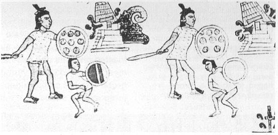
It's from the Codex Mendoza.
www.ancientscripts.com...
Remember how I keep saying that information published without the accompanying text is unreliable? The Codex Mendoza has, in Spanish and in Aztec, a description of what that scene is. It depicts the Aztec conquest of two cities, Colhuacan and Tenayucan.
That's because the "wave" is the logogram ("word") for Colhuacan. The other is the word for Tenayucan.
Originally posted by lostinspace
These two images are clearly identified as Mesoamerican art. The question of the matter is, are they original works of the Native people of Central America?
Marduk called it into question, so I started looking at Mesoamerican art.
He's right. That's not art done by any Mayan, Olmec, or Aztec (or Incan for that matter.) The clothing is wrong, the facial styles are wrong, and the boat is wrong. So is the hair of the woman in the water.
So it's a modern piece, done by someone who is imitating the artform. It shouldn't be used as evidence of anything.
Furthermore, TRUE Mesoamerican art was always accompanied by hieroglyphics that explained the picture. If the image you are presented doesn't show (and translate) the accompanying hieroglyphic text, then you can suspect you're not being shown the whole thing.
No one has ever discovered the underground ruins that Teobert Maler found.
Anyone ready for an expedition?
Anybody got any details where he was supposed to have been?
The pyramid in the frieze matches the design of the Castillo pyramid located at Chichen Itza.
The frieze pyramid is falling down. I don't see how you made that determination. And since it's a modern piece, they could have made it look like the Emperor's Palace in Beijing if they liked.
The Mesoamerican warrior in the boat resembles the Toltec worriors of Tula.
Take a closer look at the images you provided... REALLY look at them.
See the difference in the fake's "earrings" and the real thing? Look at the fake's head... the feathers that are more similar to Plains tribe Indians (suggesting that the fake was actually someone in North America and not in the area of Mexico) rather than the crownlike arrangements of the Toltecs or long elaborate headdresses of the other people fo that area.
Now... there are two more clues that says this was created by a Caucasian from North America: The first is that there's a "blackface circle" around the lips. This is a stylized racial slur used ONLy by Caucasian in the US and dates to the time of the minstrel shows:
en.wikipedia.org...
No real Mesoamerican art ever designated themselves with "blackface".
Next is the particularly idiotic use of the "bone in the nose" for decoration. Again, this is a stylized racial slur used ONLY by Caucasians in the US in the early 1900's and symbolizes that the people are "savages."
So, it's a fake, and actually a very offensive racial slur of a fake.
Author, Peter Tompkins displayed this photo in his work entitled, “Mysteries of the Mexican pyramids.” Peter Tompkins didn’t directly identify the source of the painting in the section where he displayed it, so it’s hard to research the original source.
It's from the Codex Mendoza.
www.ancientscripts.com...
Remember how I keep saying that information published without the accompanying text is unreliable? The Codex Mendoza has, in Spanish and in Aztec, a description of what that scene is. It depicts the Aztec conquest of two cities, Colhuacan and Tenayucan.
The painting is very interesting because the warriors are oblivious to the monster tsunamis crashing into the temples.
That's because the "wave" is the logogram ("word") for Colhuacan. The other is the word for Tenayucan.
Anybody got any details where he was supposed to have been?
He settled in Yucatán with small house in the town of Ticul, where he set up a photographic studio and learned the Maya language. However he spent most of his time in the forests, accompanied by a few Maya to help clear the jungle from the ruins and carry Maler's photographic equipment. He started off visiting major sites already well-known, such as Chichen Itza and Uxmal, but zealously followed all leads and became the first to document many new ruins. At Chichen, he lived in the ruins for 3 months, and documented the site much more fully than had earlier visitors.
Over the next years Maler also made investigations of many remote sites in the el Petén region of Guatemala and along the course of the Usumacinta River.
en.wikipedia.org...
the only ruins known to be in that area are those of Tikal
en.wikipedia.org...
its been pretty well documented and that picture has never been seen since Maler claimed to have taken a picture of it
so
its undocumented
and like you already said Byrd
not very realistic
i'd bet money that lostinspace won't accept that though
he thinks hes found Atlantis or something
and anyway, if this is supposed to be a picture taken of a wall mural
why is there a black background beneath it
looks like someone layed a very flat carving down on a black cloth to photograph it
and Mayan murals were carved into the square blocks that made up the building they were contained in
so its pretty suspect anyway you want to look at it
once again though this is what the fifth time now that lostinspace has posted this image
each time he does the claims get more and more bizarre
[edit on 25-2-2007 by Marduk]
Originally posted by lostinspace
Take note of the three ripples in both pictures.
Both these images have to represent the same thing.
You can probably find one-hundred pictures with three ripples, it does not make something proof.
If I find two pictures of people travelling to the moon in a balloon, does it mean they did?
Thank's for providing the link to the Mendoza Codex, Byrd, and for giving the constructive feedback on the stone-frieze.
I'll drop the issue when there's no doubt left.
With the issue with the head-dress of the Tollan warrior, I just assumed all the rest of the feathers fell out when he was running to the boat.
I'll drop the issue when there's no doubt left.
With the issue with the head-dress of the Tollan warrior, I just assumed all the rest of the feathers fell out when he was running to the boat.
It's quite funny that a crooked mountain, also known as "Colhuacan", next to a toppled temple means to be conquered. Both "Can" and "Tepec"
have a mouth to eat their victims.
Still, seeing it as a "crooked mountian" with such a fluid curve does not make any sense. It sounds more reasonable that Colhuacan is a wave that eats its victims and knocks down the temple tops.
It looks like Colhuacan at rest is Tepec.
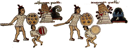

www.ancientscripts.com...
Still, seeing it as a "crooked mountian" with such a fluid curve does not make any sense. It sounds more reasonable that Colhuacan is a wave that eats its victims and knocks down the temple tops.
It looks like Colhuacan at rest is Tepec.
www.ancientscripts.com...
new topics
-
Las Vegas UFO Spotting Teen Traumatized by Demon Creature in Backyard
Aliens and UFOs: 25 minutes ago -
2024 Pigeon Forge Rod Run - On the Strip (Video made for you)
Automotive Discussion: 1 hours ago -
Gaza Terrorists Attack US Humanitarian Pier During Construction
Middle East Issues: 1 hours ago -
The functionality of boldening and italics is clunky and no post char limit warning?
ATS Freshman's Forum: 2 hours ago -
Meadows, Giuliani Among 11 Indicted in Arizona in Latest 2020 Election Subversion Case
Mainstream News: 3 hours ago -
Massachusetts Drag Queen Leads Young Kids in Free Palestine Chant
Social Issues and Civil Unrest: 3 hours ago -
Weinstein's conviction overturned
Mainstream News: 4 hours ago -
Supreme Court Oral Arguments 4.25.2024 - Are PRESIDENTS IMMUNE From Later Being Prosecuted.
Above Politics: 6 hours ago -
Krystalnacht on today's most elite Universities?
Social Issues and Civil Unrest: 6 hours ago -
Chris Christie Wishes Death Upon Trump and Ramaswamy
Politicians & People: 7 hours ago
top topics
-
Krystalnacht on today's most elite Universities?
Social Issues and Civil Unrest: 6 hours ago, 8 flags -
Weinstein's conviction overturned
Mainstream News: 4 hours ago, 6 flags -
University of Texas Instantly Shuts Down Anti Israel Protests
Education and Media: 9 hours ago, 6 flags -
Supreme Court Oral Arguments 4.25.2024 - Are PRESIDENTS IMMUNE From Later Being Prosecuted.
Above Politics: 6 hours ago, 5 flags -
Massachusetts Drag Queen Leads Young Kids in Free Palestine Chant
Social Issues and Civil Unrest: 3 hours ago, 4 flags -
Meadows, Giuliani Among 11 Indicted in Arizona in Latest 2020 Election Subversion Case
Mainstream News: 3 hours ago, 4 flags -
Chris Christie Wishes Death Upon Trump and Ramaswamy
Politicians & People: 7 hours ago, 2 flags -
Any one suspicious of fever promotions events, major investor Goldman Sachs card only.
The Gray Area: 11 hours ago, 2 flags -
Gaza Terrorists Attack US Humanitarian Pier During Construction
Middle East Issues: 1 hours ago, 2 flags -
2024 Pigeon Forge Rod Run - On the Strip (Video made for you)
Automotive Discussion: 1 hours ago, 1 flags
active topics
-
Las Vegas UFO Spotting Teen Traumatized by Demon Creature in Backyard
Aliens and UFOs • 2 • : Ophiuchus1 -
Candidate TRUMP Now Has Crazy Judge JUAN MERCHAN After Him - The Stormy Daniels Hush-Money Case.
Political Conspiracies • 783 • : Threadbarer -
Gaza Terrorists Attack US Humanitarian Pier During Construction
Middle East Issues • 19 • : Consvoli -
Sunak spinning the sickness figures
Other Current Events • 21 • : Xtrozero -
Nearly 70% Of Americans Want Talks To End War In Ukraine
Political Issues • 87 • : Xtrozero -
University of Texas Instantly Shuts Down Anti Israel Protests
Education and Media • 187 • : Irishhaf -
God's Righteousness is Greater than Our Wrath
Religion, Faith, And Theology • 30 • : confuzedcitizen -
Chris Christie Wishes Death Upon Trump and Ramaswamy
Politicians & People • 19 • : DontTreadOnMe -
Supreme Court Oral Arguments 4.25.2024 - Are PRESIDENTS IMMUNE From Later Being Prosecuted.
Above Politics • 60 • : Annee -
Breaking Baltimore, ship brings down bridge, mass casualties
Other Current Events • 489 • : Threadbarer