It looks like you're using an Ad Blocker.
Please white-list or disable AboveTopSecret.com in your ad-blocking tool.
Thank you.
Some features of ATS will be disabled while you continue to use an ad-blocker.

Hurricane Otis Heads Towards Arizona
page: 2share:
Hurricane Otis continues to strengthen.
MOVEMENT TOWARD...NORTHWEST NEAR 7 MPH.
MAXIMUM SUSTAINED WINDS... 85 MPH. MINIMUM CENTRAL PRESSURE... 980 MB.
RAINFALL TOTALS OF 3 TO 5 INCHES WILL BE POSSIBLE OVER PORTIONS OF
SOUTHERN BAJA CALIFORNIA TODAY THROUGH SATURDAY... AND SPREADING
NORTHWARD INTO CENTRAL BAJA CALIFORNIA TOMORROW. NHC
Hmmm, sounds like they underated the intensity forecast again....seems to be a pattern of that. Maybe the models need reconfigured.
Could a lot of weight on the pacific plate, caused by rain, trigger an earthquake in Southern California?
Looks as if there will be much needed rain in this part of the U.S. next week. I just hope the flash flooding does not happen.
ACCU WEATHER
Hi All,
I saw that Otis had developed into a cat 1. I was abit surprised because I didnt expect that. The I saw the water temp map on the previous page, and it made sense to me then. Regenmacher, thanks for posting the info about caliche in the soil. I had never heard about this before.
Harry55, nice change in avatar. Its from Eye Of The Behloder, right?
Originally posted by PizzaCrust
Could a lot of weight on the pacific plate, caused by rain, trigger an earthquake in Southern California?
The most likely effect from heavy rains is usually mud and landslides which would cause minor termors in Southern Califronia. Socal won't see much if any moisture from Otis.
Swiss floods trigger more earth tremors 25 August, 2005
NZ hit by floods and earthquakes 19 July, 2004
Originally posted by Regenmacher
“que sera, sera..." "Whenever we get there, señor."
Throw in some machismo too, and they rather fight than run.
They'll know when they get there, ya don't fight Mother Nature!
But yes, cardboard shacks do blow away and there's always a zinc sale when it's done.
Zinc
Rolled sheet zinc appeared in the United States in 1816, as roofing in New York and as downspouts and gutters in Baltimore. Though more than seventy houses in New York had zinc roofs by 1837, it was out of favor by 1840. The popularity of the material was cyclical in the next decades, never matching iron and steel with their various coatings.
Fat chance of being asphixiated from generator fumes.
Juan Guzman look on to the Acapulquito beach as hurricane Otis aproaches Friday, Sept. 30, 2005, near San Jose del Cabo, Mexico. Local authorities start evacuating people of the risk zones. (AP Photo/Guillermo Arias)
abcnews.go.com...
[edit on 1-10-2005 by psyopswatcher]
WUNDERGROUND
8 AM PDT UPDATE
Maximum sustained winds are near 100 mph...160 km/hr...with higher
gusts. Otis is a category two hurricane on the Saffir-Simpson scale.
Some fluctuations in strength are possible during the next 24 hours. Estimated minimum central pressure is 979 mb...28.91 inches.
Otis is a Cat 2 Hurricane now. Moving very slow over warm water.
Hello all
Here is a water vapor image from NOAA:
And here is a 2pm update from accuweather.
I wasnt expecting a cat 2 strength increase, I guess because it is expected to hit as a tropical depression. I wonder if this will continue to hold true?
Here is a water vapor image from NOAA:
And here is a 2pm update from accuweather.
Hurricane Otis continues to spin near the southern tip of Baja
California, about 90 miles west-southwest of the southern tip of Baja Mexico. Winds are about 100 mph, with gusts up to 120 mph. The storm will begin to move more to the north, and eventually north-northeast, over the next couple days, weakening as it does so.
I wasnt expecting a cat 2 strength increase, I guess because it is expected to hit as a tropical depression. I wonder if this will continue to hold true?
I lived in Arizona for 4 years and every time around this time of year; it floods. Monsoons move north through Mexico and there's flash flooding
between August and late October.
Does anyone know what their weather has been like in the last few weeks. This will most likely determine how quickly the washes will fill.
Does anyone know what their weather has been like in the last few weeks. This will most likely determine how quickly the washes will fill.
Hi gangster45,
Here is a link I found on weather underground.
Weather History of Tuscan Arizona
If you go there you can change the dates and see what the weather was like for that day. It seems to me that it has been mostly dry and hot for most of last month.
Here is a link I found on weather underground.
Weather History of Tuscan Arizona
If you go there you can change the dates and see what the weather was like for that day. It seems to me that it has been mostly dry and hot for most of last month.
11 AM PDT UPDATE Underground Weather
Maximum sustained winds are near 100 mph...160 km/hr...with higher
gusts. Otis is a category two hurricane on the Saffir-Simpson scale.
Some fluctuations in strength are possible during the next 24 hours.
Estimated minimum central pressure is 979 mb...28.91 inches
Otis is expected to produce total rain accumulations of 3 to 5
inches over the southern Baja Peninsula during the next couple of
days and 4 to 6 inches over the central Baja Peninsula Sunday and
Monday... with possible isolated maximum amounts of 10 inches over
the higher terrain of the central Baja Peninsula. Rainfall
associated with Otis may affect the southwestern U.S. On Tuesday.
This is much needed rain for that section of the U.S. but severe flooding I am afraid.
Originally posted by sylvrshadow
Regenmacher, thanks for posting the info about caliche in the soil. I had never heard about this before.
Here's a little more on where Otis plans to retire:
The Sonoran Desert
Summer storms come up from the Gulf of California and generally last from July - September. They usually occur in the afternoon, are brief, widely scattered, and often extremely heavy with lots of lightning. There is a danger of flash flooding because the top layers of soil become saturated.
Water that collects in low-lying areas quickly becomes alkaline. Thick layers of calcium carbonate form as the lime-enriched groundwater evaporates. These deposits, known as caliche, can grow to be many feet thick and may eventually form an impassable barrier. This increases the likelihood of flash flooding, since rainwater is unable to soak into the ground. Many plants are not able to survive, since they cannot put down deep root systems. source
Sylvrshadow, congrats on 1st place for your Fragile Earth short story too...
Hi All,
Thank you Regenmacher. I was quite surprised that I had won the contest! Thanks also for posting more info on the soil condition in Arizona.(I love it when I learn somethin new!! )
I found a post on Jeff Masters blog about Hurricane Otis. He is pretty much saying the same thing about the flooding issue.
Here is the weather underground IR loop of the eastern pacificThanks to Harry55 for this find. )
Thank you Regenmacher. I was quite surprised that I had won the contest! Thanks also for posting more info on the soil condition in Arizona.(I love it when I learn somethin new!! )
I found a post on Jeff Masters blog about Hurricane Otis. He is pretty much saying the same thing about the flooding issue.
Hurricane Otis threatening Baja and Arizona
Hurricane Otis reached its peak intensity early this morning--a Category 2 hurricane with winds of 105 mph. Otis is now a Category 1 hurricane with 85 mph winds, and is expected to slowly creep northwestward over cooler waters and gradually weaken. By the time it takes a more northerly track and crosses the Baja Peninsula on Monday, Otis will probably be a strong tropical storm or weak Category 1 hurricane. Hurricane force winds extend outwards only 15 miles from Otis's center, so only a small portion of the coast will receive wind damage. Heavy rains of 5 - 10 inches will be the main problems with Otis, potentially triggering serious flash flooding in the desert mountains of Mexico. By Tuesday, portions of southern Arizona may receive 3 - 5 inches of rain, creating flash flooding problems there.
Here is the weather underground IR loop of the eastern pacificThanks to Harry55 for this find. )
Originally posted by gangster45
Does anyone know what their weather has been like in the last few weeks. This will most likely determine how quickly the washes will fill.
It has been dry as a bone last few weeks and the monsoon season abruptly ended as noted earlier in this thread. Tuscon is below normal rainfall and California on fire tells the story.
newweb.wrh.noaa.gov...
A MORE SIGNIFICANT INCREASE IN MOISTURE...EMANATING FROM OTIS...WILL OCCUR SUNDAY NIGHT AND MONDAY. THIS INCREASE IN MOISTURE WILL LEAD TO A CHANCE OF SHOWERS AND THUNDERSTORMS...MAINLY OVER SOUTH-CENTRAL ARIZONA...BEGINNING SUNDAY NIGHT AND DIMINISHING TUESDAY NIGHT. TEMPERATURES WILL BE COOLER MONDAY AND TUESDAY BEFORE WARMING AGAIN DURING THE LATTER HALF OF NEXT WEEK.
iwin.nws.noaa.gov...
Otis has kind of stalled out (3 mph northern motion) and the models are taking a it farther west of Phoenix rather than into Tucson. Not good for the
Baja, since slower forward speed means more flooding. On a positive note, cold water upwelling from stalling may decrease Otis' intensity, and recent
satellite images seem to indicate this is happening.
MAXIMUM SUSTAINED WINDS ARE NEAR 80 MPH...130 KM/HR...WITH HIGHER
GUSTS. SOME GRADUAL WEAKENING IS FORECAST DURING THE NEXT 24
HOURS...BUT OTIS COULD STILL REACH THE BAJA CALIFORNIA PENINSULA
AS A HURRICANE. NHC
OTIS IS EXPECTED TO PRODUCE TOTAL RAIN ACCUMULATIONS OF 3 TO 6
INCHES OVER THE CENTRAL AND SOUTHERN BAJA PENINSULA THROUGH
MONDAY...WITH ISOLATED MAXIMUM AMOUNTS OF 10 INCHES OVER
THE HIGHER TERRAIN OF THE CENTRAL BAJA PENINSULA.
Cars drive through a somel flooding in downtown Cabo San Lucas as hurricane Otis passes 130 miles south west Saturday, Oct. 1 2005, in South California, Mexico.
Juan Carlos Gonzalez, 5, stands near his house at Las Palmas, one of the poorest zones in Cabo San Lucas as hurricane Otis passes 130 miles south west Saturday.
Thanks for the references
Is there any way for the storm to regain strength as it goes over that inlet? I'm not sure what the water's like in that region, I'm sure it's very warm this time of year.
By the looks of things, Arizona will get what it normally gets, lots of lightning with a quick dumping of rain, then it will be over. People of this area are well equipped to handle any type of flash flooding.
We build all our homes on high ground
Originally posted by gangster45
Is there any way for the storm to regain strength as it goes over that inlet? I'm not sure what the water's like in that region, I'm sure it's very warm this time of year.
They usually don't rebuild or strengthen over the Gulf of California, least I have yet to see one and have been following EPAC storms for over 10 years. Considering the ground isn't saturated by any recent storms and monsoonal flow is all but gone, I would say Otis will be sucked dry as he comes inland. The land is thirsty
OTIS IS NOT FARING VERY WELL OFF THE SOUTHERN BAJA COAST. NEVER VERY
LARGE TO BEGIN WITH...OTIS IS BARELY HOLDING ON TO TROPICAL STORM
STRENGTH AND CONTINUES TO WEAKEN AS UPPER LEVEL SHEAR...DRY
AIR...COOLER WATERS AND INTERACTION WITH THE BAJA PENINSULA TAKE
THEIR TOLL. MOVEMENT IS TO THE NORTH AT ABOUT 6KTS. IF THE SAD
TATTERED REMAINS OF THE CORE OF THE STORM DO MAKE IT THIS FAR NORTH
LATER IN THE WEEK...EXPECT NO MORE THAN A WEAK LOW LEVEL SWIRL OF
CLOUDS.
iwin.nws.noaa.gov...
Visible satellite of the day 10-02-05:
THE SHIPS...GFDL...AND THE FSU SUPERENSEMBLE AGREE ON
DISSIPATION IN 48 HOURS...BEFORE REACHING THE CENTRAL BAJA
CALIFORNIA COAST. THE OFFICIAL FORECAST WILL FOLLOW SUIT...HOWEVER
RETAINS THE SYSTEM AS A 20 KT REMNANT LOW MOVING ONSHORE IN 48
HOURS...AND DISSIPATES IT OVER THE PENINSULA IN 96 HOURS.
www.nhc.noaa.gov...
Hope it brings some rain to the southwest, they could really use it.
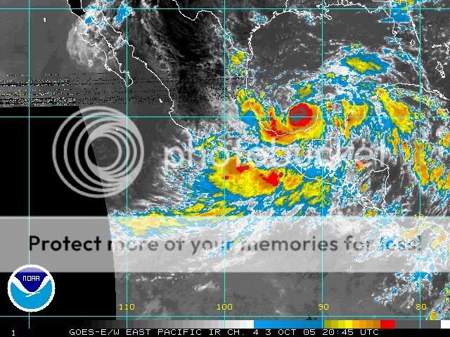
He is looking tattered alright. (upper left corner)
Hey! What's this off Campeche? Something wicked in the GOM?
[edit on 3-10-2005 by psyopswatcher]
Hey! What's this off Campeche? Something wicked in the GOM?
[edit on 3-10-2005 by psyopswatcher]
new topics
-
Meadows, Giuliani Among 11 Indicted in Arizona in Latest 2020 Election Subversion Case
Mainstream News: 7 minutes ago -
Massachusetts Drag Queen Leads Young Kids in Free Palestine Chant
Social Issues and Civil Unrest: 22 minutes ago -
Weinstein's conviction overturned
Mainstream News: 1 hours ago -
Supreme Court Oral Arguments 4.25.2024 - Are PRESIDENTS IMMUNE From Later Being Prosecuted.
Above Politics: 3 hours ago -
Krystalnacht on today's most elite Universities?
Social Issues and Civil Unrest: 3 hours ago -
Chris Christie Wishes Death Upon Trump and Ramaswamy
Politicians & People: 3 hours ago -
University of Texas Instantly Shuts Down Anti Israel Protests
Education and Media: 5 hours ago -
Any one suspicious of fever promotions events, major investor Goldman Sachs card only.
The Gray Area: 8 hours ago
top topics
-
VP's Secret Service agent brawls with other agents at Andrews
Mainstream News: 17 hours ago, 11 flags -
Krystalnacht on today's most elite Universities?
Social Issues and Civil Unrest: 3 hours ago, 7 flags -
Nearly 70% Of Americans Want Talks To End War In Ukraine
Political Issues: 17 hours ago, 6 flags -
Weinstein's conviction overturned
Mainstream News: 1 hours ago, 6 flags -
Sunak spinning the sickness figures
Other Current Events: 17 hours ago, 5 flags -
Electrical tricks for saving money
Education and Media: 15 hours ago, 5 flags -
Supreme Court Oral Arguments 4.25.2024 - Are PRESIDENTS IMMUNE From Later Being Prosecuted.
Above Politics: 3 hours ago, 5 flags -
University of Texas Instantly Shuts Down Anti Israel Protests
Education and Media: 5 hours ago, 3 flags -
Any one suspicious of fever promotions events, major investor Goldman Sachs card only.
The Gray Area: 8 hours ago, 2 flags -
Chris Christie Wishes Death Upon Trump and Ramaswamy
Politicians & People: 3 hours ago, 1 flags
active topics
-
University of Texas Instantly Shuts Down Anti Israel Protests
Education and Media • 121 • : cherokeetroy -
Candidate TRUMP Now Has Crazy Judge JUAN MERCHAN After Him - The Stormy Daniels Hush-Money Case.
Political Conspiracies • 752 • : Vermilion -
VP's Secret Service agent brawls with other agents at Andrews
Mainstream News • 48 • : 5thHead -
-@TH3WH17ERABB17- -Q- ---TIME TO SHOW THE WORLD--- -Part- --44--
Dissecting Disinformation • 673 • : Thoughtful3 -
SETI chief says US has no evidence for alien technology. 'And we never have'
Aliens and UFOs • 66 • : SchrodingersRat -
Weinstein's conviction overturned
Mainstream News • 14 • : Encia22 -
Meadows, Giuliani Among 11 Indicted in Arizona in Latest 2020 Election Subversion Case
Mainstream News • 0 • : IndieA -
Nearly 70% Of Americans Want Talks To End War In Ukraine
Political Issues • 83 • : SchrodingersRat -
Supreme Court Oral Arguments 4.25.2024 - Are PRESIDENTS IMMUNE From Later Being Prosecuted.
Above Politics • 43 • : RazorV66 -
"We're All Hamas" Heard at Columbia University Protests
Social Issues and Civil Unrest • 284 • : 5thHead