It looks like you're using an Ad Blocker.
Please white-list or disable AboveTopSecret.com in your ad-blocking tool.
Thank you.
Some features of ATS will be disabled while you continue to use an ad-blocker.

Map Size vs Actual Size of Countries
page: 1share:
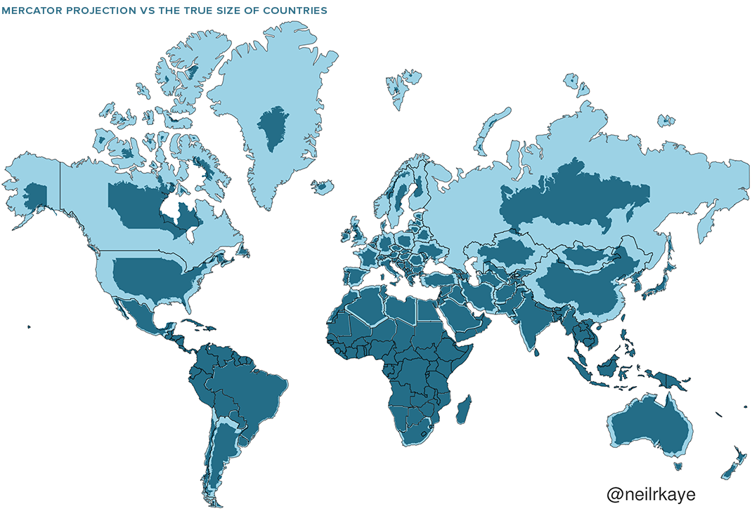
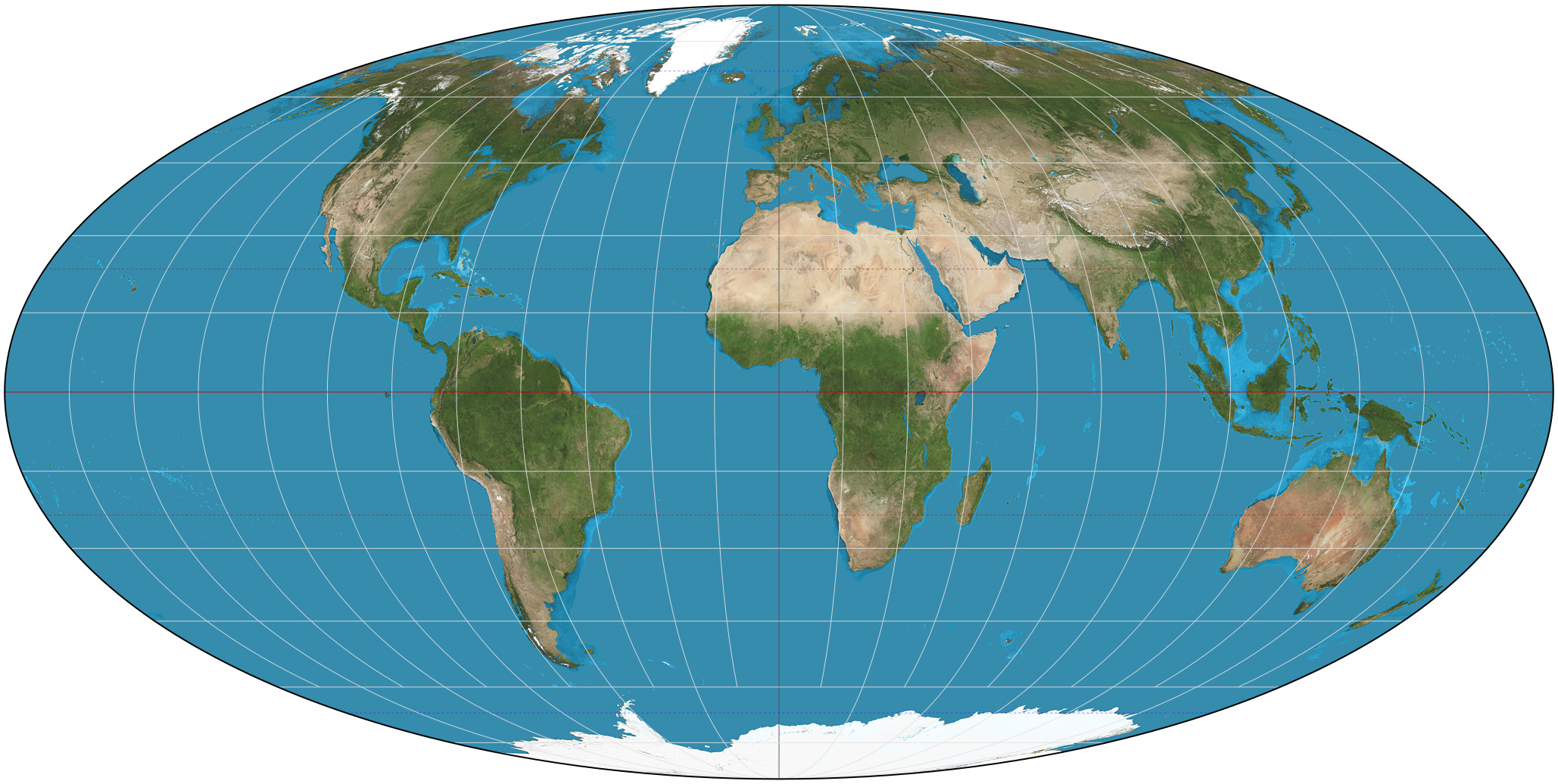
The Mercator projection (/mərˈkeɪtər/) is a cylindrical map projection presented by Flemish geographer and cartographer Gerardus Mercator in 1569. It became the standard map projection for navigation because it is unique in representing north as up and south as down everywhere while preserving local directions and shapes. The map is thereby conformal. As a side effect, the Mercator projection inflates the size of objects away from the equator. This inflation is very small near the equator but accelerates with increasing latitude to become infinite at the poles. As a result, landmasses such as Greenland, Antarctica, Canada and Russia appear far larger than they actually are relative to landmasses near the equator, such as Central Africa.
Some may have already been aware of the traditional use of this centuries old practice in map-making. Cartography presents a problem that had to be figured out in some way -- how do you translate an image from a globe onto a flat map. You can't. If you took a beach ball and wanted to make it flat, stretch it out to a flat surface, you'd have to cut in radially from the top and the bottom, and the cuts would meet in the middle. When you stretch out a globe, just like a beach ball, it ends up creating a map that looks like this:
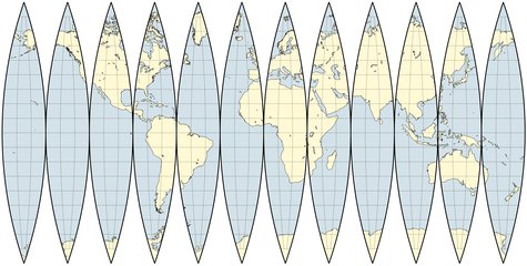
Anything that is near the equator remains pretty much the way it is, but as you move more to the north and to the south, wider and wider gaps appear. You can't make or sell maps looking like that! So what was the solution? Mercator decided to simply fill in the areas in between. And since the 16th century, European, and then global cartographers, continued the practice and we all got used to seeing the world through a distorted projection.
The only way to accurately compare the sizes of the continents and nations are to own a globe. But not everyone owns a globe, and not everyone is aware of the distortions our modern maps create.
The map at the top shows the true size of global geography. For example, take a look at the northernmost landmasses, Canada, Greenland, Scandinavia and Russia. The actual size of those landmasses is represented by the smaller, darker outline within. Greenland is about a 10th size it appears on maps. Canada shrinks to a similar size as the continental US. Scandinavia no longer towers over Europe, and Russia can now fit into Africa twice over, instead of looking like a never-ending behemoth. China becomes the same size as Australia, and Africa remains pretty much the same, a true monster of a continent. Compare Ukraine and Russia, and Ukraine is no longer about the 20th of Russia, but about a 5th. Russia and China are much closer in size then any maps will show.
This gif can also help with the visualization of the differences.
Mercator Projection
Here's a good solution for the northern hemisphere. Let's make one like this for the south?
This map reminds me of when I was nightclubing in the 80's, some guys would wear skin tight jeans with a sock in their pants to appear larger.
Russia and Canada you're not fooling anyone with the sock.
Russia and Canada you're not fooling anyone with the sock.
edit on 26-5-2023 by PureBlood because: Added more
One reason why the world has been content with Mercator is that "knowing the relative sizes of countries" has not been seen as a priority. People have
been more interested in locating countries in relation to each other, for the sake of travel and movements of arnies. For that purpose, Mercator
centred upon the Greenwich meridian is ideal (unless you're fighting a war in the Pacific). It tells you that you reach Greenland by sailing west from
Iceland, and that it's a good jumping-off point for the North pole, and you don't normally need to know much more than that.
Sorta mental when you realise just how huge Africa is....You can fit the USW, China and India in there easily and still have a ton of room left over.
originally posted by: DISRAELI
One reason why the world has been content with Mercator is that "knowing the relative sizes of countries" has not been seen as a priority. People have been more interested in locating countries in relation to each other, for the sake of travel and movements of arnies. For that purpose, Mercator centred upon the Greenwich meridian is ideal (unless you're fighting a war in the Pacific). It tells you that you reach Greenland by sailing west from Iceland, and that it's a good jumping-off point for the North pole, and you don't normally need to know much more than that.
It's an excellent point, I read this thread late last night and began to ponder the ramifications and reasons too, and fell asleep thinking about it. It's amazing how accurate early cartographers and explorers actually were in their depictions.
Definitely true about the movement of early armies, makes me wonder how widespread the knowledge of the maps was this way early on. How many early explorers were thrown off by the enormity of Africa?
Hell, I can spend hours on Google Earth, just the vastness of the Pacific alone, how in the hell did the Polynesians do so much pioneering? Who looked at a map and said let's all go there? and of BTW it's gonna be such a long arduous voyage some of us are likely to die.
Why do some migrate and some still live within 50 miles of thier ancestral homes
LOL Im definitely a landlubber
Hell, we rented a smallish outboard in Fort Lauderdale one time and went off the coast till the coastline got smaller and smaller and it makes you realize if you let that slide over the horizon in the evening, you had better have and know how to use a compass at the very least. A bit disorienting
On a side note, I was about the discuss the chicken theory where Polynesians and Chile supposedly had the same chickens now they are pretty much thinking the exact opposite. So much we still don't know and may never know
www.nationalgeographic.com...
The peopling of the South Pacific happened in two stages, the first of which took place more than 3,000 years ago when mysterious seafarers known as the Lapita set off from Papua New Guinea's Bismarck Archipelago into the great blue void of the Pacific. Within a startlingly few generations they managed to find and colonize hundreds of hidden tropical paradises: Vanuatu, Fiji, Tonga, Samoa, New Caledonia.
They sailed as pioneers, not explorers, bringing their families and everything they might need to build new homes on the lands they clearly expected to find: flints for toolmaking, pottery, and foodstuffs—including their chickens.
A second, much later phase, beginning around the year A.D. 800, saw them expand into the vastness of the eastern Pacific—to Tahiti, Bora Bora, the Marquesas, Easter Island, and Hawaii. Precisely how these people accomplished such astonishing voyages, and why they attempted them, remains an intriguing mystery, for they left behind no writings and very few artifacts. (Read "Beyond the Blue Horizon" in National Geographic magazine.)
With so few clues to work from—not a single example of an early Polynesian voyaging canoe survives today—archaeologists have been forced to tease out the story of this great migration from the evidence of scattered bones and pottery shards on far-flung islands, and strands of DNA from the plants and livestock the South Seas pioneers brought with them and whose descendants live on today.
edit on 27-5-2023 by putnam6 because: (no reason given)
originally posted by: putnam6
Definitely true about the movement of early armies, makes me wonder how widespread the knowledge of the maps was this way early on. How many early explorers were thrown off by the enormity of Africa?
Hell, I can spend hours on Google Earth, just the vastness of the Pacific alone, how in the hell did the Polynesians do so much pioneering? Who looked at a map and said let's all go there? and of BTW it's gonna be such a long arduous voyage some of us are likely to die.
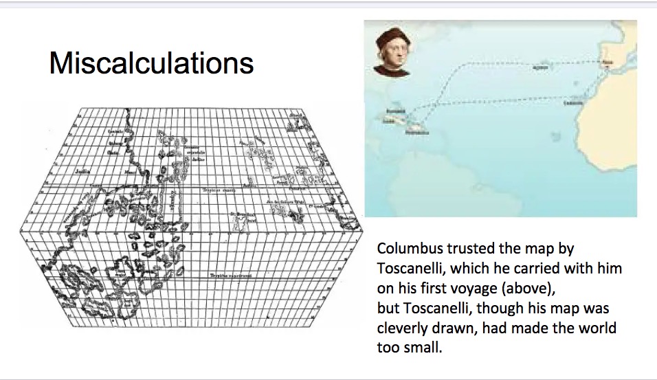
The very earliest explorers had the blissfulness of ignorance. They had no maps, so they did not know that their journey was impossible, so they saw no reason not to try. They thought their destination would be round the next cape, and didn't know otherwise until they looked. Even Columbus tried only because all his calculations were wrong, and he thought the Europe-to-China sea-journey was much shorter than it really was.
edit on
27-5-2023 by DISRAELI because: (no reason given)
originally posted by: DISRAELI
originally posted by: putnam6
Definitely true about the movement of early armies, makes me wonder how widespread the knowledge of the maps was this way early on. How many early explorers were thrown off by the enormity of Africa?
Hell, I can spend hours on Google Earth, just the vastness of the Pacific alone, how in the hell did the Polynesians do so much pioneering? Who looked at a map and said let's all go there? and of BTW it's gonna be such a long arduous voyage some of us are likely to die.
The very earliest explorers had the blissfulness of ignorance. They had no maps, so they did not know that their journey was impossible, so they saw no reason not to try. They thought their destination would be round the next cape, and didn't know otherwise until they looked. Even Columbus tried only because all his calculations were wrong, and he thought the Europe-to-China sea-journey was much shorter than it really was.
Well, thats the thing, it wasn't just ignorance many were flat-out wrong, 4 times and Columbus never found India.
www.academia.edu...
originally posted by: DISRAELI
a reply to: putnam6
The "ignorance" theory is perhaps most applicable to the Portuguese getting round Africa on the sea-route.
Yea, Im definitely ignorant of the Portuguese exploration efforts. Most early exploration efforts really, but just think about the twist of fate that allowed some early indigenous cultures to be discovered and ultimately decimated, while others dodged that outcome. Have been reading the link below, amazing how tenuous the English settlement was in Jamestown, without the emergence of tobacco it might not have even survived to open up for another country or countries to become dominant in North America. Never knew of the Portugal-Brazil sugar plantation connection, and thus is tied to the African slave trade. Ironic how conquest is always based on the dominant commodities at the time.
www.americanyawp.com...
The Portuguese
The Portuguese had been leaders in Atlantic navigation well ahead of Columbus’s voyage. But the incredible wealth flowing from New Spain piqued the rivalry between the two Iberian countries, and accelerated Portuguese colonization efforts. This rivalry created a crisis within the Catholic world as Spain and Portugal squared off in a battle for colonial supremacy. The pope had earlier intervened and divided the New World with the Treaty of Tordesillas in 1494. Land east of the Tordesillas Meridian, an imaginary line dividing South America, would be given to Portugal, whereas land west of the line was reserved for Spanish conquest. In return for the license to conquer, both Portugal and Spain were instructed to treat the natives with Christian compassion and to bring them under the protection of the Church.
Lucrative colonies in Africa and India initially preoccupied Portugal, but by 1530 the Portuguese turned their attention to the land that would become Brazil, driving out French traders and establishing permanent settlements. Gold and silver mines dotted the interior of the colony, but two industries powered early colonial Brazil: sugar and the slave trade. In fact, over the entire history of the Atlantic slave trade, more Africans were enslaved in Brazil than in any other colony in the Atlantic World. Gold mines emerged in greater numbers throughout the eighteenth century but still never rivaled the profitability of sugar or slave trading.
Jesuit missionaries brought Christianity to Brazil, but strong elements of African and Native spirituality mixed with orthodox Catholicism to create a unique religious culture. This culture resulted from the demographics of Brazilian slavery. High mortality rates on sugar plantations required a steady influx of new enslaved laborers, thus perpetuating the cultural connection between Brazil and Africa. The reliance on new imports of enslaved laborers increased the likelihood of resistance, however, and those who escaped slavery managed to create several free settlements, called quilombos. These settlements drew from both enslaved Africans and Natives, and despite frequent attacks, several endured throughout the long history of Brazilian slavery.15
Despite the arrival of these new Europeans, Spain continued to dominate the New World. The wealth flowing from the exploitation of the Aztec and Incan Empires greatly eclipsed the profits of other European nations. But this dominance would not last long. By the end of the sixteenth century, the powerful Spanish Armada would be destroyed, and the English would begin to rule the waves.
originally posted by: SprocketUK
Sorta mental when you realise just how huge Africa is....You can fit the USW, China and India in there easily and still have a ton of room left over.
Yeah, it's insane:
Area size in square miles:
USA - 3,797,000
China - 3,705,000
India - 1,269,000
Russia - 6,602,000
Africa - 11,730,000
Flying down to Brazil one finally realizes just how damn big South America is with just Brazil about the same size as the US.
originally posted by: Mahogany
Area size in square miles:
USA - 3,797,000
China - 3,705,000
India - 1,269,000
Russia - 6,602,000
Africa - 11,730,000
And South America is 6,888,000
Brazil is 3,200,000
Continental US is actually 3,119,000
edit on 27-5-2023 by Xtrozero because: (no reason given)
originally posted by: Xtrozero
originally posted by: Mahogany
Area size in square miles:
USA - 3,797,000
China - 3,705,000
India - 1,269,000
Russia - 6,602,000
Africa - 11,730,000
And South America is 17,840,000
Brazil is 3,200,000
Continental US is actually 3,119,000
South America is 6.888m, and yes 3.797 is US with Alaska and Hawaii.
South America and Russia are about the same size.
edit on 27-5-2023 by Mahogany because: (no reason given)
originally posted by: Xtrozero
originally posted by: Mahogany
South America is 6.888m, and yes 3.797 is US with Alaska and Hawaii.
South America and Russia are about the same size.
Thanks, read the wrong number
NP.
__________________________________________
Answer to another poster, yes Google Earth uses Mercator.
Google Maps use a Spherical Normal (equatorial) variant of the Mercator projection for its map images.
We accept imagery projected using a standard cartographic projection such as Universal Transverse Mercator (UTM), a satellite-based datum such as GRS80, or WGS84; or in Geographic Coordinates (aka "latitude/longitude") with WGS84 datum.
It's an updated version of Mercator, but yes it will still show the wrong sizes.
Interesting. I was going to share a pic of the world from space to compare but I realized none of them look real to me. Are there any authentic
pictures of our world (in public access)?
a reply to: Mahogany
Some projections are closer to the truth in regards to area, but they distort shape.
(click for full size)
As said previously, the only way of having an accurate representation of sizes, shapes and distances is by using a globe, if we want to use a flat map we need to choose the right one for what we want to do.
new topics
-
That which the "news" never talks about; Truth about election fraud
Mainstream News: 1 hours ago -
Biden doesnt want the votes of "Death to America" chanters
US Political Madness: 1 hours ago -
Horizon Post office scandal
Regional Politics: 1 hours ago -
Joe Biden and Donald Trump are both traitors
US Political Madness: 4 hours ago -
I'm new here. Avid conspiracy fan.
Introductions: 4 hours ago -
Denmark's Notre-Dame moment - 17th Century Borsen goes up in Flames
Mainstream News: 5 hours ago
top topics
-
Suspected Iranian agent working for Pentagon while U.S. coordinated defense of Israel
US Political Madness: 13 hours ago, 16 flags -
The Baloney aka BS Detection Kit
Social Issues and Civil Unrest: 13 hours ago, 7 flags -
That which the "news" never talks about; Truth about election fraud
Mainstream News: 1 hours ago, 6 flags -
Denmark's Notre-Dame moment - 17th Century Borsen goes up in Flames
Mainstream News: 5 hours ago, 4 flags -
How does my computer know
Education and Media: 16 hours ago, 3 flags -
I'm new here. Avid conspiracy fan.
Introductions: 4 hours ago, 3 flags -
Joe Biden and Donald Trump are both traitors
US Political Madness: 4 hours ago, 2 flags -
Horizon Post office scandal
Regional Politics: 1 hours ago, 1 flags -
Biden doesnt want the votes of "Death to America" chanters
US Political Madness: 1 hours ago, 1 flags
active topics
-
Afterlife, unknown, so prepare, or just go into the unknown (bad)!!
ATS Skunk Works • 55 • : 0bserver1 -
Biden doesnt want the votes of "Death to America" chanters
US Political Madness • 4 • : Hakaiju -
Are the 'Abrahamic Religions' all Really the Worshipping the Same Abrahamic God?
Conspiracies in Religions • 186 • : Coelacanth55 -
Candidate TRUMP Now Has Crazy Judge JUAN MERCHAN After Him - The Stormy Daniels Hush-Money Case.
Political Conspiracies • 243 • : Vermilion -
It has begun... Iran begins attack on Israel, launches tons of drones towards the country
World War Three • 754 • : Vermilion -
That which the "news" never talks about; Truth about election fraud
Mainstream News • 4 • : Justoneman -
US and Israel Reportedly Conclude Most Hostages Still Held in Gaza Are Dead
War On Terrorism • 151 • : NorthOS -
SHORT STORY WRITERS CONTEST -- April 2024 -- TIME -- TIME2024
Short Stories • 19 • : JJproductions -
I'm new here. Avid conspiracy fan.
Introductions • 11 • : 19Bones79 -
-@TH3WH17ERABB17- -Q- ---TIME TO SHOW THE WORLD--- -Part- --44--
Dissecting Disinformation • 494 • : cherokeetroy