It looks like you're using an Ad Blocker.
Please white-list or disable AboveTopSecret.com in your ad-blocking tool.
Thank you.
Some features of ATS will be disabled while you continue to use an ad-blocker.

The ancient navigators
page: 3share:
a reply to: Harte
Well I had to bait the hook and I believe you are correct on that one BUT old Neil Armstrong really did go in search of it so?.
Were did the claims that Radioactive Skeletons WHERE found in the Indus Valley Ruins come from then, on not one but TWO occasions (by separate researchers), one the first with people lying as if they were struck dead instantly often holding hands and the other discovered during excavation decades later with Skeletons in contorted poses as if they died in Agony perhaps burned alive.
I know it was convenient when a nuclear plant discharged waste water in the region but that was MUCH later than the earlier find and probably after the second find as well.
Sorry to call you misinformed or else just pig headed but.
So Either the Skeletons are dead after someone TOO SOON in our past used nukes OR the ground water is naturally radioactive OR the dating is wrong and it is older, far older and there WAS something bad that happened there.
But either way despite your DENIALS or simply BELIEF that there were not there indeed Were Skeletons found there that were radioactive, on TWO occasions.
edit on 7-6-2022 by LABTECH767 because: (no reason given)
originally posted by: LABTECH767
a reply to: Harte
Well I had to bait the hook and I believe you are correct on that one BUT old Neil Armstrong really did go in search of it so?.
Were did the claims that Radioactive Skeletons WHERE found in the Indus Valley Ruins come from then, on not one but TWO occasions (by separate researchers), one the first with people lying as if they were struck dead instantly often holding hands and the other discovered during excavation decades later with Skeletons in contorted poses as if they died in Agony perhaps burned alive.
No researchers made the claim.
The claim originated in "Morning of the Magicians," one of the very first books written by the fringe for the fringe.
If you really want to know exactly how the claim arose, you can read about it here:
Le Site d'Irna
No (ancient) radioactive skeletons have been found in India.
originally posted by: LABTECH767 I know it was convenient when a nuclear plant discharged waste water in the region but that was MUCH later than the earlier find and probably after the second find as well.
No such find was ever made. Simple as that.
originally posted by: LABTECH767Sorry to call you misinformed or else just pig headed but.
So Either the Skeletons are dead after someone TOO SOON in our past used nukes OR the ground water is naturally radioactive OR the dating is wrong and it is older, far older and there WAS something bad that happened there.
But either way despite your DENIALS or simply BELIEF that there were not there indeed Were Skeletons found there that were radioactive, on TWO occasions.
No ancient radioactive skeletons have been found in India. People lie on Youtube as well as in books.
Harte
a reply to: Harte
Noon shadow, Sunrise and sunset are usually cited for the time synchronization during the day (before published astronomical tables).
At first glance sunrise and sunset appear ambiguous.
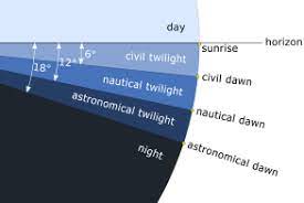
However they were able to study the early sunrise illusion near the horizon and came to the conclusion.
So they had a pretty tight sunrise to get that kind of accuracy.
So if that kind of accuracy was known and shared thousands of years ago..
Of course I could post that Syd Barrett wrote "see Emily play" in '67 because of the 20267 thing and it wouldn't make much sense unless I could also tie that in with the 867 (like the number of characters for the Vigenère Tableau key on the CIA Kryptos puzzle).
And they had clock accuracy of the Persian fenjaan thousands of years ago, so tossing a common log to measure speed in knots could have given fairly accurate distances if they recorded carefully. I've always believed most of that happened in the Mediterranean sea, but am Willing to think out of the box if necessary..
The lunar eclipse of 331 BC was seen in many distant locations on Earth and could have been a synchronization ~ 5 minutes at the start or end of the eclipse for all Earth locations viewing it. *Local* viewing times would have been recorded accurate to within a few minutes given the clock technology of the day and that would have determined the longitude of each location.
Noon shadow, Sunrise and sunset are usually cited for the time synchronization during the day (before published astronomical tables).
At first glance sunrise and sunset appear ambiguous.
However they were able to study the early sunrise illusion near the horizon and came to the conclusion.
Calculations of sunrise generally take this phenomenon into account by assuming that the atmosphere bends the sunlight by 0.5667 degrees
So they had a pretty tight sunrise to get that kind of accuracy.
So if that kind of accuracy was known and shared thousands of years ago..
Of course I could post that Syd Barrett wrote "see Emily play" in '67 because of the 20267 thing and it wouldn't make much sense unless I could also tie that in with the 867 (like the number of characters for the Vigenère Tableau key on the CIA Kryptos puzzle).
And they had clock accuracy of the Persian fenjaan thousands of years ago, so tossing a common log to measure speed in knots could have given fairly accurate distances if they recorded carefully. I've always believed most of that happened in the Mediterranean sea, but am Willing to think out of the box if necessary..
The lunar eclipse of 331 BC was seen in many distant locations on Earth and could have been a synchronization ~ 5 minutes at the start or end of the eclipse for all Earth locations viewing it. *Local* viewing times would have been recorded accurate to within a few minutes given the clock technology of the day and that would have determined the longitude of each location.
edit on 7-6-2022 by fromunclexcommunicate because: (no reason given)
a reply to: fromunclexcommunicate
.566 degrees is thirty miles out, Get the Angle between sunrise and the north star, and you would be pretty bang on. If you knew the suns latitude that particular day,
.566 degrees is thirty miles out, Get the Angle between sunrise and the north star, and you would be pretty bang on. If you knew the suns latitude that particular day,
a reply to: anonentity
Harte is probably correct about the time issue, there is a lot of cuneiform out there with coarse time keeping EG 2.5 hours after sunrise no mention of a minute scale. So in that situation recording a total eclipse from two different locations 120 degrees of longitude apart would have given a fair idea about local longitude. What was at debate was whether the distance per degree was measured more accurately by plodding Berber caravans traveling from the Nile as documented by Herodotus or ship navigators tossing common logs and keeping careful records of their speed.
Someone that spent their lives pouring over clay cuneiform tablets kept by some ancient observer with OCD might have yielded a eureka moment but people like Hawass keep the Egyptian stuff hidden. The eclipse seen in Egypt in 1338 might have resolved some longitude issues and I'm not sure of the date for the account of the theft of Horus moon eye.
a reply to: fromunclexcommunicate
I think people have an instinct for time. and animals more so, My dog wants her breakfast at bang on at eight in the morning, in fact, she nudges me awake at eight. I have checked the clock on numerous occasions. Also, reports of sailors with Ravens or other homing birds could have been used. The pigeons go up do a few circles then head home. For all, we know they could have asked a monkey what the time at Giza was. We only know they navigated well because they did it.
I think people have an instinct for time. and animals more so, My dog wants her breakfast at bang on at eight in the morning, in fact, she nudges me awake at eight. I have checked the clock on numerous occasions. Also, reports of sailors with Ravens or other homing birds could have been used. The pigeons go up do a few circles then head home. For all, we know they could have asked a monkey what the time at Giza was. We only know they navigated well because they did it.
a reply to: fromunclexcommunicate
You can't use sunrise to calculate longitude.
You can know it is dawn, but dawn comes at different times, depending on your longitude.
This is why a clock is a must.
Harte
You can't use sunrise to calculate longitude.
You can know it is dawn, but dawn comes at different times, depending on your longitude.
This is why a clock is a must.
Harte
"Local" longitude can be set to 0, so local is not the problem.
originally posted by: fromunclexcommunicate
Someone that spent their lives pouring over clay cuneiform tablets kept by some ancient observer with OCD might have yielded a eureka moment but people like Hawass keep the Egyptian stuff hidden. The eclipse seen in Egypt in 1338 might have resolved some longitude issues and I'm not sure of the date for the account of the theft of Horus moon eye.
Try finding your longitude at sea with no clock. It's impossible. Can't be done.
Never happened.
Also, NOTHING in Egypt is "hidden" by anyone, much less Hawass - who hasn't been in charge there for over a decade now.
Harte
a reply to: Harte
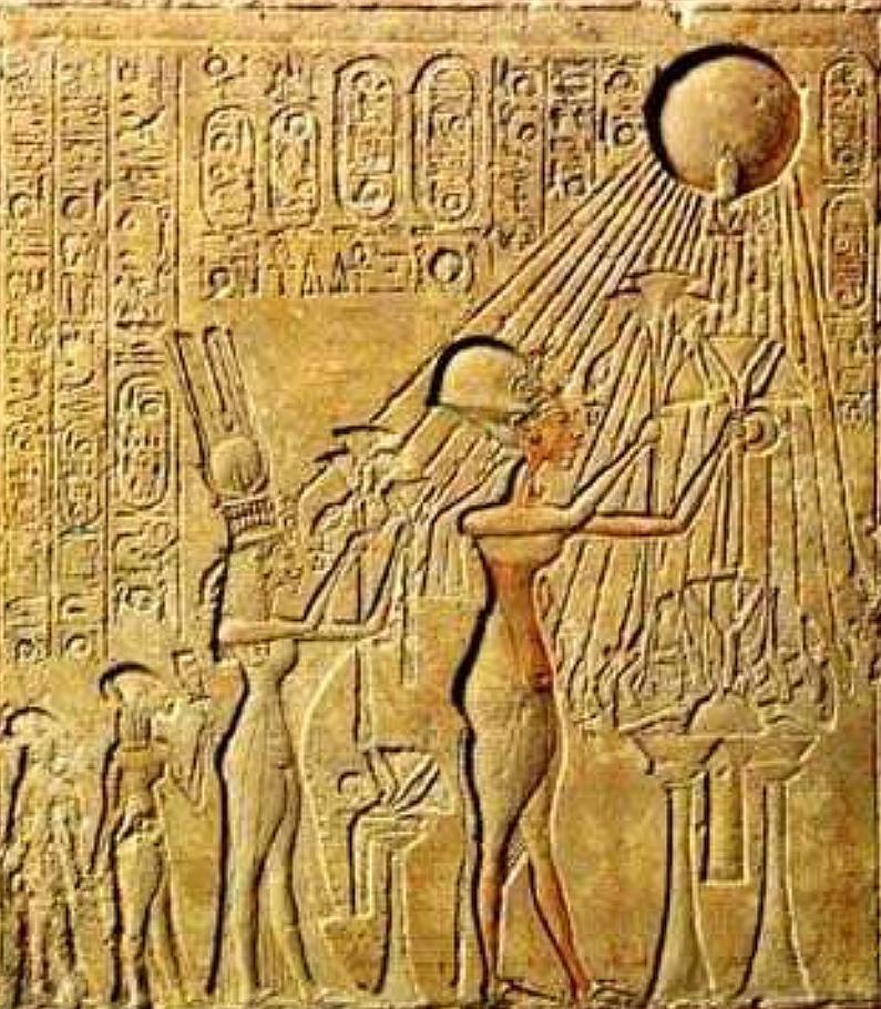
I was reading about the the curious Egyptian city of Amarda (apparently built on a prophecy).
It was ground zero for the darkest eclipse of the 14th century BC May 1338.
Art describing the city is a little abstract, these girls look like they spent the last 4 hours drinking Martini.
And pouring over the written evidence from Amarda we find clay tablets written in Akkadian cuneiform, the writing system of ancient Mesopotamia, rather than that of ancient Egypt? So potentially a Persian Gulf diplomatic link further East where Alexander the Great landed near Umm Qasr (in the same year as the legendary 331 eclipse).
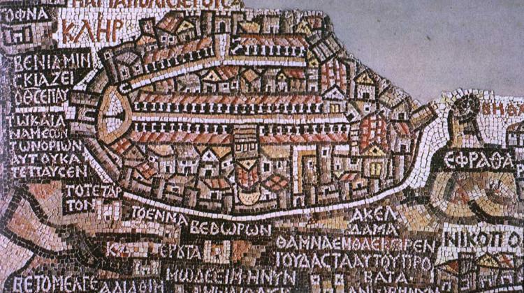
If the Great eclipse of 1338 was expected they might have set up sundial stations at different longitudes ahead of time to gather important Geo-positioning data based on time of observation for the eclipse. One such sundial was depicted in this ancient mosaic near Madaba, Jordon ~36 degrees east and the sun dial likely existed BC.
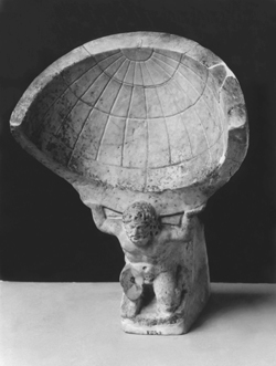
The more recognizable sundial in this case held on the shoulders of Atlas could have had an accuracy in the 100th of an hour range. The Atlas mountains would be much further west near the longitude of the Eye of the Sahara.
So I guess its not a "hidden" fact that after the shadow of the 1338 eclipse lifted the researchers in these cities may have recorded the event with their sun dials possibly resulting in recorded times differing by 8 hours or more?
And yet I couldn't find anything about a longitude experiment for that year except a bunch of double fisted martini drinking women someone sculpted?
The strangest thing is that after the eclipse the Amarda legacy just dried up and disappeared from history, no mention of the eclipse or these women that were planning the celebration of the new geopolitical children, for 1000 years nothing(until 331 BC).
But its not hidden...
I was reading about the the curious Egyptian city of Amarda (apparently built on a prophecy).
It was ground zero for the darkest eclipse of the 14th century BC May 1338.
Art describing the city is a little abstract, these girls look like they spent the last 4 hours drinking Martini.
And pouring over the written evidence from Amarda we find clay tablets written in Akkadian cuneiform, the writing system of ancient Mesopotamia, rather than that of ancient Egypt? So potentially a Persian Gulf diplomatic link further East where Alexander the Great landed near Umm Qasr (in the same year as the legendary 331 eclipse).
If the Great eclipse of 1338 was expected they might have set up sundial stations at different longitudes ahead of time to gather important Geo-positioning data based on time of observation for the eclipse. One such sundial was depicted in this ancient mosaic near Madaba, Jordon ~36 degrees east and the sun dial likely existed BC.
The more recognizable sundial in this case held on the shoulders of Atlas could have had an accuracy in the 100th of an hour range. The Atlas mountains would be much further west near the longitude of the Eye of the Sahara.
So I guess its not a "hidden" fact that after the shadow of the 1338 eclipse lifted the researchers in these cities may have recorded the event with their sun dials possibly resulting in recorded times differing by 8 hours or more?
And yet I couldn't find anything about a longitude experiment for that year except a bunch of double fisted martini drinking women someone sculpted?
The strangest thing is that after the eclipse the Amarda legacy just dried up and disappeared from history, no mention of the eclipse or these women that were planning the celebration of the new geopolitical children, for 1000 years nothing(until 331 BC).
But its not hidden...
originally posted by: fromunclexcommunicate
a reply to: Harte
I was reading about the the curious Egyptian city of Amarda (apparently built on a prophecy).
It was ground zero for the darkest eclipse of the 14th century BC May 1338.
Art describing the city is a little abstract, these girls look like they spent the last 4 hours drinking Martini.
And pouring over the written evidence from Amarda we find clay tablets written in Akkadian cuneiform, the writing system of ancient Mesopotamia, rather than that of ancient Egypt? So potentially a Persian Gulf diplomatic link further East where Alexander the Great landed near Umm Qasr (in the same year as the legendary 331 eclipse).
If the Great eclipse of 1338 was expected they might have set up sundial stations at different longitudes ahead of time to gather important Geo-positioning data based on time of observation for the eclipse. One such sundial was depicted in this ancient mosaic near Madaba, Jordon ~36 degrees east and the sun dial likely existed BC.
The more recognizable sundial in this case held on the shoulders of Atlas could have had an accuracy in the 100th of an hour range. The Atlas mountains would be much further west near the longitude of the Eye of the Sahara.
So I guess its not a "hidden" fact that after the shadow of the 1338 eclipse lifted the researchers in these cities may have recorded the event with their sun dials possibly resulting in recorded times differing by 8 hours or more?
And yet I couldn't find anything about a longitude experiment for that year except a bunch of double fisted martini drinking women someone sculpted?
The strangest thing is that after the eclipse the Amarda legacy just dried up and disappeared from history, no mention of the eclipse or these women that were planning the celebration of the new geopolitical children, for 1000 years nothing(until 331 BC).
But its not hidden...
I don't see what this has to do with ancient navigation.
But, yes, there was correspondence between Mesopotamia and Egypt, and usually they used cuneiform to write each other about this or that.
Harte
originally posted by: fromunclexcommunicate
a reply to: anonentity
Harte is probably correct about the time issue, there is a lot of cuneiform out there with coarse time keeping EG 2.5 hours after sunrise no mention of a minute scale. So in that situation recording a total eclipse from two different locations 120 degrees of longitude apart would have given a fair idea about local longitude. What was at debate was whether the distance per degree was measured more accurately by plodding Berber caravans traveling from the Nile as documented by Herodotus or ship navigators tossing common logs and keeping careful records of their speed.
Only possible with an accurate clock AND a relatively fast-moving ship and only if you're in the ocean. Most travel was done on rivers.
They eventually had water clocks but those only work on land. Same with time-keeping candles...they need someplace out of the wind and where it's not going to move (changes burn rate)
a reply to: Byrd
People that knew exactly where the (top of the hill) for the moon was going to be in a future eclipse a few decades in the future might have used a different approach to determine longitude. The OP's video talks about that, and an approach using retrograde lunar motion.
Water clocks work everywhere but they are primarily helpful sailing on a long reach off the wind. If you knew you were traveling 7 knots and you wanted to sail on that heading 56 nautical miles at night you would turn from your pole star heading at 8 hours. If you were traveling 8 knots you would turn when the 7 hour circle line of your float just went under the water surface.
Earth's circumference at the tropic of Cancer was calculated thousands of years before the Eratosthenes of Cyrene claim.
That appears to be the truth the video is disclosing.
Oh dear.
"Amarna." Armada is a fleet of ships.
The area of "ground zero" is actually 72 miles in width and 125 miles long So it included a number of Egyptian cities and villages.
You've just collapsed 3,000 years of history and tried to make it a far shorter time period. Egypt at the time of Amarna owned a big strip of land up along the Arabian coast to Palestine and Canaan and had been since the days of Hatshepsut and Thutmose III.
However, these were subjugated kingdoms and these are letters from the vassal kings to Akhenaten (Akhenaten demands presents, they ask for gold and troops, Akhenaten usually ignores them and asks for women and gold.)
They were in conflict with the Babylonian Empire, the Hittites, Assyrians, and Mittani ...the first conflict of superpowers (large empires) in the ancient world.
There's no evidence that they did and none of the mathematics in the period afterwards shows them making use of this information. They don't get to the "earth is a sphere" realization until 700 AD, and then it's the Chaldeans who do that.
You're really unfamiliar with Egyptian history, I see. The eclipse had nothing to do with the city being abandoned. Akhenaten's death BEFORE the eclipse, the fact that he was universally hated, the fuss over who succeeds him, the political maneuvering of the great cities to bring the capital back to those spots, and the fact that it was so far from fields and sources that everything had to be imported meant people abandoned it pretty quickly.
originally posted by: fromunclexcommunicate
a reply to: Harte
I was reading about the the curious Egyptian city of Amarda (apparently built on a prophecy).
"Amarna." Armada is a fleet of ships.
It was ground zero for the darkest eclipse of the 14th century BC May 1338.
The area of "ground zero" is actually 72 miles in width and 125 miles long So it included a number of Egyptian cities and villages.
And pouring over the written evidence from Amarda we find clay tablets written in Akkadian cuneiform, the writing system of ancient Mesopotamia, rather than that of ancient Egypt? So potentially a Persian Gulf diplomatic link further East where Alexander the Great landed near Umm Qasr (in the same year as the legendary 331 eclipse).
You've just collapsed 3,000 years of history and tried to make it a far shorter time period. Egypt at the time of Amarna owned a big strip of land up along the Arabian coast to Palestine and Canaan and had been since the days of Hatshepsut and Thutmose III.
However, these were subjugated kingdoms and these are letters from the vassal kings to Akhenaten (Akhenaten demands presents, they ask for gold and troops, Akhenaten usually ignores them and asks for women and gold.)
They were in conflict with the Babylonian Empire, the Hittites, Assyrians, and Mittani ...the first conflict of superpowers (large empires) in the ancient world.
So I guess its not a "hidden" fact that after the shadow of the 1338 eclipse lifted the researchers in these cities may have recorded the event with their sun dials possibly resulting in recorded times differing by 8 hours or more?
There's no evidence that they did and none of the mathematics in the period afterwards shows them making use of this information. They don't get to the "earth is a sphere" realization until 700 AD, and then it's the Chaldeans who do that.
The strangest thing is that after the eclipse the Amarda legacy just dried up and disappeared from history, no mention of the eclipse or these women that were planning the celebration of the new geopolitical children, for 1000 years nothing(until 331 BC).
You're really unfamiliar with Egyptian history, I see. The eclipse had nothing to do with the city being abandoned. Akhenaten's death BEFORE the eclipse, the fact that he was universally hated, the fuss over who succeeds him, the political maneuvering of the great cities to bring the capital back to those spots, and the fact that it was so far from fields and sources that everything had to be imported meant people abandoned it pretty quickly.
originally posted by: fromunclexcommunicate
a reply to: Byrd
People that knew exactly where the (top of the hill) for the moon was going to be in a future eclipse a few decades in the future might have used a different approach to determine longitude. The OP's video talks about that, and an approach using retrograde lunar motion.
One can calculate this many different ways. However, let me ask the questions that videos make you forget to ask:
* what's the basis for this claim? In other words, what seals and tablets show that these calculations were in use? (not someone's claim. Where's the stuff in the museums?
* there's a lot of astronomical tablets. Which ones show this calculation (or how to do this calculation)?
If the answer is "uhhh....?' then the video could be completely making stuff up. You know; like saying that cops can't see cars with silver paint that are speeding because the color gray isn't as noticeable as the color red (I just made that up but if I waved the right sort of fake facts around it looks real.)
Water clocks work everywhere but they are primarily helpful sailing on a long reach off the wind.
No, they're not workable on boats. Fluid spills, drops fall irregularly because of the motion of the boat. That's why the Royal Navy didn't use them on boats and paid a fortune for a reliable clock.
If you knew you were traveling 7 knots and you wanted to sail on that heading 56 nautical miles at night you would turn from your pole star heading at 8 hours. If you were traveling 8 knots you would turn when the 7 hour circle line of your float just went under the water surface.
They hugged the coastline and landed or docked at night. Seriously.
The Polynesians, with their big shallow draft canoes and observational-based maps, they might have done something like that. But the Middle East did not and they relied on the Phoenicians when they wanted long-distance water travel.
Earth's circumference at the tropic of Cancer was calculated thousands of years before the Eratosthenes of Cyrene claim.
That appears to be the truth the video is disclosing.
a reply to: fromunclexcommunicate
The GP proves that the cardinal points were worked out with a high degree of accuracy. All you would need is a model globe with the mark on it where the GP stood. Probably the thirtieth parallel when it was built. since there are three hundred and sixty degrees in a circle, you then scribe on the latitudes and longitudes. Then at the top of the Pyramid, you read your magnetic deviation, (the angle from True north and magnetic north). Then scribe a line on the model globe. Do the same thing a few hundred miles away. On your model globe, true north will cross at the geographic north pole and the same with the magnetic north pole. You now have two points on the globe from which to triangulate your position on the globe. All you have to do now is fill in the landmasses on your model globe. The angles will be peculiar to every different position on the model globe. Finding true north at sea would mean using the current polar star. But what is more relevant on an Island you could have a few stones set up to get a better reading. The island gets drawn on the Model globe for posterity.
Then due to times when the inevitable occurs, trade seems to stop and civilizations fall, others rise, then like the Phonecians they would rather sink their ships rather than give away their advantage of trade secrets. Like when the Magnetic pole decides to migrate.
edit on 10-6-2022 by anonentity because: (no reason given)
a reply to: anonentity
You can walk the 360 degrees of longitude in less than a minute at the poles but its about 1021 kilometers between just 10 degrees of longitude at the tropic of Cancer. This was all worked out long before they started using eclipses to wake the public to their local longitude(or not if you are a flat earther like Byrd).
I'm curious now about that device they found in the Papua New Guinea cave that dated from over 2000 BC. I thought it wasn't until the optics were good enough to use the moons of Jupiter for navigation accuracy that they could resolve longitude to an accuracy of less than 10 miles. The Antikythera device dated about 80 AD apparently had anti recoil shaped teeth on the gearing so there may have been some rare mechanical ship clocks that existed in the bronze age.
The Earth was flat till after the printing press was invented in 1400 AD and Copernicus published, that is the official story LOL.
originally posted by: fromunclexcommunicate
a reply to: Byrd
People that knew exactly where the (top of the hill) for the moon was going to be in a future eclipse a few decades in the future might have used a different approach to determine longitude. The OP's video talks about that, and an approach using retrograde lunar motion.
Nope.
Can't do it without timing.
It's impossible, like I said. You can give it up now.
Harte
new topics
-
WF Killer Patents & Secret Science Vol. 1 | Free Energy & Anti-Gravity Cover-Ups
General Conspiracies: 1 minutes ago -
Hurt my hip; should I go see a Doctor
General Chit Chat: 50 minutes ago -
Israel attacking Iran again.
Middle East Issues: 1 hours ago -
Michigan school district cancels lesson on gender identity and pronouns after backlash
Education and Media: 2 hours ago -
When an Angel gets his or her wings
Religion, Faith, And Theology: 2 hours ago -
Comparing the theology of Paul and Hebrews
Religion, Faith, And Theology: 3 hours ago -
Pentagon acknowledges secret UFO project, the Kona Blue program | Vargas Reports
Aliens and UFOs: 4 hours ago -
Boston Dynamics say Farewell to Atlas
Science & Technology: 4 hours ago -
I hate dreaming
Rant: 5 hours ago -
Man sets himself on fire outside Donald Trump trial
Mainstream News: 7 hours ago
top topics
-
The Democrats Take Control the House - Look what happened while you were sleeping
US Political Madness: 8 hours ago, 18 flags -
In an Historic First, In N Out Burger Permanently Closes a Location
Mainstream News: 10 hours ago, 16 flags -
A man of the people
Medical Issues & Conspiracies: 15 hours ago, 11 flags -
Biden says little kids flip him the bird all the time.
Politicians & People: 7 hours ago, 8 flags -
Man sets himself on fire outside Donald Trump trial
Mainstream News: 7 hours ago, 7 flags -
Pentagon acknowledges secret UFO project, the Kona Blue program | Vargas Reports
Aliens and UFOs: 4 hours ago, 6 flags -
Israel attacking Iran again.
Middle East Issues: 1 hours ago, 5 flags -
Michigan school district cancels lesson on gender identity and pronouns after backlash
Education and Media: 2 hours ago, 4 flags -
4 plans of US elites to defeat Russia
New World Order: 17 hours ago, 4 flags -
Boston Dynamics say Farewell to Atlas
Science & Technology: 4 hours ago, 4 flags
active topics
-
WF Killer Patents & Secret Science Vol. 1 | Free Energy & Anti-Gravity Cover-Ups
General Conspiracies • 0 • : 727Sky -
Boston Dynamics say Farewell to Atlas
Science & Technology • 5 • : Caver78 -
Hurt my hip; should I go see a Doctor
General Chit Chat • 7 • : randomtangentsrme -
Biden says little kids flip him the bird all the time.
Politicians & People • 16 • : stelth2 -
When an Angel gets his or her wings
Religion, Faith, And Theology • 2 • : stelth2 -
MULTIPLE SKYMASTER MESSAGES GOING OUT
World War Three • 51 • : Zaphod58 -
Israel attacking Iran again.
Middle East Issues • 19 • : stelth2 -
Pentagon acknowledges secret UFO project, the Kona Blue program | Vargas Reports
Aliens and UFOs • 7 • : Ophiuchus1 -
-@TH3WH17ERABB17- -Q- ---TIME TO SHOW THE WORLD--- -Part- --44--
Dissecting Disinformation • 549 • : cherokeetroy -
In an Historic First, In N Out Burger Permanently Closes a Location
Mainstream News • 9 • : VariedcodeSole