It looks like you're using an Ad Blocker.
Please white-list or disable AboveTopSecret.com in your ad-blocking tool.
Thank you.
Some features of ATS will be disabled while you continue to use an ad-blocker.

Heraldry of Russian cities
page: 2share:
originally posted by: Asktheanimals
I had several guesses what your third city would be, I just got lucky.
Kiev, Stalingrad(Volvograd) and Odessa all came to mind as well.
What did you think of my theory about Kruschev?
I have yet to hear anyone explain why he would want to move it to a different district politically.
Are political areas called Oblasts btw?
Unlike Odessa, Kiev has belonged to Little Russia (Малороссия) - ic.pics.livejournal.com...
I cannot know the motives that prompted Khrushchev to transfer Crimea to Ukraine.
I think this was done for the sake of practical convenience.
There was no land route from the RSFSR to the Crimea. (It was possible to get to the Crimea only through the territory of Ukraine.)
And only in 2018 the Crimean bridge (19 kilometers long) was built.
In 2018, it was opened to road traffic and in December 2019, railway traffic was opened.
There are several types of subjects of the federation in Russia: Republics (Республика), Regions (Область), Territories (Край) and Autonomous Okrugs (Автономный Округ).
edit on 4 21 2022 by turretless because: (no reason given)
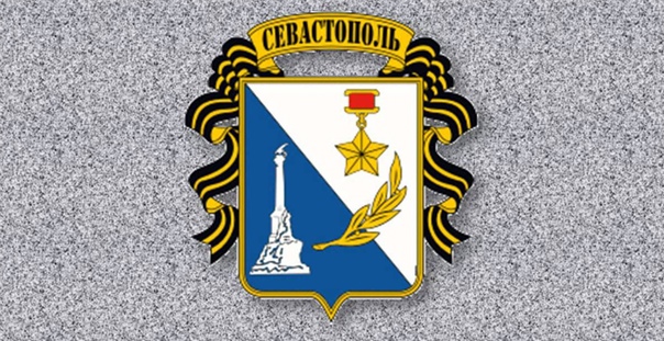
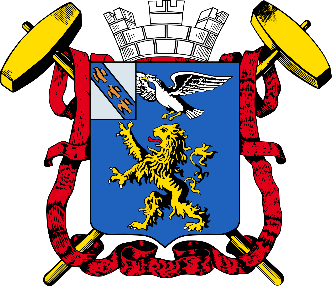
Two Soviet emblems of Sevastopol (official and unofficial but often used)
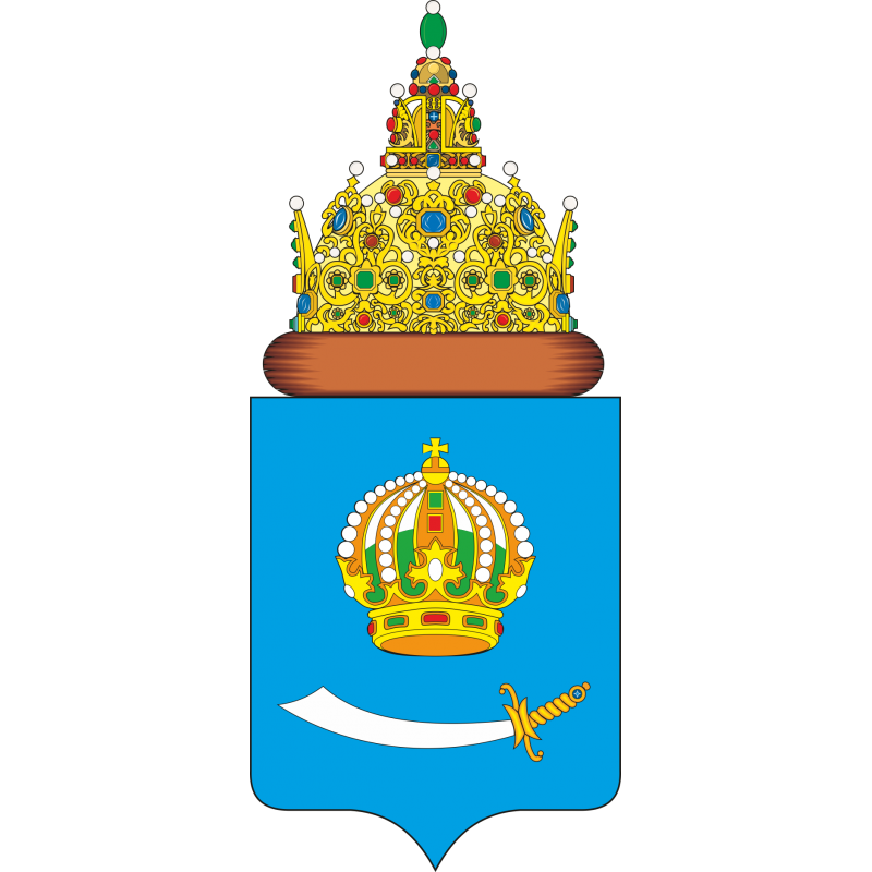
(Sevastopol is the third city of federal significance)
Sevastopol is located in Crimea, but it is not part of the Republic of Crimea. It and some territories adjacent to it are a separate subject of the Russian Federation (a city of federal significance).
Sevastopol was founded in 1783 as a naval port and city in the Akhtiar Bay. Its name consists of two Greek words: σεβαστός (highly respected, venerable, sacred) and πόλις (the town).
From 1797 to 1826 it was called Akhtiar (Ахтиар).
The population of Sevastopol (with adjacent territories) is 522,057 (2022).
During the Crimean War of 1853-1856, Russia fought against a coalition of the British, French, Ottoman empires and the Kingdom of Sardinia. On September 2, 1854, the 62,000th united army of England, France and Turkey landed near Yevpatoriya and headed for Sevastopol, which was defended by 25,000 sailors and 7,000 garrison of the city. The advantage of the attacking fleet was also overwhelming, which is why it was later decided to sink Russian ships to block the entrance to the Sevastopol Bay.
And on the Soviet emblem you can see the monument to the scuttled ships.
During the Second World War, Sevastopol became the scene of heroic resistance to the German-Romanian troops in the Crimea. It was stormed from October 30, 1941 - July 4, 1942.
For this, Sevastopol received the Gold Star medal, which you can also see on the Soviet emblem.
The headquarters of the Black Sea Fleet is located in Sevastopol.
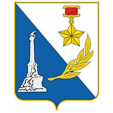
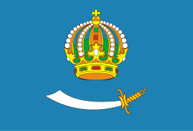
The emblem of the city is a French-shaped heraldic shield beveled to the right with a ratio of width to height of 8 to 9. On the upper right side of the emblem, on a silver (light gray) background, the Gold Star medal is depicted.
On the lower left side of the emblem on an azure (blue) background there is a silhouette of the monument to the Scuttled Ships of silver (light gray) color (view from the shore of the bay).
Compositionally, the two backgrounds are united by a golden laurel branch, symbolizing the glory of the defenders of Sevastopol. The shield has a golden outer border.
(According to the authors, the emblem of Sevastopol on its shield connected two historical eras. On a blue background there is a Monument to the Scuttled Ships, this is the first defense. On white there is a "Gold Star", this is an award for victory in the Great Patriotic War. And between them is a laurel branch - a symbol of glory and courage.)
The emblem of Sevastopol (1893)
In a red shield is a silver griffin (with red eyes and tongue). In the free part of the shield is the emblem of the Tauride province. Above the shield is the ancient Royal crown, on which stands the Imperial eagle. Behind the shield there are two crossed gold anchors, and on the sides of the shield there are two red banners connected by a ribbon of the Order of St. Great Martyr and Victorious George. On the left banner is the gold cypher of the Sovereign Emperor Nicholas I, and on the right is the same cypher of the Sovereign Emperor Alexander II, both cyphers are decorated with the Imperial crown and the chain of the Order of St. Apostle Andrew the First-Called.
The griffin was the emblem of the ancient Greek Chersonese.
The griffin is the guardian of peace of the Sevastopol land.
At present, the Soviet emblem remains the emblem of Sevastopol, but the question is open. There are numerous supporters of the old imperial emblem, but there are also supporters of the Soviet emblem, and for several decades there has been controversy and struggle between them.
In addition, other variants of the emblem for Sevastopol were repeatedly proposed.
(Sevastopol is the third city of federal significance)
Sevastopol is located in Crimea, but it is not part of the Republic of Crimea. It and some territories adjacent to it are a separate subject of the Russian Federation (a city of federal significance).
Sevastopol was founded in 1783 as a naval port and city in the Akhtiar Bay. Its name consists of two Greek words: σεβαστός (highly respected, venerable, sacred) and πόλις (the town).
From 1797 to 1826 it was called Akhtiar (Ахтиар).
The population of Sevastopol (with adjacent territories) is 522,057 (2022).
During the Crimean War of 1853-1856, Russia fought against a coalition of the British, French, Ottoman empires and the Kingdom of Sardinia. On September 2, 1854, the 62,000th united army of England, France and Turkey landed near Yevpatoriya and headed for Sevastopol, which was defended by 25,000 sailors and 7,000 garrison of the city. The advantage of the attacking fleet was also overwhelming, which is why it was later decided to sink Russian ships to block the entrance to the Sevastopol Bay.
And on the Soviet emblem you can see the monument to the scuttled ships.
During the Second World War, Sevastopol became the scene of heroic resistance to the German-Romanian troops in the Crimea. It was stormed from October 30, 1941 - July 4, 1942.
For this, Sevastopol received the Gold Star medal, which you can also see on the Soviet emblem.
The headquarters of the Black Sea Fleet is located in Sevastopol.
The emblem of the city is a French-shaped heraldic shield beveled to the right with a ratio of width to height of 8 to 9. On the upper right side of the emblem, on a silver (light gray) background, the Gold Star medal is depicted.
On the lower left side of the emblem on an azure (blue) background there is a silhouette of the monument to the Scuttled Ships of silver (light gray) color (view from the shore of the bay).
Compositionally, the two backgrounds are united by a golden laurel branch, symbolizing the glory of the defenders of Sevastopol. The shield has a golden outer border.
(According to the authors, the emblem of Sevastopol on its shield connected two historical eras. On a blue background there is a Monument to the Scuttled Ships, this is the first defense. On white there is a "Gold Star", this is an award for victory in the Great Patriotic War. And between them is a laurel branch - a symbol of glory and courage.)
The emblem of Sevastopol (1893)
In a red shield is a silver griffin (with red eyes and tongue). In the free part of the shield is the emblem of the Tauride province. Above the shield is the ancient Royal crown, on which stands the Imperial eagle. Behind the shield there are two crossed gold anchors, and on the sides of the shield there are two red banners connected by a ribbon of the Order of St. Great Martyr and Victorious George. On the left banner is the gold cypher of the Sovereign Emperor Nicholas I, and on the right is the same cypher of the Sovereign Emperor Alexander II, both cyphers are decorated with the Imperial crown and the chain of the Order of St. Apostle Andrew the First-Called.
The griffin was the emblem of the ancient Greek Chersonese.
The griffin is the guardian of peace of the Sevastopol land.
At present, the Soviet emblem remains the emblem of Sevastopol, but the question is open. There are numerous supporters of the old imperial emblem, but there are also supporters of the Soviet emblem, and for several decades there has been controversy and struggle between them.
In addition, other variants of the emblem for Sevastopol were repeatedly proposed.
originally posted by: Asktheanimals
What did you think of my theory about Kruschev?
I have yet to hear anyone explain why he would want to move it to a different district politically.
I want to continue my answer to your question.
I want to translate the main parts from a certain transcript so that you can see the gist of the argument - krym.rusarchives.ru...
Transcript of the meeting of the Presidium of the Supreme Council of the USSR on the transfer of the Crimean region from the RSFSR to the Ukrainian SSR
February 19, 1954
......................
Mikhail Tarasov (Chairman of the Presidium of the Supreme Council of the RSFSR):
Comrades, the issue of transferring the Crimean Region from the Russian Federation to the Ukrainian SSR has been submitted for consideration by the Presidium of the Supreme Council of the USSR.
The Crimean region, as is known, occupies the entire Crimean peninsula and territorially adjoins the Ukrainian Republic, being, as it were, a natural continuation of the southern steppes of Ukraine. The economy of the Crimean region is closely connected with the economy of the Ukrainian SSR. For geographical and economic reasons, the transfer of the Crimean region to the fraternal Ukrainian Republic is expedient and meets the general interests of the Soviet state.
The Ukrainian people have long linked their fate with the Russian people. For many centuries they fought together against common enemies - tsarism, feudal lords and capitalists, as well as against foreign invaders. With the victory of the Great October Socialist Revolution, the centuries-old friendship between the Ukrainian and Russian people was further strengthened, and the economic and cultural ties between Crimea and Ukraine were further strengthened.
The issue of transferring the Crimean region to the Ukrainian Republic is being considered at a time when the peoples of the Soviet Union are celebrating a significant event - the 300th anniversary of the reunification of Ukraine with Russia, which played a huge progressive role in the political, economic and cultural development of the Ukrainian and Russian people.
The transfer of the Crimean region to the Ukrainian Republic is in the interests of strengthening the friendship of the peoples of the Great Soviet Union, will further strengthen the fraternal ties between the Ukrainian and Russian peoples, and will further flourish Soviet Ukraine, the development of which our Party and government have always paid great attention to.
The Presidium of the Supreme Council of the RSFSR, with the participation of representatives of the executive committees of the Crimean Regional and Sevastopol City Councils of Working People's Deputies, considered the proposal of the Council of Ministers of the RSFSR to transfer the Crimean Region to the Ukrainian SSR.
Taking into account the common economy, territorial proximity and close economic and cultural ties between the Crimean region and the Ukrainian SSR, and also bearing in mind the consent of the Presidium of the Supreme Council of the Ukrainian SSR, the Presidium of the Supreme Council of the RSFSR considers it expedient to transfer the Crimean region to the Ukrainian Soviet Socialist Republic.
......................................................
Demyan Korotchenko (Chairman of the Presidium of the Supreme Council of the Ukrainian SSR):
Comrades! The Presidium of the Supreme Council of the Ukrainian SSR fully agrees with the proposal to transfer the Crimean Oblast from the Russian Soviet Federative Socialist Republic to the Ukrainian SSR, which was set forth here by Comrade Tarasov, Chairman of the Supreme Council of the RSFSR.
The Presidium of the Supreme Council of the Ukrainian Soviet Socialist Republic expresses its heartfelt gratitude to the great Russian fraternal people for the exceptionally remarkable act of fraternal assistance that is being discussed at today's meeting.
The transfer of the Crimea to the Ukrainian SSR, taking into account the common economic development, territorial proximity and the growing economic and cultural ties between the Ukrainian Republic and the Crimean region, is quite expedient and is the greatest friendly act, testifying to the boundless trust and love of the Russian people for the Ukrainian people. The Ukrainian people know very well that to be in fraternal friendship with the great Russian people, with all the peoples of our country, means victoriously following the path indicated by the Communist Party, along the path of a free and happy life, along the path to communism.
The working people of Soviet Ukraine firmly remember and will not forget for centuries that only thanks to the friendship, help and support of the fraternal [Russian] people and other peoples of our Motherland, thanks to the constant care of the Central Committee of the Communist Party of the Soviet Union and the Soviet government, the Ukrainian people achieved tremendous success in the flourishing of the economy and culture - national in form, socialist in content. Today the Ukrainian people, together with other peoples of the Soviet Union, are successfully fighting for the fulfillment of the five-year plan, for the further growth of the might of our socialist state.
One of the clearest manifestations of the uninterrupted friendship of the peoples of the USSR is the 300th anniversary of the reunification of Ukraine with Russia, celebrated this year as a great national holiday of the Ukrainian, Russian and all peoples of the Soviet Union.
The Presidium of the Supreme Council of the Ukrainian SSR asks the Presidium of the Supreme Council of the USSR to approve the joint proposal of the Presidium of the Supreme Council of the Russian Soviet Federative Socialist Republic of the Presidium of the Supreme Council of the Ukrainian Soviet Socialist Republic on the transfer of Crimea from the RSFSR to the Ukrainian SSR. This decision will be met with gratitude and approval by the entire Ukrainian people.
Let me assure you that the Ukrainian government will pay due attention to the further development of the Crimean national economy and the improvement of the material and cultural well-being of the working people of the Crimean region.
to be continued
Transcript of the meeting of the Presidium of the Supreme Council of the USSR on the transfer of the Crimean region from the RSFSR to the Ukrainian
SSR
to be continued
Nikolai Shvernik (candidate member of the Presidium of the Central Committee of the CPSU):
Comrade members of the Presidium, the proposal to transfer the Crimean region from the Russian Soviet Federative Socialist Republic to the Ukrainian Soviet Socialist Republic is of great historical significance, which is evidence of the fraternal friendship between the peoples of the two great socialist republics.
In the national economy of the USSR, the Crimean region plays a significant role as a region of ferrous metallurgy, viticulture, winemaking, the canning and fishing industries, animal husbandry, and as a region cultivating high-quality wheat. The Crimean region borders on the territory of the Ukrainian SSR. This fact led to the development of common cultural and economic ties between the Crimean region and Soviet Ukraine.
All this to a certain extent determines the transfer of the Crimean region to the Ukrainian Soviet Socialist Republic.
Such a transfer of the large region, rich in raw materials, with a developed large-scale industry, valuable natural healing factors, can be carried out only in the conditions of our socialist country, forever freed from the oppression of capitalists and landlords, in a country where concern for man (and his material wealth and cultural needs) is in the foreground.
There is no doubt that this important historical act will serve the cause of further continuous economic and economic development of the Crimean region as part of the Ukrainian SSR. It should be pointed out that the Crimea is a health resort of world importance. In its numerous sanatoriums and rest homes, a huge number of workers are treated and rest.
In terms of its scale and therapeutic factors, the Crimea is a well-known first-class resort, and there is no doubt that it will be further developed as part of the Ukrainian Soviet Socialist Republic in order to more effectively satisfy the demands of the working people that are growing day by day.
The Crimean region will develop on an ever larger scale and economically, expanding the cultivation of valuable crops of grapes, tobacco, wheat, and increasing the productivity of public animal husbandry.
The transfer of the Crimean Oblast to the Ukrainian SSR will be greeted by our people with great enthusiasm, for they see in this a guarantee of the wise leadership of the Communist Party and the concern of the Soviet government for the further prosperity of Soviet Ukraine.
The unbreakable and eternal friendship of the Ukrainian and Russian peoples will be the key to the further economic strengthening of the Soviet Union, which is developing along the path of communism.
I fully support the proposal to transfer the Crimean region to the Ukrainian Soviet Socialist Republic.
Sharaf Rashidov (Chairman of the Presidium of the Supreme Council of the Uzbek SSR):
Comrades, the transfer of the Crimean region to the Soviet Ukraine is in the common interests of our great Motherland. This important act of state will contribute to the development of the Ukrainian economy and further strengthen the unbreakable friendship between the Ukrainian and Russian peoples. Our Party has rallied all the peoples of the Soviet Union into a single, friendly family. Our Party, at all stages of its heroic struggle, preserved and strengthened the friendship of the peoples of the USSR and the might of our Soviet state. Our Party teaches that as long as this friendship is alive and well, we are not afraid of either internal or external enemies.
The transfer of the Crimean region to the Ukrainian SSR takes place on significant days when the entire Soviet people celebrate the 300th anniversary of the reunification of Ukraine with Russia, and will be a new bright manifestation of the wise policy of the Communist Party aimed at the all-round development and prosperity of the creative and spiritual forces of all the peoples of our country. This is possible only in our country, where there is no national strife and national contradictions, where the life of all Soviet people proceeds in an atmosphere of peaceful creative labor for the sake of peace and happiness of all mankind, where concern for man is the highest law of the Soviet government and the Communist Party.
I warmly support the joint proposal of the Presidium of the Supreme Council of the RSFSR and the Presidium of the Supreme Council of the Ukrainian SSR on the transfer of the Crimean region to the Ukrainian Soviet Socialist Republic.
Otto Kuusinen (Chairman of the Presidium of the Supreme Soviet of the Karelian-Finnish SSR):
Comrades! The joint presentation of the Presidium of the Supreme Council of the RSFSR and the Presidium of the Supreme Council of the Ukrainian SSR on the transfer of the Crimean region to the Ukrainian SSR deserves especially great attention, primarily in a fundamental respect, namely, that it is a new and clear evidence of ongoing in our country, a country of socialist democracy, the Leninist policy of indestructible friendship between fraternal peoples. Only in our country is it possible that such a great people as the Russians, without any hesitation, generously transfer one of their regions to another fraternal people. Only in our country is it possible when such important questions as the territorial transfer of certain regions to one or another republic are resolved without any difficulty, with complete coordination, guided solely by considerations of expediency, economic and cultural development, guided by the common interests of the Soviet state and the interests of further strengthening friendship and trust between peoples.
From this principled point of view, one can only welcome the joint proposal of the Presidium of the Supreme Council of the RSFSR and the Presidium of the Supreme Council of the Ukrainian SSR on the transfer of the Crimean region to the Ukrainian SSR. From the point of view of practical and political expediency, this idea is quite justified.
Therefore, I fully support the proposal that the Presidium of the Supreme Council of the USSR approve the joint submission of the Presidium of the Supreme Council of the RSFSR and the Presidium of the Supreme Council of the Ukrainian SSR.
to be continued
Transcript of the meeting of the Presidium of the Supreme Council of the USSR on the transfer of the Crimean region from the RSFSR to the Ukrainian
SSR
Kliment Voroshilov (Chairman of the Presidium of the Supreme Council of the USSR):
The decision of the Presidium of the Supreme Council of the USSR was adopted unanimously.
Comrades, the decision of the Presidium of the Supreme Council of the USSR on the joint proposal of the Presidium of the Supreme Council of the RSFSR and the Presidium of the Supreme Council of the Ukrainian SSR on the transfer of the Crimean region from the Russian Soviet Socialist Republic to the Ukrainian Soviet Socialist Republic is evidence of the further strengthening of the unity and indestructible friendship of the Russian and Ukrainian peoples in great mighty fraternal family of the peoples of the Union of Soviet Socialist Republics. This momentous act of great state significance once again confirms that relations between the sovereign union socialist republics in the USSR are based on genuine equality and real understanding and respect for mutual interests aimed at the prosperity of all union republics.
In history there is not and cannot be such relations between states. In the past, and especially under capitalism, the very basis of relations between states was the desire for territorial conquest, the desire of strong states to profit off the territories of weak countries. Only under the conditions of the Union of Soviet Socialist Republics is such a just solution of all questions between the Union republics possible, decisions based on economic, economic expediency, with complete mutual friendship and fraternal cooperation of their peoples. The transfer of the Crimean Region from the RSFSR to the Ukrainian SSR is in the interests of the Russian and Ukrainian peoples, in the interests of the entire state of the Union of Soviet Socialist Republics.
The Crimean region, in its historical development, in its territorial and economic position, is of great importance for the entire Soviet state. Both in the distant and in the recent past, enemies have repeatedly tried to take the Crimean peninsula from Russia, use it to plunder and ruin Russian and Ukrainian lands, and create a base there for attacking Russia and Ukraine. But the Russian and Ukrainian peoples, in their joint struggle, more than once brutally beat the impudent invaders and threw them out of the borders of Ukraine and the Crimea. Ukraine and Crimea are closely linked by a commonality of economic interests - this was eloquently mentioned here both by those who made the reports and by other comrades who spoke. Cultural ties between Crimea and Ukraine have especially increased and deepened. The transfer of the Crimean region to the Ukrainian SSR will undoubtedly further strengthen these traditional ties.
Comrades, this act of friendship is taking place at a time when the Soviet people are solemnly celebrating the remarkable historical date of the 300th anniversary of Russia's reunification with Ukraine. This is a great traditional holiday not only for the Ukrainian people, but for all the peoples of the USSR. Friendship of peoples is one of the foundations of our multinational great Soviet state, the source of its irresistible strength, its flourishing and might. We know and rejoice that the Russian, Ukrainian and other peoples of our vast country will continue to develop and strengthen their fraternal friendship. May our great Motherland, the fraternal Union of Soviet Socialist Republics, grow stronger and develop!
I want to continue with a story about a unique subject of the federation, which is also a Russian gift.
The emblem of the Jewish Autonomous Region (Еврейская автономная область)
This is the only subject of the federation with the status of the autonomous region.
Due to the fact that the Jews did not have their own state, the RSFSR decided to give them land.
On May 7, 1934, this land received this status, but the land itself was allocated to Jews earlier in 1928.
Here's what they got.
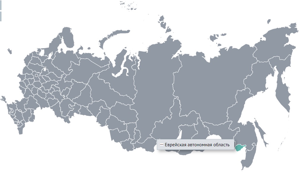
The region is located on the border with China.
It is an area of 36,271 square kilometers (Israel has an area of 22,072 square kilometers).
The population of the region is 153,831 (2022).
Jews have never made up the majority of the population in this area. Their largest number was in 1948, it was equal to 28 thousand. Now Jews make up about 1% of the population there.
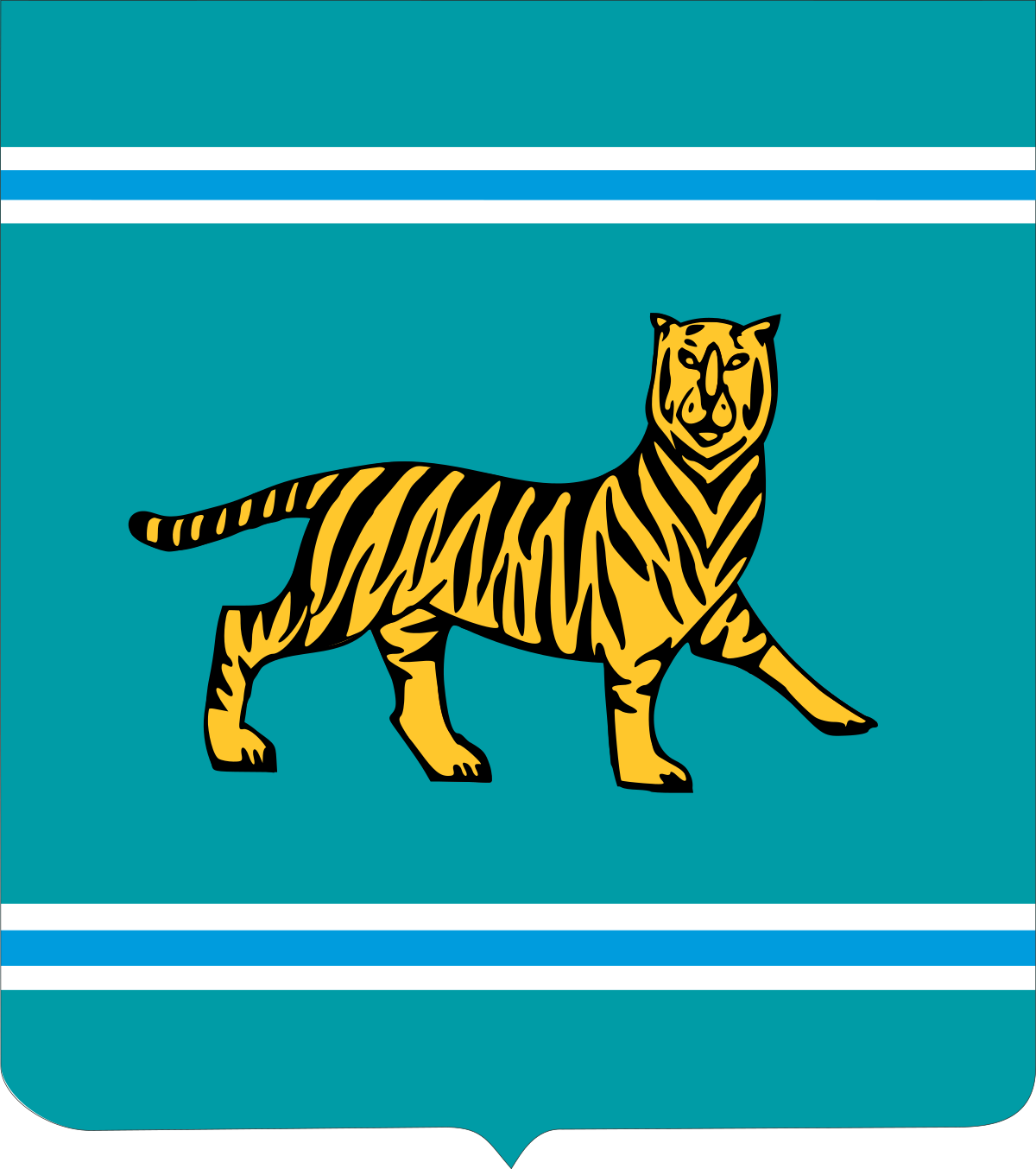
The emblem of the Jewish Autonomous Region is a heraldic French shield (the ratio of width to height is 8:9) of aquamarine color, in the upper and lower parts of which there are narrow horizontal stripes consisting of white, blue and white stripes, equal in width to each other, making up 1/50 height of the emblem, and symbolizing the Bira and Bidzhan rivers. In the center of the emblem there is a golden Ussuri tiger with black stripes according to its natural color. The figure of the tiger is turned to the right of the viewer, which indicates an unusual history and a peculiar way of development of the region.
The tiger symbolizes self-reliance and independence.
I did not find any information about the emblem of the Jewish Autonomous Region in Soviet times.
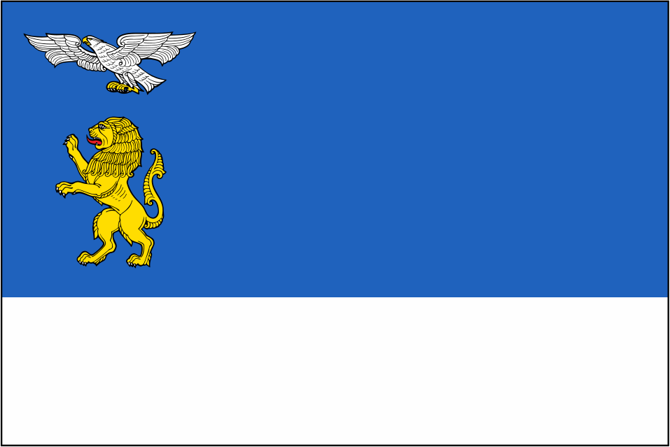
I show you a flag of the Jewish Autonomous Region.

The emblem of Birobidzhan (Биробиджан).
The main city of the Jewish Autonomous Region is Birobidzhan.
It was founded in 1912 and received city status in 1937.
It is a stopping point on the Trans-Siberian Railway, (75 km from the border with China). The name of Birobidzhan consists of the names of the two largest rivers of the Jewish Autonomous Region - Bira and Bidzhan. Birobidzhan stands on the banks of the Bira River. The Bidzhan River flows parallel to the Bira to the west of the city (about 100 km) and flows into the Amur River, as well as the Bira River.
The population of the city is 68,823 (2022).
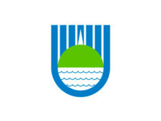
In the azure shield, under six thin silver pillars, there is a green hill, above which there is a thin silver spire. In the silver semicircle, bordered below and on the sides with azure, there are three thin scaly curved azure belts.
The emblem of the city of Birobidzhan forms a stylized image of the menorah [menorah is originally the name for the seven-branched candelabra used in Jewish worship] in combination with the hill and the river Bira, which express the characteristic features of the city.
The emblem of the Jewish Autonomous Region (Еврейская автономная область)
This is the only subject of the federation with the status of the autonomous region.
Due to the fact that the Jews did not have their own state, the RSFSR decided to give them land.
On May 7, 1934, this land received this status, but the land itself was allocated to Jews earlier in 1928.
Here's what they got.
The region is located on the border with China.
It is an area of 36,271 square kilometers (Israel has an area of 22,072 square kilometers).
The population of the region is 153,831 (2022).
Jews have never made up the majority of the population in this area. Their largest number was in 1948, it was equal to 28 thousand. Now Jews make up about 1% of the population there.
The emblem of the Jewish Autonomous Region is a heraldic French shield (the ratio of width to height is 8:9) of aquamarine color, in the upper and lower parts of which there are narrow horizontal stripes consisting of white, blue and white stripes, equal in width to each other, making up 1/50 height of the emblem, and symbolizing the Bira and Bidzhan rivers. In the center of the emblem there is a golden Ussuri tiger with black stripes according to its natural color. The figure of the tiger is turned to the right of the viewer, which indicates an unusual history and a peculiar way of development of the region.
The tiger symbolizes self-reliance and independence.
I did not find any information about the emblem of the Jewish Autonomous Region in Soviet times.
I show you a flag of the Jewish Autonomous Region.
The emblem of Birobidzhan (Биробиджан).
The main city of the Jewish Autonomous Region is Birobidzhan.
It was founded in 1912 and received city status in 1937.
It is a stopping point on the Trans-Siberian Railway, (75 km from the border with China). The name of Birobidzhan consists of the names of the two largest rivers of the Jewish Autonomous Region - Bira and Bidzhan. Birobidzhan stands on the banks of the Bira River. The Bidzhan River flows parallel to the Bira to the west of the city (about 100 km) and flows into the Amur River, as well as the Bira River.
The population of the city is 68,823 (2022).
In the azure shield, under six thin silver pillars, there is a green hill, above which there is a thin silver spire. In the silver semicircle, bordered below and on the sides with azure, there are three thin scaly curved azure belts.
The emblem of the city of Birobidzhan forms a stylized image of the menorah [menorah is originally the name for the seven-branched candelabra used in Jewish worship] in combination with the hill and the river Bira, which express the characteristic features of the city.
I start talking about the regions of Russia.
The emblem of the Amur region (Амурская область)
The Amur is the world's tenth longest river, forming the border between the Russian Far East and Northeastern China (Inner Manchuria). The Amur proper is 2,824 kilometres (1,755 mi) long, and has a drainage basin of 1,855,000 square kilometres (716,000 sq mi).
The region is located on the border with China.
It is an area of 361,908 square kilometers (this is slightly larger than the area of Germany).
The population of the region is 772,525 (2022).
The region was established in 1858. It has existed in its present form since 1948.
The climate of the Amur Region is transitional from sharply continental in the northwest to monsoonal in the southeast.
The emblem of the Amur Region is a green heraldic shield with a silver wavy belt, accompanied at the top of the shield by three gold stars with eight rays. Above the shield is an ancient royal crown and it is surrounded by a ribbon of the Order of Lenin.
The green heraldic shield, established in Russia since the 15th century, symbolizes military prowess, heroism and courage. The green color of the shield is a symbol of abundance and expresses the agricultural character of the region. On top of the shield is the "Ancient Tsar's Crown" - this is a symbol of the state unity of Russia, of which the Amur Region is an integral part.
The wavy silver belt is a symbol of the riverine position of the territory of the region.
Three golden eight-pointed stars on the upper part of the shield express the continuity of the traditions of the historical events of the 17th century, when brave Russian explorers settled of Albazin fortress. The stars personified fidelity to the Orthodox faith, as a symbol of the Mother of God, the Holy Trinity and the Annunciation.
On February 4, 1967, the Amur Region was awarded the Order of Lenin for the successes achieved in economic and cultural construction.
The emblem of the Amur region (1878)
The frame of oak leaves expresses not only the idea of strength and toughness, but also means that oak forest grows in abundance on the Amur hills.
The flag of the Amur region

The main city of the Amur Region is Blagoveshchensk (Благовещенск)
The name comes from two words good (благой) and news (весть). Благовещенье as a church holiday corresponds in the Western church tradition to the Annunciation (the Christian celebration of the announcement by the angel Gabriel to Mary that she would conceive and bear a son through a virgin birth and become the mother of Jesus Christ, the Christian Messiah and Son of God).
It was founded in 1856 as the Ust-Zeya military post on the Amur; in 1858 it was transformed into the city of Blagoveshchensk (according to the church founded in the same year in the name of the Annunciation of the Blessed Virgin Mary).
This is the only administrative center of the region of Russia, located on the state border. At a distance of 526 meters on the right bank of the Amur is the Aihui district of the Chinese urban district of Heihe.
The population of the city is 225,757 (2021).
This is the current and pre-revolutionary emblem of the city of Blagoveshchensk
The flag of the city of Blagoveshchensk
The emblem of the Amur region (Амурская область)
The Amur is the world's tenth longest river, forming the border between the Russian Far East and Northeastern China (Inner Manchuria). The Amur proper is 2,824 kilometres (1,755 mi) long, and has a drainage basin of 1,855,000 square kilometres (716,000 sq mi).
The region is located on the border with China.
It is an area of 361,908 square kilometers (this is slightly larger than the area of Germany).
The population of the region is 772,525 (2022).
The region was established in 1858. It has existed in its present form since 1948.
The climate of the Amur Region is transitional from sharply continental in the northwest to monsoonal in the southeast.
The emblem of the Amur Region is a green heraldic shield with a silver wavy belt, accompanied at the top of the shield by three gold stars with eight rays. Above the shield is an ancient royal crown and it is surrounded by a ribbon of the Order of Lenin.
The green heraldic shield, established in Russia since the 15th century, symbolizes military prowess, heroism and courage. The green color of the shield is a symbol of abundance and expresses the agricultural character of the region. On top of the shield is the "Ancient Tsar's Crown" - this is a symbol of the state unity of Russia, of which the Amur Region is an integral part.
The wavy silver belt is a symbol of the riverine position of the territory of the region.
Three golden eight-pointed stars on the upper part of the shield express the continuity of the traditions of the historical events of the 17th century, when brave Russian explorers settled of Albazin fortress. The stars personified fidelity to the Orthodox faith, as a symbol of the Mother of God, the Holy Trinity and the Annunciation.
On February 4, 1967, the Amur Region was awarded the Order of Lenin for the successes achieved in economic and cultural construction.
The emblem of the Amur region (1878)
The frame of oak leaves expresses not only the idea of strength and toughness, but also means that oak forest grows in abundance on the Amur hills.
The flag of the Amur region
The main city of the Amur Region is Blagoveshchensk (Благовещенск)
The name comes from two words good (благой) and news (весть). Благовещенье as a church holiday corresponds in the Western church tradition to the Annunciation (the Christian celebration of the announcement by the angel Gabriel to Mary that she would conceive and bear a son through a virgin birth and become the mother of Jesus Christ, the Christian Messiah and Son of God).
It was founded in 1856 as the Ust-Zeya military post on the Amur; in 1858 it was transformed into the city of Blagoveshchensk (according to the church founded in the same year in the name of the Annunciation of the Blessed Virgin Mary).
This is the only administrative center of the region of Russia, located on the state border. At a distance of 526 meters on the right bank of the Amur is the Aihui district of the Chinese urban district of Heihe.
The population of the city is 225,757 (2021).
This is the current and pre-revolutionary emblem of the city of Blagoveshchensk
The flag of the city of Blagoveshchensk
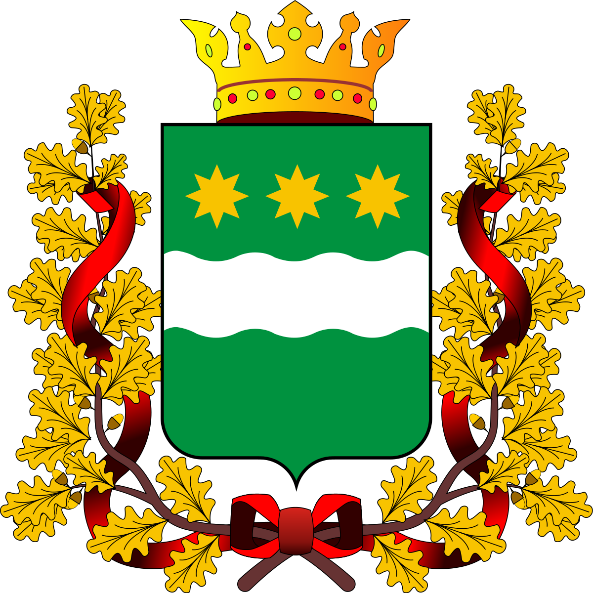
The emblem of the Arkhangelsk region (Архангельская область)
The name of the region comes from the word Archangel (Архангел).
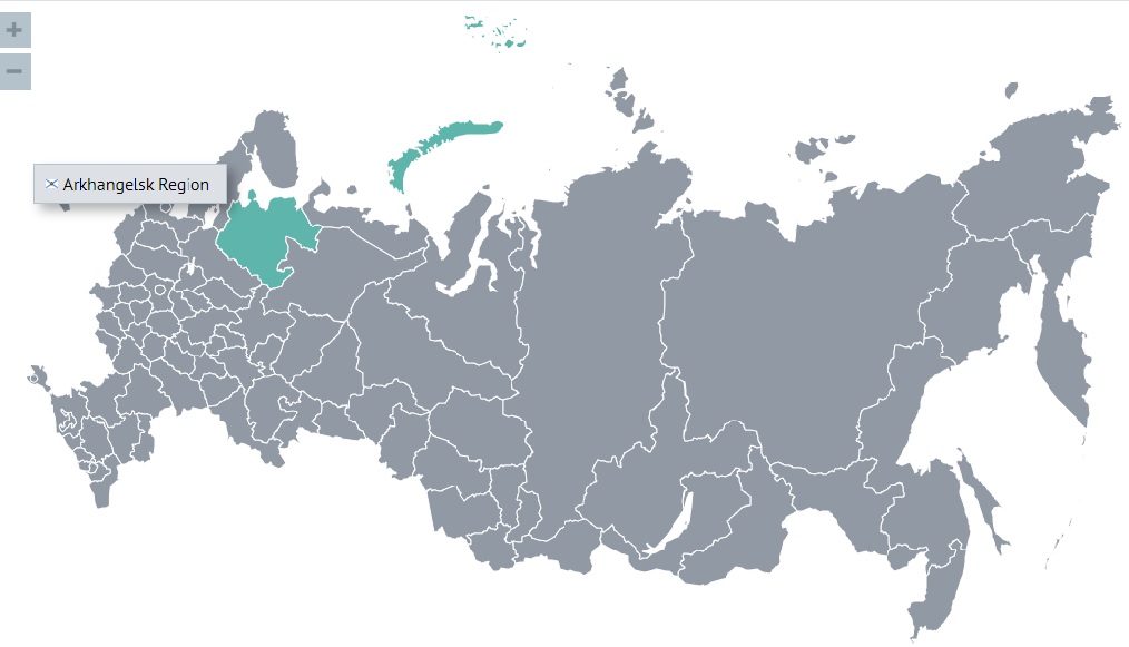
The region is located in the north of the East European Plain. Its shores are washed by the White, Barents, and Kara Seas. The Arkhangelsk region is located close to the Arctic seas and far from the warm North Atlantic current.
It is an area of 589,913 square kilometers (this is somewhat larger than the area of the island of Madagascar and more of the largest European countries).
The population of the region is 1,114,322 (2022).
The first Russians came to the region in the X century. The region has existed in its present form since 1937.
The climate of the region is temperate continental, in the northwest - maritime, in the northeast - subarctic. Characterized by cool summers and long cold winters, frequent changes of air masses coming from the Arctic and middle latitudes. The weather is extremely unstable. The Franz Josef Land and Novaya Zemlya archipelagos, which are part of the region, have an arctic climate.
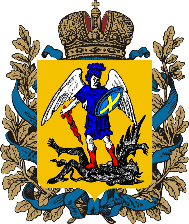
The emblem of the Arkhangelsk region is a quadrangular, with rounded lower corners, a golden shield pointed at the tip. In the golden shield is the Holy Archangel Michael in blue armor and in red boots, holding a red flaming sword with the tip down and an azure shield, which is decorated with a golden cross and has an azure border. He tramples on a black angel of darkness with his head turned to the left. Above the shield is the imperial crown and it is surrounded by golden oak leaves connected by St. Andrew's ribbon.
The regional law on the emblem establishes the official interpretation of the main elements of the coat of arms of the Arkhangelsk region: Archangel Michael is the leader of the heavenly host, the heavenly patron of the Arkhangelsk region; the angel of darkness is the author of sin, seduction, enmity; golden color symbolizes holiness, abundance, power, generosity; red symbolizes power and courage; blue color is a symbol of beauty, softness, greatness; the imperial crown is a heraldic sign of high dignity and power. The imperial crown symbolizes the historical state territorial status of the Arkhangelsk region; golden oak leaves are a sign of military prowess; St. Andrew's Ribbon is the sash of the highest order of the Russian Federation.
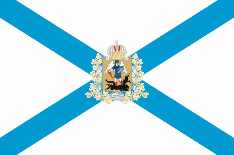
The flag of the Arkhangelsk region
The main city of the Arkhangelsk Region is Arkhangelsk (Архангельск)
The Archangel Michael Monastery on Cape Pur-Navolok was first mentioned in chronicles in 1419, when it was devastated by the Norwegians.
In 1553, the Englishman Richard Chancellor sailed along the White Sea to the village of Nyonoksa on the Summer Coast, and then to the Nikolo-Korelsky Monastery on Yagry Island (now the territory of the city of Severodvinsk). Since that time, trade with the British and Dutch at the mouth of the Northern Dvina began to develop rapidly.
The city was founded in 1584 by decree of Ivan the Terrible as a fortress near the Archangel Michael Monastery. The resulting settlement was named Novokholmogory (Новохолмогоры - Ново- from the word new - новый). Opposite the fortress, on the Dvina coast, a ship pier was built.
Before the founding of St. Petersburg, it was the only port in Russia, which, moreover, stood on the shores of the freezing sea. There were Tatars on the shores of the Caspian Sea. There were Crimean Tatars on the shores of the Azov and Black Seas. On the shores of the Baltic Sea were Danes, Swedes and the Livonian division of the Knights of the Teutonic Order.
From the end of the 80s of the 16th century, the settlement of Novokholmogory became the center of Russian foreign trade, bringing in up to 61% of the income of the state treasury. On March 26, 1596, the new city on the Dvina was first named the Arkhangelsk city after the monastery located in it, and on August 1, 1613, this name was approved in connection with the official decision on the administrative independence of the city of Arkhangelsk from Kholmogory.
The population of the city is 344,927 (2021).
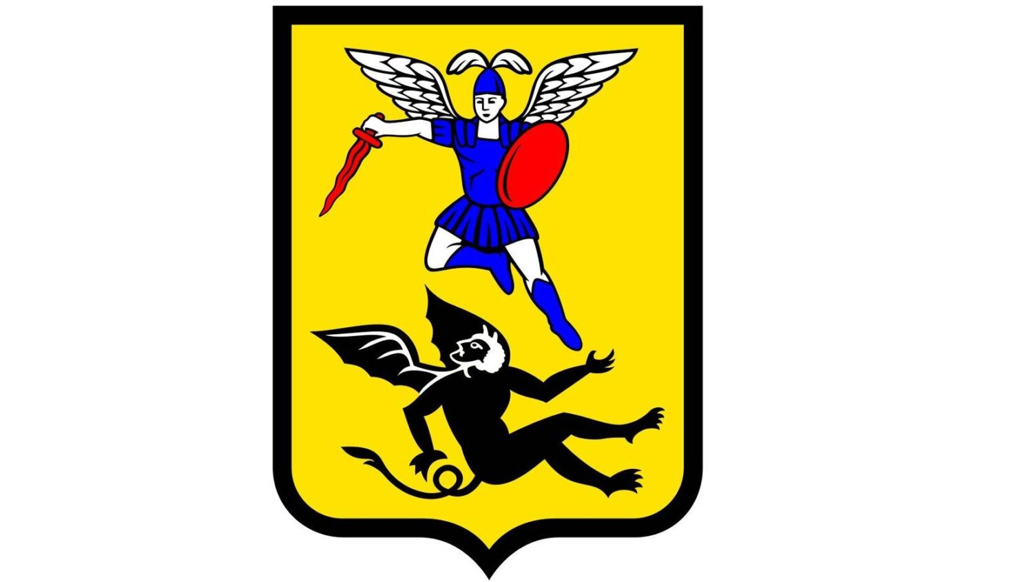
In the golden background of the shield, a flying archangel in a blue robe with a fiery sword and shield is depicted, defeating the black devil.
The flying archangel in a blue robe with a fiery sword and shield symbolizes the Russian army, the victory of the forces of good over the forces of evil. The black devil personifies the enemy, the evil that will be defeated.
The name of the region comes from the word Archangel (Архангел).
The region is located in the north of the East European Plain. Its shores are washed by the White, Barents, and Kara Seas. The Arkhangelsk region is located close to the Arctic seas and far from the warm North Atlantic current.
It is an area of 589,913 square kilometers (this is somewhat larger than the area of the island of Madagascar and more of the largest European countries).
The population of the region is 1,114,322 (2022).
The first Russians came to the region in the X century. The region has existed in its present form since 1937.
The climate of the region is temperate continental, in the northwest - maritime, in the northeast - subarctic. Characterized by cool summers and long cold winters, frequent changes of air masses coming from the Arctic and middle latitudes. The weather is extremely unstable. The Franz Josef Land and Novaya Zemlya archipelagos, which are part of the region, have an arctic climate.
The emblem of the Arkhangelsk region is a quadrangular, with rounded lower corners, a golden shield pointed at the tip. In the golden shield is the Holy Archangel Michael in blue armor and in red boots, holding a red flaming sword with the tip down and an azure shield, which is decorated with a golden cross and has an azure border. He tramples on a black angel of darkness with his head turned to the left. Above the shield is the imperial crown and it is surrounded by golden oak leaves connected by St. Andrew's ribbon.
The regional law on the emblem establishes the official interpretation of the main elements of the coat of arms of the Arkhangelsk region: Archangel Michael is the leader of the heavenly host, the heavenly patron of the Arkhangelsk region; the angel of darkness is the author of sin, seduction, enmity; golden color symbolizes holiness, abundance, power, generosity; red symbolizes power and courage; blue color is a symbol of beauty, softness, greatness; the imperial crown is a heraldic sign of high dignity and power. The imperial crown symbolizes the historical state territorial status of the Arkhangelsk region; golden oak leaves are a sign of military prowess; St. Andrew's Ribbon is the sash of the highest order of the Russian Federation.
The flag of the Arkhangelsk region
The main city of the Arkhangelsk Region is Arkhangelsk (Архангельск)
The Archangel Michael Monastery on Cape Pur-Navolok was first mentioned in chronicles in 1419, when it was devastated by the Norwegians.
In 1553, the Englishman Richard Chancellor sailed along the White Sea to the village of Nyonoksa on the Summer Coast, and then to the Nikolo-Korelsky Monastery on Yagry Island (now the territory of the city of Severodvinsk). Since that time, trade with the British and Dutch at the mouth of the Northern Dvina began to develop rapidly.
The city was founded in 1584 by decree of Ivan the Terrible as a fortress near the Archangel Michael Monastery. The resulting settlement was named Novokholmogory (Новохолмогоры - Ново- from the word new - новый). Opposite the fortress, on the Dvina coast, a ship pier was built.
Before the founding of St. Petersburg, it was the only port in Russia, which, moreover, stood on the shores of the freezing sea. There were Tatars on the shores of the Caspian Sea. There were Crimean Tatars on the shores of the Azov and Black Seas. On the shores of the Baltic Sea were Danes, Swedes and the Livonian division of the Knights of the Teutonic Order.
From the end of the 80s of the 16th century, the settlement of Novokholmogory became the center of Russian foreign trade, bringing in up to 61% of the income of the state treasury. On March 26, 1596, the new city on the Dvina was first named the Arkhangelsk city after the monastery located in it, and on August 1, 1613, this name was approved in connection with the official decision on the administrative independence of the city of Arkhangelsk from Kholmogory.
The population of the city is 344,927 (2021).
In the golden background of the shield, a flying archangel in a blue robe with a fiery sword and shield is depicted, defeating the black devil.
The flying archangel in a blue robe with a fiery sword and shield symbolizes the Russian army, the victory of the forces of good over the forces of evil. The black devil personifies the enemy, the evil that will be defeated.
edit on 4 27 2022 by turretless because: (no reason given)
The emblem of the Astrakhan region (Астраханская область)
The Astrakhan region is located in the southeast of the East European Plain within the Caspian lowland, in temperate latitudes, in the zone of deserts and semi-deserts, which are used mainly as pastures.
From the east, the Astrakhan region borders on Kazakhstan. It is located on the shore of the Caspian Sea. (There are five states on the shores of the Caspian Sea: Kazakhstan, Iran, Turkmenistan, Russia and Azerbaijan.)
It is an area of 49,024 square kilometers (this is slightly more than the territory of Slovakia and slightly less than the territory of Costa Rica).
The population of the region is 989,430 (2022).
In 1554, Astrakhan was taken by the troops of Ivan IV the Terrible. It was finally annexed in 1556.
The region has repeatedly become the scene of anti-government uprisings, for example, the uprising of Stepan Razin (1667-1671).
The region has existed in its modern form since 1943.
The climate of the Astrakhan region is continental, dry. The winter is not snowy, in most of the region there is a noticeable strong softening influence of the Caspian Sea, with frequent thaws and unstable snow cover, however, on some days there are quite intense frosts when cold air masses invade from Kazakhstan or the Urals. Hot summer. The climate is also characterized by large annual and daily amplitudes of air temperature, low precipitation and high evaporation of moisture.
The emblem of the Astrakhan region is a blue heraldic shield, on which a golden crown and a silver sword are depicted. Above the shield is the royal crown - the Astrakhan cap.
The crown, introduced by the Russian Astrakhan governors in stamp, meant the annexation of the Astrakhan Khanate to Russia in 1556. At that time, Astrakhan was one of the border fortresses of the Russian state, guarding the mouth of the Volga River. The naked saber, later replaced by a sword, symbolized the protection of the crown, the protection of borderlands on the southern outskirts of the country. The eastern sword said where the danger for Russia came from and against which enemies it was directed. The Astrakhan cap, or crown, located above the shield, was made for Tsar Mikhail Fedorovich - the first representative of the Romanov dynasty in 1627. The cap symbolized that the territory of the Astrakhan Khanate was not Russian from time immemorial, but was annexed to the Russian state at a certain time. The Astrakhan cap is stored in the Armory of the Moscow Kremlin. The blue color of the background of the emblem speaks of one territorial and geographical feature of the region - its location in the lower reaches of the Volga River.
The flag of the Astrakhan region
The main city of the Astrakhan Region is Astrakhan (Астрахань)
The city is located in the upper part of the Volga River delta, on 11 islands of the Caspian lowland.
For almost three centuries, Astrakhan was the main administrative center through which trade and political relations of the Russian state with the countries of the East, Transcaucasia and the North Caucasus were carried out.
Being at the crossroads of caravan and water routes, Astrakhan in the 17th-18th centuries turned from a small fortified fortress in the south of the Russian state into a large trade and craft city, and the Volga River became the most important transport artery of the country.
In the first quarter of the 18th century, a strong navy, an admiralty, shipyards, and a port were created in Astrakhan.
In the 1860s, due to the development of oil fields in Baku (Azerbaijan), the port of Astrakhan became one of the largest in the country. In 1873, the world's first oil tanker appeared in the Caspian. It was created by the Astrakhan shipowners, the Artemiev brothers, pouring oil for transportation directly into the hold of their Alexander sailboat. This technical solution was used by the Swedish industrialists, the Nobel brothers, who had their own factories in Astrakhan and were engaged in oil development in the Caspian Sea. Two years later, they built the world's first steam tanker.
During the civil war, Astrakhan became of key importance, which caused fierce battles between the opposing sides for the capture of the city.
In the summer of 1942, the Nazi troops approached Astrakhan at a distance of 100-150 km. There was no continuous front line; a war of maneuver was waged in the steppe. The Luftwaffe bombed the riverboats on the Volga, several bombs fell on the city.
The population of the city is 524,371 (2021).
The flag of the Astrakhan
I love this thread. Very cool subject matter and you present it well. Do you speak English or do you use translator software for posting?
originally posted by: GAOTU789
I love this thread. Very cool subject matter and you present it well. Do you speak English or do you use translator software for posting?
Thank you!
I studied English at school. So I have some basic knowledge of English.
I use an auto-translator to write posts, but I check what it wrote in accordance with my knowledge of English.
I usually understand the general meaning of what is written in English text.
When I listen to English speech, I often cannot understand what is being said.
Glad to see you have added material to your thread. I am fascinated by Russian history so it is most welcome. Arkhangelsk may be familiar to those who
studied WW2 as it was one of the only ports open to take Lend-lease supplies to Russia. It was the most perilous voyage to take as German submarines
and the battleship Tirpitz took a heavy toll of merchant vessels en route. I think it was PQ37 that lost 20 or more ships in a single convoy. Few
survived any sinking vessels in the Arctic waters.
The Astrakhan crown is familiar to me as it reflects the traditional headwear of the area. Astrakhan Cossacks wore that distinctive bell-shaped hat during the Napoleonic campaigns against France, armed mainly with lances and bows.
The scimitar in the flag represents possession being taken from the various Khanates of mixed Muslim/Mongol ancestry. Those were the empires left in the wake of the mongol invasions.
edit on 30-4-2022 by Asktheanimals because: (no reason given)
edit on 30-4-2022 by
Asktheanimals because: (no reason given)
originally posted by: Asktheanimals
Glad to see you have added material to your thread. I am fascinated by Russian history so it is most welcome. Arkhangelsk may be familiar to those who studied WW2 as it was one of the only ports open to take Lend-lease supplies to Russia. It was the most perilous voyage to take as German submarines and the battleship Tirpitz took a heavy toll of merchant vessels en route. I think it was PQ37 that lost 20 or more ships in a single convoy. Few survived any sinking vessels in the Arctic waters.
The Astrakhan crown is familiar to me as it reflects the traditional headwear of the area. Astrakhan Cossacks wore that distinctive bell-shaped hat during the Napoleonic campaigns against France, armed mainly with lances and bows.
The scimitar in the flag represents possession being taken from the various Khanates of mixed Muslim/Mongol ancestry. Those were the empires left in the wake of the mongol invasions.
Thank you!
I see that you know some details of Russian history better than I do.
In fact, I didn’t know before how the emblems of the cities (I made posts about) look like. With the exception of Zelenograd and Moscow.
Usually this happens if you tell something to other people, then you yourself will learn a lot of new things (due to the fact that you have to delve deeply into the subject).
The emblem of the Belgorod region (Белгородская область)
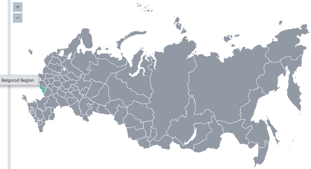
In the south and west, it borders on the Luhansk People's Republic, Kharkiv and Sumy regions of Ukraine.
It is an area of 27,134 square kilometers (its area is approximately equal to the area of the Republic of Haiti).
The population of the region is 1,531,917 (2022).
In the VIII-IX centuries, this territory fell under the rule of Khazaria. During the years of Kievan Rus', it was part of the Chernigov Principality.
The Mongol-Tatar invasion led to the desolation of the region. Chronicle sources of the 14th-15th centuries report the presence on the territory of the modern region of the cities of Khotmyshl and Oskol, which were restored by the Grand Duchy of Lithuania after the Mongol-Tatar devastation. Which testifies to the development of the Belgorod region by the Grand Duchy of Lithuania. Since 1500 it has been part of the Grand Duchy of Moscow [in the original, the words "Великое княжество" are used here, which should perhaps be translated as a kingdom, since there were no overlords over the Grand Duke "Великий князь"].
At the turn of the 16th-17th centuries, for the reliable protection of Russian possessions, a continuous line of military fortifications was built - the Belgorod defensive line, which stretched for almost 800 kilometers. Having emerged as an outpost on the southern borders of Russia, the Belgorod region has inscribed many remarkable heroic pages into its history.
During the Great Patriotic War, the famous Prokhorovka tank battle took place on Belgorod land, which became the starting point of the Victory over Nazi Germany.
In 1708-1727, the territory of the modern Belgorod region was part of the Kyiv and Azov provinces. In 1727, the Belgorod province was formed, which lasted until 1779. It occupied the lands not only of the modern Belgorod region, but also the territories of the current Kursk, Oryol, partially Bryansk and Kharkov regions.
In 1775-1779, the territory of the Belgorod province was divided between the newly formed provinces and governorships, and the province itself was abolished. Belgorod region, including the city of Belgorod, became part of the Kursk governorate.
After the signing of the Treaty of Brest-Litovsk, from April 1918 to January 1919, the Belgorod region was an integral part of the Ukrainian state of Hetman P. Skoropadsky.
Until 1928, the territory of the modern Belgorod region was part of the Voronezh and Kursk provinces.
The region has existed in its modern form since 1954.
The climate is temperate, temperate continental, with rather mild winters with snowfalls and thaws and long summers. The average annual air temperature varies from +5.4 degrees in the north to +6.8 degrees in the southeast.
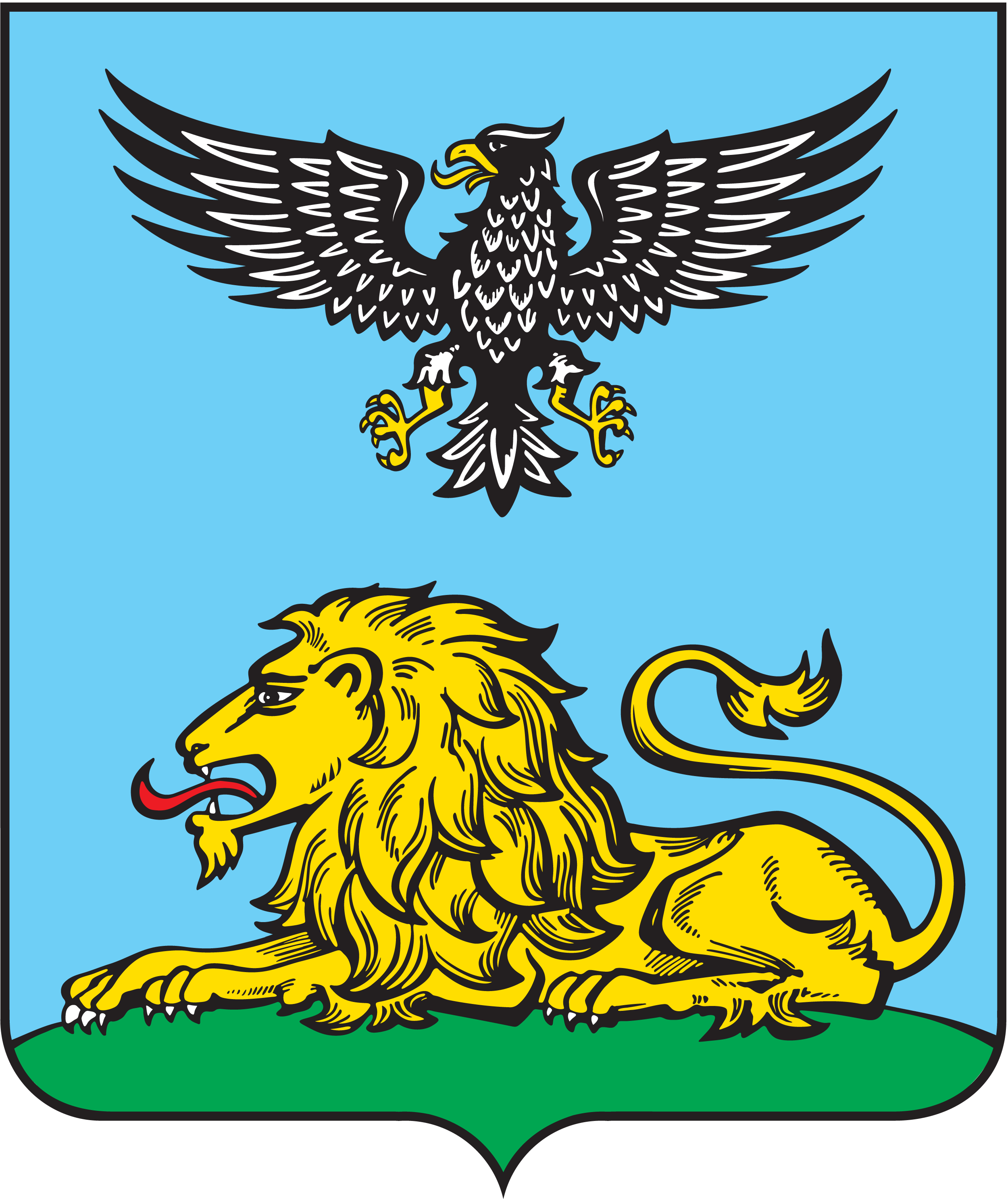
Against an azure background, a black eagle with silver eyes and a golden beak, tongue and claws. It hovers over a golden lion with silver eyes, teeth and claws and a red tongue lying on the green ground.
Placement on the heraldic shield of the emblem of a golden lion and a single-headed eagle above it is associated with a specific historical event: the worthy participation of the Belgorod people in the Belgorod army field regiment in the Northern War of 1700-1721 and the especially shown courage of the Belgorod infantrymen (fuselers and grenadiers) in the Battle of Poltava 27 June 1709, which ended in the complete defeat of the Swedes.
The lion in the Belgorod emblem represents defeated Sweden (the image of the lion was on the royal banner of Charles XII, and the eagle was depicted on the banner of the leader of the Russian troops - Tsar Peter the Great).
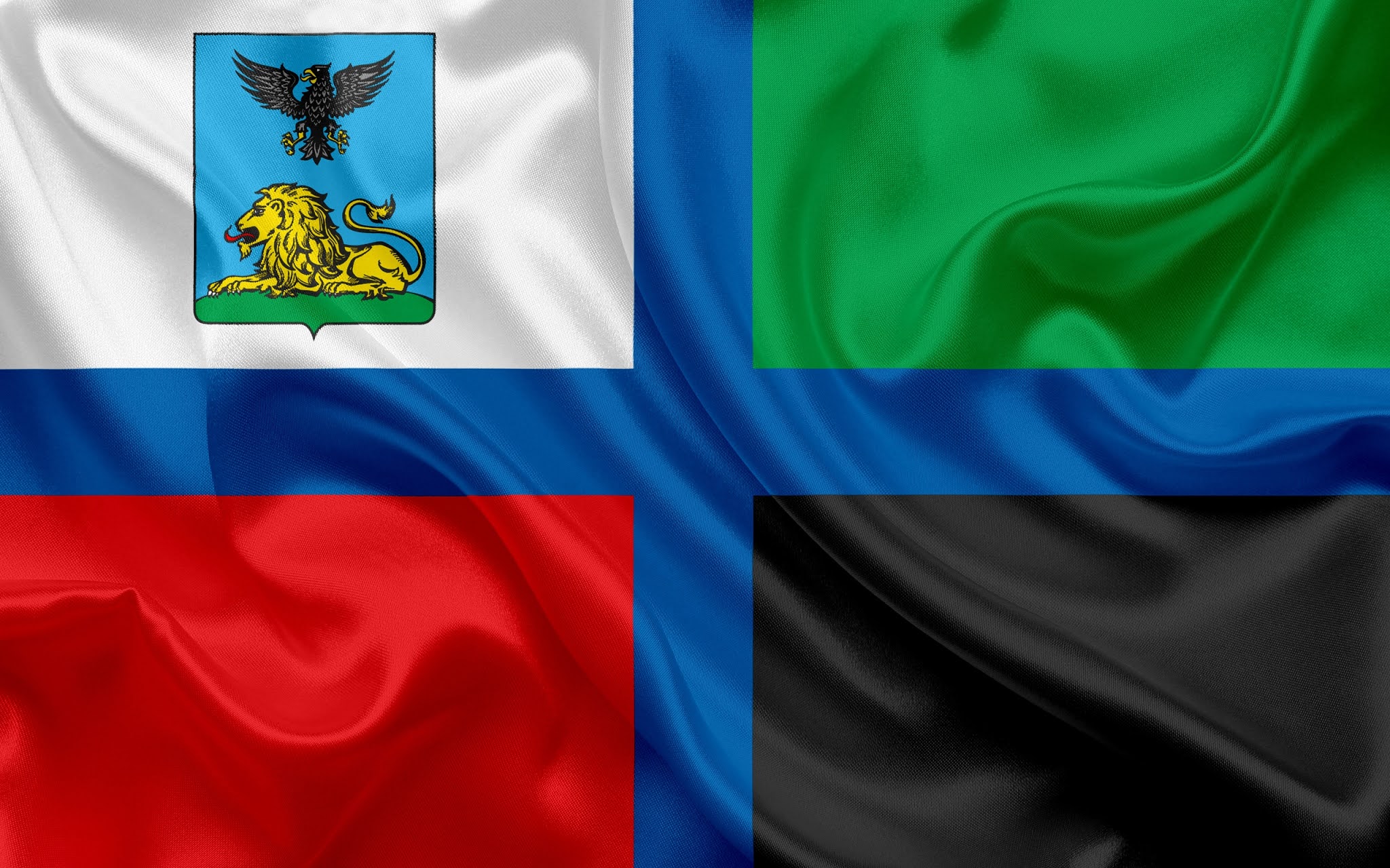
The flag of the Belgorod region
The main city of the Belgorod Region is Belgorod (Белгород)
The name of the city consists of two words white (белый) and town (город). As far as I understand the name of the Serbian capital Belgrade is its exact analogue.
The city is located on the southern outskirts of the Central Russian Upland, on the banks of the Belgorod reservoir, the Vezelka and Seversky Donets rivers, 700 km south of Moscow, 40 km from the border with Ukraine.
According to the point of view accepted by most local historians, for the first time the city of Belgorod was founded by decree of Tsar Fyodor Ioannovich on September 11, 1596, as a border fortress.
However, in 1995 the city authorities celebrated the 1000th anniversary of the city. This date was determined on the basis of research by the local historian Y. Shmelev.
Disputes about the founding of Belgorod in the 10th century have been going on since the middle of the 19th century. A scientific study of the history of Belgorod in the 10th-15th centuries has not yet been carried out.
In 1612, the fortress was taken, plundered and burned by the Polish-Lithuanian army.
At the beginning of the 18th century, after the annexation of the Novorossia Territory to Russia and the construction of the Ukrainian defensive line, the strategic importance of Belgorod decreased significantly.
With the construction of the railways Kursk-Kharkov, Belgorod-Volchansk and Belgorod-Sumy, the city's ties with industrial centers and neighboring counties expanded. Belgorod entered the 20th century as a major railway point.
Soviet power in the city was established on October 26, 1917.
April 11, 1918 Belgorod was occupied by German troops.
During the Great Patriotic War, bloody battles took place in the vicinity of Belgorod. The city was twice occupied by the Germans - from October 24, 1941 to February 9, 1943 and from March 18 to August 5, 1943.
During the war years, the city was severely destroyed, almost all of the historical buildings of the city perished, only a few dozen buildings survived.
The population of the city is 391,702 (2021).
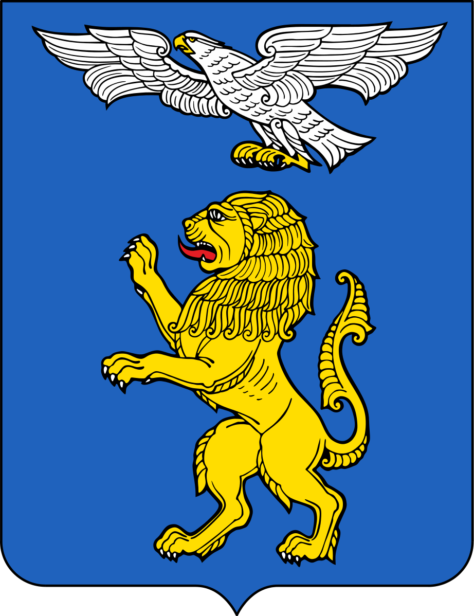
Against a blue background, a rising golden lion with a red tongue and silver eyes, teeth and claws; above it, a silver eagle flying to the left with outstretched wings with golden eyes, tongue, beak, claws and paws.
The Soviet emblem of Belgorod (1970)
In the silver shield is a small central blue shield with a soaring eagle and a golden lion lying on the green ground. The shield is framed by oak branches intertwined with a guards ribbon. Around them is half a gear, blue and red, continued with golden ears of wheat. Above the shield is a golden city crown with three prongs.
The emblem of Belgorod (1893)
In a blue shield, a golden lion with red eyes and a tongue, accompanied from above by a soaring silver eagle with a golden beak, eyes and claws; in the free part is the emblem of the Kursk province. Above the shield is a silver crown with three teeth. Behind the shield are two gold hammers placed crosswise, connected by an Alexander ribbon.
The flag of the Belgorod
In the south and west, it borders on the Luhansk People's Republic, Kharkiv and Sumy regions of Ukraine.
It is an area of 27,134 square kilometers (its area is approximately equal to the area of the Republic of Haiti).
The population of the region is 1,531,917 (2022).
In the VIII-IX centuries, this territory fell under the rule of Khazaria. During the years of Kievan Rus', it was part of the Chernigov Principality.
The Mongol-Tatar invasion led to the desolation of the region. Chronicle sources of the 14th-15th centuries report the presence on the territory of the modern region of the cities of Khotmyshl and Oskol, which were restored by the Grand Duchy of Lithuania after the Mongol-Tatar devastation. Which testifies to the development of the Belgorod region by the Grand Duchy of Lithuania. Since 1500 it has been part of the Grand Duchy of Moscow [in the original, the words "Великое княжество" are used here, which should perhaps be translated as a kingdom, since there were no overlords over the Grand Duke "Великий князь"].
At the turn of the 16th-17th centuries, for the reliable protection of Russian possessions, a continuous line of military fortifications was built - the Belgorod defensive line, which stretched for almost 800 kilometers. Having emerged as an outpost on the southern borders of Russia, the Belgorod region has inscribed many remarkable heroic pages into its history.
During the Great Patriotic War, the famous Prokhorovka tank battle took place on Belgorod land, which became the starting point of the Victory over Nazi Germany.
In 1708-1727, the territory of the modern Belgorod region was part of the Kyiv and Azov provinces. In 1727, the Belgorod province was formed, which lasted until 1779. It occupied the lands not only of the modern Belgorod region, but also the territories of the current Kursk, Oryol, partially Bryansk and Kharkov regions.
In 1775-1779, the territory of the Belgorod province was divided between the newly formed provinces and governorships, and the province itself was abolished. Belgorod region, including the city of Belgorod, became part of the Kursk governorate.
After the signing of the Treaty of Brest-Litovsk, from April 1918 to January 1919, the Belgorod region was an integral part of the Ukrainian state of Hetman P. Skoropadsky.
Until 1928, the territory of the modern Belgorod region was part of the Voronezh and Kursk provinces.
The region has existed in its modern form since 1954.
The climate is temperate, temperate continental, with rather mild winters with snowfalls and thaws and long summers. The average annual air temperature varies from +5.4 degrees in the north to +6.8 degrees in the southeast.
Against an azure background, a black eagle with silver eyes and a golden beak, tongue and claws. It hovers over a golden lion with silver eyes, teeth and claws and a red tongue lying on the green ground.
Placement on the heraldic shield of the emblem of a golden lion and a single-headed eagle above it is associated with a specific historical event: the worthy participation of the Belgorod people in the Belgorod army field regiment in the Northern War of 1700-1721 and the especially shown courage of the Belgorod infantrymen (fuselers and grenadiers) in the Battle of Poltava 27 June 1709, which ended in the complete defeat of the Swedes.
The lion in the Belgorod emblem represents defeated Sweden (the image of the lion was on the royal banner of Charles XII, and the eagle was depicted on the banner of the leader of the Russian troops - Tsar Peter the Great).
The flag of the Belgorod region
The main city of the Belgorod Region is Belgorod (Белгород)
The name of the city consists of two words white (белый) and town (город). As far as I understand the name of the Serbian capital Belgrade is its exact analogue.
The city is located on the southern outskirts of the Central Russian Upland, on the banks of the Belgorod reservoir, the Vezelka and Seversky Donets rivers, 700 km south of Moscow, 40 km from the border with Ukraine.
According to the point of view accepted by most local historians, for the first time the city of Belgorod was founded by decree of Tsar Fyodor Ioannovich on September 11, 1596, as a border fortress.
However, in 1995 the city authorities celebrated the 1000th anniversary of the city. This date was determined on the basis of research by the local historian Y. Shmelev.
Disputes about the founding of Belgorod in the 10th century have been going on since the middle of the 19th century. A scientific study of the history of Belgorod in the 10th-15th centuries has not yet been carried out.
In 1612, the fortress was taken, plundered and burned by the Polish-Lithuanian army.
At the beginning of the 18th century, after the annexation of the Novorossia Territory to Russia and the construction of the Ukrainian defensive line, the strategic importance of Belgorod decreased significantly.
With the construction of the railways Kursk-Kharkov, Belgorod-Volchansk and Belgorod-Sumy, the city's ties with industrial centers and neighboring counties expanded. Belgorod entered the 20th century as a major railway point.
Soviet power in the city was established on October 26, 1917.
April 11, 1918 Belgorod was occupied by German troops.
During the Great Patriotic War, bloody battles took place in the vicinity of Belgorod. The city was twice occupied by the Germans - from October 24, 1941 to February 9, 1943 and from March 18 to August 5, 1943.
During the war years, the city was severely destroyed, almost all of the historical buildings of the city perished, only a few dozen buildings survived.
The population of the city is 391,702 (2021).
Against a blue background, a rising golden lion with a red tongue and silver eyes, teeth and claws; above it, a silver eagle flying to the left with outstretched wings with golden eyes, tongue, beak, claws and paws.
The Soviet emblem of Belgorod (1970)
In the silver shield is a small central blue shield with a soaring eagle and a golden lion lying on the green ground. The shield is framed by oak branches intertwined with a guards ribbon. Around them is half a gear, blue and red, continued with golden ears of wheat. Above the shield is a golden city crown with three prongs.
The emblem of Belgorod (1893)
In a blue shield, a golden lion with red eyes and a tongue, accompanied from above by a soaring silver eagle with a golden beak, eyes and claws; in the free part is the emblem of the Kursk province. Above the shield is a silver crown with three teeth. Behind the shield are two gold hammers placed crosswise, connected by an Alexander ribbon.
The flag of the Belgorod
Much of my fascination is about the Cossacks who were essentially the frontiersmen and militia in the Westward expansion of the US except going East
(and starting 2 centuries prior at least). These were true explorers like Lewis and Clark but largely forgotten by history. They fought their fair
share of unfriendly tribes and dealt with severe weather, illness, mutinies and more. They were primarily sent by the Czar who sought to expand
Eastward in to what was in the 17th century wilderness, much of it still is. There isn't a lot of material about the various Cossack groups but they
did have a strange relationship with Moscow. Military service was mandatory and often 20 years or more. Men were expected to provide their own horses
and armaments. Government would provide gunpowder and a few basic raw materials. Not much of a deal but it did allow them to live in semi-autonomous
collectives. They were also primarily male communities of trappers, hunters, fishermen, traders with occasional bouts of banditry. In times of war the
Czar expected them to show up to fight as irregular troops and they performed their role extremely well. They were also adept at raiding the Black and
Caspian sea towns in small craft called Chaikas. They even took on and defeated the Ottoman navy a few times. One of their missions was to recapture
Russians who had been sold in to slavery in the Ottoman empire. Many were also devout Orthodox Christians which made them a very eccentric mix of
warriors/settlers. Their equestrian skills were learned from the Mongols and in time became probably the world's finest horsemen. All while riding on
poor-looking steppe horses that required little care but could carry their riders for days on end without pause if needed. I could go on but I think
I've shared my passion enough.
Cossacks!
Cossacks!
Interesting thread I really love heraldry and was really interested in it in my teens when I was crazy for medieval history, Living in Scotland I had
an abundance thrust upon my feet to get stuck into and it kept me going for long enough.
Russia like Scotland has a really deep and interesting medieval history the one thing i know that links both nations is that we share the same patron saint .
Saint Andrew
and so we share some heraldry designs the St. Andrews cross and the lion rampant
Russia like Scotland has a really deep and interesting medieval history the one thing i know that links both nations is that we share the same patron saint .
Saint Andrew
and so we share some heraldry designs the St. Andrews cross and the lion rampant
a reply to: Asktheanimals
The appearance of the Cossacks is the answer of Russia and Ukraine to the threat from the steppe and from the Crimea. Note that there are no Cossacks in Novgorod, Pskov, Smolensk where the Russians faced European pressure.
After all, Russia does not have its own Thermopylae; a narrow mountain pass that must be protected so that the enemy does not pass. Once the rivers freeze they are an excellent path for the steppe cavalry.
I have no doubt you know that China had to build the Great Wall of China to solve the same problem. Russia did not have the resources to build such a wall.
Therefore, on the borders with the steppe, communities of free armed people appeared, always ready for an enemy attack.
a reply to: turretless
its mad to think that Russia escaped the whole 30 years war that raged in Europe between protestant and catholics
really bizarre
how the hell did Russia manage to avoid the influence of Rome ?
its mad to think that Russia escaped the whole 30 years war that raged in Europe between protestant and catholics
really bizarre
how the hell did Russia manage to avoid the influence of Rome ?
a reply to: sapien82
It was very simple.
Christianity was accepted by the Russians not from the hands of the Pope, but from the hands of the Patriarch of Constantinople.
In other words, the Russians got it from the Eastern Roman Empire (Byzantium) and not from the Western Roman Empire.
In 1988 (in the USSR) the 1000th anniversary of the baptism of Russia was celebrated.
new topics
-
whistleblower Captain Bill Uhouse on the Kingman UFO recovery
Aliens and UFOs: 2 hours ago -
1980s Arcade
General Chit Chat: 4 hours ago -
Deadpool and Wolverine
Movies: 5 hours ago -
Teenager makes chess history becoming the youngest challenger for the world championship crown
Other Current Events: 6 hours ago -
CIA botched its handling of sexual assault allegations, House intel report says
Breaking Alternative News: 7 hours ago -
Lawsuit Seeks to ‘Ban the Jab’ in Florida
Diseases and Pandemics: 10 hours ago
top topics
-
Lawsuit Seeks to ‘Ban the Jab’ in Florida
Diseases and Pandemics: 10 hours ago, 20 flags -
Starburst galaxy M82 - Webb Vs Hubble
Space Exploration: 12 hours ago, 11 flags -
CIA botched its handling of sexual assault allegations, House intel report says
Breaking Alternative News: 7 hours ago, 8 flags -
The Superstition of Full Moons Filling Hospitals Turns Out To Be True!
Medical Issues & Conspiracies: 13 hours ago, 8 flags -
IDF Intel Chief Resigns Over Hamas attack
Middle East Issues: 17 hours ago, 6 flags -
whistleblower Captain Bill Uhouse on the Kingman UFO recovery
Aliens and UFOs: 2 hours ago, 6 flags -
15 Unhealthiest Sodas On The Market
Health & Wellness: 12 hours ago, 5 flags -
Teenager makes chess history becoming the youngest challenger for the world championship crown
Other Current Events: 6 hours ago, 3 flags -
Deadpool and Wolverine
Movies: 5 hours ago, 3 flags -
1980s Arcade
General Chit Chat: 4 hours ago, 3 flags
active topics
-
1980s Arcade
General Chit Chat • 7 • : Freeborn -
How ageing is" immune deficiency"
Medical Issues & Conspiracies • 24 • : annonentity -
Europe declares war on Russia?
World War Three • 59 • : Freeborn -
George Knapp AMA on DI
Area 51 and other Facilities • 38 • : theshadowknows -
Candidate TRUMP Now Has Crazy Judge JUAN MERCHAN After Him - The Stormy Daniels Hush-Money Case.
Political Conspiracies • 618 • : WeMustCare -
New whistleblower Jason Sands speaks on Twitter Spaces last night.
Aliens and UFOs • 38 • : baablacksheep1 -
-@TH3WH17ERABB17- -Q- ---TIME TO SHOW THE WORLD--- -Part- --44--
Dissecting Disinformation • 605 • : Ektar -
Teenager makes chess history becoming the youngest challenger for the world championship crown
Other Current Events • 3 • : Skinnerbot -
So you don't believe in the devil
Paranormal Studies • 143 • : burritocat -
whistleblower Captain Bill Uhouse on the Kingman UFO recovery
Aliens and UFOs • 5 • : budzprime69