It looks like you're using an Ad Blocker.
Please white-list or disable AboveTopSecret.com in your ad-blocking tool.
Thank you.
Some features of ATS will be disabled while you continue to use an ad-blocker.

The Great Pyramid's 'Phantom Chamber'
page: 3share:
originally posted by: CharlesNPope
a reply to: Hooke
Those 30 items were presented in the previous thread ("Logarithmic Path of the Poles"), which you posted on, but evidently didn't bother to read.
I've looked through the thread (as you didn't bother to post any links), but can't find the thirty items.
originally posted by: CharlesNPope
a reply to: Hooke
Yes, I know you don't think there is any evidence ...
2. The key dimensions and geodetic location of the Great Pyramid
Encodes knowledge not possessed in the 4th Dynasty.
I see now that you're referring to Marco Vigato, 15 Reasons.
With reference to Vigato's The key dimensions and geodetic location of the Great Pyramid , (2: 4-5), I would point out that the supposed significance of the Great Pyramid's location at the supposed "centre of the landmass" has been examined in detail and found to be without foundation.
The proposal that its dimensions supposedly encode key geodetic measurements (mentioning the conclusions of Stecchini) has equally been examined and found wanting (scroll down to "Greek geographers.")
a reply to: CharlesNPope
From: www.abovetopsecret.com...
The statement regarding Manetho and Africanus appears to be incorrect.
But this text (Fragments of Manetho) is Fr. 15 (from Syncellus). According to Eusebius
Not Africanus.
From: www.abovetopsecret.com...
5. Manetho – First Dynasty Pyramids?
Manetho ascribes thousands of years between the time of the gods and the first dynasty of Egypt. The Syncellus version of Manetho stated that during a drought Uenephês/Ouenephes was the first (dynastic) king to build pyramids. If he is the early pharaoh Anedjib, then he failed at building his own personal pyramid. Only the Africanus version of Manetho includes the annotation that Souphis built the Great Pyramid and is the same as the Khufu spoken of by Herodotus.
The statement regarding Manetho and Africanus appears to be incorrect.
The Fourth Dynasty comprised seventeen kings of Memphis belonging to a different royal line.
Of these the third was Suphis, the builder of the Great Pyramid, which Herodotus says was built by Cheops. Suphis conceived a contempt for the gods, but repenting of this, he composed the Sacred Book, which the Egyptians hold in high esteem.
But this text (Fragments of Manetho) is Fr. 15 (from Syncellus). According to Eusebius
Not Africanus.
edit on 17-3-2022 by Hooke because: correct link
originally posted by: Scott Creighton
The AE priest Manetho names 'Suphis' as the builder of the GP.
Notice how the Greek spelling of Suphis (Σοūφις) and Saurid (Σοūριδ) are very similar and if we then add some poor or faded handwriting to the mix, we could quite easily end up with Saurid from what was originally Suphis.
Scott, help me get from an Ancient Egyptian priest naming the builder of the GP ... to some similarity in the way the names are spelled in Greek.
Did the AE priests use Greek?
Also, if we can mis-translate a name what about the word "builder"?
edit on 1732022 by Snarl because: (no reason given)
originally posted by: Hooke
originally posted by: CharlesNPope
a reply to: Hooke
Yes, I know you don't think there is any evidence ...
2. The key dimensions and geodetic location of the Great Pyramid
Encodes knowledge not possessed in the 4th Dynasty.
With reference to Vigato's The key dimensions and geodetic location of the Great Pyramid , (2: 4-5), I would point out that the supposed significance of the Great Pyramid's location at the supposed "centre of the landmass" has been examined in detail and found to be without foundation.
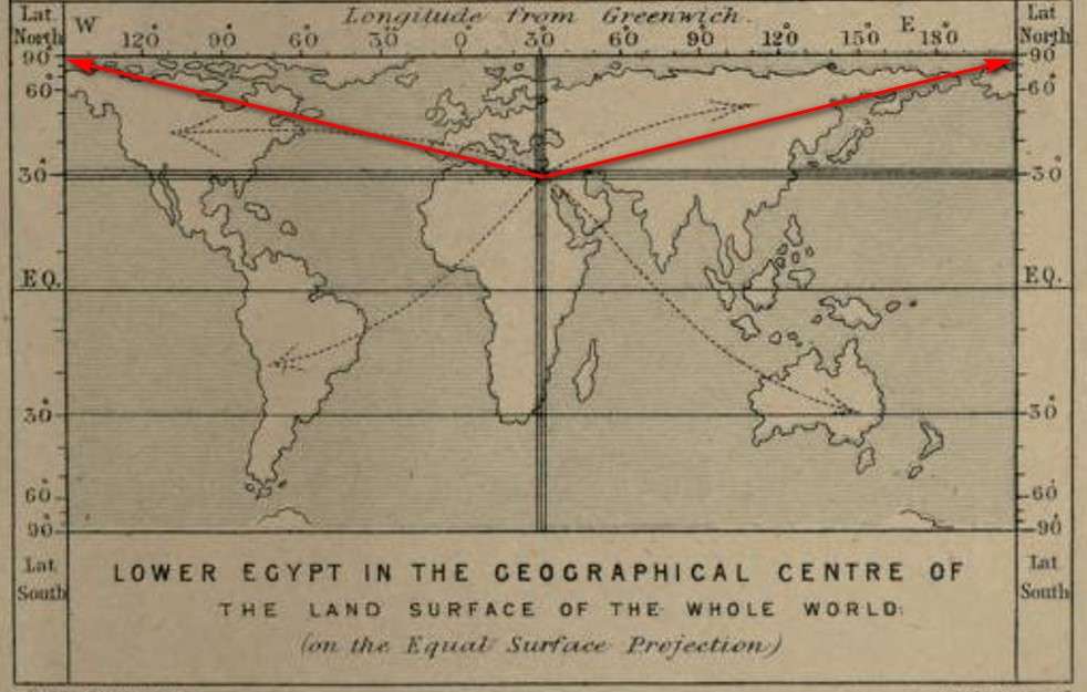
Your source 'Irna' has failed to fully comprehend Smythe's world map and his words:
For, proceeding along the globe due north and due south of the Great Pyramid, it has been found by a good physical geographer as well as engineer, William Petrie [1], that there is more earth and less sea in that meridian than in any other meridian all the world round [...]. Again, taking the distribution of land and sea in parallels of latitude, there is more land surface in the Great Pyramid’s parallel of 30°, than in any other. And finally, on carefully summing up all the dryland habitable by man all the wide world over, the centre of the whole falls within the Great Pyramid’s territory of Lower Egypt. (my emphasis)
Your source considers only the cardinal directions in Smythe's drawing. However, in Smythe's drawing (shown below) we can clearly see that Smythe also includes the ordinal directions (NE, SE, NW, SW) through Giza to give "...all the dryland habitable by man all the wide world over..."

To paraphrase your source, even without recourse to complicated calculations, it is easy to see, that when we include the cardinals AND ordinals (as shown in Smythe's world map above), then the GP located at Giza does indeed fit Professor Smythe's claim.
SC
edit on 21/3/2022 by Scott Creighton because: (no reason given)
originally posted by: Scott Creighton
a reply to: Hooke
SC: Your source 'Irna' has failed to fully comprehend Smythe's world map and his words:
For, proceeding along the globe due north and due south of the Great Pyramid, it has been found by a good physical geographer as well as engineer, William Petrie [1], that there is more earth and less sea in that meridian than in any other meridian all the world round [...]. Again, taking the distribution of land and sea in parallels of latitude, there is more land surface in the Great Pyramid’s parallel of 30°, than in any other. And finally, on carefully summing up all the dryland habitable by man all the wide world over, the centre of the whole falls within the Great Pyramid’s territory of Lower Egypt. (my emphasis)
Your source considers only the cardinal directions in Smythe's drawing. However, in Smythe's drawing (shown below) we can clearly see that Smythe also includes the ordinal directions (NE, SE, NW, SW) through Giza to give "...all the dryland habitable by man all the wide world over..."
To paraphrase your source, even without recourse to complicated calculations, it is easy to see, that when we include the cardinals AND ordinals (as shown in Smythe's world map above), then the GP located at Giza does indeed fit Professor Smythe's claim.
You omitted what she went on to say in the blog article linked above:
Unfortunately for Abbé Moreux, Jacques Grimault, and all the “alternative” authors who have repeated Piazzi Smyth’s claims without checking, there is no proof of any of these pronouncements. Even without recourse to complicated calculations, it is easy to see, as noted here and here, that neither the Giza meridian nor the Giza parallel crosses the "greatest land surface":
Although one of the links cited is no longer working, this one illustrates the point being made.
The article goes on to state:
Note that, using a “rule of thumb” approach, the hypothetical lines on the Piazzi Smyth map above (the meridian marked in blue, and the parallel marked in orange to show the lines "crossing over the more land surface") [2], fall right over the area identified above by Roger Brunet, on a more scientific basis, as "the most central quadrangle," located in Eastern Europe. As we have seen, no matter what method is used, Giza does not match any of these centres of landsurface.
I believe that Irna has said that she has an advanced qualification in geography, so, despite your reservations, I imagine she can understand and read maps: including Smythe's world map.
originally posted by: Hooke
originally posted by: Scott Creighton
a reply to: Hooke
SC: Your source 'Irna' has failed to fully comprehend Smythe's world map and his words:
For, proceeding along the globe due north and due south of the Great Pyramid, it has been found by a good physical geographer as well as engineer, William Petrie [1], that there is more earth and less sea in that meridian than in any other meridian all the world round [...]. Again, taking the distribution of land and sea in parallels of latitude, there is more land surface in the Great Pyramid’s parallel of 30°, than in any other. And finally, on carefully summing up all the dryland habitable by man all the wide world over, the centre of the whole falls within the Great Pyramid’s territory of Lower Egypt. (my emphasis)
Your source considers only the cardinal directions in Smythe's drawing. However, in Smythe's drawing (shown below) we can clearly see that Smythe also includes the ordinal directions (NE, SE, NW, SW) through Giza to give "...all the dryland habitable by man all the wide world over..."
To paraphrase your source, even without recourse to complicated calculations, it is easy to see, that when we include the cardinals AND ordinals (as shown in Smythe's world map above), then the GP located at Giza does indeed fit Professor Smythe's claim.
You omitted what she went on to say in the blog article linked above:
Unfortunately for Abbé Moreux, Jacques Grimault, and all the “alternative” authors who have repeated Piazzi Smyth’s claims without checking, there is no proof of any of these pronouncements. Even without recourse to complicated calculations, it is easy to see, as noted here and here, that neither the Giza meridian nor the Giza parallel crosses the "greatest land surface":
Although one of the links cited is no longer working, this one illustrates the point being made.
The article goes on to state:
Note that, using a “rule of thumb” approach, the hypothetical lines on the Piazzi Smyth map above (the meridian marked in blue, and the parallel marked in orange to show the lines "crossing over the more land surface") [2], fall right over the area identified above by Roger Brunet, on a more scientific basis, as "the most central quadrangle," located in Eastern Europe. As we have seen, no matter what method is used, Giza does not match any of these centres of landsurface.
I believe that Irna has said that she has an advanced qualification in geography, so, despite your reservations, I imagine she can understand and read maps: including Smythe's world map.
Your source makes zero mention of the ordinals which Smythe clearly presents on his map.
Your source only makes their point by completely ignoring the ordinals that are clearly indicated on Smythe's drawing. When you take account of the ordinals shown in Professor Smythe's map then his observation is perfectly correct. It's easy to observe.
SC
edit on 21/3/2022 by Scott Creighton because: (no reason given)
originally posted by: Scott Creighton
Your source makes zero mention of the ordinals which Smythe clearly presents on his map.
Your source only makes their point by completely ignoring the ordinals that are clearly indicated on Smythe's drawing. When you take account of the ordinals shown in Professor Smythe's map then his observation is perfectly correct. It's easy to observe.
The problem here is that the arrows on the map you understand as directions (ordinal directions; in French, "intercardinal" directions) are not "directions" as such.
Instead, they are arrows placed in approximate positions by Piazzi Smyth to give the impression that Giza is in the middle of the earth's landmass (or "land surface of the whole world.")
Look again, for example, at the "north-east" arrow and the "north-west" arrow: they have not been placed at the same angle as each other.
In order that it can be shown as reaching the middle of the earth's landmass from North America, the north-west arrow has been completely curved round.
The same goes for the south-east and south-west arrows. If they were directions, those arrows would both show exactly the same angle of slope with respect to the equator.
But they don't.
a reply to: Scott Creighton
"Hot on the heels of the ScanPyramids research, a new project, Exploring the Great Pyramid (EGP) is set to undertake further muon scans of the GP in order to produce clearer detail of the GP's interior and to produce 3-D images of the interior using powerful muon telescopes mounted around the GP's perimeter. A lot of money is being thrown at finding exactly what is inside the GP!"
What ever these expensive detectors will "catch" there will come a time that a look and see is wished for...and will happen. So, why throw all this money at making use of the most lastest and advanced detectors when drilling a hole and putting a camera through it will be something we all want.
a reply to: Hooke
And they don't for a very obvious reason. (Hint: Giza sits at 30°N and NOT at the equator).
SC
Hooke: Look again, for example, at the "north-east" arrow and the "north-west" arrow: they have not been placed at the same angle as each other.
In order that it can be shown as reaching the middle of the earth's landmass from North America, the north-west arrow has been completely curved round.
The same goes for the south-east and south-west arrows. If they were directions, those arrows would both show exactly the same angle of slope with respect to the equator.
But they don't.
And they don't for a very obvious reason. (Hint: Giza sits at 30°N and NOT at the equator).
SC
originally posted by: zatara
a reply to: Scott Creighton
"Hot on the heels of the ScanPyramids research, a new project, Exploring the Great Pyramid (EGP) is set to undertake further muon scans of the GP in order to produce clearer detail of the GP's interior and to produce 3-D images of the interior using powerful muon telescopes mounted around the GP's perimeter. A lot of money is being thrown at finding exactly what is inside the GP!"
What ever these expensive detectors will "catch" there will come a time that a look and see is wished for...and will happen. So, why throw all this money at making use of the most lastest and advanced detectors when drilling a hole and putting a camera through it will be something we all want.
The Egyptian antiquities authority certainly had no qualms in drilling the small hole through 'Gantenbrink's Door' to push a small camera through. Don't see why this can't be done here - a small hole drilled horizontally from within Campbell's Chamber and an endoscopic camera pushed through?
SC
originally posted by: Scott Creighton
a reply to: Hooke
Hooke: Look again, for example, at the "north-east" arrow and the "north-west" arrow: they have not been placed at the same angle as each other.
In order that it can be shown as reaching the middle of the earth's landmass from North America, the north-west arrow has been completely curved round.
The same goes for the south-east and south-west arrows. If they were directions, those arrows would both show exactly the same angle of slope with respect to the equator.
But they don't.
SC: And they don't for a very obvious reason. (Hint: Giza sits at 30°N and NOT at the equator).
But you've missed the point that what is true for the equator is also true for any parallel, including the 30th, which is shown on Piazzi Smyth's map.
(And my apologies: I think I misspelt Charles Piazzi Smyth's name in my previous post).
originally posted by: Hooke
originally posted by: Scott Creighton
a reply to: Hooke
Hooke: Look again, for example, at the "north-east" arrow and the "north-west" arrow: they have not been placed at the same angle as each other.
In order that it can be shown as reaching the middle of the earth's landmass from North America, the north-west arrow has been completely curved round.
The same goes for the south-east and south-west arrows. If they were directions, those arrows would both show exactly the same angle of slope with respect to the equator.
But they don't.
SC: And they don't for a very obvious reason. (Hint: Giza sits at 30°N and NOT at the equator).
But you've missed the point that what is true for the equator is also true for any parallel, including the 30th, which is shown on Piazzi Smyth's map.
(And my apologies: I think I misspelt Charles Piazzi Smyth's name in my previous post).
No. The asymmetrical curve in Smyth's ordinals is a result of them being made on a flat projection of the world (from the 30th parallel). Had they been made from the equator they would then have been symmetrical.
SC
originally posted by: Scott Creighton
originally posted by: Hooke
originally posted by: Scott Creighton
a reply to: Hooke
Hooke: Look again, for example, at the "north-east" arrow and the "north-west" arrow: they have not been placed at the same angle as each other.
In order that it can be shown as reaching the middle of the earth's landmass from North America, the north-west arrow has been completely curved round.
The same goes for the south-east and south-west arrows. If they were directions, those arrows would both show exactly the same angle of slope with respect to the equator.
But they don't.
SC: And they don't for a very obvious reason. (Hint: Giza sits at 30°N and NOT at the equator).
But you've missed the point that what is true for the equator is also true for any parallel, including the 30th, which is shown on Piazzi Smyth's map.
(And my apologies: I think I misspelt Charles Piazzi Smyth's name in my previous post).
No. The asymmetrical curve in Smyth's ordinals is a result of them being made on a flat projection of the world (from the 30th parallel). Had they been made from the equator they would then have been symmetrical.
No, this makes no sense.
It could explain an asymmetry between north and south arrows on a Mercator type projection: but not the asymmetry between east and west arrows.
We see for example that the north-east arrow is actually pointing roughly in a north-east direction, while the north-west arrow bends to become almost parallel to the equator...
One blatant fact is that there was no other way to build a structure that could reach that height, in the times that they were built in.
For what ever purpose it was built, it needed to elevate something to that height and perhaps even drop something from that height.
The only structure that could do that without falling over , was a pyramid.
What could possibly be that important to go through all of the work to enable having something that tall?
I think that the answer as to why the pyramids were built will manifest itself from the analysis of very simple, fundamental observations.
originally posted by: charlyv
One blatant fact is that there was no other way to build a structure that could reach that height, in the times that they were built in.
For what ever purpose it was built, it needed to elevate something to that height and perhaps even drop something from that height.
The only structure that could do that without falling over , was a pyramid.
What could possibly be that important to go through all of the work to enable having something that tall?
...
A tomb for King Khufu - Great Pyramid as Tomb - on the Web Archive.
a reply to: charlyv
It was the first GPS marker.
The equator to the north pole is almost exactly 10,000 km and they knew that.
The top of the pyramid is much smaller in area to match the numerator.
Puzzle they left was to figure out the 10,000 base 47 denominator.
The people buried there were locals that may not have been the true inspiration for the location and design.
What could possibly be that important to go through all of the work to enable having something that tall?
It was the first GPS marker.
The equator to the north pole is almost exactly 10,000 km and they knew that.
The top of the pyramid is much smaller in area to match the numerator.
Puzzle they left was to figure out the 10,000 base 47 denominator.
The people buried there were locals that may not have been the true inspiration for the location and design.
new topics
-
God's Righteousness is Greater than Our Wrath
Religion, Faith, And Theology: 3 hours ago -
Electrical tricks for saving money
Education and Media: 6 hours ago -
VP's Secret Service agent brawls with other agents at Andrews
Mainstream News: 8 hours ago -
Sunak spinning the sickness figures
Other Current Events: 8 hours ago -
Nearly 70% Of Americans Want Talks To End War In Ukraine
Political Issues: 8 hours ago -
Late Night with the Devil - a really good unusual modern horror film.
Movies: 10 hours ago
top topics
-
VP's Secret Service agent brawls with other agents at Andrews
Mainstream News: 8 hours ago, 9 flags -
Cats Used as Live Bait to Train Ferocious Pitbulls in Illegal NYC Dogfighting
Social Issues and Civil Unrest: 12 hours ago, 8 flags -
Electrical tricks for saving money
Education and Media: 6 hours ago, 4 flags -
HORRIBLE !! Russian Soldier Drinking Own Urine To Survive In Battle
World War Three: 16 hours ago, 3 flags -
Nearly 70% Of Americans Want Talks To End War In Ukraine
Political Issues: 8 hours ago, 3 flags -
Sunak spinning the sickness figures
Other Current Events: 8 hours ago, 3 flags -
Late Night with the Devil - a really good unusual modern horror film.
Movies: 10 hours ago, 2 flags -
The Good News According to Jesus - Episode 1
Religion, Faith, And Theology: 14 hours ago, 1 flags -
God's Righteousness is Greater than Our Wrath
Religion, Faith, And Theology: 3 hours ago, 0 flags
active topics
-
How ageing is" immune deficiency"
Medical Issues & Conspiracies • 34 • : angelchemuel -
Nearly 70% Of Americans Want Talks To End War In Ukraine
Political Issues • 13 • : Freeborn -
Mood Music Part VI
Music • 3101 • : ThatSmellsStrange -
VP's Secret Service agent brawls with other agents at Andrews
Mainstream News • 41 • : ThatSmellsStrange -
HORRIBLE !! Russian Soldier Drinking Own Urine To Survive In Battle
World War Three • 32 • : DaRAGE -
New whistleblower Jason Sands speaks on Twitter Spaces last night.
Aliens and UFOs • 55 • : baablacksheep1 -
Cats Used as Live Bait to Train Ferocious Pitbulls in Illegal NYC Dogfighting
Social Issues and Civil Unrest • 20 • : Asher47 -
Electrical tricks for saving money
Education and Media • 4 • : Lumenari -
DONALD J. TRUMP - 2024 Candidate for President - His Communications to Americans and the World.
2024 Elections • 514 • : WeMustCare -
The Acronym Game .. Pt.3
General Chit Chat • 7744 • : bally001