It looks like you're using an Ad Blocker.
Please white-list or disable AboveTopSecret.com in your ad-blocking tool.
Thank you.
Some features of ATS will be disabled while you continue to use an ad-blocker.

Secret Area 51 Tunnel Openings Discovered On Google Earth, Are They UFO Hangar Entrances?
page: 16
share:
I came across these coordinates and screenshoted the following legit locations around Area 51……they may have been already posted somewhere on
ATS….but for prosperity, I post below.
…….” UFO and alien historian FindingUFO on YouTube has uncovered a few interesting finds by using Google Earth to view Area 51. Those finds, while not evidence of aliens or UFOs, include what he believes are three secret UFO hangar entrances.”……
MARCH 3, 2020 Source: Secret Area 51 Tunnel Openings Discovered On Google Earth, Are They UFO Hangar Entrances?
Google Earth (Area 51 Mountain Entrances) Coordinates:
• 37.1916478725, -116.17319725
• 37°10’23.7″N 116°11’39.4″W
• 37°10’21.17″N 116°11’31.16″W
Area 51 Storage bunkers? Entries to deep facilities? Workshops? Human made Exotic craft hangars? UFO reverse engineering and test facility hangars?
Take your pick….
No telling how many more of these exist (or once existed)…..All roads lead somewhere!!! (active or abandoned).
(I’ve added my own conspiratorial red text thoughts, red arrows, and bottom right red rectangles around the coordinates of each screenshot)


👽🛸🤔🧐🍺
…….” UFO and alien historian FindingUFO on YouTube has uncovered a few interesting finds by using Google Earth to view Area 51. Those finds, while not evidence of aliens or UFOs, include what he believes are three secret UFO hangar entrances.”……
MARCH 3, 2020 Source: Secret Area 51 Tunnel Openings Discovered On Google Earth, Are They UFO Hangar Entrances?
Google Earth (Area 51 Mountain Entrances) Coordinates:
• 37.1916478725, -116.17319725
• 37°10’23.7″N 116°11’39.4″W
• 37°10’21.17″N 116°11’31.16″W
Area 51 Storage bunkers? Entries to deep facilities? Workshops? Human made Exotic craft hangars? UFO reverse engineering and test facility hangars?
Take your pick….
No telling how many more of these exist (or once existed)…..All roads lead somewhere!!! (active or abandoned).
(I’ve added my own conspiratorial red text thoughts, red arrows, and bottom right red rectangles around the coordinates of each screenshot)
👽🛸🤔🧐🍺
edit on 15-11-2021 by Ophiuchus1 because: (no reason given)
a reply to: Ophiuchus1
Thanks for posting. There was a thread on this from a few years back, but I'm not finding it.
37.1916481, -116.1731971
Looks like they got a bit more done, but not to much though. 👍🏼😊
Thanks for posting. There was a thread on this from a few years back, but I'm not finding it.
37.1916481, -116.1731971
Looks like they got a bit more done, but not to much though. 👍🏼😊
originally posted by: Ophiuchus1
a reply to: Bigburgh
YW…..
No telling how many more of these exist. All roads lead somewhere.
👽🛸🤔🍺
Yes, I'm looking over the map now. I've found a few other (man-made structures into the hillsides ) but without the dirt roads leading up to or nearby, it's tricky to spot sometimes. Lol.. takes a good eye and a little knowledge of the terrain.
Again I much apreciate your efforts and posting of this thread. I almost forgot about a few of these. I have many marked on Google I'll have to re look at.
I love looking at maps. Should have taken the job down near Rockville Maryland as a cartographer .
a reply to: Ophiuchus1
To ponder: If you were them ...wouldn't we put these things out there...for us to "discover"?
All the while ..there's real entrances. Wherever.....
To ponder: If you were them ...wouldn't we put these things out there...for us to "discover"?
All the while ..there's real entrances. Wherever.....
a reply to: Bigburgh
So far, I’ve found 7 roads leading down to Papoose dry bed lake. No telling, so far, if there are road portions along the shoreline around the lake.
The GE version I have does not show Altitudes, unless it’s an option in the settings. But again, the coordinates are always on the bottom right of each screenshot.
Ive maintained the same compass orientation throughout all screenshots.
Starting with “The Pepper” I go around the lake counter clockwise.
Top to bottom - Left to right…..
Notice the one large width road, second to last screenshot….Not having an altitude to extrapolate how wide it is….. I’m going to assume it’s pretty wide…….So then you have to wonder what size of anything being hauled to and from the lake, had to be to require a road so wide?

The last screenshot is an expansion screenshot of the road seen to the right of The Pepper in the first screenshot…

👽🧐🤔🍷
So far, I’ve found 7 roads leading down to Papoose dry bed lake. No telling, so far, if there are road portions along the shoreline around the lake.
The GE version I have does not show Altitudes, unless it’s an option in the settings. But again, the coordinates are always on the bottom right of each screenshot.
Ive maintained the same compass orientation throughout all screenshots.
Starting with “The Pepper” I go around the lake counter clockwise.
Top to bottom - Left to right…..
Notice the one large width road, second to last screenshot….Not having an altitude to extrapolate how wide it is….. I’m going to assume it’s pretty wide…….So then you have to wonder what size of anything being hauled to and from the lake, had to be to require a road so wide?
The last screenshot is an expansion screenshot of the road seen to the right of The Pepper in the first screenshot…
👽🧐🤔🍷
edit on 15-11-2021 by Ophiuchus1 because: (no reason given)
originally posted by: mysterioustranger
a reply to: Ophiuchus1
To ponder: If you were them ...wouldn't we put these things out there...for us to "discover"?
All the while ..there's real entrances. Wherever.....
From the article link in my OP…..
……” while one person astutely pointed out, “If you can see it they want you to see it because it is a diversion. This is just one big honey pot.”….
Of course….it can be Deception…..

👽🍻
edit on 15-11-2021 by Ophiuchus1 because: (no reason given)
Ahhh area of 51aka known as the great sleeping Dragon. Any signs of awakening yet?
Can't be far off.
Can't be far off.
Why does everything always look so 'junky' there?
Like a junkyard or the backyard of a hoarder.
Stuff scattered all around, doesn't look like what a super top secret facility dealing with advanced aerial craft would be expected to look like.
Like a junkyard or the backyard of a hoarder.
Stuff scattered all around, doesn't look like what a super top secret facility dealing with advanced aerial craft would be expected to look like.
a reply to: Ophiuchus1
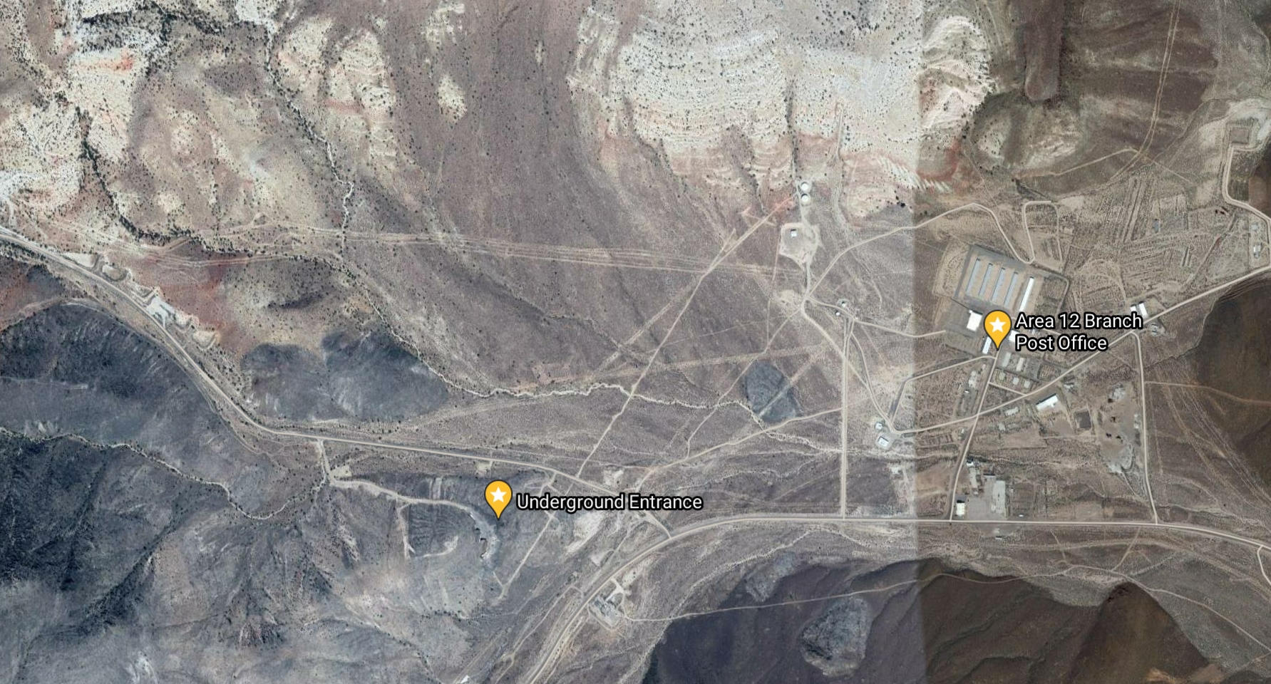
The coordinates you cited are for tunnels within Area 12 of the Nevada National Security Site (NNSS, formerly the Nevada Test Site). I have visited Area 12 on several occasions, and seen these and other entrances. The tunnels were used for conducting 61 subterranean nuclear tests between 1957 and 1992, one of which involved two simultaneous detonations. The Area 12 tunnel complexes were excavated beneath Rainier Mesa and Aqueduct Mesa.
The coordinates you cited are for tunnels within Area 12 of the Nevada National Security Site (NNSS, formerly the Nevada Test Site). I have visited Area 12 on several occasions, and seen these and other entrances. The tunnels were used for conducting 61 subterranean nuclear tests between 1957 and 1992, one of which involved two simultaneous detonations. The Area 12 tunnel complexes were excavated beneath Rainier Mesa and Aqueduct Mesa.
originally posted by: Shadowhawk
a reply to: Ophiuchus1
The coordinates you cited are for tunnels within Area 12 of the Nevada National Security Site (NNSS, formerly the Nevada Test Site). I have visited Area 12 on several occasions, and seen these and other entrances. The tunnels were used for conducting 61 subterranean nuclear tests between 1957 and 1992, one of which involved two simultaneous detonations. The Area 12 tunnel complexes were excavated beneath Rainier Mesa and Aqueduct Mesa.
Yes Yes....I see my Folly Now....now that I'm using a better desktop version of Google Earth to plot multiple Coordinates at the same time....much better than the plugin for my Crapple IPad Mini.
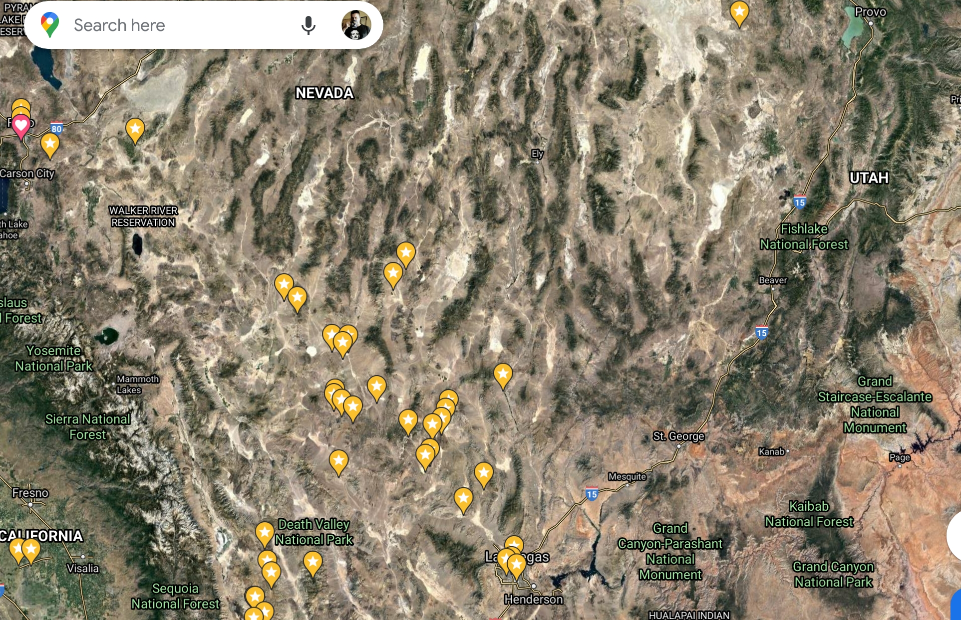
The Area "51" (12) coordinates from my OP article linked are quite some distance from Area 51 and Papoose Lake.
Lesson Learned?? Use better and updated map tools....Sacrebleu!!!

If anything…..it does show facilities and infrastructure are buildable within the topography of those types of Areas. Still can’t discount that facilities such as Area 12 are not also within Area 51….. just hasn’t been found yet 😉
👽👍🏼🍻🤭
edit on 15-11-2021 by Ophiuchus1 because: (no reason given)
a reply to: Ophiuchus1
Got that right. 1st thing would be to put fake ones out there.
Im glad all you guys dig into the photos as well as you do!
If you didnt...that knowledge wouldnt reach people.
Great finds.
Got that right. 1st thing would be to put fake ones out there.
Im glad all you guys dig into the photos as well as you do!
If you didnt...that knowledge wouldnt reach people.
Great finds.
a reply to: Ophiuchus1
Those look clearly something interesting. They do seem like entrances or Hangar.
Those look clearly something interesting. They do seem like entrances or Hangar.
edit on 15-11-2021 by HawkEyi because: (no reason
given)
new topics
-
whistleblower Captain Bill Uhouse on the Kingman UFO recovery
Aliens and UFOs: 4 hours ago -
1980s Arcade
General Chit Chat: 6 hours ago -
Deadpool and Wolverine
Movies: 7 hours ago -
Teenager makes chess history becoming the youngest challenger for the world championship crown
Other Current Events: 8 hours ago -
CIA botched its handling of sexual assault allegations, House intel report says
Breaking Alternative News: 9 hours ago -
Lawsuit Seeks to ‘Ban the Jab’ in Florida
Diseases and Pandemics: 11 hours ago
top topics
-
Lawsuit Seeks to ‘Ban the Jab’ in Florida
Diseases and Pandemics: 11 hours ago, 20 flags -
Starburst galaxy M82 - Webb Vs Hubble
Space Exploration: 13 hours ago, 13 flags -
The Superstition of Full Moons Filling Hospitals Turns Out To Be True!
Medical Issues & Conspiracies: 15 hours ago, 8 flags -
CIA botched its handling of sexual assault allegations, House intel report says
Breaking Alternative News: 9 hours ago, 8 flags -
15 Unhealthiest Sodas On The Market
Health & Wellness: 14 hours ago, 6 flags -
whistleblower Captain Bill Uhouse on the Kingman UFO recovery
Aliens and UFOs: 4 hours ago, 6 flags -
Teenager makes chess history becoming the youngest challenger for the world championship crown
Other Current Events: 8 hours ago, 3 flags -
Deadpool and Wolverine
Movies: 7 hours ago, 3 flags -
1980s Arcade
General Chit Chat: 6 hours ago, 3 flags
active topics
-
1980s Arcade
General Chit Chat • 8 • : F2d5thCavv2 -
What is a dream
The Gray Area • 27 • : wrayth -
Europe declares war on Russia?
World War Three • 61 • : F2d5thCavv2 -
The Acronym Game .. Pt.3
General Chit Chat • 7741 • : F2d5thCavv2 -
Russia Ukraine Update Thread - part 3
World War Three • 5713 • : F2d5thCavv2 -
IDF Intel Chief Resigns Over Hamas attack
Middle East Issues • 32 • : Terpene -
15 Unhealthiest Sodas On The Market
Health & Wellness • 32 • : VariedcodeSole -
Fast Moving Disc Shaped UFO Captured on Camera During Flight from Florida to New York City
Aliens and UFOs • 18 • : inflaymes69 -
Definitive 9.11 Pentagon EVIDENCE.
9/11 Conspiracies • 419 • : SchrodingersRat -
They Killed Dr. Who for Good
Rant • 61 • : Cymru
6