It looks like you're using an Ad Blocker.
Please white-list or disable AboveTopSecret.com in your ad-blocking tool.
Thank you.
Some features of ATS will be disabled while you continue to use an ad-blocker.

Hurricane Dorian taking aim at Florida
page: 7share:
Just saw this posted on Facebook...converted to YouTube in order to post.
This was taken while the eye was over them, they still have the whole back half of this monster storm to endure. Prayers they make it through.
This was taken while the eye was over them, they still have the whole back half of this monster storm to endure. Prayers they make it through.
originally posted by: Nyiah
Personally, intuition being what it is for growing up in FL myself, I say this one's going to hug the coast and not actually make landfall there, with the HF wind wall just offshore. Bahamas are going to get the bulk of the whipping, obviously.
I also could be wrong. I hunkered down for Charley thinking "Huh, this'll be interesting" in Tampa, and was totally not expecting the right hook into Punta Gorda he did back then (nobody expected that except ONE local meteorologist who didn't back off the prediction)
Edit: Clicky here for the current blog on WU. It's a good central location for all kinds of meteorology goodies for the hurricane, as well as any images from locations in the path. New blogs are linked in at the top of the comments section, it's not hard to spot.
LMAO, I was just north of you at that time as well. Looking back we were probably really dumb for waiting to see if Charlie would run up Tampa Bay. That would have been a devastating hit with massive storm surge.
Still in Florida hoping it turns, if not I have my work cut out for me boarding up the house and getting the kids out of here.
Steve Gervy was the man with his Viper radar that day. Call of the century. He made them all look like fools that day and likely saved many lives in the process. My Grandmother in Orlando was able to get to a shelter for starters.
edit on 1-9-2019 by RudeMarine because: added
content
Dorian has stalled over Grand Bahama all morning. This an unfathomable catastrophe in the making. While the storm has weakened slightly, 165mph
sustained winds with 200mph gusts, it is still a category 5 hurricane.
Dorian is supposed to begin a weakening trend today followed by a gradual turn to the north, then accelerating to the northeast by Wednesday.
It appears the chances of a direct hit are diminishing for Florida, however Dorian remains a major threat to the rest of the Southeast US coastline.
Even without a direct Dorian can still bring hurricane force winds and storm surge flooding to Florida and the rest of the SE coastline.
My parents in Cocoa Beach are expecting a call from me this morning, and my advice to stay or go. They are under a mandatory evacuation, however we are Floridians and only run when absolutely necessary.
a reply to: jrod
I’m an hour north of Cocoa Beach in Volusia county. I saw we will get winds of 75-110! This will be my 8th hurricane. Honestly they’re annoying lol I feel like I’ve lost a week of my life waiting for this thing to get here. We are going to a friends who has a generator and doesn’t live under dozens of 150 year old oak trees! I live in an oak canopy. The storms of 2016/2017 cleared most of them out but the winds weren’t as strong as they say they will be for this one. Soooo im not staying! I’ll move my car to the plaza by my house which is where most people on my street park their cars. It’s open and no trees. This is just going to suck because I know I’ll have no power and no idea for how long at my place. I lost my job two weeks ago so I’m even more stressed as it will take longer to get one with this sucker hitting here. Fun times...
I’m an hour north of Cocoa Beach in Volusia county. I saw we will get winds of 75-110! This will be my 8th hurricane. Honestly they’re annoying lol I feel like I’ve lost a week of my life waiting for this thing to get here. We are going to a friends who has a generator and doesn’t live under dozens of 150 year old oak trees! I live in an oak canopy. The storms of 2016/2017 cleared most of them out but the winds weren’t as strong as they say they will be for this one. Soooo im not staying! I’ll move my car to the plaza by my house which is where most people on my street park their cars. It’s open and no trees. This is just going to suck because I know I’ll have no power and no idea for how long at my place. I lost my job two weeks ago so I’m even more stressed as it will take longer to get one with this sucker hitting here. Fun times...
Key messages and updated forecast track, aka the cone of uncertainty.
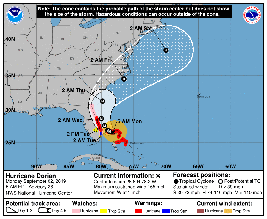
Key Messages:
1. A prolonged period of catastrophic winds and storm surge will
continue to affect Grand Bahama Island through today and tonight.
Everyone there should remain in shelter and not venture into the
eye.
2. Life-threatening storm surges and dangerous hurricane-force winds
are expected along portions of the Florida east coast through
mid-week, and storm surge and hurricane warnings are in effect. Only
a slight deviation to the left of the official forecast would bring
the core of Dorian near or over the Florida east coast. Residents
should listen to advice given by local emergency officials.
3. There is an increasing likelihood of strong winds and dangerous
storm surge along the coasts of Georgia, South Carolina, and North
Carolina later this week. Residents in these areas should continue
to monitor the progress of Dorian and listen to advice given by
local emergency officials.
4. Heavy rains, capable of producing life-threatening flash floods,
are expected over northern portions of the Bahamas and coastal
sections of the Southeast and lower Mid-Atlantic regions of the
United States into Friday.
FORECAST POSITIONS AND MAX WINDS
INIT 02/0900Z 26.6N 78.2W 145 KT 165 MPH
12H 02/1800Z 26.7N 78.7W 140 KT 160 MPH
24H 03/0600Z 26.9N 79.0W 130 KT 150 MPH
36H 03/1800Z 27.6N 79.5W 120 KT 140 MPH
48H 04/0600Z 28.7N 80.0W 110 KT 125 MPH
72H 05/0600Z 31.3N 79.8W 100 KT 115 MPH
96H 06/0600Z 34.5N 76.5W 85 KT 100 MPH
120H 07/0600Z 38.5N 70.0W 75 KT 85 MPH
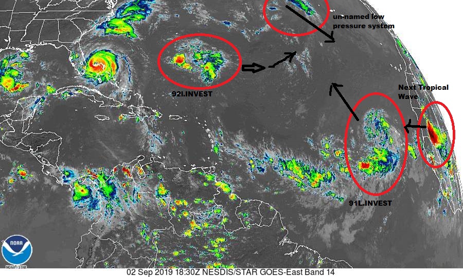
I'm providing a link to the Storm2k forums. The forum is loaded with professional meteorologists, the latest computer models, hurricane recon, and
storm position.
www.storm2k.org...
Generally linking other forums is not allowed on here, but given this is a life threatening event and potentially life and property saving information Is provided there, exceptions can be made.
www.storm2k.org...
Generally linking other forums is not allowed on here, but given this is a life threatening event and potentially life and property saving information Is provided there, exceptions can be made.
originally posted by: mblahnikluver
a reply to: jrod
I’m an hour north of Cocoa Beach in Volusia county. I saw we will get winds of 75-110! This will be my 8th hurricane. Honestly they’re annoying lol I feel like I’ve lost a week of my life waiting for this thing to get here. We are going to a friends who has a generator and doesn’t live under dozens of 150 year old oak trees! I live in an oak canopy. The storms of 2016/2017 cleared most of them out but the winds weren’t as strong as they say they will be for this one. Soooo im not staying! I’ll move my car to the plaza by my house which is where most people on my street park their cars. It’s open and no trees. This is just going to suck because I know I’ll have no power and no idea for how long at my place. I lost my job two weeks ago so I’m even more stressed as it will take longer to get one with this sucker hitting here. Fun times...
Hey fellow Floridian. We are boarded and stocked here in NSB, ready to ride this thing out tomorrow. Power is the worst part. Last one (Matthew I believe) we were without power for 12 days, while the rest of my neighborhood had power on day 1. Hoping for the best with this one. Good luck to you!
edit on 2-9-2019 by KnoxMSP because: (no reason given)
a reply to: mblahnikluver
I have some friends there. I know one just left Daytona Beach Shores to go inland.
I have some friends there. I know one just left Daytona Beach Shores to go inland.
a reply to: jrod
I cannot fathom what it must be like for those poor souls in the Bahamas right now.
Around here, we call an F-5 tornado the "Finger of God." It simply erases whatever it touches: homes, neighborhoods, sometimes entire towns. There is a small town not very far from me that used to be the county seat, until an F-5 came through one night. The town still exists, but only as a "wide spot in the road." The devastation was so bad, the county seat was relocated.
A hurricane spawns these monsters. It is the mother of tornadoes. That's a whole 'nother level of destruction.
As I understand it, the Bahamas is now under several feet of water... the whole damn island is under several feet of rushing water driven by those crazy-powerful winds! Once this monster leaves, I imagine we will see pictures and video of devastation on a scale few of us can really imagine. The death toll has to be massive... I don't see how anyone could survive this. Freeport may not even exist any more.
TheRedneck
a reply to: TheRedneck
I've been to Freeport. I can't imagine much being left. Some areas have been experiencing cat 5 conditions for close to 8 hours. That is like a F3 tornado....for 8 hours!
Absolute worst case scenario I have ever seen in a hurricane.
Florida is not out of the woods yet either.
I've been to Freeport. I can't imagine much being left. Some areas have been experiencing cat 5 conditions for close to 8 hours. That is like a F3 tornado....for 8 hours!
Absolute worst case scenario I have ever seen in a hurricane.
Florida is not out of the woods yet either.
a reply to: jrod
Never been there myself... my timing sucks. My first glimpse of New York City was early 2002, just a few months after the Trade Towers fell. If my luck holds, I'll soon get to see where Freeport once stood.
If I could think of a worse situation a hurricane could cause, I might argue with you. But I can't, so I won't.
Stay safe Florida... and the rest of the coast. This is far, far, far from over.
TheRedneck
Freeport airport reporting wind from west at 92 mph at 9:39 am.
WU
Grand Bahama International Airport, wind NW at 88, gust 115.
WU
Grand Bahama International Airport, wind NW at 88, gust 115.
edit on 9/2/2019 by roadgravel because: (no reason given)
Found a Twitter post the the Freeport Airport completely submerged:
twitter.com...
The storm is now a category 4, with approx 150mph winds. Still barely moving and hammering Grand Bahama island.
twitter.com...
The storm is now a category 4, with approx 150mph winds. Still barely moving and hammering Grand Bahama island.
a reply to: jrod
Looks like it has stalled over Bahamas. (corrected).
www.nrlmry.navy.mil.../at lantic/tropics/ir_color&ANIM_TYPE=Instant&DISPLAY=Single
Bad for the Bahamas. Very bad.
Looks like it has stalled over Bahamas. (corrected).
www.nrlmry.navy.mil.../at lantic/tropics/ir_color&ANIM_TYPE=Instant&DISPLAY=Single
Bad for the Bahamas. Very bad.
edit on V472019Mondaypm30America/ChicagoMon, 02 Sep 2019 14:47:26 -05001 by Violater1 because: phage told me so
NOAA 10 minute delay RADAR can be found here:
radar.weather.gov...
GEOS 20 minute delay can be found here:
www.star.nesdis.noaa.gov...
radar.weather.gov...
GEOS 20 minute delay can be found here:
www.star.nesdis.noaa.gov...
originally posted by: Violater1
a reply to: jrod
Looks like it has stalled over Bahamas. (corrected).
Yes, it was forecast to do that yesterday, for upwards of 24 hours before turning north.
www.nrlmry.navy.mil... ATH=/atlantic/tropics/ir_color&ANIM_TYPE=Instant&DISPLAY=Single
Bad for Cuba. Very bad.
No it isn't. Knock off the misinformation, Cuba is too far south for any direct impact. No atmospheric steering will send it close to Cuba. Florida, yes, Eastern Seaboard, yes. Cuba, NO.
new topics
-
Cats Used as Live Bait to Train Ferocious Pitbulls in Illegal NYC Dogfighting
Social Issues and Civil Unrest: 47 minutes ago -
The Good News According to Jesus - Episode 1
Religion, Faith, And Theology: 2 hours ago -
HORRIBLE !! Russian Soldier Drinking Own Urine To Survive In Battle
World War Three: 4 hours ago -
Bobiverse
Fantasy & Science Fiction: 7 hours ago -
Florida man's trip overseas ends in shock over $143,000 T-Mobile phone bill
Social Issues and Civil Unrest: 7 hours ago -
Former Labour minister Frank Field dies aged 81
People: 9 hours ago -
SETI chief says US has no evidence for alien technology. 'And we never have'
Aliens and UFOs: 11 hours ago
top topics
-
President BIDEN Vows to Make Americans Pay More Federal Taxes in 2025 - Political Suicide.
2024 Elections: 16 hours ago, 19 flags -
Florida man's trip overseas ends in shock over $143,000 T-Mobile phone bill
Social Issues and Civil Unrest: 7 hours ago, 8 flags -
SETI chief says US has no evidence for alien technology. 'And we never have'
Aliens and UFOs: 11 hours ago, 7 flags -
Former Labour minister Frank Field dies aged 81
People: 9 hours ago, 4 flags -
Bobiverse
Fantasy & Science Fiction: 7 hours ago, 3 flags -
Ode to Artemis
General Chit Chat: 17 hours ago, 3 flags -
This is our Story
General Entertainment: 14 hours ago, 3 flags -
Cats Used as Live Bait to Train Ferocious Pitbulls in Illegal NYC Dogfighting
Social Issues and Civil Unrest: 47 minutes ago, 3 flags -
HORRIBLE !! Russian Soldier Drinking Own Urine To Survive In Battle
World War Three: 4 hours ago, 2 flags -
The Good News According to Jesus - Episode 1
Religion, Faith, And Theology: 2 hours ago, 0 flags
active topics
-
-@TH3WH17ERABB17- -Q- ---TIME TO SHOW THE WORLD--- -Part- --44--
Dissecting Disinformation • 648 • : RookQueen2 -
HORRIBLE !! Russian Soldier Drinking Own Urine To Survive In Battle
World War Three • 19 • : KnowItAllKnowNothin -
Florida man's trip overseas ends in shock over $143,000 T-Mobile phone bill
Social Issues and Civil Unrest • 14 • : Raptured -
DerBeobachter - Electric Boogaloo 2
Introductions • 14 • : ElitePlebeian2 -
LaBTop is back at last.
Introductions • 16 • : ElitePlebeian2 -
VirginOfGrand says hello
Introductions • 4 • : ElitePlebeian2 -
TLDR post about ATS and why I love it and hope we all stay together somewhere
General Chit Chat • 9 • : ElitePlebeian2 -
SETI chief says US has no evidence for alien technology. 'And we never have'
Aliens and UFOs • 32 • : bhtaylor53 -
Breaking Baltimore, ship brings down bridge, mass casualties
Other Current Events • 480 • : IndieA -
President BIDEN Vows to Make Americans Pay More Federal Taxes in 2025 - Political Suicide.
2024 Elections • 87 • : FlyersFan