It looks like you're using an Ad Blocker.
Please white-list or disable AboveTopSecret.com in your ad-blocking tool.
Thank you.
Some features of ATS will be disabled while you continue to use an ad-blocker.

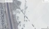
Possible underground entrance on Groom Lake & other strangeness
page: 1share:
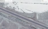
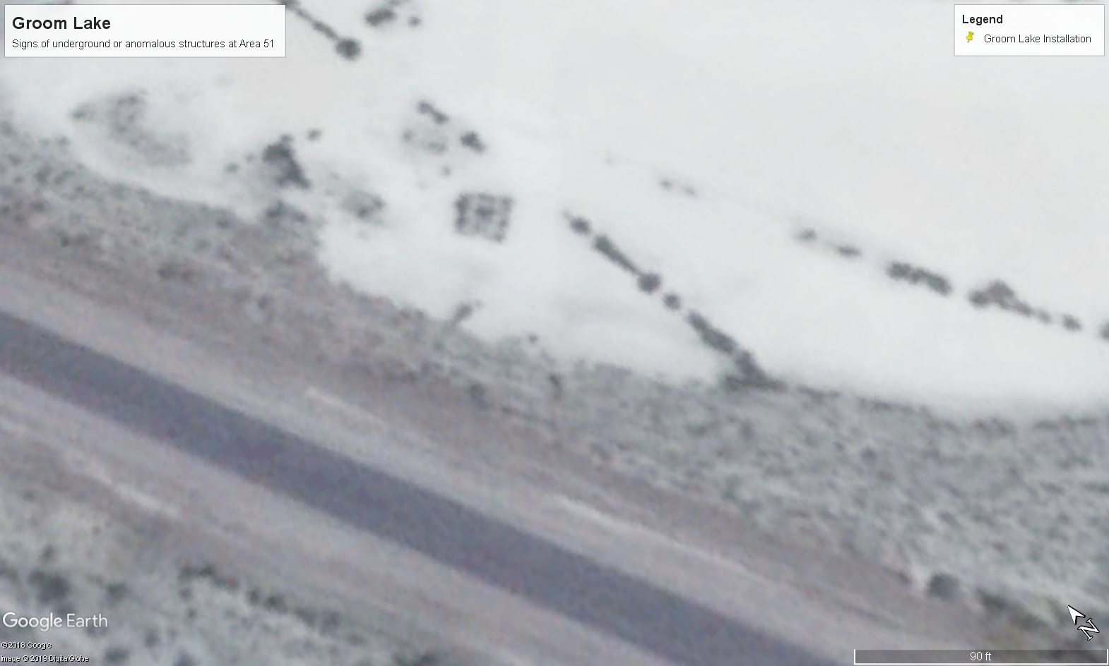
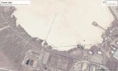
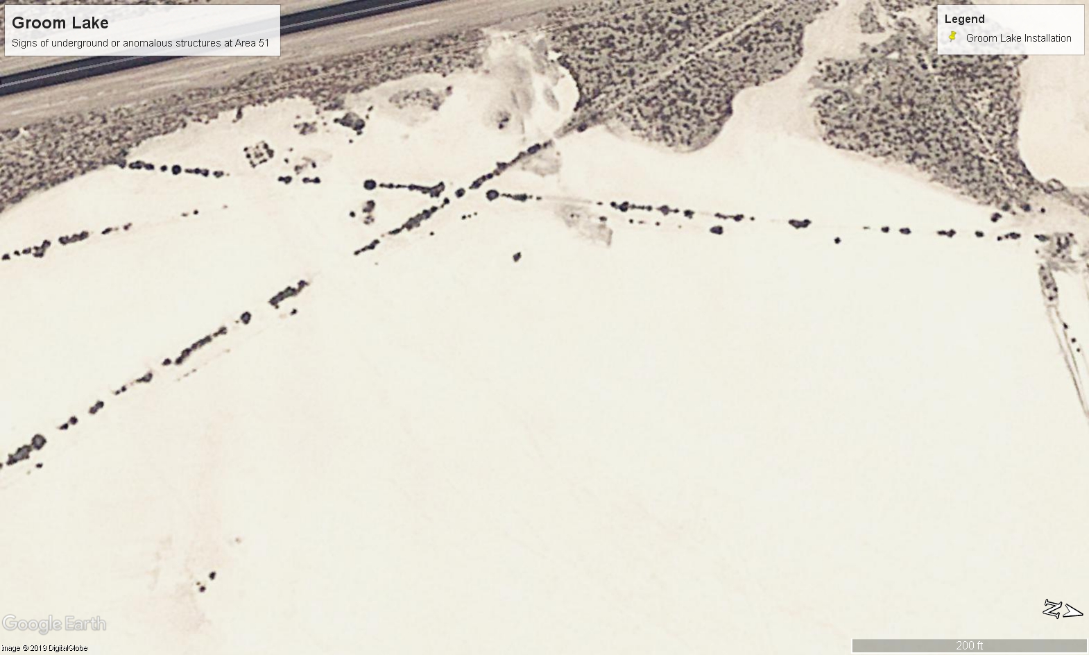
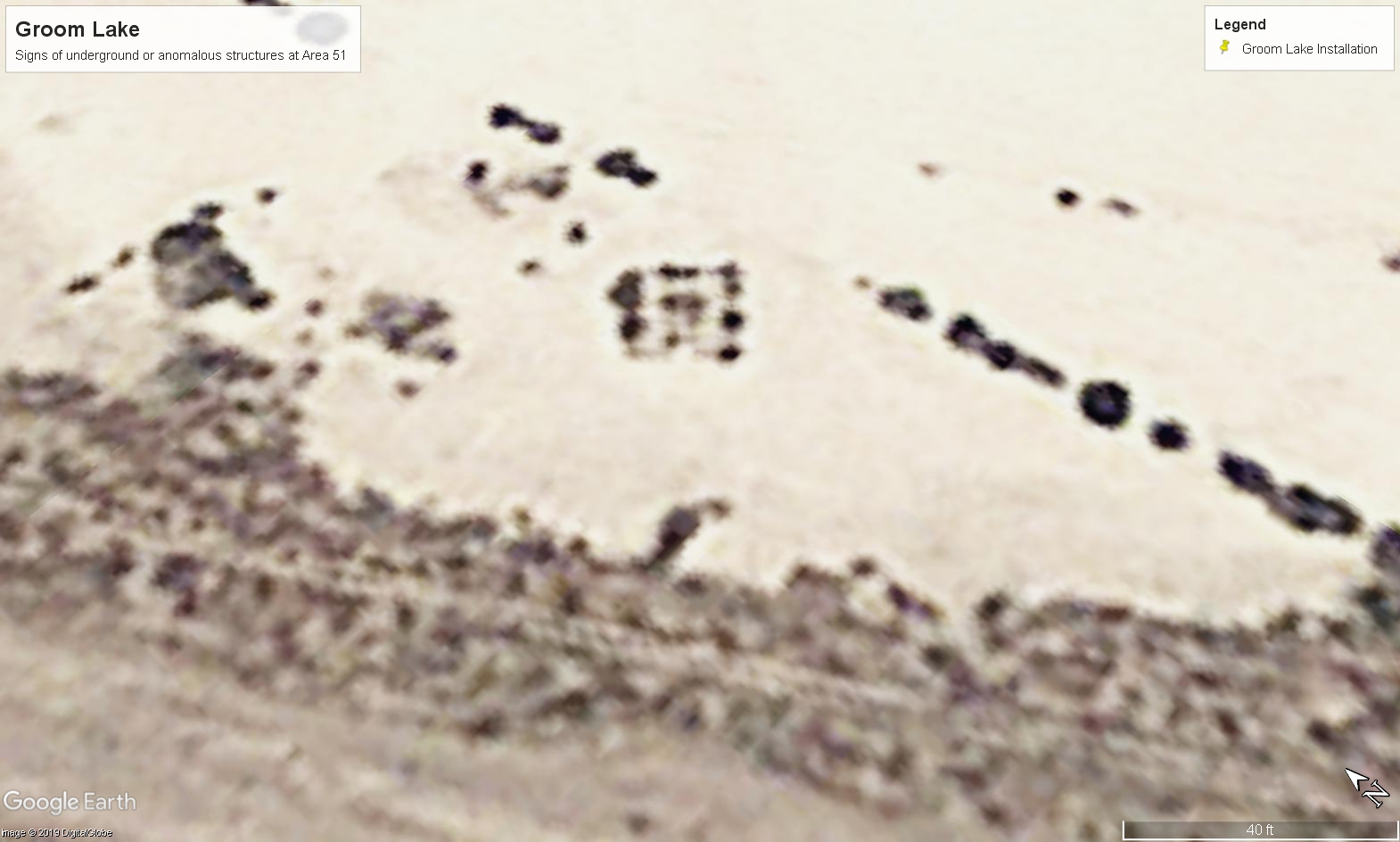
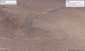
Here is the anomalous, U-shaped possible "entrance" directly on Groom Lake

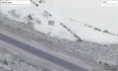

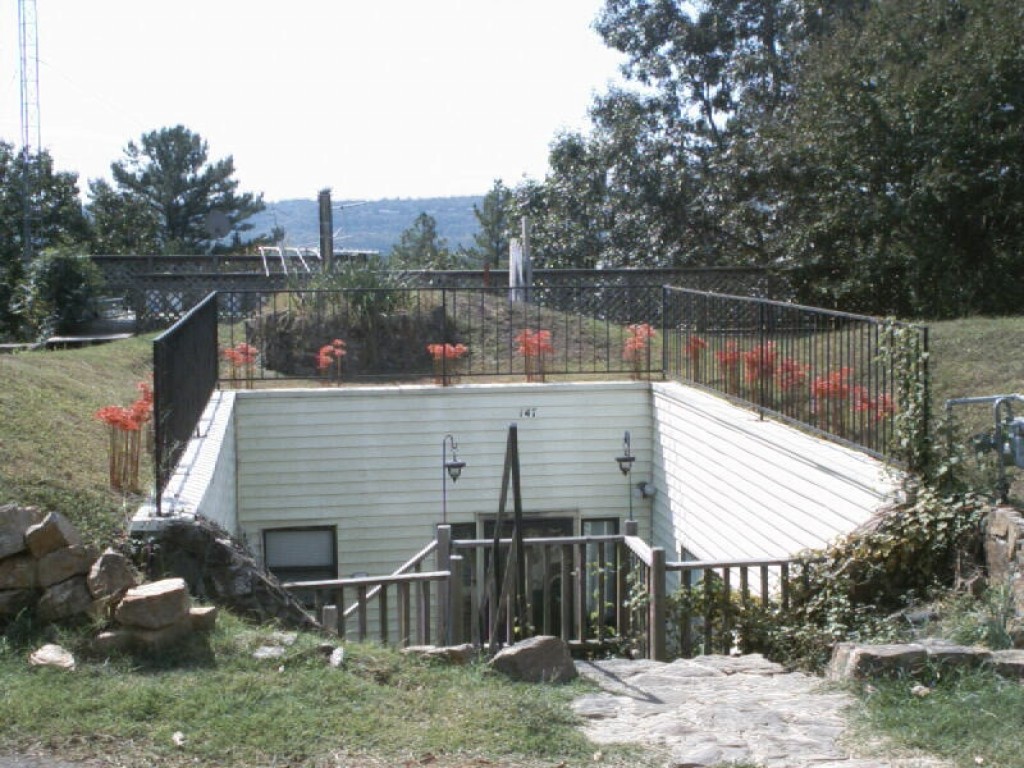
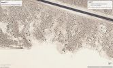
Here is one example of an entrance to a sub-surface structure, in this case a home:
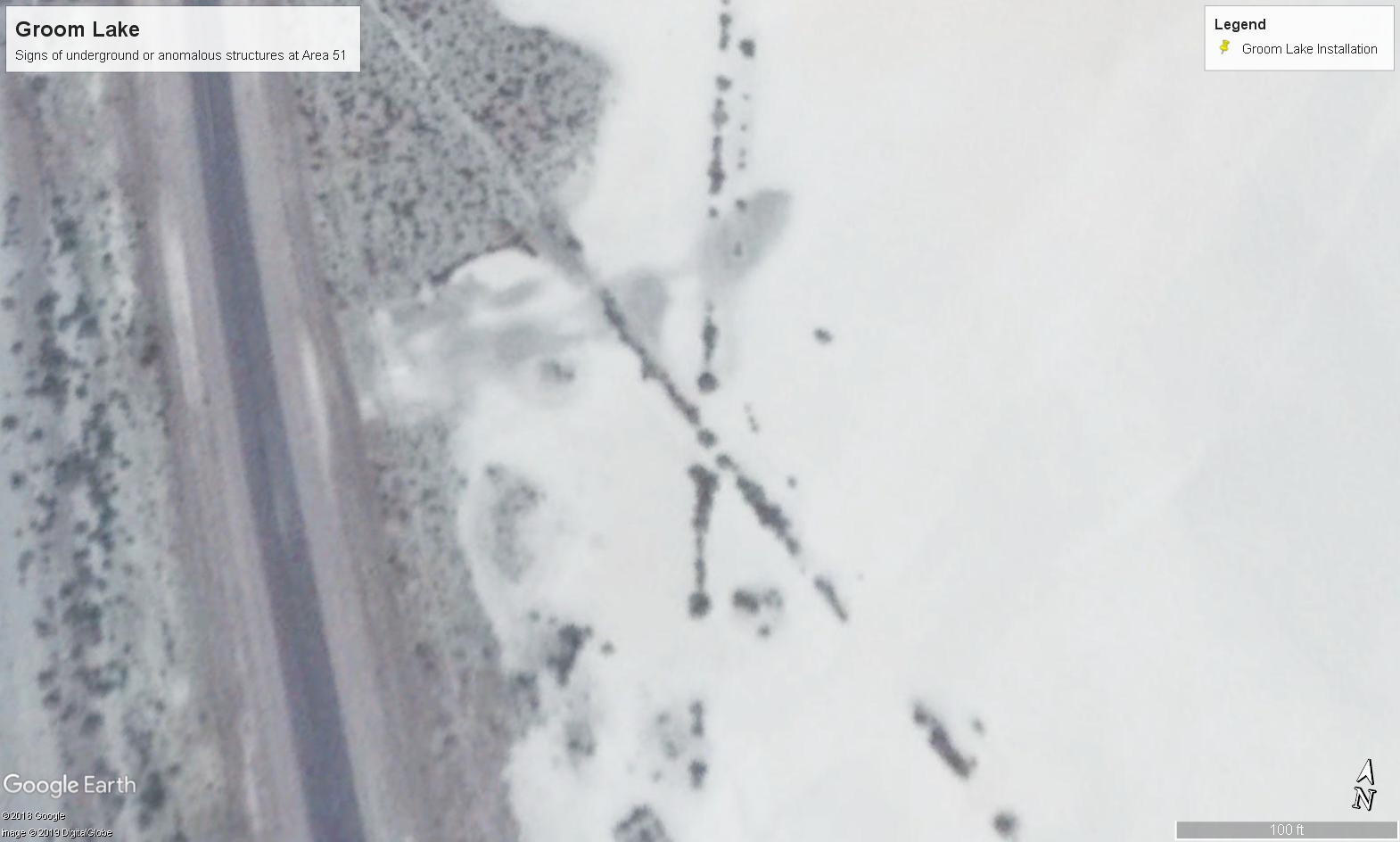
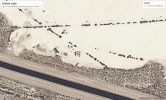
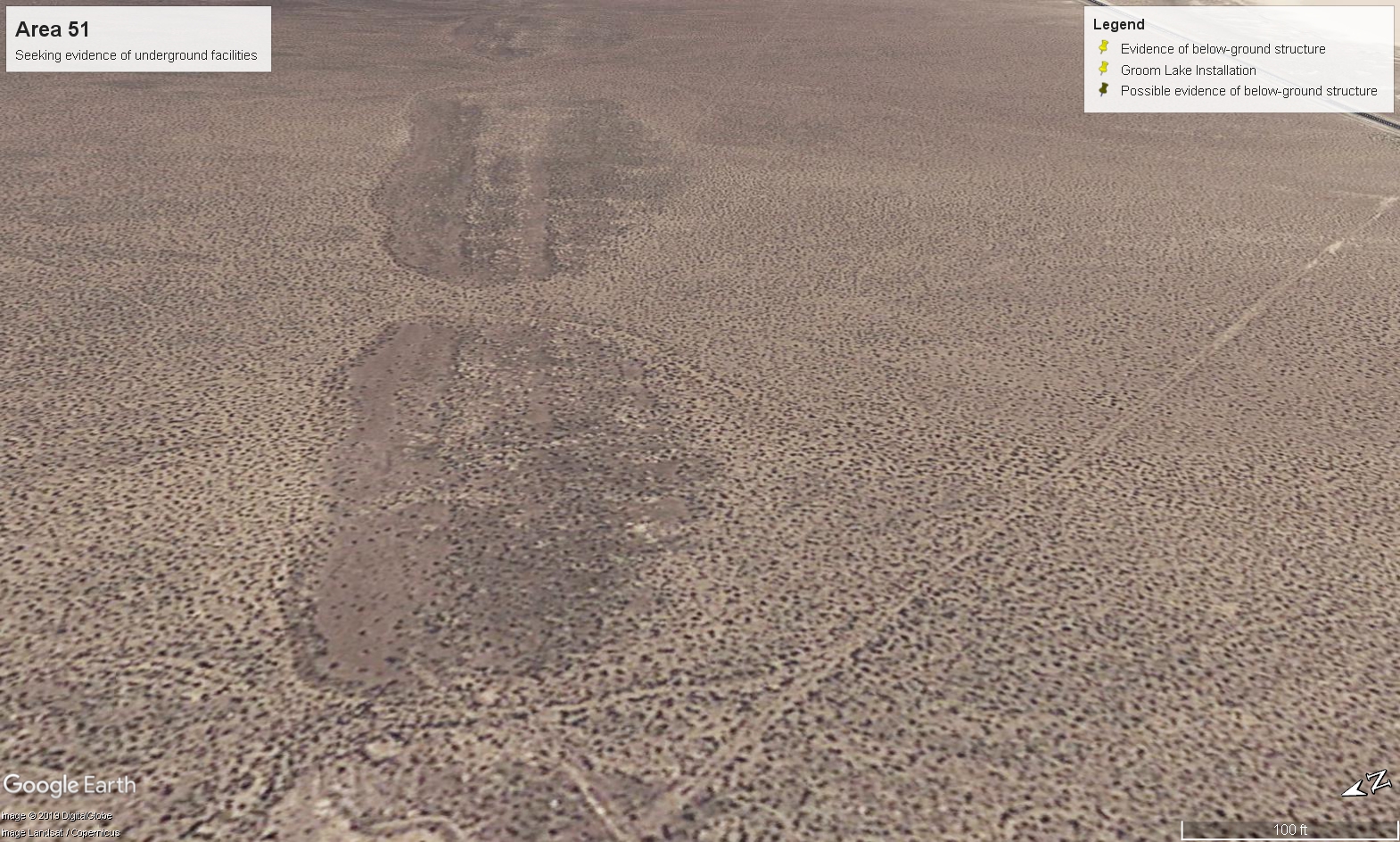
In addition, this area and the "shores" of Groom Dry Lake also have structures/markings that could indicate tracks or some other sort of rail transportation. The one, with images spanning multiple years, shows a clearly metallic structure that has a glint of sun reflecting showing its metallic nature
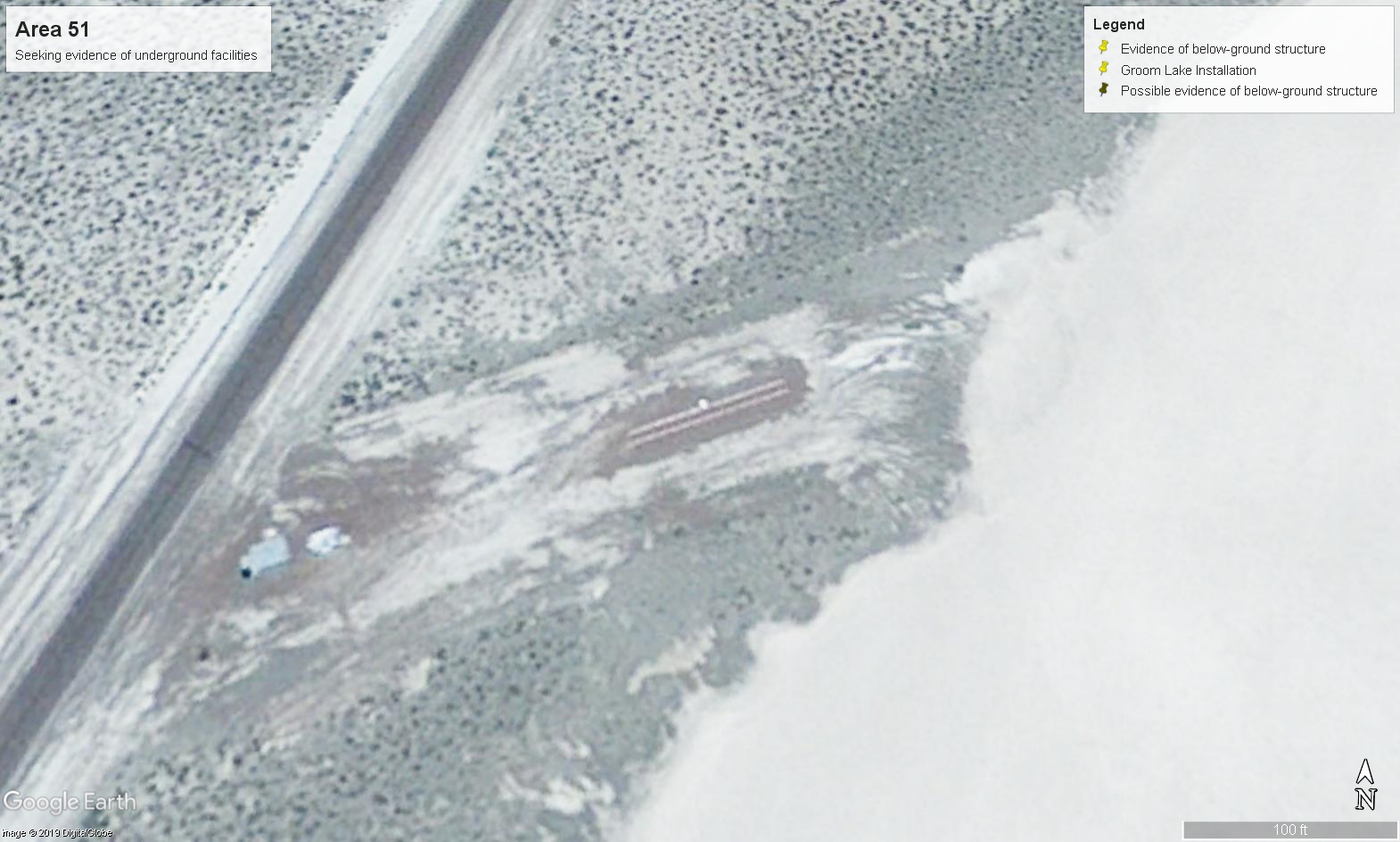


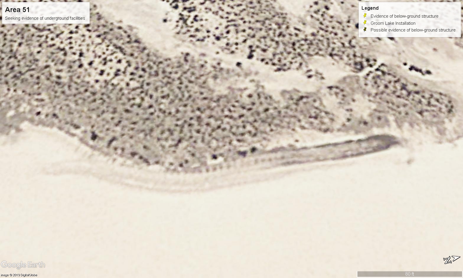
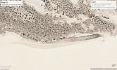

Notice the linear feel of this area/path. Could this be subsidence due to underground tunnels? Evidence of excavation and backfilling? One of MUFON's case files (Can't remember which specifically) includes a witness statement describing an underground transportation network that is said to be capable of fitting two B-52 bombers side by side


Here is one example of an entrance to a sub-surface structure, in this case a home:
In addition, this area and the "shores" of Groom Dry Lake also have structures/markings that could indicate tracks or some other sort of rail transportation. The one, with images spanning multiple years, shows a clearly metallic structure that has a glint of sun reflecting showing its metallic nature
Notice the linear feel of this area/path. Could this be subsidence due to underground tunnels? Evidence of excavation and backfilling? One of MUFON's case files (Can't remember which specifically) includes a witness statement describing an underground transportation network that is said to be capable of fitting two B-52 bombers side by side
edit on 4/10/2019 by JBurns because: (no reason given)
a reply to: grey580
Yes
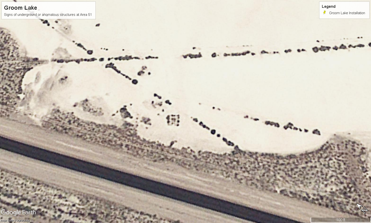
Lat: 37°15'3.73"N
Long: 115°49'19.59"W
Should be able to plug it right into Google Earth
Bottom NW corner of the dry lake bed
It is man made whatever it is. Looks consistent with a ramp leading to a door of some sort. The whole thing measures ~20ft. across
Yes
Lat: 37°15'3.73"N
Long: 115°49'19.59"W
Should be able to plug it right into Google Earth
Bottom NW corner of the dry lake bed
It is man made whatever it is. Looks consistent with a ramp leading to a door of some sort. The whole thing measures ~20ft. across
edit on
4/10/2019 by JBurns because: (no reason given)
Two B-52’s side by side is 370 feet.
Why on earth would they need anything that size... 😉
Why on earth would they need anything that size... 😉
a reply to: KKLOCO
I could not tell you that one, my only point is that *if* it were evidence of an underground transportation network it would be rather large. I mentioned the witness statement because it also described a very large tunnel. Of course that isn't proof of anything, just thought it was interesting to note
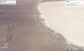
The sunken areas (not the dry lake entrance, but photo group #3) measure ~300ft across in total, whereas the semi-defined "road-like" area is just under 100ft across. So definitely too small for even a single B-52 if this is a tunnel, although a train/subway/even highway type network is very possible
I could not tell you that one, my only point is that *if* it were evidence of an underground transportation network it would be rather large. I mentioned the witness statement because it also described a very large tunnel. Of course that isn't proof of anything, just thought it was interesting to note
The sunken areas (not the dry lake entrance, but photo group #3) measure ~300ft across in total, whereas the semi-defined "road-like" area is just under 100ft across. So definitely too small for even a single B-52 if this is a tunnel, although a train/subway/even highway type network is very possible
a reply to: JBurns
For the last 2 years I've been living in Rotterdam. This is the first place I have ever heard "the hum". "The hum" is a very low frequency sound that is heard in some cities world-wide. Usually it is short in duration but seems to resonate in the head/body and permeate all other sound. I googled it in Holland and many people in this large city and other cities have reported hearing it. The authorities have tried to pinpoint the location using various devices but have never been successful.
The first time I heard it was strange. 1 am convinced that much underground drilling/mining has taken place to construct something because there's no way this sound can come from above ground. DUMB's, secret high-speed transit networks or something of a similar nature would be my guess but I have no evidence to back that up.
edit on 10/4/19 by LightSpeedDriver because: Typo
a reply to: LightSpeedDriver
Fascinating information LightSpeedDriver
It really makes you wonder what is happening when you hear these noises. For what its worth, folks in Los Alamos had the same type of experiences and it eventually turned out to be a Top Secret cold war era tunnel/physics lab/nuclear stewardship facility running directly under the Los Alamos McDonalds
Another theory would be ELF/LF radio waves, some of those effects (like you describe) have been documented in humans exposed to them especially for extended periods of time. I believe these are used as one way to communicate with nuclear subs, possibly to do weather engineering experiments (like HAARP), etc
From the Wikipedia article on HAARP, I found the following:
Although this would likely be something other than HAARP itself, I thought it was intriguing to note some similarities here!
If you were so inclined, you could either use open source aerial photos or even pay a couple hundred bucks to task a commercial satellite to acquire photography of your area. Look for anomalies and other signs of a belowground presence (entrances, exists, air shafts, utilities, and lots of heavy construction equipment moving in and out).
Here's a good example from our White House:
Utility shafts like this: www.trumanlibrary.org...
Require above ground sites like this: www.trumanlibrary.org...
Which makes the installation vulnerable to detection
Thanks for dropping by, you have me interested in your area now. Perhaps I will pull up some maps and imagery of the location you mentioned and see if anything jumps out as suspicious
Happy DUCC/DUMB hunting
Fascinating information LightSpeedDriver
It really makes you wonder what is happening when you hear these noises. For what its worth, folks in Los Alamos had the same type of experiences and it eventually turned out to be a Top Secret cold war era tunnel/physics lab/nuclear stewardship facility running directly under the Los Alamos McDonalds
Another theory would be ELF/LF radio waves, some of those effects (like you describe) have been documented in humans exposed to them especially for extended periods of time. I believe these are used as one way to communicate with nuclear subs, possibly to do weather engineering experiments (like HAARP), etc
From the Wikipedia article on HAARP, I found the following:
Some of the main scientific findings from HAARP include:
Generating very low frequency (VLF) radio waves by modulated heating of the auroral electrojet, useful because generating VLF waves ordinarily requires gigantic antennas
Generating artificial Airglow, which is typically subvisual but routinely detectable. Under certain geophysical conditions and transmitter configurations, it can be bright enough to observe with the unaided eye.[15][16]
Generating extremely low frequency (ELF) waves in the 0.1 Hz range. These are next to impossible to produce any other way, because the length of an antenna is dictated by the wavelength of the signal it emits or receives.
Generating whistler-mode VLF signals that enter the magnetosphere and propagate to the other hemisphere, interacting with Van Allen radiation belt particles along the way
VLF remote sensing of the heated ionosphere
Research at the HAARP has included:
Plasma line observations
Stimulated electron emission observations
Gyro frequency heating research
Spread F observations (blurring of ionospheric echoes of radio waves due to irregularities in electron density in the F layer)
High-velocity trace runs
Airglow observations[17]
Heating induced scintillation observations
VLF and ELF generation observations[18]
Radio observations of meteors
Polar mesospheric summer echoes (PMSE) have been studied, probing the mesosphere using the IRI as a powerful radar, and with a 28 MHz radar and two VHF radars at 49 MHz and 139 MHz. The presence of multiple radars spanning both HF and VHF bands allows scientists to make comparative measurements that may someday lead to an understanding of the processes that form these elusive phenomena.
Research into extraterrestrial HF radar echos: the Lunar Echo experiment (2008).[19][20]
Testing of Spread Spectrum Transmitters (2009)
Meteor shower impacts on the ionosphere
Response and recovery of the ionosphere from solar flares and geomagnetic storms
The effect of ionospheric disturbances on GPS satellite signal quality
Producing high density plasma clouds in Earth's upper atmosphere[21]
Underground imaging.[22]
Research conducted at the HAARP facility has allowed the US military to perfect communications with its fleet of submarines by sending radio signals over long distances.
Although this would likely be something other than HAARP itself, I thought it was intriguing to note some similarities here!
If you were so inclined, you could either use open source aerial photos or even pay a couple hundred bucks to task a commercial satellite to acquire photography of your area. Look for anomalies and other signs of a belowground presence (entrances, exists, air shafts, utilities, and lots of heavy construction equipment moving in and out).
Here's a good example from our White House:
Utility shafts like this: www.trumanlibrary.org...
Require above ground sites like this: www.trumanlibrary.org...
Which makes the installation vulnerable to detection
Thanks for dropping by, you have me interested in your area now. Perhaps I will pull up some maps and imagery of the location you mentioned and see if anything jumps out as suspicious
Happy DUCC/DUMB hunting
a reply to: JBurns
Interesting, and it would be more surprising if there were no underground facilities thee, than if some were located. Secretive base, for who knows what sort of testing, and tons of security even now? Safe bet there are underground areas. Standard for this sort of business. Some wouldn't even be "secret" in the usual sense, and could be for maintenance, etc. Some, of course, would be far different.
It's the ones in other areas that interest me. I know an area where they were removing lots of rock and whatnot from underground, with a conveyor sort of device, for at least a year, maybe two, and nothing was ever built there, but a small "pillbox" type building, with no signs, and a large air intake pipe coming out inside the surrounding fencing. This was all done right next to road construction that went on for years, and wasn't really needed, that did provide camouflage for whatever this was. No road to this building, no parking, nothing. Very strange.
Seeing as the images in the OP can be viewed on g**gle earth I have to assume that any image of Groom Lake that is able to be seen publicly is either
not what's really there or carefully placed there to distract.
I would wager that the fine people at alphabet are logging IPs of everyone who types in coordinates to Groom Lake and archiving them for counterintelligence.
I would wager that the fine people at alphabet are logging IPs of everyone who types in coordinates to Groom Lake and archiving them for counterintelligence.
a reply to: ColdWisdom
They went out of their way to plant shrubs/bushes of some sort around it. Looks like someone was trying to hide it. Before high resolution photography, the whole area would've appeared as a white blob and been undetectable.
The real question is, with most of GL exposed why go through the trouble of this under-lake area?
Also, the subsiding ground in a snaking pathway is quite a curiosity.
FYI, I wouldn't be too quick to knock open sources. Did you realize that 80%+ of intelligence material is derived from open sources?
If you'd like to refute the evidence at hand however, feel free to do so If the main base is used to test stealth, weapons, nuclear engines and other R&D toys... this must be pretty darn secret by my estimates whatever goes on down there... don't want anybody seeing that... not even GL staff?
a reply to: JBurns
I'm not knocking the validity and usefulness of open sources, just specifically the source mentioned. And though it wouldn't shock me to learn that 80% of intelligence gathered comes from open sources, I wonder, do you have source to corroborate that claim? Seems like something of that nature couldn't be known since collection statistics for intel agencies aren't published (for obvious reasons).
FYI, I wouldn't be too quick to knock open sources. Did you realize that 80%+ of intelligence material is derived from open sources?
I'm not knocking the validity and usefulness of open sources, just specifically the source mentioned. And though it wouldn't shock me to learn that 80% of intelligence gathered comes from open sources, I wonder, do you have source to corroborate that claim? Seems like something of that nature couldn't be known since collection statistics for intel agencies aren't published (for obvious reasons).
a reply to: ColdWisdom
www.cia.gov...
I stand corrected, it is "as much as 80%"
Although it does mention that OSINT in general is more useful against penetrating "closed borders" than "open societies" as well as "[OSINT] can shine in particular against the hardest of hard targets"
I would say GL is likely one of the hardest of hard targets
EDIT: As to your point about Google, I do agree here. However, they aren't the only imagery provider I use to double check their images of '51 to ensure cropping did not occur (or at least is less likely to have occurred). This structure appears in others as well. Part of the reason I think Google would avoid cropping is because those comparing their images to others would see the cropped area stand out like a sore thumb. For instance, if this area were to be blurred out in Google (or just removed) some artifact would remain (pixel distortion, lighting abnormality, etc) that would be akin to putting a large red blinking light on the area. In this case, seeing the shrubbery planted along the walls of this thing, it immediately tells me somebody went through the effort in an attempt to seemingly obscure it.. why? IMO it makes it less plausibly deniable when such things are eventually discovered
www.cia.gov...
Not only are open sources increasingly accessible, ubiquitous, and valuable, but they can shine in particular against the hardest of hard targets. OSINT is at times the "INT" of first resort, last resort, and every resort in between.
To some, this assertion may represent an overselling of OSINT. Arthur Hulnick, a former CIA officer who went on to teach at Boston University has written about OSINT's importance: "Neither glamorous nor adventurous, open sources are nonetheless the basic building block for secret intelligence." He has also noted how OSINT, whether conveyed via FBIS or CNN, provides early warning. He has even estimated that open sources may account for "as much as 80 percent" of the intelligence database in general. Nevertheless, Hulnick has suggested that OSINT would probably be far less useful against such tough cases as North Korea.
However, open sources may often be more useful in penetrating closed borders than open societies.
I stand corrected, it is "as much as 80%"
Although it does mention that OSINT in general is more useful against penetrating "closed borders" than "open societies" as well as "[OSINT] can shine in particular against the hardest of hard targets"
I would say GL is likely one of the hardest of hard targets
EDIT: As to your point about Google, I do agree here. However, they aren't the only imagery provider I use to double check their images of '51 to ensure cropping did not occur (or at least is less likely to have occurred). This structure appears in others as well. Part of the reason I think Google would avoid cropping is because those comparing their images to others would see the cropped area stand out like a sore thumb. For instance, if this area were to be blurred out in Google (or just removed) some artifact would remain (pixel distortion, lighting abnormality, etc) that would be akin to putting a large red blinking light on the area. In this case, seeing the shrubbery planted along the walls of this thing, it immediately tells me somebody went through the effort in an attempt to seemingly obscure it.. why? IMO it makes it less plausibly deniable when such things are eventually discovered
edit on 4/10/2019 by JBurns because: (no reason given)
a reply to: JBurns
It’s not really that important and I don’t want to dwell on it but as per your source:
Ok so moving on...
Any corporation, country, or military with a satellite in earth’s orbit can observe the surface level of Groom Lake. Then you have to consider ground penetrating radar, subsurface heat signatures, anomalous radiation, etc. I imagine there is probably one or more kinds of high technology being used to disrupt, distort, or dilute any measurements that can be made of GL from surface to air.
I suspect that what you see on gurgle maps is a composite of GL made up of real photos taken some several months to years prior to now, and any structures that seem to come and go are only added to the composite image once their purpose has been fulfilled, or like I said they’re just visual distractions.
I’m just speculating, though. Who can know such things and live to talk about them?
It’s not really that important and I don’t want to dwell on it but as per your source:
He has even estimated that open sources may account for "as much as 80 percent" of the intelligence database in general.
Ok so moving on...
Any corporation, country, or military with a satellite in earth’s orbit can observe the surface level of Groom Lake. Then you have to consider ground penetrating radar, subsurface heat signatures, anomalous radiation, etc. I imagine there is probably one or more kinds of high technology being used to disrupt, distort, or dilute any measurements that can be made of GL from surface to air.
I suspect that what you see on gurgle maps is a composite of GL made up of real photos taken some several months to years prior to now, and any structures that seem to come and go are only added to the composite image once their purpose has been fulfilled, or like I said they’re just visual distractions.
I’m just speculating, though. Who can know such things and live to talk about them?
Seems to me like an obvious case of paradolia -- it's goofy how our brains fill in these gaps for us when trying to make sense of the world.
a reply to: DavidDuchovny
Is it your contention that straight lines occur in nature?
earthobservatory.nasa.gov...
As shown by the example image of a below-ground house, this "U" pattern is common when grading down to an entrance for a below ground structure
The latest data collected by Russia's open skies flight - assuming it is made public or "finds" it way into the public domain - should be very useful as well.
Edit: Just saw your join date was today, welcome to ATS!
Is it your contention that straight lines occur in nature?
earthobservatory.nasa.gov...
Look for patterns, shapes, and textures
If you have ever spent an afternoon identifying animals and other shapes in the clouds, you’ll know that humans are very good at finding patterns. This skill is useful in interpreting satellite imagery because distinctive patterns can be matched to external maps to identify key features.
Bodies of water—rivers, lakes, and oceans—are often the simplest features to identify because they tend to have unique shapes and they show up on maps.
Other obvious patterns come from the way people use the land. Farms usually have geometric shapes—circles or rectangles—that stand out against the more random patterns seen in nature. When people cut down a forest, the clearing is often square or has a series of herring-bone lines that form along roads. A straight line anywhere in an image is almost certainly human-made, and may be a road, a canal, or some kind of boundary made visible by land use.
As shown by the example image of a below-ground house, this "U" pattern is common when grading down to an entrance for a below ground structure
The latest data collected by Russia's open skies flight - assuming it is made public or "finds" it way into the public domain - should be very useful as well.
Edit: Just saw your join date was today, welcome to ATS!
edit on 4/10/2019 by JBurns because: (no reason given)
a reply to: ColdWisdom
Indeed You were correct, although I am impressed I got the 80% figure correct
I believe that various penetrating radars, SAR, FLIR and others could be thwarted by the presence of salt and other minerals in a liquid (or moist) state. Determining what natural or topographical formations could deter such radars was actually part of my criteria for a good search location for underground facilities at GL
I figured that natural formations combined with depth could be used as an effective shield against these technologies, and would represent an attractive place to build such a thing
Assuming the image wasn't tampered with (I did use multiple imagery sources to vet it before posting it here) what do you think about it? The use of a dry salt lake (usually dry, moisture and wet season withstanding) in conjunction with natural camo techniques is interesting. The use of a formation consistent with a down-grade to a door or entryway of some sort is also intriguing
Seems to me the government stands to gain a lot by this train of thought. In actuality, they are simply human beings like the rest of us who are error prone and quite susceptible to the same shortcomings and downfalls the rest of us have. They are far from omniscient
In any case, the feedback is always appreciated And I think any in-depth analysis of this facility helps contribute to the overall picture of this location. A healthy dose of skepticism is never a bad thing
Indeed You were correct, although I am impressed I got the 80% figure correct
I believe that various penetrating radars, SAR, FLIR and others could be thwarted by the presence of salt and other minerals in a liquid (or moist) state. Determining what natural or topographical formations could deter such radars was actually part of my criteria for a good search location for underground facilities at GL
I figured that natural formations combined with depth could be used as an effective shield against these technologies, and would represent an attractive place to build such a thing
Assuming the image wasn't tampered with (I did use multiple imagery sources to vet it before posting it here) what do you think about it? The use of a dry salt lake (usually dry, moisture and wet season withstanding) in conjunction with natural camo techniques is interesting. The use of a formation consistent with a down-grade to a door or entryway of some sort is also intriguing
Who can know such things and live to talk about them?
Seems to me the government stands to gain a lot by this train of thought. In actuality, they are simply human beings like the rest of us who are error prone and quite susceptible to the same shortcomings and downfalls the rest of us have. They are far from omniscient
In any case, the feedback is always appreciated And I think any in-depth analysis of this facility helps contribute to the overall picture of this location. A healthy dose of skepticism is never a bad thing
a reply to: JBurns
It doesn't have to be tampered with, it just doesn't have to be the right date. If it were me, I'd think photo manipulation artifacts would be where everyone would look the most, so I'd give them real unedited shots, just of GL from a different date or of perhaps even a completely different terrain that looks close enough to identical that no one would question where the photos were taken.
One point you made that I forgot to address is comparing present shots of GL from multiple sources. How many different sources online and off allow you to view satellite/aerial photos of GL?
One niche angle in this topic that would be really interesting to look into is just how many different present day satellite/aerial photographs of GL exist?
How were they taken?
When were they taken?
When were they published?
Who owns or funds the corporate entities that publish these photos?
Who owns the patents to and/or funds the machines both in air and space that captured these images?
How frequent do they update?
And so on and so forth, but you get the idea: a pinpoint focus on who controls the information available to the public pertaining to GL.
Assuming the image wasn't tampered with (I did use multiple imagery sources to vet it before posting it here) what do you think about it?
It doesn't have to be tampered with, it just doesn't have to be the right date. If it were me, I'd think photo manipulation artifacts would be where everyone would look the most, so I'd give them real unedited shots, just of GL from a different date or of perhaps even a completely different terrain that looks close enough to identical that no one would question where the photos were taken.
One point you made that I forgot to address is comparing present shots of GL from multiple sources. How many different sources online and off allow you to view satellite/aerial photos of GL?
One niche angle in this topic that would be really interesting to look into is just how many different present day satellite/aerial photographs of GL exist?
How were they taken?
When were they taken?
When were they published?
Who owns or funds the corporate entities that publish these photos?
Who owns the patents to and/or funds the machines both in air and space that captured these images?
How frequent do they update?
And so on and so forth, but you get the idea: a pinpoint focus on who controls the information available to the public pertaining to GL.
What are your thoughts about Phil Schneider as it pertains to DUMBS? His story is absolutely incredible if true.
Although his death was ruled a suicide, anyone with a peanut for a brain could see it was foul play.
S&F
Although his death was ruled a suicide, anyone with a peanut for a brain could see it was foul play.
S&F
originally posted by: EternalShadow
What are your thoughts about Phil Schneider as it pertains to DUMBS? His story is absolutely incredible if true.
Although his death was ruled a suicide, anyone with a peanut for a brain could see it was foul play.
S&F
Yeah, all you have to do is google his death photo. That was no suicide. They didn’t even try to make it believable.
new topics
-
Bobiverse
Fantasy & Science Fiction: 1 hours ago -
Florida man's trip overseas ends in shock over $143,000 T-Mobile phone bill
Social Issues and Civil Unrest: 1 hours ago -
Former Labour minister Frank Field dies aged 81
People: 3 hours ago -
SETI chief says US has no evidence for alien technology. 'And we never have'
Aliens and UFOs: 5 hours ago -
This is our Story
General Entertainment: 8 hours ago -
President BIDEN Vows to Make Americans Pay More Federal Taxes in 2025 - Political Suicide.
2024 Elections: 10 hours ago -
Ode to Artemis
General Chit Chat: 11 hours ago
top topics
-
President BIDEN Vows to Make Americans Pay More Federal Taxes in 2025 - Political Suicide.
2024 Elections: 10 hours ago, 14 flags -
Should Biden Replace Harris With AOC On the 2024 Democrat Ticket?
2024 Elections: 16 hours ago, 6 flags -
One Flame Throwing Robot Dog for Christmas Please!
Weaponry: 14 hours ago, 6 flags -
Don't take advantage of people just because it seems easy it will backfire
Rant: 15 hours ago, 4 flags -
Ditching physical money
History: 14 hours ago, 4 flags -
SETI chief says US has no evidence for alien technology. 'And we never have'
Aliens and UFOs: 5 hours ago, 4 flags -
Ode to Artemis
General Chit Chat: 11 hours ago, 3 flags -
Former Labour minister Frank Field dies aged 81
People: 3 hours ago, 3 flags -
VirginOfGrand says hello
Introductions: 15 hours ago, 2 flags -
This is our Story
General Entertainment: 8 hours ago, 2 flags
active topics
-
President BIDEN Vows to Make Americans Pay More Federal Taxes in 2025 - Political Suicide.
2024 Elections • 44 • : CriticalStinker -
The Reality of the Laser
Military Projects • 35 • : DronesandUFOs -
Breaking Baltimore, ship brings down bridge, mass casualties
Other Current Events • 475 • : ArMaP -
Bobiverse
Fantasy & Science Fiction • 1 • : TzarChasm -
So this is what Hamas considers 'freedom fighting' ...
War On Terrorism • 255 • : network dude -
SETI chief says US has no evidence for alien technology. 'And we never have'
Aliens and UFOs • 22 • : Ophiuchus1 -
Police clash with St George’s Day protesters at central London rally
Social Issues and Civil Unrest • 43 • : SprocketUK -
Mood Music Part VI
Music • 3097 • : TheWoker -
Post A Funny (T&C Friendly) Pic Part IV: The LOL awakens!
General Chit Chat • 7132 • : watchitburn -
"We're All Hamas" Heard at Columbia University Protests
Social Issues and Civil Unrest • 271 • : TzarChasm