It looks like you're using an Ad Blocker.
Please white-list or disable AboveTopSecret.com in your ad-blocking tool.
Thank you.
Some features of ATS will be disabled while you continue to use an ad-blocker.

Two Quakes just hit Vancouver Island 6.6 and 6.8
page: 1share:
I didn’t feel it, kind of concerned to have two of this magnitude so close in proximity and time
6.6
Date-Time
22 Oct 2018 05:39:40 UTC
21 Oct 2018 22:39:40 near epicenter
21 Oct 2018 21:39:40 standard time in your timezone
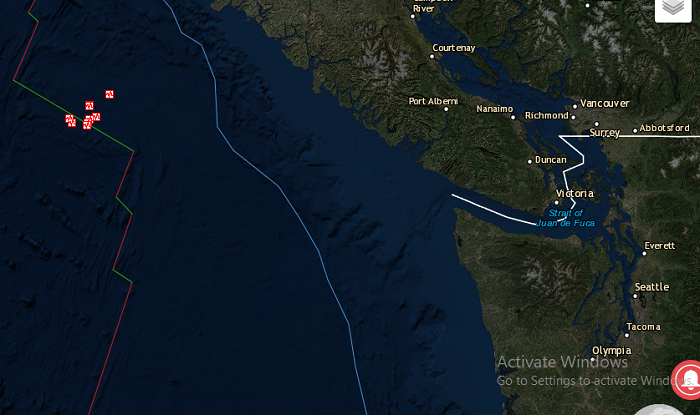
Location 49.250N 129.478W
Depth 10 km
Distances
260.4 km (161.5 mi) W of Tofino, Canada
317.5 km (196.8 mi) WSW of Campbell River, Canada
328.6 km (203.7 mi) W of Courtenay, Canada
340.4 km (211.0 mi) W of Port Alberni, Canada
457.4 km (283.6 mi) W of Victoria, Canada
Location Uncertainty Horizontal: 6.5 km; Vertical 3.4 km
Parameters Nph = 135; Dmin = 182.5 km; Rmss = 1.36 seconds; Gp = 70°
Version =
Event ID us 1000hfgn
Then this one
6.8
Date-Time
22 Oct 2018 06:16:28 UTC
21 Oct 2018 23:16:28 near epicenter
21 Oct 2018 22:16:28 standard time in your timezone
Location 49.347N 129.214W
Depth 10 km
Distances
241.6 km (149.8 mi) W of Tofino, Canada
295.9 km (183.5 mi) WSW of Campbell River, Canada
307.9 km (190.9 mi) W of Courtenay, Canada
321.0 km (199.0 mi) W of Port Alberni, Canada
440.3 km (273.0 mi) W of Victoria, Canada
Location Uncertainty Horizontal: 6.5 km; Vertical 1.8 km
Parameters Nph = 175; Dmin = 163.5 km; Rmss = 1.40 seconds; Gp = 62°
Version =
Event ID us 1000hfgv
earthquake.usgs.gov...
6.6
Date-Time
22 Oct 2018 05:39:40 UTC
21 Oct 2018 22:39:40 near epicenter
21 Oct 2018 21:39:40 standard time in your timezone
Location 49.250N 129.478W
Depth 10 km
Distances
260.4 km (161.5 mi) W of Tofino, Canada
317.5 km (196.8 mi) WSW of Campbell River, Canada
328.6 km (203.7 mi) W of Courtenay, Canada
340.4 km (211.0 mi) W of Port Alberni, Canada
457.4 km (283.6 mi) W of Victoria, Canada
Location Uncertainty Horizontal: 6.5 km; Vertical 3.4 km
Parameters Nph = 135; Dmin = 182.5 km; Rmss = 1.36 seconds; Gp = 70°
Version =
Event ID us 1000hfgn
Then this one
6.8
Date-Time
22 Oct 2018 06:16:28 UTC
21 Oct 2018 23:16:28 near epicenter
21 Oct 2018 22:16:28 standard time in your timezone
Location 49.347N 129.214W
Depth 10 km
Distances
241.6 km (149.8 mi) W of Tofino, Canada
295.9 km (183.5 mi) WSW of Campbell River, Canada
307.9 km (190.9 mi) W of Courtenay, Canada
321.0 km (199.0 mi) W of Port Alberni, Canada
440.3 km (273.0 mi) W of Victoria, Canada
Location Uncertainty Horizontal: 6.5 km; Vertical 1.8 km
Parameters Nph = 175; Dmin = 163.5 km; Rmss = 1.40 seconds; Gp = 62°
Version =
Event ID us 1000hfgv
earthquake.usgs.gov...
edit on 22-10-2018 by violet because: (no reason given)
edit on 22-10-2018 by violet because: (no reason
given)
edit on 22-10-2018 by violet because: (no reason given)
edit on 22-10-2018 by violet because: (no reason
given)
Awe you beat me to it !! DOOM ON !!!!! Lets follow it south and east now following the fault lines remember deep produces bigger shallower it would
be good to look at the last few days/weeks to see where this stemmed from.look north and west of it.... Also hisorically looking at the sequence of
previous eq's in that area will give you a pretty good idea of whats to come....
Oh and just in time as in right before elections 2 weeks n counting...
Oh and just in time as in right before elections 2 weeks n counting...
edit on 22-10-2018 by TheJesuit because: (no reason given)
No tsunami warning by the way
Both looked to be right on the Juan de fuca plate where it joins with the pacific plate , the first one being further up the Juan de Fuca
Both looked to be right on the Juan de fuca plate where it joins with the pacific plate , the first one being further up the Juan de Fuca
a reply to: TheJesuit
Oh .god I hope it’s not doom on , since I live near vancouver!
Never felt either though and I’ve been sitting pretty still
I keep thinking though we are due for the BIG ONE!
It’s like they’re travelling down the one plate , not sure what that means.
Oh .god I hope it’s not doom on , since I live near vancouver!
Never felt either though and I’ve been sitting pretty still
I keep thinking though we are due for the BIG ONE!
It’s like they’re travelling down the one plate , not sure what that means.
a reply to: dreamingawake
Yeah I saw them popping up on my apps . I was stunned because all the ones over 6 ( which I only get alerts for) are usually in the Tonga region etc. Never near me. Except that one we had in Haida a few years back.
I was going to bed early for once until the excitement started
Yeah I saw them popping up on my apps . I was stunned because all the ones over 6 ( which I only get alerts for) are usually in the Tonga region etc. Never near me. Except that one we had in Haida a few years back.
I was going to bed early for once until the excitement started
a reply to: TheJesuit
With recent history, and I believe this is way different from the past, from the PNSN shows it's been silent. I worded this wrong: “It’s a remarkable process, it’s what we call a ‘slow slip.’ It’s the surface of the North American plate moving backwards towards the ocean,” Cassidy explained.
Vancouver Island away from the coast
edit on 22-10-2018 by
dreamingawake because: fixed
a reply to: violet
Figures they'd happen around bedtime!
I don't see much yet for people reporting on feeling them, let alone reporting on it, anything for you guys?
I don't think any local Washington State news is sharing it either, seen Canada ones though and national US news.
Figures they'd happen around bedtime!
I don't see much yet for people reporting on feeling them, let alone reporting on it, anything for you guys?
I don't think any local Washington State news is sharing it either, seen Canada ones though and national US news.
I wonder if there is a correlation between this and the Mars volcanic eruption?
Are we allowed to speculate that wild?
Are we allowed to speculate that wild?
a reply to: dreamingawake
All the Canadian news outlets are reporting it and I’ve not read any comments so far on them being felt. My family live on the island but are all in bed unaware.
All the Canadian news outlets are reporting it and I’ve not read any comments so far on them being felt. My family live on the island but are all in bed unaware.
a reply to: dreamingawake
Isn’t the Juan de Fuca always on the move ever so slowly? Seems like it’s being squeezed by the Pacific and north American plate. I can’t recall which direction it’s always moving . I’d not live on the island! It might slide right under the mainland one day during the big one.
Isn’t the Juan de Fuca always on the move ever so slowly? Seems like it’s being squeezed by the Pacific and north American plate. I can’t recall which direction it’s always moving . I’d not live on the island! It might slide right under the mainland one day during the big one.
edit on 22-10-2018 by violet because: (no reason given)
a reply to: violet
Yes, the whole region is warping due to the movement flow and restrictions.
More from the link earlier shared to the EQ thread:
www.abovetopsecret.com...
Yes, the whole region is warping due to the movement flow and restrictions.
British Columbia however is part of rigid North America and moves with it. This results in the Puget Lowland being compressed and warped like an accordion with alternating uplifted and down warped terrain shortening the distance between Centralia, Washington, and the Canadia border. Dr. Ray Wells of the USGS developed a model to demonstrate this process and produced the cartoon animation located above the GPS Vector map.
More from the link earlier shared to the EQ thread:
Our work does suggest that a large event is more likely to start in either the northern or southern sections of the fault, where the plates are more fully locked, and gives a possible reason for why that may be the case.
www.abovetopsecret.com...
a reply to: dreamingawake
This is from an older article after there were smaller ones
www.foxnews.com...
This is from an older article after there were smaller ones
The cause for concern is what happens when the Juan de Fuca plate eventually submerges under the much larger Pacific plate. For approximately 330 years, the plate has continuously been pushed down, an activity that will eventually lead it to be pushed under the North America plate, causing the region to sink six feet on the minimum and may result in one of the largest earthquakes in human history.
If the entire 650-mile long Cascadia Subduction Zone (which includes the Juan de Fuca plate) were to experience a full rupture, it could not only trigger a 9.0 earthquake, but a tsunami as well.
The Juan De Fuca plate stretches from Northern California to British Columbia and the Cascadia Subduction Zone stretches from N. Vancouver Island to Cape Mendicino, California.
www.foxnews.com...
Sure hope Tofino is ok - I went there on my honeymoon last year and pray to God it stays around long enough to return!
South China Morning
Post
Hang on... Noticed this earlier. Within 24 hours of this news, in the exact same area?
What’s going on here that we’re not seeing? Chinese underwater monitoring posts?
Hang on... Noticed this earlier. Within 24 hours of this news, in the exact same area?
What’s going on here that we’re not seeing? Chinese underwater monitoring posts?
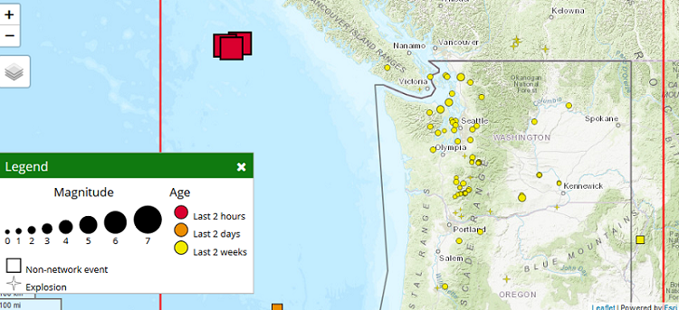
There were three quakes, 6.5, then 6.8, then 6.5, all within about 45 minutes, followed by 3 smaller quakes in the 4 range, see my source in the
earthquake thread.
edit on 22-10-2018 by AlexanderM because: (no reason given)
I'm surprised I've never heard anyone talk about the impacts of a large earthquake under the crust.
We've all seen lava flows, that stuff moves around pretty well, but is super dense. A huge earthquake that sends a tsunami hurling into Cali is also sending a massive sub-surface shockwave towards the super volcano hanging out just past there.
Talk about a bang.
We've all seen lava flows, that stuff moves around pretty well, but is super dense. A huge earthquake that sends a tsunami hurling into Cali is also sending a massive sub-surface shockwave towards the super volcano hanging out just past there.
Talk about a bang.
new topics
-
Las Vegas UFO Spotting Teen Traumatized by Demon Creature in Backyard
Aliens and UFOs: 1 hours ago -
2024 Pigeon Forge Rod Run - On the Strip (Video made for you)
Automotive Discussion: 2 hours ago -
Gaza Terrorists Attack US Humanitarian Pier During Construction
Middle East Issues: 2 hours ago -
The functionality of boldening and italics is clunky and no post char limit warning?
ATS Freshman's Forum: 3 hours ago -
Meadows, Giuliani Among 11 Indicted in Arizona in Latest 2020 Election Subversion Case
Mainstream News: 4 hours ago -
Massachusetts Drag Queen Leads Young Kids in Free Palestine Chant
Social Issues and Civil Unrest: 4 hours ago -
Weinstein's conviction overturned
Mainstream News: 5 hours ago -
Supreme Court Oral Arguments 4.25.2024 - Are PRESIDENTS IMMUNE From Later Being Prosecuted.
Above Politics: 7 hours ago -
Krystalnacht on today's most elite Universities?
Social Issues and Civil Unrest: 7 hours ago -
Chris Christie Wishes Death Upon Trump and Ramaswamy
Politicians & People: 8 hours ago
top topics
-
Krystalnacht on today's most elite Universities?
Social Issues and Civil Unrest: 7 hours ago, 9 flags -
Weinstein's conviction overturned
Mainstream News: 5 hours ago, 6 flags -
University of Texas Instantly Shuts Down Anti Israel Protests
Education and Media: 10 hours ago, 6 flags -
Supreme Court Oral Arguments 4.25.2024 - Are PRESIDENTS IMMUNE From Later Being Prosecuted.
Above Politics: 7 hours ago, 5 flags -
Massachusetts Drag Queen Leads Young Kids in Free Palestine Chant
Social Issues and Civil Unrest: 4 hours ago, 4 flags -
Meadows, Giuliani Among 11 Indicted in Arizona in Latest 2020 Election Subversion Case
Mainstream News: 4 hours ago, 4 flags -
Chris Christie Wishes Death Upon Trump and Ramaswamy
Politicians & People: 8 hours ago, 2 flags -
Any one suspicious of fever promotions events, major investor Goldman Sachs card only.
The Gray Area: 12 hours ago, 2 flags -
Gaza Terrorists Attack US Humanitarian Pier During Construction
Middle East Issues: 2 hours ago, 2 flags -
2024 Pigeon Forge Rod Run - On the Strip (Video made for you)
Automotive Discussion: 2 hours ago, 1 flags
active topics
-
Supreme Court Oral Arguments 4.25.2024 - Are PRESIDENTS IMMUNE From Later Being Prosecuted.
Above Politics • 67 • : Irishhaf -
Cats Used as Live Bait to Train Ferocious Pitbulls in Illegal NYC Dogfighting
Social Issues and Civil Unrest • 22 • : NoviceStoic4 -
Sunak spinning the sickness figures
Other Current Events • 22 • : angelchemuel -
Massachusetts Drag Queen Leads Young Kids in Free Palestine Chant
Social Issues and Civil Unrest • 10 • : Cre8chaos79 -
Nearly 70% Of Americans Want Talks To End War In Ukraine
Political Issues • 93 • : Xtrozero -
University of Texas Instantly Shuts Down Anti Israel Protests
Education and Media • 194 • : Irishhaf -
Fossils in Greece Suggest Human Ancestors Evolved in Europe, Not Africa
Origins and Creationism • 88 • : Xtrozero -
Gaza Terrorists Attack US Humanitarian Pier During Construction
Middle East Issues • 20 • : Justsomeboreddude3 -
Thousands Of Young Ukrainian Men Trying To Flee The Country To Avoid Conscription And The War
Other Current Events • 141 • : Consvoli -
Terrifying Encounters With The Black Eyed Kids
Paranormal Studies • 77 • : burritocat